Georgina River

Last updated

Georgina
Georgina River.jpg
Lake eyre basin map.png
Map of the Lake Eyre Basin showing Georgina River
EtymologyGeorgina, the daughter of Arthur Kennedy [1]
Location
Country Australia
State/territory Queensland, Northern Territory
Region Central West Queensland, Central Australia
City Boulia
Physical characteristics
Source Barkly Tableland
  locationnorth of Camooweal
Mouth confluence with the Eyre Creek
  elevation
97 m (318 ft)
Length1,130 km (700 mi) [2]
Basin size232,000 km2 (90,000 sq mi) [3]
Discharge 
  average22 m3/s (780 cu ft/s) [3]
  minimum0 m3/s (0 cu ft/s)
  maximum200 m3/s (7,100 cu ft/s)
Basin features
River system Lake Eyre basin
Tributaries 
  leftBuckley River, Templeton River, Burke River, Hamilton River
  right Herbert River (NT), Ranken River, Sandover River
[4] [5]

The Georgina River is the north-westernmost of the three major rivers of the Channel Country in Central West Queensland, that also flows through a portion of the Northern Territory, in central Australia. Part of the Lake Eyre basin, the Georgina flows in extremely wet years into Lake Eyre.

Contents

The river is named in honour of Georgina Mildred Kennedy, the daughter of Queensland governor Arthur Kennedy. [1] The river was originally called the Herbert River before being given its current name in 1890 to avoid confusion with the other river in Queensland that bears that name. [6]

Geography

With its headwaters rising in the Barkly Tableland, north of Camooweal in Queensland, and in the extreme east of the Northern Territory beyond Tennant Creek and to the south draining the northern slopes of the Macdonnell Ranges [ citation needed ], the Georgina is formed from several smaller streams over a wide area of north-western Queensland and the eastern Northern Territory. From source to mouth, the Georgina is joined by more than 35 tributaries including the Buckley, Templeton, Burke, Hamilton, Herbert, Ranken, and Sandover rivers; and flows through 26 billabongs. [4] [5] As the Georgina flows south into the Channel Country, it reaches a confluence with Eyre Creek that, in times of peak flow, empties into the Warburton River and ultimately into Lake Eyre. [7]

The basin of the Georgina totals around 232,000 square kilometres (90,000 sq mi), or about the same size as the Australian state of Victoria. Because it is so arid, however, its mean annual flow is only about 0.7 km3 (570,000 acre⋅ft). [3] There is such extreme variation that – although streamgauging records are too poor to prove it conclusively – meteorological records leave no doubt that there have been many years of zero runoff' in the entire basin (1905, 1928 and 1961 would without doubt fit into this category), whilst in very wet years such as 1974, 1977 and 2000, runoff can be as high as 6.28 km3 (5,090,000 acre⋅ft) or more. [8]

Although a small part of the Macdonnell Ranges drains into the Georgina, most of the catchment is a flat as the Diamantina, though low ranges are very prominent in the north-west of the basin. This western part of the basin has soils that are too infertile to provide nutritious fodder for cattle or sheep and a large proportion is an Aboriginal reserve. The eastern part of the Georgina catchment near Boulia is very similar to the Diamantina and Cooper basins, being grassy plains with heavy cracking clay soils that are quite fertile and provide very good feed in wet years for livestock. The Lake Machattie Area is an important breeding site for waterbirds.

Climate

Looking north up the dry river bed from the Georgina River Bridge at Camooweal, July 2019 Dry river bed of the Georgina River from the Georgina River Bridge at Camooweal looking north, July 2019.jpg
Looking north up the dry river bed from the Georgina River Bridge at Camooweal, July 2019

Climatically, the Georgina catchment tends to be somewhat drier than the Diamantina or Cooper, with average annual rainfall ranging from around 400 millimetres (16 in) north of Camooweal to around 225 millimetres (8.9 in) at Bedourie. [9]

Extremely dry years can give the entire basin less than 100 millimetres (3.9 in) whilst in 1974, 1977 and 2000 many areas had over 800 millimetres (31 in) and some as much as 1,000 millimetres (39 in). Almost all of this rain falls in the summer, and it is quite normal for the period from May to September to not record any measurable falls at all. In extremely wet summer months such as January 1974 or March 1950, most of the catchment can receive as much as 350 millimetres (14 in) in a month or 150 millimetres (5.9 in) in a day or two. Temperatures are generally hot, with most areas having maxima of over 30 °C (86 °F) on over 225 days per year. Frosts are rare but have been reported on occasions in all areas of the basin – however even in June and July maxima are around 25 °C (77 °F).

Flooding

Flooding near Bedourie, 2016 Georgina River flooding near Bedourie, 2016.jpg
Flooding near Bedourie, 2016

During severe floods the river can be as wide as 15 to 20 kilometres (9.3 to 12.4 mi) in the upper reaches and in the lower reaches from 25 to 30 kilometres (16 to 19 mi) wide. [10] Inundation can last for months at a time, which can disrupt road and rail transport in the area. The highest recorded flood occurred in January 1974. [10]

Flooding occurred at Glenormiston Station in 1885 when somewhere between 12 inches (305 mm) and 17 inches (432 mm) of rain fell over the course of a month. The Georgina River and the Diamatina Rivers both were flooded and the Sandringham station was submerged. [11]

The upper watershed in the Northern Territory were subjected to severe flooding in 1901 when Lake Nash Station experienced over 10 inches (254 mm) of rain in a single day, with the Georgina River running at almost record high levels. [12] The surrounding areas received over 4 inches (102 mm) of rain in 1953 resulting in the River rising over 23 feet (7 m), the highest level in over 36 years. [13]

The lower reaches flooded in 1950 and again in 1953 following heavy rain events further north. The 1953 flood was 6 inches (152 mm) higher at Glengyle Station compared to the 1950 event. The Diamantina River was also in flood and the waters were expected to make it to Lake Eyre. [14]

Moderate flooding was experienced along the river, including Glenormiston Station, in 2010 following heavy rains locally and further north in the Georgina catchment. [15]

Although it is the driest of the three main rivers of the Lake Eyre Basin, there is evidence that the Georgina has, in the past, actually reached the lake more frequently than either the Diamantina or Cooper. Some wave built shingle terraces suggest that during the Medieval Warm Period Lake Eyre held permanent water. Large increases since the late 1960s in rainfall over the Northern Territory and pastoral areas of South and Western Australia that have not been duplicated over Queensland do suggest an enhanced greenhouse effect in the Medieval Warm Period may have caused the Georgina to regularly fill Lake Eyre. However, far too little evidence exists for any certainty of this.

Georgina River Bridge at Camooweal

Driving across the Georgina River Bridge from Camooweal looking south at the dry river bed, 2019 Driving across the Georgina River Bridge from Camooweal looking south at the dry river bed, 2019 03.jpg
Driving across the Georgina River Bridge from Camooweal looking south at the dry river bed, 2019

Given the economic importance of transport on the Barkly Highway (the only sealed road between Queensland and the Northern Territory), a longstanding problem was the flooding of the Georgina River immediately west of Camooweal in Queensland. As the water levels in the Georgina River vary enormously from being completely dry to flooding, the Barkly Highway bridge over the Georgina River was often unusable for many days due to flooding, with road trains and other heavy vehicles having to wait weeks before it was safe to cross. To alleviate these problems, the Georgina River Bridge was officially opened on 20 December 2002 by Senator Ron Boswell and Steve Breadhauer, Minister for Transport in the Queensland Government. It replaced the previous bridge which was approximately 50 metres (160 ft) south, and is both higher and longer so traffic on the highway can continue to cross during floods. The bridge is 417 metres (1,368 ft) long and is accompanied by a 5.6-kilometre (3.5 mi) highway deviation west from Camooweal. The bridge uses an unusual arch design to avoid placing pylons into the river bed which is culturally significant to the local Dugalunji people, who call the new bridge Ilaga Thuwani meaning The Camping Ground of the Rainbow Serpent . [16] [17] [18] [19]

See also

Related Research Articles

<span class="mw-page-title-main">Lake Eyre</span> Endorheic lake in South Australia

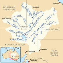
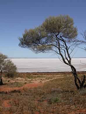
Lake Eyre, officially known as Kati Thanda–Lake Eyre, is an endorheic lake in east-central Far North South Australia, some 700 km (435 mi) north of Adelaide. The shallow lake is the depocentre of the vast endorheic Lake Eyre basin, and contains the lowest natural point in Australia at approximately 15 m (49 ft) below sea level (AHD), and on the rare occasions that it fills completely, is the largest lake in Australia covering an area up to 9,500 km2 (3,668 sq mi). When the lake is full, it has the same salinity level as seawater, but becomes hypersaline as the lake dries up and the water evaporates.

<span class="mw-page-title-main">Tropic of Capricorn</span> Line of southernmost latitude at which the sun can be directly overhead

The Tropic of Capricorn is the circle of latitude that contains the subsolar point at the December solstice. It is thus the southernmost latitude where the Sun can be seen directly overhead. It also reaches 90 degrees below the horizon at solar midnight on the June Solstice. Its northern equivalent is the Tropic of Cancer.

<span class="mw-page-title-main">Burdekin River</span> River in Queensland, Australia

The Burdekin River is a river located in North and Far North Queensland, Australia. The river rises on the northern slopes of Boulder Mountain at Valley of Lagoons, part of the western slope of the Seaview Range, and flows into the Coral Sea at Upstart Bay over 200 kilometres (124 mi) to the southeast of the source, with a catchment area of approximately 130,000 square kilometres (50,000 sq mi). The Burdekin River is Australia's largest river by (peak) discharge volume.

<span class="mw-page-title-main">Diamantina River</span> River in South Australia, Australia

The Diamantina River is a major river located in Central West Queensland and the far north of South Australia.

<span class="mw-page-title-main">Lake Eyre basin</span> Place in *Queensland *South Australia *Northern Territory *New South Wales, Australia

The Lake Eyre basin is a drainage basin that covers just under one-sixth of all Australia. It is the largest endorheic basin in Australia and amongst the largest in the world, covering about 1,200,000 square kilometres (463,323 sq mi), including much of inland Queensland, large portions of South Australia and the Northern Territory, and a part of western New South Wales. The basin is also one of the largest, least-developed arid zone basins with a high degree of variability anywhere. It supports only about 60,000 people and has no major irrigation, diversions or flood-plain developments. Low density grazing that sustains a large amount of wildlife is the major land use, occupying 82% of the total land within the basin. The Lake Eyre basin of precipitation to a great extent geographically overlaps the Great Artesian Basin underneath.

<span class="mw-page-title-main">Cooper Creek</span> River in Queensland, South Australia

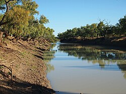
The Cooper Creek is a river in the Australian states of Queensland and South Australia. It was the site of the death of the explorers Burke and Wills in 1861. It is sometimes known as the Barcoo River from one of its tributaries and is one of three major Queensland river systems that flow into the Lake Eyre basin. The flow of the creek depends on monsoonal rains falling months earlier and many hundreds of kilometres away in eastern Queensland. It is 1,300 kilometres (810 mi) in length.

<span class="mw-page-title-main">Camooweal</span> Town in Queensland, Australia

Camooweal is an outback town and locality in the City of Mount Isa, Queensland, Australia. The locality is on the Queensland border with the Northern Territory. In the 2021 census, the locality of Camooweal had a population of 236 people.

<span class="mw-page-title-main">Channel Country</span> Bioegion in Australia

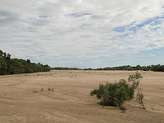
The Channel Country is a region of outback Australia mostly in the state of Queensland but also in parts of South Australia, Northern Territory and New South Wales. The name comes from the numerous intertwined rivulets that cross the region, which cover 150,000 km². The Channel Country is over the Cooper and Eromanga geological basins and the Lake Eyre Basin drainage basin. Further to the east is the less arid Maranoa district.

<span class="mw-page-title-main">Barkly Highway</span> Highway in the Northern Territory and Queensland

The Barkly Highway is a national highway of both Queensland and the Northern Territory in Australia. It is the only sealed road between Queensland and the Northern Territory.

<span class="mw-page-title-main">Northern Australia</span> Northern regions of Western Australia, Northern Territory and Queensland in Australia

The unofficial geographic term Northern Australia includes those parts of Queensland and Western Australia north of latitude 26° and all of the Northern Territory. Those local government areas of Western Australia and Queensland that lie partially in the north are included.

<span class="mw-page-title-main">Clarence River (New South Wales)</span> River in New South Wales, Australia

The Clarence River is a river situated in the Northern Rivers district of New South Wales, Australia.

The Sandover River is an ephemeral river in the Northern Territory of Australia located in northeast Central Australia. It is the only major tributary of the Georgina River that does not rise in western Queensland. Instead it flows from the eastern Macdonnell Ranges, northward to enter the Georgina near Urandangi. The highest point in the catchment is Bald Hill at 996 metres (3,268 ft), but it enters the Georgina at altitudes below 200 metres (660 ft).

<span class="mw-page-title-main">Bulloo River</span> River in Queensland, Australia

The Bulloo RiverBUUL-oo is an isolated drainage system in western Queensland, central Australia. Its floodplain, which extends into northern New South Wales, is an important area for waterbirds when inundated. It comprises most of the Bulloo-Bancannia drainage basin.

The 1950 rainfall records for the Australian states of New South Wales and Queensland reported probably the most remarkable record high rainfall totals ever recorded anywhere in the continent. Averaged over both of these states, 1950 is clearly the wettest year since adequate records became available circa 1885. Queensland recorded a statewide average rainfall of around 1,125 millimetres (44.3 in) as against a mean since 1885 of around 640 millimetres (25.2 in), whilst New South Wales recorded around 930 millimetres (36.6 in) as against an instrumental mean around 520 millimetres (20.5 in). Australia's wettest town, Tully also recorded its highest annual rainfall total in 1950 with 7,925 millimetres (312.0 in).

<span class="mw-page-title-main">Burke River (Queensland)</span> River in Queensland, Australia

The Burke River is an ephemeral river in Central West Queensland, Australia. The river was named in memory of Robert O'Hara Burke of the Burke and Wills expedition.

Heavy rain in March 2010 saw much of south western and central Queensland undergo major flooding. The floods saw inundation of the towns of Charleville, Roma, St George and Theodore among others. Major rivers affected include the Balonne River, Bulloo River, Paroo River and the Dawson River.

<span class="mw-page-title-main">Macumba River</span> River in South Australia

Macumba River, once known as Treuer River, is an ephemeral freshwater stream in the far north of South Australia, that is part of the Lake Eyre Basin.

<span class="mw-page-title-main">Lake Nash Station</span> Cattle station in Northern Territory

Lake Nash Station, most commonly known as Lake Nash, is a cattle station on the Barkly Tableland in the Northern Territory, Australia.

<span class="mw-page-title-main">Glengyle Station</span> Pastoral lease in central west Queensland

Glengyle Station most commonly known as Glengyle is a pastoral lease that operates as a cattle station in central west Queensland.

<span class="mw-page-title-main">Tree of Knowledge, Camooweal</span> Historic site in Queensland, Australia

Tree of Knowledge is a heritage-listed tree on the Barkly Highway, Camooweal, City of Mount Isa, Queensland, Australia. It was added to the Queensland Heritage Register on 8 September 2005.

References

  1. 1 2 "NOMENCLATURE OF QUEENSLAND—132. -". The Courier-Mail. Queensland: National Library of Australia. 2 March 1936. Retrieved 8 July 2016.
  2. "The Diamantina River". Floods of Lake Eyre.
  3. 1 2 3 Brown, John Alexander Henstridge; Australia's Surface Water Resources; published 1983 by Australian Government Publication Service. ISBN   9780644026178
  4. 1 2 "Map of Georgina River (1)". Bonzle Digital Atlas of Australia. Retrieved 21 March 2017.
  5. 1 2 "Map of Georgina River, QLD (1)". Bonzle Digital Atlas of Australia. Retrieved 21 March 2017.
  6. "Renamed Places in Queensland". Kerry Raymond. Archived from the original on 4 June 2014. Retrieved 4 July 2016.
  7. Georgina - Eyre Creek Basin map (Map). Australia: Bureau of Meteorology. 23 September 2016. Retrieved 22 March 2017.
  8. Allen, Robert J. (1985). The Australasian Summer Monsoon, Teleconnections, and Flooding in the Lake Eyre Basin. Royal Geographical Society of Australasia, S.A. Branch. ISBN   0-909112-09-6.
  9. Willcocks, Jacqui; Young, Phillip (1991). Queensland's Rainfall History: Graphs of Rainfall Averages, 1880–1988. Queensland Department of Primary Industries. ISBN   0-7242-3913-8.
  10. 1 2 "Flood Warning System for the Georgina River & Eyre Creek". Australia: Bureau of Meteorology . Retrieved 2 September 2009.
  11. "Queensland news". The Brisbane Courier . Queensland: National Library of Australia. 18 February 1885. p. 5. Retrieved 3 February 2013.
  12. "Floods in the far west". The Brisbane Courier . Queensland: National Library of Australia. 17 April 1901. p. 4. Retrieved 15 March 2013.
  13. "Flooding in the North-West areas". The Cairns Post . Queensland: National Library of Australia. 19 January 1953. p. 3. Retrieved 15 March 2013.
  14. "Georgina River Rising". The Advertiser . Adelaide: National Library of Australia. 6 March 1953. p. 19. Retrieved 3 May 2013.
  15. "Rain has cleared from states west". ABC Rural . Australia. 11 January 2010. Retrieved 1 February 2013.
  16. Boswell, Ron (9 April 2001). "Expressions of Interest sought for Georgina River Bridge construction". Australian Parliament . Archived from the original on 21 December 2020. Retrieved 21 December 2020.
  17. Boswell, Ron (13 June 2002). "Georgina River Bridge underway". Australian Parliament . Archived from the original on 21 December 2020. Retrieved 21 December 2020.
  18. TheBeanTeam (22 August 2012). "Ilaga Thuwani Bridge - 2002 - Camooweal, Queensland, Australia - Bridge Date Stones and Plaques on Waymarking.com". www.waymarking.com. Archived from the original on 21 December 2020. Retrieved 21 December 2020.
  19. Memmott, Paul. "On Generating Culturally Sustainable Enterprises and Demand-Responsive Services in Remote Aboriginal Settings: A case study from north-west Queensland". Indigenous Participation in Australian Economies II. Australian National University . Archived from the original on 21 December 2020. Retrieved 21 December 2020.

Coordinates: 23°30′S139°47′E / 23.500°S 139.783°E / -23.500; 139.783