Related Research Articles

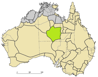
The Northern Territory is an Australian territory in the central and central northern regions of Australia. The Northern Territory shares its borders with Western Australia to the west, South Australia to the south, and Queensland to the east. To the north, the territory looks out to the Timor Sea, the Arafura Sea and the Gulf of Carpentaria, including Western New Guinea and other islands of the Indonesian archipelago.

Tjoritja /West MacDonnell is a national park in the Northern Territory (Australia) due west of Alice Springs and 1234 km south of Darwin. It extends along the MacDonnell Ranges west of Alice Springs.
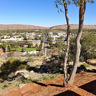
Alice Springs is the third-largest town in the Northern Territory of Australia. Known as Stuart until 31 August 1933, the name Alice Springs was given by surveyor William Whitfield Mills after Alice, Lady Todd, wife of the telegraph pioneer Sir Charles Todd. Known colloquially as The Alice or simply Alice, the town is situated roughly in Australia's geographic centre. It is nearly equidistant from Adelaide and Darwin.

Katherine is a town in the Northern Territory of Australia. It is situated on the Katherine River, after which it is named, 320 kilometres (200 mi) southeast of Darwin. It is the fourth largest settlement in the Territory and is known as the place where "The outback meets the tropics". Katherine had an urban population of approximately 6,300 at the 2016 Census.
The Finke River, or Larapinta (Arrernte), is a river in central Australia, one of four main rivers of the Lake Eyre Basin and thought to be the oldest riverbed in the world. It flows for only a few days a year and when this happens, its water usually disappears into the sands of the Simpson Desert, rarely if ever reaching Lake Eyre.

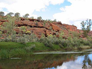
The Todd River is an ephemeral river in the southern Northern Territory, central Australia. The origins of the Todd River are in the MacDonnell Ranges, where it flows past the Telegraph Station, almost through the centre of Alice Springs, through Heavitree Gap at the southern end of Alice Springs and continuing on for some distance, passing through the western part of the Simpson Desert, as it becomes a tributary of the Hale River, and eventually flowing into Lake Eyre in South Australia.

Central Australia, also known as the Alice Springs Region, is one of the five regions in the Northern Territory of Australia. The term Central Australia is used to describe an area centred on Alice Springs. It is sometimes referred to as Centralia; likewise the people of the area are sometimes called Centralians. The region is located in the southern part of the Northern Territory spanning from the west on the Western Australian Border to the east on the Queensland border.

The MacDonnell Ranges, or Tjoritja in Arrernte, is a mountain range and an interim Australian bioregion located in southern Northern Territory and has an area of 3,929,444 hectares. The range is a 644 km (400 mi) long series of mountains in central Australia, consisting of parallel ridges running to the east and west of Alice Springs. The mountain range contains many spectacular gaps and gorges as well as areas of Aboriginal significance.

Jay Creek is in the MacDonnell Ranges 45 kilometres (28 mi) west of Alice Springs in the Northern Territory in Australia. It was a government reserve for Aboriginal Australians which for a time in the late 1920s and early 1930s included 45 children from a home named "The Bungalow"(37 of whom were under the age of 12) temporarily housed in a corrugated iron shed with a superintendent and matron housed separately in two tents.
Arrernte or Aranda or sometimes referred to as Upper Arrernte, is a dialect cluster in the Arandic language group spoken in parts of the Northern Territory, Australia, by the Arrernte people. Other spelling variations are Arunta or Arrarnta, and all of the dialects have multiple other names.

The Arrerntepeople, sometimes referred to as the Aranda, Arunta or Arrarnta, are a group of Aboriginal Australian peoples who live in the Arrernte lands, at Mparntwe and surrounding areas of the Central Australia region of the Northern Territory. Many still speak one of the various Arrernte dialects. Some Arrernte live in other areas far from their homeland, including the major Australian cities and overseas.
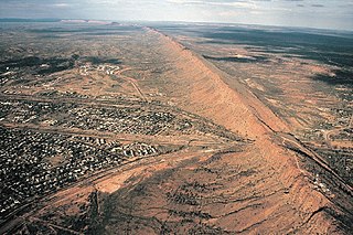
The Heavitree Gap, or Ntaripe in the Arrernte language, is a water gap in the Northern Territory of Australia in the MacDonnell Ranges. It is the southern entrance to the city of Alice Springs and in addition to the Todd River it carries the main road and rail access to the south.
The Alice Springs Town Council is a local government area in the Northern Territory. On 1 July 1971, Alice Springs was gazetted as a Municipality with the town council elected on 25 July 1971. It is situated 1,498 kilometres (931 mi) south of Darwin. The council governs an area of 328 square kilometres (127 sq mi) and had a population of 26,534 in June 2018.

Elliott is a town in Northern Territory of Australia. It is almost halfway between Darwin and Alice Springs on the Stuart Highway. The town is in the Yapurkulangu ward of the Barkly Region. The area is the home of the Jingili people and the traditional name of the town is Kulumindini. At the 2016 census, Elliott had a population of 339.

Hann Range is a mountain range in the Northern Territory of Australia located in central Australia approximately 120 kilometres (75 mi) north of Alice Springs.

ANZAC Hill, at 608 meters, is located in Alice Springs, in the Northern Territory of Australia.

The Alice Springs Telegraph Station is located within the Alice Springs Telegraph Station Historical Reserve, four kilometres north of the Alice Springs town centre in the Northern Territory of Australia. Established in 1872 to relay messages between Darwin and Adelaide, it is the original site of the first European settlement in central Australia. It was one of twelve stations along the Overland Telegraph Line.
Kilgariff is a suburb of Alice Springs located in the Northern Territory of Australia about 1,290 kilometres (800 mi) south of the territory capital of Darwin and about 7 kilometres (4.3 mi) south of the municipal seat in the Alice Springs central business district. Kilgariff is located within the federal division of Lingiari, the territory electoral division of Braitling and the local government area of the Town of Alice Springs.
Honeymoon Gap is a small gap south of Larapinta Drive, opposite Simpsons Gap, 20 km west of Alice Springs. It is located on Roe Creek.
Little Flower Mission operated from 1938 - 1942 and it was a mission to Eastern Arrernte people who were living in and around the township of Alice Springs. The mission was established by Catholic missionaries, part of the Missionaries of the Sacred Heart order.
References
- ↑ "Place Names Register". www.ntlis.nt.gov.au. Retrieved 24 November 2019.
- ↑ "AIATSIS Place Name Thesaurus - Results". www1.aiatsis.gov.au. Retrieved 24 November 2019.
- 1 2 Brooks, David, 1950- (2003). A town like Mparntwe : a guide to the dreaming tracks and sites of Alice Springs. Alice Springs, NT: Jukurrpa Books. ISBN 1-86465-045-1. OCLC 56211336.
{{cite book}}: CS1 maint: multiple names: authors list (link) - ↑ "Todd River" (PDF). Bureau of Meteorology. Archived (PDF) from the original on 2 April 2011.
- ↑ "Alice Springs, Northern Territory". spencerandgillen.net. Retrieved 3 November 2020.
River systems and rivers of the Northern Territory, Australia | |
|---|---|
| Floodplains | |
| Rivers |
|
23°41′29″S133°53′04″E / 23.6913°S 133.8845°E Coordinates: 23°41′29″S133°53′04″E / 23.6913°S 133.8845°E