Daly River (Northern Territory)

Last updated

Daly River
Daly River2.jpg
Australia Northern Territory relief location map.png
Red pog.svg
Etymology Dominick Daly
Location
CountryAustralia
Territory Northern Territory
Physical characteristics
Source 
  locationConfluence of Flora and Katherine river
  coordinates 14°39′22.9536″S131°42′18.0864″E / 14.656376000°S 131.705024000°E / -14.656376000; 131.705024000 -->
  elevation64 m (210 ft)
2nd source Katherine River
  location Arnhem Land
  coordinates 13°16′2.9784″S133°4′27.7608″E / 13.267494000°S 133.074378000°E / -13.267494000; 133.074378000
  elevation453 m (1,486 ft)
3rd sourceFlora River
  locationFlora River Nature Park
  coordinates 14°54′37.6884″S131°10′35.0328″E / 14.910469000°S 131.176398000°E / -14.910469000; 131.176398000
  elevation268 m (879 ft)
Mouth Timor Sea
  coordinates
13°20′S130°19′E / 13.333°S 130.317°E / -13.333; 130.317
  elevation
0 m (0 ft)
Length354 km (220 mi) [1]
Basin size53,708 km2 (20,737 sq mi) [1]
Discharge 
  location Timor Sea (near mouth)
  average369.7 m3/s (11,670 GL/a) [2]
Discharge 
  locationWooliana (92 rkm, 13°40′43.428″S130°38′36.6648″E / 13.67873000°S 130.643518000°E / -13.67873000; 130.643518000 ; Basin size: 49,898.4 km2 (19,265.9 sq mi)
  average317.8 m3/s (10,030 GL/a) [2]
Discharge 
  locationMount Nancar (113 rkm, 13°47′58.8624″S130°43′30.2448″E / 13.799684000°S 130.725068000°E / -13.799684000; 130.725068000 ; Basin size: 47,652 km2 (18,399 sq mi)
  average(Period: 2000-2022)315.3 m3/s (9,950 GL/a) [3]
  minimum11 m3/s (350 GL/a) (1970) [3]
  maximum8,293 m3/s (261,700 GL/a) (1998) [3]
Discharge 
  locationDorisvale Crossing (214 rkm, 14°21′47.8764″S131°33′23.9004″E / 14.363299000°S 131.556639000°E / -14.363299000; 131.556639000 ; Basin size: 33,227 km2 (12,829 sq mi)
  average(Period: 2000-2022)215.1 m3/s (6,790 GL/a) [4]
Basin features
Tributaries 
  leftFlora, Bradshaw Creek, Jinduckin Creek, Cattle Creek, Bamboo Creek, Fish, Chilling Creek, Hermit Creek
  right Katherine, Fergusson, Stray Creek, Douglas, Green Ant Creek, Hayward Creek, Kilfoyle Creek, Elliot Creek

The Daly River is a river in the Northern Territory of Australia. It is part of the Daly Catchment.

Contents

The Daly River flows 354 kilometres (220 mi) from the confluence of the Flora River and Katherine River to its mouth on the Timor Sea. [5] It is one the few major rivers in the Northern Territory that flows all year round. Sustained by groundwater, its dry-season flows are five time larger than any other river in the territory. [6]

It is home to more than 90 species of fish. It is best known for its large barramundi making it a popular waterway for recreational fishing. The floodwater carries baitfish which attracts predatory barramundi. The river is also home to the critically endangered largetooth sawfish. It also has eight different turtle species, includes the endangered pig-nosed turtle, more than any other Australian river. [7]

History

The traditional owners of the river and surrounding area are the Wadjigiynk, Maranunngu, Malak Malak, Kamu, Warai, Nanggiwumerri, Wagiman, Wardaman, Dagoman, Jawoyn, Matngala, and Yangman peoples. [6]

Boyle Travers Finniss named the river after Sir Dominick Daly, the Governor of South Australia, as the Northern Territory was at that time part of South Australia. [8] The region then lay untouched by Europeans until 1882 when copper was discovered.

Settlement on the river is centred on the Aboriginal community of Nauiyu, originally the site of a Catholic mission from 1955 to 1977, [9] as well as the town of Daly River itself, at the river crossing a few kilometres to the south. [10]

Industry

The Daly River Copper Mine was established after a rich copper lode was discovered at Mt Haywood along the Daly River in 1882. Woolwonga people killed four mine workers Johannes Noltenius, John Landers, Thomas Schollert and Henry Roberts on 3 September 1884. This triggered the Coppermine massacres led by the mine manager Sachse with police that saw over 150 people killed, decimating the Malak-Malak and Woolwonga people. [11] After a history of boom to bust and multiple lease turnovers the mine closed for good in 1925. [12]

The river also supports cattle, with the Daly River Cattle Station starting up in 1985, now Tipperary Station. [12]

The Daly River is popular location for tourism and recreational fishing due to its large barramundi. [13] It hosts two major fishing competitions annually, the "Barra Classic" and the "Barra Nationals". Both occur just after the wet season when the flooded river is falling fast, and clear water is pouring in off the floodplains which is thought to be the best time for fishing. [14] [15]

The Daly is also the site of a proposed large-scale cotton industry harvesting up to 500 gigalitres of flood waters. This would come under the Oolloo Dolostone Aquifer Water Allocation Plan that has already been overallocated by the Northern Territory Government. [16] [6] [17]

Floods

Like other rivers of the top end, the Daly is prone to seasonal flooding. Major flood events devastated the town of Daly River in 1899 and 1957, causing widespread property damage. The largest flood event post colonisation was in 1998, when floodwaters were fed by heavy rainfall in the wake of Tropical Cyclone Les reaching a peak of 16.25 m (53.3 ft) at the Daly River Police Station gauge, the highest level recorded to date. There were also flooding events triggering evacuations in 2000, 2018, 2023 and 2024. [18] [19]

Discharge

Mean annual discharge of the Daly River at Mount Nancar (period from 1971 to 2021) and Dorisvale Crossing (period from 1966 to 2021): [3] [4]

YearMean annual

discharge

Mean annual

discharge

Mount NancarDorisvale Crossing
(GL/yr)(m3/s)(GL/yr)(m3/s)
19663,953.86125.4
19674,183.33132.7
19687,990.78253.4
19696,112.79193.8
1970929.5429.5
19713,055.796.93,073.5297.5
19725,687.83180.43,632.47115.2
19737,839.22248.63,887.4123.3
197420,253.44642.212,401.14393.2
19757,484.03237.34,286.37135.9
197617,002.91539.212,267.05389
19776,421.06203.68,090.05256.5
19784,132.81131.14,190.23132.9
19794,177.21132.53,322.47105.4
19808,560.55271.55,620.36178.2
19817,574.83240.25,143.17163.1
19824,301.86136.43,422.13108.5
19832,311.6673.31,590.1850.4
198410,906.22345.88,151.43258.5
19854,565.57144.82,117.4767.2
19861,339.542.51,051.3333.3
19876,114.56193.95,165.54163.8
19881,516.7148.11,181.7637.5
19895,696.05180.62,710.7886
19901,054.5133.4694.3722
19919,506.28301.46,508.84206.4
19922,003.1663.51,371.843.5
19937,062.552244,457.08141.3
19946,562.66208.15,077.1161
19958,354.25264.94,596.53145.8
19962,199.7669.81,517.2248.1
199715,952.31505.810,723.82339.4
199813,449.46426.510,096.29320.2
199910,307.06326.87,188.43227.9
200014,335.51454.69,454.27299.8
200114,418.61457.210,884.56345.2
20027,672.74243.34,918.2156
20036,827.31216.56,738.52213.7
200420,593.8665316,682.53529
20053,987.72126.52,995.9995
200612,806.45406.19,772.37309.9
20076,547.18207.65,001.04158.6
200814,953.96474.29,298.98294.9
200913,365.59423.810,078.81319.6
20106,212.971974,630.84146.8
201123,694.11751.314,168.17449.3
20129,189.34291.45,610.28177.9
20135,863.01185.93,739.89118.6
20149,246.1293.25,027.72159.4
20153,739.96118.62,714.2786.1
20169,234.43292.85,722.1181.5
201710,920.68346.36,580.47208.7
201811,352.473605,925.41187.9
20191,843.0158.41,126.4935.7
20202,260.7571.71,002.6731.8
20219,704.87307.77,152.42226.8
Average8,316.95263.75,642178.9

Tributaries

List of major tributaries

The largest tributaries of the Daly River: [2] [20]

Left

tributary

Right

tributary

Length

(km)

Basin

size

(km2)

Average

discharge

(m3/s)

Daly354*53,708369.7
Hermit C.62.42,456.330.2
Elliot C.24.22.9
Kilfoyle C.15.9455.46.5
Chilling C.69.91,24112.4
Hayward Creek29.64725.8
Austral C.161
Survey C.15.6200.21.7
Fish 89.11,74820.5
Bamboo C.10.6627.46.1
Green Ant Creek48.891415
Douglas83.41,96421.8
Cattle C.17.5122.51.2
Jinduckin Creek35.2348.32.7
Stray C.641,2168.2
Brandshaw Creek63.51,1816.5
Dead Horse C.41.41.4
Fergusson1444,833.630.6
Yuwaiyunn Creek1.3
Yujullowan Creek29.1191.40.7
Mullers C.8.70.06
Flora1396,87627.2
Katherine 32824,363.3109.8

*Daly River 354 km (220 mi) with Flora River (139 km (86 mi) [20] is 493 km (306 mi) long; Daly River with the Katherine (328 km (204 mi) [20] is 682 km (424 mi) long;

See also

Related Research Articles

<span class="mw-page-title-main">Darwin, Northern Territory</span> Capital city of Northern Territory, Australia

Darwin is the capital city of the Northern Territory, Australia. With a population of 139,902 at the 2021 census, the city contains most of the sparsely populated Northern Territory's residents. It is the smallest, wettest, and most northerly of the Australian capital cities and serves as the Top End's regional centre.

<span class="mw-page-title-main">Northern Territory</span> Territory of Australia

The Northern Territory is an Australian territory in the central and central northern regions of Australia. The Northern Territory shares its borders with Western Australia to the west, South Australia to the south, and Queensland to the east. To the north, the territory looks out to the Timor Sea, the Arafura Sea and the Gulf of Carpentaria, including Western New Guinea and other islands of the Indonesian archipelago.

<span class="mw-page-title-main">Protected areas of the Northern Territory</span>

The protected areas of the Northern Territory consists of protected areas managed by the governments of the Northern Territory and Australia and private organisations with a reported total area of 335,527 square kilometres (129,548 sq mi) being 24.8% of the total area of the Northern Territory of Australia.

Litchfield National Park, covering approximately 1500 km2, is near the township of Batchelor, 100 km south-west of Darwin, in the Northern Territory of Australia. Each year the park attracts over 260,000 visitors.

<span class="mw-page-title-main">Katherine, Northern Territory</span> Town in the Northern Territory, Australia

Katherine is a town in the Northern Territory of Australia. It is situated on the Katherine River, after which it is named, 320 kilometres (200 mi) southeast of Darwin. The fourth largest settlement in the Territory, it is known as the place where "The outback meets the tropics". Katherine had an urban population of approximately 6,300 at the 2016 Census.

<span class="mw-page-title-main">Alligator Rivers</span> River delta in northern Australia

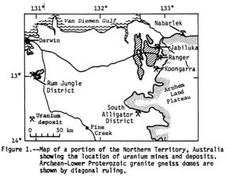
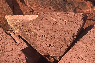
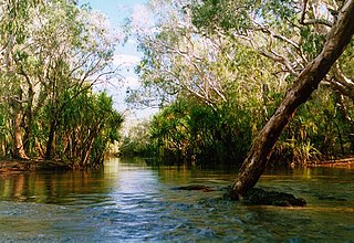
Alligator Rivers is the name of an area in an Arnhem Land region of the Northern Territory of Australia, containing three rivers, the East, West, and South Alligator Rivers. It is regarded as one of the richest biological regions in Australia, with part of the region in the Kakadu National Park. It is an Important Bird Area (IBA), lying to the east of the Adelaide and Mary River Floodplains IBA. It also contains mineral deposits, especially uranium, and the Ranger Uranium Mine is located there. The area is also rich in Australian Aboriginal art, with 1500 sites. The Kakadu National Park is one of the few World Heritage sites on the list because of both its natural and human heritage values. They were explored by Lieutenant Phillip Parker King in 1820, who named them in the mistaken belief that the crocodiles in the estuaries were alligators.

<span class="mw-page-title-main">Kalkarindji</span> Aboriginal settlement in the Victoria Daly Region, Northern Territory, Australia

Kalkarindji is a town and locality in the Northern Territory of Australia, located on the Buntine Highway about 554 kilometres (344 mi) south of the territory capital of Darwin and located about 460 kilometres (290 mi) south of the municipal seat in Katherine.

Mataranka is a town and locality in the Northern Territory of Australia located about 420 km (260 mi.) southeast of the territory capital of Darwin, and 107 km (66 mi.) south of Katherine. At the 2016 census, Mataranka recorded a population of 350. 29.5% of residents are Aboriginal and/or Torres Strait Islander.

<span class="mw-page-title-main">Daly River, Northern Territory</span> Town in the Northern Territory, Australia

Daly River is a town adjacent to the Daly River in the Northern Territory of Australia. At the 2006 census, Daly River had a population of 468. The town is part of the Victoria Daly Region local government area. The area is popular for recreational fishing, being regarded as one of the best places to catch Barramundi in Australia.

<span class="mw-page-title-main">Roper River</span> River in Northern Territory, Australia

The Roper River is a large perennial river located in the Katherine region of the Northern Territory of Australia.

<span class="mw-page-title-main">Cyclone Les</span>

Tropical Cyclone Les was a Category 2 storm in the 1997–98 Australian region cyclone season, which affected the Northern Territory of Australia in January 1998.

<span class="mw-page-title-main">Mary River (Northern Territory)</span> River in Northern Territory, Australia

The Mary River flows in the Northern Territory of Australia and is a site of the Mary River National Park.

Timber Creek, traditionally known as Makalamayi, is an isolated small town on the banks of the Victoria River in the Northern Territory of Australia. The Victoria Highway passes through the town, which is the only significant settlement between the Western Australia border and the town of Katherine to the east. Timber Creek is approximately 600 kilometres (370 mi) south of Darwin, in an area known for its scenic escarpments and boab trees.

Daguragu, previously also known as Wattie Creek by the Gurindji people as it is situated on a tributary of the Victoria River, is a locality in the Northern Territory of Australia. It is located about 551 kilometres (342 mi) south of the territory capital of Darwin and located about 460 kilometres (290 mi) south-west of the municipal seat in Katherine. It is around 8 km (5.0 mi) north-west of Kalkarindji. Daguragu community is situated on Aboriginal land held under perpetual title; it was also formerly a local government area until its amalgamation into the Victoria Daly Shire on 1 July 2008.

Fish River Station is a protected area approximately 50 km (31 mi) south of Daly River and 150 kilometres (93 mi) south of Darwin in the Northern Territory of Australia.

<span class="mw-page-title-main">Finniss River (Northern Territory)</span> River in Northern Territory, Australia

The Finniss River is a river south of Darwin, running west from the flank of Mount Minza, passing north of Litchfield National Park and flowing into the sea at Fog Bay. The East Branch of the Finniss was heavily polluted during the 1970s due to uranium mining at Rum Jungle mine about 105 km south of Darwin. The Finniss River Land Claim was presented to Judge John Toohey in 1981 but the former Rum Jungle mine site, contained within Area 4 of the Finniss River Land Claim (1981) was excluded from the grant to the Finniss River Land Trust due to the concerns of the Kungarakany and Warai peoples who are joint traditional Aboriginal owners of that area.

<span class="mw-page-title-main">Goyder River</span> River in the Northern Territory of Australia

The Goyder River is a river in the Northern Territory of Australia.

The Settlement Creek is a creek in the Northern Territory and the state of Queensland, Australia.

The Wulwulam, also known as the Woolwonga, were an indigenous Australian people of the Northern Territory. They are reputed to have been almost completely exterminated in the 1880s in reprisal for an incident in which some members of the tribe speared 4 miners.

The COVID-19 pandemic in the Northern Territory is part of the ongoing worldwide pandemic of the coronavirus disease 2019 caused by severe acute respiratory syndrome coronavirus 2.

References

  1. 1 2 "Daly: Geographic information".
  2. 1 2 3 "Darwin-Arnhem".
  3. 1 2 3 4 "Hydrologic Reference Stations-Mount Nancar".
  4. 1 2 "Hydrologic Reference Stations-Dorisvale Crossing".
  5. McLennan, Chris (19 September 2018). "Katherine's poison plume". Katherine Times . Retrieved 29 March 2021.
  6. 1 2 3 Booth, Carol; Turner, Joel (February 2024). "Free-flowing Rivers of Australia's North". Territory Rivers: Keep ‘em Flowing.{{cite web}}: Missing or empty |url= (help)
  7. Warren Snowdon (6 October 2011). "Fish River - Conservation helps close the gap". Media Release. Commonwealth of Australia. Retrieved 3 November 2011.
  8. "Place Names Register". www.ntlis.nt.gov.au. Retrieved 26 April 2024.
  9. Find & Connect Web Resource Project, The University of Melbourne and Australian Catholic University. "Daly River Mission - Organisation - Find & Connect - Northern Territory". www.findandconnect.gov.au. Retrieved 26 April 2024.
  10. "Nauiyu / Daly River". Victoria Daly Regional Council. Retrieved 26 April 2024.
  11. "Centre For 21st Century Humanities". c21ch.newcastle.edu.au. Retrieved 26 April 2024.
  12. 1 2 "Daly River (1886-1899) | German Missionaries in Australia". missionaries.griffith.edu.au. Retrieved 26 April 2024.
  13. "Daly River". Territory Rivers. 25 June 2021. Retrieved 26 April 2024.
  14. "Low rain leaves mark on iconic NT fishing comp". www.9news.com.au. 2 May 2019. Retrieved 26 April 2024.
  15. Uvert, Tiina (1 May 2017). "Barra Nationals wrap up on Daly River with 894 fish caught". NT News.
  16. "Expanded 2020 Cotton Trial - Tipperary Group" . Retrieved 26 April 2024.
  17. "Cotton in the Northern Territory Facts and Stats" (PDF). Department of Industry, Tourism and Trade. Northern Territory Government.
  18. Paiva, Jerome (March 2000). "Daly River Community Flood Study". Lands Planning Einvornment. Northern Territory Government. Retrieved 26 April 2024.
  19. "Man missing in Daly River floodwaters; emergency declared for NT community". www.willyweather.com.au. Retrieved 26 April 2024.
  20. 1 2 3 "Map of Daly River in the Northern Territory".