McArthur River

Last updated

McArthur
McArthur River.jpg
McArthur River at Borroloola, 2011
Australia Northern Territory relief location map.png
Red pog.svg
Location in Northern Territory, Australia
Etymology James McArthur
Location
Country Australia
Territory Northern Territory
Region Katherine Region
Physical characteristics
Source Barkly Tableland
  locationeast of Elliott
  elevation234 m (768 ft)
Mouth Gulf of Carpentaria
  location
east of Borroloola
  coordinates
15°54′S136°40′E / 15.900°S 136.667°E / -15.900; 136.667 Coordinates: 15°54′S136°40′E / 15.900°S 136.667°E / -15.900; 136.667
  elevation
0 m (0 ft)
Length521 km (324 mi)
Basin size20,010 km2 (7,730 sq mi)
Discharge 
  average103.6 m3/s (3,660 cu ft/s)
[1]

The McArthur River is a river in the Northern Territory of Australia which flows into the Gulf of Carpentaria at Port McArthur, opposite the Sir Edward Pellew Group of Islands. The river was named by Ludwig Leichhardt while he explored the area in 1845. [2] He named the River after James MacArthur and the MacArthur family of Camden, who were enthusiastic supporters of his expedition. [3] The McArthur River has significance for the local Aboriginal communities, who use it for fishing and other traditional activities. [4]

Contents

Description

The McArthur River basin covers 20,010 km2 (7,726 sq mi). [5] [6] The basin is situated between the Rosie River catchment to the north, the Limmen Bight River to the east, the Barkly River catchment to the south and the Robinson River catchment to the west. The mean annual runoff is 3,270,000  ML (115,000×10^6 cu ft) per year. [7] The headwaters of the rivers rise on the northern edge of the Barkly Tableland. Tributaries of the McArthur River include Tooganginie Creek, and the Kilgour and Clyde rivers.

The river has a long tidal estuary which extends inland to the town of Borroloola. The estuary is in near-pristine condition, [8] and forms part of the Port McArthur Tidal Wetlands System Important Bird Area. [9]

McArthur River zinc mine expansion

In 2007, plans to expand the McArthur River zinc mine, one of the world's largest zinc mines, were halted by a decision of the Supreme Court of the Northern Territory. It was found that the approval of the expansion by Mines Minister Chris Natt was invalid. [10] Traditional owners were concerned the proposal, which included a 5.5 km (3.4 mi) river diversion, had serious, long term and irreversible impacts. [11]

In 2008, the case was heard by the Federal Court, which found that the expansion was illegal. [12] In early 2009, the Federal Environment Minister Peter Garrett formally approved the mine's expansion. [4] [13] Garrett placed conditions on the project which aimed to reduce the impact on the freshwater sawfish and migratory birds. [4]

See also

Related Research Articles

<span class="mw-page-title-main">Gulf of Carpentaria</span> Gulf of Australia

The Gulf of Carpentaria is a large, shallow sea enclosed on three sides by northern Australia and bounded on the north by the eastern Arafura Sea. The northern boundary is generally defined as a line from Slade Point, Queensland in the northeast, to Cape Arnhem on the Gove Peninsula, Northern Territory in the west.

<span class="mw-page-title-main">Clyde River (New South Wales)</span> River in Australia

The Clyde River is an open intermediate tide dominated drowned valley estuary, or perennial river that flows into the Tasman Sea at Batemans Bay, located in the South Coast region of New South Wales, Australia.

<span class="mw-page-title-main">Mitchell River (Queensland)</span> River in Queensland, Australia

The Mitchell River is a river located in Far North Queensland, Australia. The river rises on the Atherton Tableland about 50 kilometres (31 mi) northwest of Cairns and flows about 750 kilometres (470 mi) northwest across Cape York Peninsula from Mareeba to the Gulf of Carpentaria.

<span class="mw-page-title-main">Calliope River</span> River in Queensland, Australia

The Calliope River is a river located in Central Queensland, Australia.

<span class="mw-page-title-main">Port Hacking</span> Estuary in southern Sydney, Australia

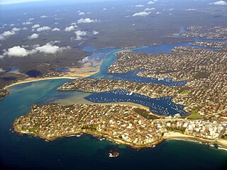
Port Hacking Estuary, an open youthful tide dominated, drowned valley estuary, is located in southern Sydney, New South Wales, Australia approximately 30 kilometres (19 mi) south of Sydney central business district. Port Hacking has its source in the upper reaches of the Hacking River south of Helensburgh, and several smaller creeks, including South West Arm, Bundeena Creek and The Basin and flows generally to the east before reaching its mouth, the Tasman Sea, south of Cronulla and north–east of Bundeena. Its tidal effect is terminated at the weir at Audley, in the Royal National Park. The lower estuary features a substantial marine delta, which over time has prograded upstream. There is also a substantial fluvial of the Hacking River at Grays Point. The two deltas are separated by a deep basin.

<span class="mw-page-title-main">Borroloola</span> Town in the Northern Territory, Australia

Borroloola is a town in the Northern Territory of Australia. It is located on the McArthur River, about 50 km upstream from the Gulf of Carpentaria.

<span class="mw-page-title-main">Coomera River</span> River in Queensland, Australia

The Coomera River is a perennial river located in the South East region of Queensland, Australia. Its catchment lies within the Gold Coast and Scenic Rim Region local government areas and covers an area of 489 square kilometres (189 sq mi).

<span class="mw-page-title-main">Peel-Harvey Estuarine System</span> Estuarine system south of Mandurah, Western Australia

The Peel-Harvey Estuarine System is a natural estuarine system that lies roughly parallel to the coast of Western Australia and south of the town of Mandurah.

<span class="mw-page-title-main">McArthur River zinc mine</span> Mine in Northern Territory, Australia

The McArthur River mine is a zinc-lead mine, situated about 70 kilometres southwest of Borroloola, near the Gulf of Carpentaria in the northeastern Northern Territory, Australia. It is operated by McArthur River Mining (MRM), a subsidiary of the Swiss mining company Glencore. Although discovered in the 1950s, when it was originally called the HYC or "Here's Your Chance" deposit, it only opened as a mine in 1995. Initially an underground mining operation, the mine has been converted to open-cut.

<span class="mw-page-title-main">Mary River (Northern Territory)</span> River in Northern Territory, Australia

The Mary River flows in the Northern Territory of Australia and is a site of the Mary River National Park.

<span class="mw-page-title-main">Gulf Country</span> Region in Queensland, Australia

The Gulf Country is the region of woodland and savanna grassland surrounding the Gulf of Carpentaria in north western Queensland and eastern Northern Territory on the north coast of Australia. The region is also called the Gulf Savannah. It contains large reserves of zinc, lead and silver. The Gulf Country is crossed by the Savannah Way highway.

The Fitzmaurice River is a river in Australia's Northern Territory.

The Calvert River is a river in the Northern Territory of Australia.

<span class="mw-page-title-main">Leichhardt River</span> River in Queensland, Australia

The Leichhardt River is a river in north west Queensland, Australia.

Blackmore River flows into Darwin Harbour close to Darwin in the Northern Territory of Australia.

Liverpool River is a river in the Northern Territory of Australia. It is the largest of the tidal river systems of northern Arnhem Land, which includes two major tributaries, the Tomkinson and Mann Rivers.

The Blyth River is a river in the Northern Territory, Australia.

The Moyle River is a river in the Northern Territory, Australia.

<span class="mw-page-title-main">Towns River</span> River in Northern Territory, Australia

The Towns River is a river in the Northern Territory, Australia.

The Robinson River is a river in Australia's Northern Territory.

References

  1. "Map of McArthur River, NT". Bonzle Digital Atlas of Australia. Retrieved 11 December 2015.
  2. "Borroloola". The Sydney Morning Herald. Fairfax Media. 8 February 2004. Retrieved 19 August 2011.
  3. "Place Names Register Extract - Mcarthur River River". NT Place Names Register. Northern Territory Government . Retrieved 17 May 2015.
  4. 1 2 3 "Garrett approves MRM zinc mine expansion". The Sydney Morning Herald. Fairfax Media. 20 February 2009. Retrieved 19 August 2011.
  5. "Landscape - carbon, nutrients, water and productivity - McArthur River". Australian Natural Resources Atlas. Department of Sustainability, Environment, Water, Population and Communities. 6 May 2009. Archived from the original on 2 June 2011. Retrieved 19 August 2011.
  6. "Drainage Divisions" (PDF). Commonwealth of Australia. 2005. Archived from the original (PDF) on 1 April 2015. Retrieved 18 May 2015.
  7. "Water resources - Availability - Northern Territory". Australian Natural Resources Atlas. Department of Sustainability, Environment, Water, Population and Communities. 13 May 2009. Archived from the original on 2 June 2011. Retrieved 19 August 2011.
  8. "Estuary Assessment 2000: Basin: McArthur River". Australian Natural Resources Atlas. Department of Sustainability, Environment, Water, Population and Communities. 20 June 2009. Archived from the original on 2 June 2011. Retrieved 19 August 2011.
  9. BirdLife International. (2011). Important Bird Areas factsheet: Port McArthur Tidal Wetlands System. Downloaded from "BirdLife International - conserving the world's birds". Archived from the original on 10 July 2007. Retrieved 18 November 2012. on 22/09/2011.
  10. "McArthur River mine expansion 'invalid'". ABC News. Australian Broadcasting Corporation. 30 April 2007. Retrieved 19 August 2011.
  11. "Current Campaigns » Mining » McArthur River". The Environment Centre of the Northern Territory. Archived from the original on 3 September 2011. Retrieved 19 August 2011.
  12. "Territory Govt seeks action on McArthur River Mine". ABC News. Australian Broadcasting Corporation. 18 December 2008. Retrieved 19 August 2011.
  13. "McArthur River Mine expansion gets green light". ABC News. Australian Broadcasting Corporation. 20 February 2009. Retrieved 19 August 2011.