Caboolture River

Last updated

Caboolture
StateLibQld 1 157653 Railway Bridge over the Caboolture River, 1907.jpg
Railway Bridge over the Caboolture River, 1907
Australia Queensland relief location map.jpg
Red pog.svg
Location of the Caboolture River mouth in Queensland
Etymology Kabi Yugarabul dialect: Derived Kabultur to Caboolture, meaning "place of the carpet snake". [1]
Location
Country Australia
State Queensland
Region South East Queensland
Local government area Moreton Bay Region
City Caboolture
Physical characteristics
Source D'Aguilar Range
  locationbelow Campbells Pocket
  coordinates 27°7′32″S152°48′20″E / 27.12556°S 152.80556°E / -27.12556; 152.80556
  elevation262 m (860 ft)
Mouth Deception Bay, Moreton Bay
  location
south of Beachmere
  coordinates
27°09′09″S153°02′48″E / 27.15250°S 153.04667°E / -27.15250; 153.04667
  elevation
0 m (0 ft)
Length46 km (29 mi)
Basin size468 km2 (181 sq mi)
Basin features
Tributaries 
  leftWararba Creek, Lagoon Creek
National park D'Aguilar National Park
[2] [3]

The Caboolture River is a small river in South East Queensland, Australia.

Contents

Location and features

View from train crossing, 2014 Caboolture River looking E from train.jpg
View from train crossing, 2014

Formed by runoff from the D'Aguilar Range, the Caboolture River rises below Campbells Pocket near Ocean View and flows generally east, joined by two minor tributaries and flowing through Rocksberg, Caboolture and Morayfield before entering Deception Bay, part of Moreton Bay, south of Beachmere. The river descends 262 metres (860 ft) over its 46-kilometre (29 mi) course. [2] [3]

The catchment area covers 468 square kilometres (181 sq mi). [4] There are no dams on the waterway, except for a weir and the only major crossing is the Bruce Highway bridge. The Caboolture River is tidal for 19 kilometres (12 mi) upstream to the Caboolture Weir. [5] At the river mouth a sand bar reduces the impact of tidal energy. [6]

Increased urbanisation in the catchment is posing a significant environmental threat to the river, particularly land clearing which is fragmenting pockets of forest. [5] In the upper reaches this has led to stormwater and sewerage runoff that has created significant nutrient and sediment loads. [6] Except for mangrove forests near the river's mouth most of the riparian vegetation has been cleared. An upgrade at the Caboolture Sewerage Treatment plant has reduced some pollution impacts. [6]

Upper parts of the catchment are protected with the D'Aguilar National Park. [4] Lower parts of the river are within the Moreton Bay Marine Park. [7]

Together with the Pine River and its tributaries, the Caboolture River is subject to episodes of flash flooding which can cause significant damage to public and private property throughout the catchment. Significant flood events with major flooding were reported in 1967, 1972, 1974, 1989, 1991, 2010, 2011, 2013 and 2015. [8]

History

The Kabi indigenous people are the traditional custodians of the Caboolture River catchment area. The name Kabultur is derived from the Yugarabul dialect meaning "place of the carpet snake". [1] The Kabi people harvested bush food, fresh water mussels, oysters, fish, and some game animals, moving around the land to take best advantage of seasonally-available produce.

Because of the numerous shoals at its mouth the explorer John Oxley originally named the waterway the Deception River in 1823. [9] The Caboolture River has been used to transport red cedar timber via raft from Mount Mee to Deception Bay. [5]

See also

Related Research Articles

<span class="mw-page-title-main">Brisbane River</span> River in Queensland, Australia

The Brisbane River is the longest river in South East Queensland, Australia, and flows through the city of Brisbane, before emptying into Moreton Bay on the Coral Sea. John Oxley, the first European to explore the river, named it after the Governor of New South Wales, Sir Thomas Brisbane in 1823. The penal colony of Moreton Bay later adopted the same name, eventually becoming the present city of Brisbane. The river is a tidal estuary and the water is brackish from its mouth through the majority of the Brisbane metropolitan area westward to the Mount Crosby Weir. The river is wide and navigable throughout the Brisbane metropolitan area.

<span class="mw-page-title-main">Moreton Bay</span> Inlet in southern Queensland, Australia

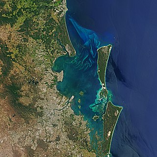
Moreton Bay is a bay located on the eastern coast of Australia 14 kilometres (8.7 mi) from central Brisbane, Queensland. It is one of Queensland's most important coastal resources. The waters of Moreton Bay are a popular destination for recreational anglers and are used by commercial operators who provide seafood to market.

<span class="mw-page-title-main">Logan River</span> River in Queensland, Australia

The Logan River is a perennial river in the Scenic Rim, Logan and Gold Coast local government areas of the South East region of Queensland, Australia. The 184-kilometre (114 mi)-long river is one of the dominant waterways in South East Queensland that drains the southern ranges of the Scenic Rim and empties into Moreton Bay after navigating the City of Logan, a major suburban centre located south of Brisbane. The catchment is dominated by urban and agricultural land use. Near the river mouth are mangrove forests and a number of aquaculture farms.

<span class="mw-page-title-main">Shire of Pine Rivers</span> Local government area in Queensland

The Shire of Pine Rivers was a local government area about 20 kilometres (12 mi) north of Brisbane in the Moreton Bay region of South East Queensland, Australia. The shire covered an area of 771 square kilometres (297.7 sq mi), and existed as a local government entity from 1888 until 2008, when it amalgamated with councils further north and east to form the Moreton Bay Region.

<span class="mw-page-title-main">Bremer River (Queensland)</span> River in Queensland, Australia

The Bremer River is a river that is a tributary of the Brisbane River, located in the Scenic Rim and Brisbane regions of South East Queensland, Australia. The 100-kilometre (62 mi)-long Bremer River drains several Scenic Rim valleys in south-east Queensland, including the Fassifern Valley, with its catchment area covering approximately 2,032 square kilometres (785 sq mi). Most valleys within the catchment have extensive river terraces. The Bremer River system is extremely degraded.

<span class="mw-page-title-main">South Pine River</span> River in Queensland, Australia

The South Pine River is a minor river in South East Queensland, Australia. It rises on the D'Aguilar Range and passes through the Samford Valley in the Moreton Bay Region local government area.

<span class="mw-page-title-main">Oxley Creek</span> River in Queensland, Australia

The Oxley Creek is a creek that is a tributary of the Brisbane River, located in suburban Brisbane in the South East region of Queensland, Australia.

<span class="mw-page-title-main">Lockyer Creek</span> River in Queensland, Australia

The Lockyer Creek is a creek in South East Queensland, Australia. A tributary of the Brisbane River, the creek is a major drainage system in the Lockyer Valley. Rising on the eastern slopes of the Great Dividing Range, the creek flows generally north-easterly for more than 100 kilometres (62 mi) before it reaches its confluence with the Brisbane River north-northeast of Lowood, and downstream from the Wivenhoe Dam. The creek is named after Edmund Lockyer.

<span class="mw-page-title-main">Mary River (Queensland)</span> River in Queensland, Australia

The Mary River is a major river system in the South East and Wide Bay–Burnett regions of Queensland, Australia.

<span class="mw-page-title-main">Bramble Bay</span> River in Queensland, Australia

Bramble Bay is an embayment of Moreton Bay in South East Queensland, Australia. The Brisway map reference is 12 H5, or see page 91 G19 in Refidex.

<span class="mw-page-title-main">North Pine River</span> River in Queensland, Australia

The North Pine River is a minor river in South East Queensland, Australia.

<span class="mw-page-title-main">City of Redcliffe</span> Local government area in Queensland, Australia

The City of Redcliffe is a former local government area in South East Queensland, Australia. In 2008 it was amalgamated with the Shires of Pine Rivers and Caboolture to create Moreton Bay Region. It is in the northern part of the County of Stanley, with a total area of 38.1 km² and a population of 51,174.

<span class="mw-page-title-main">Kedron Brook</span> River in Queensland, Australia

The Kedron Brook is a creek that flows through the northern suburbs of Brisbane in the south-east region of Queensland, Australia.

<span class="mw-page-title-main">Moreton Bay Region</span> Local government area in Queensland, Australia

The Moreton Bay Region is a local government area in the north of the Brisbane metropolitan city in South East Queensland, Australia. Established in 2008, it replaced three established local government areas, the City of Redcliffe and the Shires of Pine Rivers and Caboolture.

<span class="mw-page-title-main">Somerset Region</span> Local government area in Queensland, Australia

The Somerset Region is a local government area located in the West Moreton region of South East Queensland, Australia, about 100 kilometres (62 mi) northwest of Brisbane and centred on the town of Esk. It was created in 2008 from a merger of the Shire of Esk and the Shire of Kilcoy. It is commonly known as the Brisbane Valley, due to the Brisbane River which courses through the region, although significant parts of the region lie outside the hydrological Brisbane Valley itself.

Lake Manchester Dam is a concrete gravity dam with an un-gated spillway across Cabbage Tree Creek. It is also known as Cabbage Tree Creek Dam. It is in the locality of Lake Manchester, City of Brisbane, Queensland, Australia. The main purpose of the dam is for potable water supply of Brisbane. The impounded reservoir is called Lake Manchester.

<span class="mw-page-title-main">Norman Creek (Queensland)</span> River in Queensland, Australia

Norman Creek is a small tributary of the Brisbane River. The headwaters of the creek are located on the northern slopes of Toohey Mountain and Mount Gravatt in southern Brisbane, Queensland, Australia. The name derives from a corruption of Gorman's Creek, after Lieutenant Gorman, of H. M. 8th Foot - the last commandant at Moreton Bay.

Burpengary Creek is a tidal creek in Moreton Bay Region, Queensland, Australia. It has a total catchment area of 7,960 hectares. It is about 40 kilometres north of Brisbane,

<span class="mw-page-title-main">Moodlu, Queensland</span> Suburb of Moreton Bay Region, Queensland, Australia

Moodlu is a rural locality in the Moreton Bay Region, Queensland, Australia. In the 2016 census, Moodlu had a population of 318 people.

<span class="mw-page-title-main">Geography of Brisbane</span> Geography of the city of Brisbane in Queensland, Australia

The Geography of Brisbane is characterised by its coastal location in the south eastern corner of the Queensland state of Australia. It is located precisely halfway up the Australian east coast with longitudinal and latitudinal coordinates of 27.5° south and 153° east. The city resides within the Moreton Bay Floodplain, stretching from Caboolture to the north, Beenleigh to the south and as far as Ipswich to the west whilst being bordered by the Pacific Ocean to the east.

References

  1. 1 2 South East Queensland - Place Names Archived 2006-08-21 at the Wayback Machine 2 January 2006
  2. 1 2 "Map of Caboolture River, QLD". Bonzle Digital Atlas of Australia. Retrieved 7 October 2015.
  3. 1 2 "Caboolture River" (PDF). Care for our catchment series. Caboolture Shire Council. February 2007. Archived from the original (PDF) on 15 February 2012. Retrieved 7 October 2015.
  4. 1 2 "Caboolture River Catchment and Estuary". Healthy Waterways. Moreton Bay Waterways and Catchment Partnership. 2008. Archived from the original on 6 October 2010. Retrieved 8 September 2010.
  5. 1 2 3 "Caboolture River Brochure" (PDF). Care For Our Catchments Series. Caboolture Shire Council. Archived from the original (pdf) on 30 June 2009. Retrieved 22 June 2009.
  6. 1 2 3 Dennison, William C.; Eva G. Abal (1999). Moreton Bay Study: A Scientific Basis for the Healthy Waterways Campaign. Brisbane: South East Queensland Regional Water Quality Management Strategy Team. pp. 182–183. ISBN   0-9586368-1-8.
  7. Clark, Dea (4 March 2021). "Concerns Burpengary housing and marina development north of Brisbane will harm endangered wildlife". abc.net.au. ABC News. Retrieved 25 October 2021.
  8. "Flood System for the Pine and Caboolture Rivers". Rainfall & River Conditions. Bureau of Meteorology, Australian Government. June 2015. Retrieved 7 October 2015.
  9. "Deception Bay". Encyclopædia Britannica. Encyclopædia Britannica Online. Retrieved 23 June 2009.