Bowen River (Queensland)

Last updated

Bowen
Bowen River Weir.jpg
Bowen River Weir, 2010
Australia Queensland relief location map.jpg
Red pog.svg
Location of Bowen River mouth in Queensland
Etymology Sir George Bowen [1]
Location
Country Australia
State Queensland
Region North Queensland
Physical characteristics
SourceNormanby Range, Great Dividing Range
  locationnear Turrawulla
  coordinates 21°09′27″S148°13′59″E / 21.15750°S 148.23306°E / -21.15750; 148.23306
  elevation260 m (850 ft)
Source confluenceBroken River and Little Bowen River
  coordinates 20°48′39″S148°05′00″E / 20.81083°S 148.08333°E / -20.81083; 148.08333
  elevation148 m (486 ft)
Mouth Burdekin River
  location
south southeast of Ravenswood
  coordinates
20°23′40″S147°20′55″E / 20.39444°S 147.34861°E / -20.39444; 147.34861
  elevation
50 m (160 ft)
Length129 km (80 mi)
Basin size9,452 km2 (3,649 sq mi)
Basin features
River system Burdekin River
Tributaries 
  leftRosella Creek, Parrot Creek, Ten Mile Creek (Queensland), Oaky Creek (Queensland), Sandalwood Creek
  rightFlagstaff Creek, Basin Creek, Jack Creek (Queensland), Twelve Mile Creek (Queensland), Pelican Creek (Queensland)
[2]

The Bowen River is a river in North Queensland, Australia.

Contents

Course and features

Formed by the confluence of the Broken River and the Little Bowen River near Tent Hill in the Normanby Range, part of the Great Dividing Range, the Bowen River flows in a north-westerly direction along the base of the range then flows west across Emu Plains and is crossed by the Bowen Developmental Road just north of Havilah. The river then flows north-west again between the Herbert Range and Leichhardt Range then discharges into the Burdekin River, south southeast of Ravenswood. The river descends 98 metres (322 ft) over its 129-kilometre (80 mi) course. [2]

The catchment area of the river occupies 9,452 square kilometres (3,649 sq mi) of which an area of 236 square kilometres (91 sq mi) is composed of riverine wetlands. [3] The catchment is in poor condition with much of the riparian habitat having been cleared and prone to erosion. The area is mostly used for cattle grazing with the towns of Collinsville and Glendon both drawing their town water supply from the Bowen River Weir. The river has a mean annual discharge of 1,618 gigalitres (3.56×10¹¹ imp gal; 4.27×10¹¹ US gal). [4]

The Bowen River Weir supplies water to a coal mine, power station and the township of Collinsville. [5]

History

Bowen boating party, 1910s StateLibQld 1 199687 Boating party at Bowen, 1910-1920.jpg
Bowen boating party, 1910s

The river was named in 1861 by the Queensland Government, derived from the name of the town Bowen which was named in honour of Sir George Bowen, a Governor of Queensland. [1]

In the 1860s, Richard Daintree made mineral discoveries along the river. [6] Daintree made the first systematic examination of the Bowen River coal seams near Collinsville. [7]

Circa 1865, the Bowen River Hotel was built at the top of a steep bank of the river ( 20°32′02″S147°33′22″E / 20.534°S 147.5562°E / -20.534; 147.5562 (Bowen River Hotel) ). The hotel is now listed on the Queensland Heritage Register. [8]

Construction of the Bowen River Weir commenced in April 1982 and was completed in August 1983. The A$6.5 million project is situated approximately 25 kilometres (16 mi) south of Collinsville and delivers water to the Newlands Coal Mine. [9]

See also

Related Research Articles

<span class="mw-page-title-main">Fitzroy River (Queensland)</span> River in Queensland, Australia

The Fitzroy River is a river in Central Queensland, Australia. Its catchment covers an area of 142,665 square kilometres (55,083 sq mi), making it the largest river catchment flowing to the eastern coast of Australia. It is also the largest river basin that discharges onto the Great Barrier Reef.

<span class="mw-page-title-main">Burdekin River</span> River in Queensland, Australia

The Burdekin River is a river in North and Far North Queensland, Australia. The river rises on the northern slopes of Boulder Mountain at Valley of Lagoons, part of the western slope of the Seaview Range, and flows into the Coral Sea at Upstart Bay over 200 kilometres (124 mi) to the southeast of the source, with a catchment area of approximately 130,000 square kilometres (50,000 sq mi). The Burdekin River is Australia's largest river by (peak) discharge volume.

<span class="mw-page-title-main">Condamine River</span> River in Queensland, Australia

The Condamine River, part of the Balonne catchment that is part of the Murray-Darling Basin, drains the northern portion of the Darling Downs, an area of sub-coastal southern Queensland, Australia. The river is approximately 500 kilometers (310 mi) long and rises on Mount Superbus, South East Queensland's highest peak, on the western slopes of the Great Dividing Range, approximately 100 kilometres (62 mi) from the east coast of Queensland, and then flows north west across the Darling Downs, then west. The Condamine River is a tributary of the Darling River.

<span class="mw-page-title-main">Balonne River</span> River in Queensland, Australia

The Balonne River, part of the Murray-Darling Basin system, is a short yet significant part of the inland river group of South West Queensland, Australia.

<span class="mw-page-title-main">Daintree River</span> River in Queensland, Australia

The Daintree River is a river that rises in the Daintree Rainforest near Cape Tribulation in Far North Queensland, Australia. The river is located about 100 kilometres (62 mi) northwest of Cairns in the UNESCO World Heritage–listed Wet Tropics of Queensland. The area is now primarily a tourist attraction.

<span class="mw-page-title-main">Lockyer Creek</span> River in Queensland, Australia

The Lockyer Creek is a creek in South East Queensland, Australia. A tributary of the Brisbane River, the creek is a major drainage system in the Lockyer Valley. Rising on the eastern slopes of the Great Dividing Range, the creek flows generally north-easterly for more than 100 kilometres (62 mi) before it reaches its confluence with the Brisbane River north-northeast of Lowood, and downstream from the Wivenhoe Dam. The creek is named after Edmund Lockyer.

<span class="mw-page-title-main">Collinsville, Queensland</span> Town in Queensland, Australia

Collinsville is a rural town and locality in the Whitsunday Region, Queensland, Australia. In the 2021 census, Collinsville had a population of 1,496 people.

<span class="mw-page-title-main">Ross River (Queensland)</span> River in Queensland, Australia

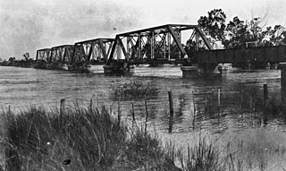
The Ross River is a river in North Queensland, Australia. The 49-kilometre (30 mi) long river flows through the city of Townsville and empties into the Coral Sea. It is the major waterway flowing through Townsville and the city's main source of drinking water.

Scottville is a rural town and locality in the Whitsunday Region, Queensland, Australia. In the 2016 census the locality of Scottville had a population of 259 people.

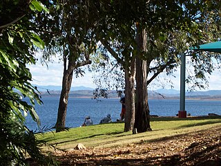
The Fairbairn Dam is an earth-filled embankment dam across the Nogoa River, located southwest of Emerald in Central Queensland, Australia. Constructed in 1972 for the primary purpose of irrigation, the impoundment created by the dam serves as one of the major potable water supplies for the region and assists with some flood mitigation.

<span class="mw-page-title-main">Boyne River (Central Queensland)</span> River in Queensland, Australia

The Boyne River is a river in Central Queensland, Australia.

<span class="mw-page-title-main">Jardine River</span> River in Queensland, Australia

The Jardine River, formally known as Deception River, is the largest river of the Cape York Peninsula in Far North Queensland, Australia.

<span class="mw-page-title-main">Wenlock River</span> River in Queensland, Australia

The Wenlock River is a river located on the Cape York Peninsula in Far North Queensland, Australia.

<span class="mw-page-title-main">Nogoa River</span> River in Queensland, Australia

The Nogoa River is a river in Central Queensland, Australia.

<span class="mw-page-title-main">Bogie River Hills</span>

The Bogie River Hills is a subregion of the Brigalow Belt North in Queensland, Australia.

The Settlement Creek is a creek in the Northern Territory and the state of Queensland, Australia.

<span class="mw-page-title-main">Gregory River (Australia)</span> River in Queensland and Northern Territory, Australia

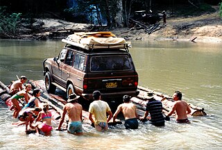
The Gregory River is a river in the Northern Territory and the state of Queensland, Australia. The river is the largest perennial river in arid and semi-arid Queensland, one of the few permanently flowing rivers in the northwest of Queensland.

The Holroyd River is a river located on the Cape York Peninsula in Far North Queensland, Australia.

The Barratta Creek is a creek in North Queensland, Australia.

<span class="mw-page-title-main">Mossman River</span> River in Far North Queensland, Australia

The Mossman River is a river in the Cape York Peninsula of Far North Queensland, Australia.

References

  1. 1 2 "BowenRiver (entry 4113)". Queensland Place Names. Queensland Government . Retrieved 19 July 2015.
  2. 1 2 "Map of Bowen River Qld". Bonzle Digital Atlas of Australia. Retrieved 19 July 2015.
  3. "Bowen River drainage basin". WetlandInfo. Queensland Government . Retrieved 19 July 2015.[ permanent dead link ]
  4. "Bowen River". NQ Dry Tropic. Retrieved 19 July 2015.
  5. Ghassemi, Fereidoun; Ian White (2007). Inter-Basin Water Transfer: Case Studies from Australia, United States, Canada, China and India. Cambridge University Press. p. 189. ISBN   978-1139463041 . Retrieved 19 July 2015.
  6. Jack, Felicity (2008). Putting Queensland on the Map: The Life of Robert Logan Jack, Geologist & Explorer. UNSW Press. p. 126. ISBN   978-1921410260 . Retrieved 19 July 2015.
  7. "Daintree, Richard (1832–1878)". Australian Dictionary of Biography, National Centre of Biography. Australian National University. Retrieved 19 July 2015.
  8. "Bowen River Hotel (entry 600042)". Queensland Heritage Register . Queensland Heritage Council. Retrieved 1 August 2014.
  9. "Bowen River Pump Station". Thiess. Archived from the original on 21 July 2015. Retrieved 19 July 2015.

Commons-logo.svg Media related to Bowen River (Queensland) at Wikimedia Commons