
Carnarvon National Park is located in the Southern Brigalow Belt bioregion in the Maranoa Region in Central Queensland, Australia. The park is 593 km northwest of Brisbane. It began life as a 26,304-hectare (65,000-acre) reserve gazetted in 1932 to protect Carnarvon Gorge for its outstanding scenic values, its Indigenous and non-Indigenous cultural heritage, and its geological significance.

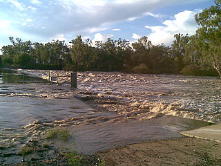
The Darling River is the third-longest river in Australia, measuring 1,472 kilometres (915 mi) from its source in northern New South Wales to its confluence with the Murray River at Wentworth. Including its longest contiguous tributaries it is 2,844 km (1,767 mi) long, making it the longest river system in Australia. The Darling River is the outback's most famous waterway.
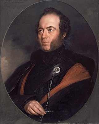
Sir Thomas Livingstone Mitchell, often called Major Mitchell, was a Scottish surveyor and explorer of Southeastern Australia. He was born in Scotland and served in the British Army during the Peninsular War. In 1827 he took up an appointment as Assistant Surveyor General of New South Wales. The following year he became Surveyor General and remained in this position until his death. Mitchell was knighted in 1839 for his contribution to the surveying of Australia.

The Condamine River, part of the Balonne catchment that is part of the Murray-Darling Basin, drains the northern portion of the Darling Downs, an area of sub-coastal southern Queensland, Australia. The river is approximately 500 kilometres (310 mi) long and rises on Mount Superbus, South East Queensland's highest peak, on the western slopes of the Great Dividing Range, approximately 100 kilometres (62 mi) from the east coast of Queensland, and then flows north west across the Darling Downs, then west. The Condamine River is a tributary of the Darling River.
The Culgoa River is a river that is part of the Darling catchment within the Murray–Darling basin and is located in South West Queensland.

The Balonne River, part of the Murray-Darling Basin system, is a short yet significant part of the inland river group of South West Queensland, Australia.

Barwon River, a perennial river that is part of the Murray–Darling basin, is located in the north-west slopes and Orana regions of New South Wales, Australia.

The Warrego River is an intermittent river that is part of the Darling catchment within the Murray–Darling basin, which is located in South West Queensland and in the Orana region of New South Wales, Australia. The Warrego River is the northernmost tributary of the Darling River.
The Dawson River is a river in Central Queensland, Australia.

The Bungil Creek, part of the Balonne catchment within the Murray-Darling basin, is a perennial stream in South West Queensland, Australia.

The Maranoa is the name given to an area of southern Queensland, about 500 kilometres (kms) west of Brisbane. Some refer to the Maranoa as the Western Downs. The Maranoa is an eastern part of the larger, mostly arid South West region of Queensland. To the east is the agricultural region of the Darling Downs and in the west is the dry Channel Country.

The Moonie River (Mooni River) is a river in Shire of Balonne, Queensland and Walgett Shire, New South Wales, both in Australia. It is a perennial river of the Barwon catchment within the Murray–Darling basin.
The Merivale River, part of the Darling catchment of the Murray-Darling basin, is a river in South West Queensland, Australia.
The Nogoa River is a river in Central Queensland, Australia.

The Brigalow Belt is a wide band of acacia-wooded grassland that runs between tropical rainforest of the coast and the semi-arid interior of Queensland and northern New South Wales, Australia. The Interim Biogeographic Regionalisation for Australia (IBRA) divides the Brigalow Belt into two IBRA regions, or bioregions, Brigalow Belt North (BBN) and Brigalow Belt South (BBS). The North and South Brigalow Belt are two of the 85 bioregions across Australia and the 15 bioregions in Queensland. Together they form most of the Brigalow tropical savanna ecoregion.

The Carnarvon Range is a mountain range in Central Queensland, Australia. It is a plateau section of the Great Dividing Range. The Carnarvon Range is 160 km in length.
The Bokhara River, a watercourse that is part of the Barwon catchment within the Murray–Darling basin, is located in the South Downs region of Queensland, flowing downstream into the north–western slopes of New South Wales, Australia. It flows through the lower Balonne floodplain.

The Nive River is a river that is part of the Darling catchment within the Murray–Darling basin, is located in the south west region of Queensland, Australia.
The Narran Wetlands, also known as the Narran Lakes, contained within the Narran Lake Nature Reserve, comprise a series of protected ephemeral lakes and swamps fed by the Narran River in the north-west of New South Wales, Australia. The 26,480-hectare (65,400-acre) reserve is located approximately 50 kilometres (31 mi) east of Brewarrina.

South West Queensland is a remote region in the Australian state of Queensland which covers 319,808 km2 (123,479 sq mi). The region lies to the south of Central West Queensland and west of the Darling Downs and includes the Maranoa district and parts of the Channel Country. The area is noted for its cattle grazing, cotton farming, opal mining and oil and gas deposits.

