Ducie River

Last updated

Ducie
Australia Queensland relief location map.jpg
Red pog.svg
Location of Ducie River mouth in Queensland
EtymologyIn honour of the Earl of Ducie [1]
Location
Country Australia
State Queensland
Region Far North Queensland
Physical characteristics
SourceRichardson Range, Great Dividing Range
Source confluencePalm Creek and South Palm Creek
  locationwest of Bramwell Roadhouse
  coordinates 12°06′47″S142°25′08″E / 12.11306°S 142.41889°E / -12.11306; 142.41889
  elevation30 m (98 ft)
Mouth Gulf of Carpentaria
  location
Port Musgrave
  coordinates
12°03′S142°01′E / 12.050°S 142.017°E / -12.050; 142.017
  elevation
0 m (0 ft)
Length69 km (43 mi)
Basin size6,746 km2 (2,605 sq mi)
Basin features
Tributaries 
  rightDulhunty River
[2]

The Ducie River is a river located on the Cape York Peninsula in Far North Queensland, Australia.

Contents

Formed by the confluence of the Palm Creek and South Palm Creek, the headwaters of the Ducie River drain the Richardson Range, part of the Great Dividing Range. The river flows generally west through stringybark woodlands, tropical savanna plains and wetlands. It enters the Gulf of Carpentaria on the western side of the Cape York Peninsula at Port Musgrave just north of Mapoon. The river descends 31 metres (102 ft) over its 69-kilometre (43 mi) course. [2]

The catchment covers 6,746 square kilometres (2,605 sq mi); [3] there are no major towns or water storage facilities in the watershed.

Much of the river is bordered by gallery rainforest. In its lower reaches it supports an extensive tidal mangrove forest with stands of Nipa Palms. [4]

History

Luthigh (also known as Lotiga, Tepiti and Uradhi, see also Uradhi related languages) is an Australian Aboriginal language spoken by the Luthigh people. The traditional language area for Luthigh includes landscape within the local government boundaries of the Cook Shire: Eastern Cape York, Ducie River, Northern Peninsula, New Mapoon, Injinoo, and Cowal Creek. [5]

Teppathiggi (also known Tepithiki and Teyepathiggi) is an Australian Aboriginal language of the Western Cape York, Middle Dulcie River, Lower Batavia River, Ducie River, and Mapoon. The language region includes areas within the local government boundaries of Cook Shire Council. [6]

Uradhi (also known as Anggamudi, Ankamuti, Atampaya, Bawtjathi, and Lotiga) is an Australian Aboriginal language of the Western Cape York Peninsula. The traditional language region includes north of Mapoon and Duyfken Point and east of the coast strip to the north of Port Musgrave (Angkamuthi country) incorporating the mouth of the Ducie River, the lower reaches of the Dulhunty River and the upper reaches of the Skardon River in the north. Following the displacement of Indigenous people by British settlement, it was also spoken in the Northern Peninsula Area Region, including New Mapoon, Injinoo and Cowal Creek communities. [7]

The river was named in 1886 by Francis Lascelles Jardine, a pastoralist, reportedly after the Earl of Ducie, presumably a relative of the Jardine family. [1]

See also

Related Research Articles

<span class="mw-page-title-main">Cape York Peninsula</span> Peninsula in Far North Queensland, Australia

Cape York Peninsula is a peninsula located in Far North Queensland, Australia. It is the largest unspoiled wilderness in northern Australia. The land is mostly flat and about half of the area is used for grazing cattle. The relatively undisturbed eucalyptus-wooded savannahs, tropical rainforests and other types of habitat are now recognised and preserved for their global environmental significance. Although much of the peninsula remains pristine, with a diverse repertoire of endemic flora and fauna, some of its wildlife may be threatened by industry and overgrazing as well as introduced species and weeds.

<span class="mw-page-title-main">Pennefather River</span> River in Queensland, Australia

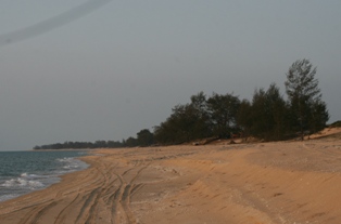
The Pennefather River is a river located on the western Cape York Peninsula in Far North Queensland, Australia.

<span class="mw-page-title-main">North Queensland</span> Region in Queensland, Australia

North Queensland or the Northern Region is the northern part of the Australian state of Queensland that lies just south of Far North Queensland. Queensland is a massive state, larger than many countries, and its tropical northern part has been historically remote and undeveloped, resulting in a distinctive regional character and identity.

<span class="mw-page-title-main">Bamaga</span> Town in Queensland, Australia

Bamaga is a small town and locality about 40 kilometres (25 mi) from the northern tip of Cape York in the north of Queensland, Australia. It is within the Northern Peninsula Area Region. It is one of the northernmost settlements in continental Australia and is the administrative centre for the Northern Peninsula Area Regional Council.

<span class="mw-page-title-main">Pormpuraaw, Queensland</span> Town in Queensland, Australia

Pormpuraaw is a coastal town and a locality in the Aboriginal Shire of Pormpuraaw, Queensland, Australia. Pormpuraaw is an Aboriginal community situated on the west coast of Cape York Peninsula approximately halfway between Karumba and Weipa on the Edward River. It is 650 kilometres (400 mi) by road from Cairns. Pormpuraaw currently has a 4-man police station.

<span class="mw-page-title-main">Injinoo, Queensland</span> Town in Queensland, Australia

Injinoo is a coastal town in the Northern Peninsula Area Region and a locality split between Northern Peninsula Area Region and the Shire of Torres in Far North Queensland, Australia. It is on the north-western coast of Cape York Peninsula. In the 2016 census, Injinoo had a population of 561 people.

<span class="mw-page-title-main">Mapoon, Queensland</span> Town in Queensland, Australia

Mapoon is a coastal town in the Aboriginal Shire of Mapoon and a locality split between the Aboriginal Shire of Mapoon and the Shire of Cook in Queensland, Australia. In the 2016 census, Mapoon had a population of 317 people.

<span class="mw-page-title-main">New Mapoon, Queensland</span> Town in Queensland, Australia

New Mapoon is a town in the Northern Peninsula Area Region and coastal locality split between the Northern Peninsula Region and Shire of Torres, Queensland, Australia. In the 2016 census, New Mapoon had a population of 383 people.

Urradhi is a Paman language of the Cape York Peninsula of Queensland, Australia, and is apparently extinct. It was spoken by the Urradhi people. Urradhi proper is the south-western dialect of the language. The name is composed of urra "this" and the proprietive dhi "having". The south-eastern dialect of the same language, Wudhadhi, is made of the same elements, wudha being "this". These are part of a group of closely related and highly mutually intelligible dialects, these being Angkamuthi to the north of Urradhi, Atampaya inland from these, Utudhanamu inland north from Atampaya, Yantaykenu further north, being the language of the Bamaga area, Yadhaykenu on the east coast north of Wudhadhi, and Yaraytyana further north again. This group has no common language name, though Urradhi is commonly used as a cover name. It is unknown when it became extinct.

Anguthimri is an extinct Paman language formerly spoken on the Cape York Peninsula of Queensland, Australia, by the Anguthimri people who lived in the area from the mouth of the Mission River north to Pennefather River and west to Duyfken Point. It is unknown when it became extinct.

<span class="mw-page-title-main">Shire of Cook</span> Local government area in Queensland, Australia

The Shire of Cook is a local government area in Far North Queensland, Australia. The Shire covers most of the eastern and central parts of Cape York Peninsula, the most northerly section of the Australian mainland.

<span class="mw-page-title-main">Northern Peninsula Area Region</span> Local government area in Queensland, Australia

The Northern Peninsula Area Region is a local government area in Far North Queensland, Australia, covering areas on the northwestern coast of Cape York Peninsula. It was created in March 2008 out of three Aboriginal Shires and two autonomous Island Councils during a period of statewide local government reform. In June 2018, the area had a population of 3,069.

<span class="mw-page-title-main">Bloomfield River</span> River in Far North Queensland, Australia

The Bloomfield River is a river in the Wet Tropics of Far North Queensland, Australia, noted for its Bloomfield River cod fish species, found only in the river.

<span class="mw-page-title-main">Port Musgrave</span> Estuarine bay in Far North Queensland

Port Musgrave is a shallow, almost enclosed, estuarine bay located on the western coast of the Cape York Peninsula in Far North Queensland, Australia.

<span class="mw-page-title-main">Wujal Wujal Aboriginal Shire</span> Local government area in Queensland, Australia

The Wujal Wujal Aboriginal Shire is a local government area in Far North Queensland, Australia. It is managed as a Deed of Grant in Trust under the Local Government Act 2004.

Mbiywom (Mbeiwum) is an extinct Australian Aboriginal language formerly spoken by the Mbiywom people around the areas of Cape York and Cook Shire in Far North Queensland.

<span class="mw-page-title-main">Umagico, Queensland</span> Suburb of Northern Peninsula Area Region, Queensland, Australia

Umagico is a town and coastal locality in the Northern Peninsula Area Region, Queensland, Australia. In the 2016 census, Umagico had a population of 427 people.

The Ngathokudi (Ngadhugudi) were an indigenous Australian people of the state of Queensland. Their language was possibly a dialect of Uradhi.

The Nggamadi were an indigenous Australian people of the Cape York Peninsula of northern Queensland.

Duyfken Point is a point in the locality of Mission River, Shire of Cook, Queensland, Australia.

References

  1. 1 2 "Ducie River (entry 10656)". Queensland Place Names. Queensland Government . Retrieved 19 June 2015.
  2. 1 2 "Map of Ducie River, QLD". Bonzle Digital Atlas of Australia. Retrieved 24 November 2015.
  3. "Water resources - Overview - Queensland - Basin & Surface Water Management Area: Ducie River". Australian Natural Resources Atlas. Department of the Environment, Water, Heritage and the Arts. Archived from the original on 4 October 2009. Retrieved 7 December 2009.
  4. "Ducie River". Wild Rivers. Archived from the original on 21 November 2008.
  5. "Luthigh". State Library of Queensland. Retrieved 30 January 2020.
  6. CC BY icon-80x15.png This Wikipedia article incorporates CC-BY-4.0 licensed text from: "Teppathiggi". Queensland’s Aboriginal and Torres Strait Islander Languages map. State Library of Queensland . Retrieved 5 February 2020.
  7. CC BY icon-80x15.png This Wikipedia article incorporates CC-BY-4.0 licensed text from: "Uradhi". Queensland Aboriginal and Torres Strait Islander languages map. State Library of Queensland . Retrieved 5 February 2020.