| Breakfast | |
|---|---|
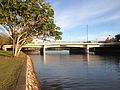
 Breakfast Creek | |
 Location of the Breakfast Creek mouth in Queensland | |
| Etymology | Derived from breakfast [1] |
| Native name | Yawagara / Enoggera (Aboriginal) |
| Location | |
| Country | Australia |
| State | Queensland |
| Region | South East Queensland |
| City | Brisbane |
| Physical characteristics | |
| Source | D'Aguilar Range |
| • location | D'Aguilar National Park |
| Source confluence | Enoggera Creek |
| • location | Herston |
| • coordinates | 27°26′41″S153°1′59″E / 27.44472°S 153.03306°E |
| • elevation | 2 m (6 ft 7 in) |
| Mouth | confluence with the Brisbane River |
• location | Albion, Newstead |
• coordinates | 27°26′31″S153°2′51″E / 27.44194°S 153.04750°E |
• elevation | 1 m (3 ft 3 in) |
| Length | 2 km (1.2 mi) |
| Basin features | |
| River system | Brisbane River |
The Breakfast Creek (Aboriginal: Yawagara [2] ) is a small urban stream that is a tributary of the Brisbane River, located in suburban Brisbane in the South East region of Queensland, Australia.