Pine River (Queensland)

Last updated

Pine River
Dohls Rocks Road and Pine River at Griffin, Queensland.jpg
Dohles Rocks Road at Griffin, 2016
Australia Queensland relief location map.jpg
Red pog.svg
Location of the Pine River mouth in Queensland
Location
Country Australia
State Queensland
Region South East Queensland
Physical characteristics
Source D'Aguilar Range
Source confluence North and South Pine Rivers
  location Lawnton
  coordinates 27°17′15″S153°00′57″E / 27.28750°S 153.01583°E / -27.28750; 153.01583
  elevation11 m (36 ft)
Mouth Bramble Bay, Moreton Bay
  location
north of Brighton
  coordinates
27°16′39″S153°04′35″E / 27.27750°S 153.07639°E / -27.27750; 153.07639
  elevation
0 m (0 ft)
Length7 km (4.3 mi)
Basin features
Tributaries 
  rightBald Hills Creek
[1]

The Pine River is a small river in South East Queensland, Australia.

Contents

The river is formed by the confluence of the North Pine and the South Pine rivers at Lawnton, continuing into Bramble Bay. The Brisway map reference is 440 D10.

Location and features

The Pine River carries the city border between the City of Moreton Bay and City of Brisbane along its middle (continuing up the South Pine River). The northern shoreline follows Pine Rivers suburbs of Murrumba Downs and Griffin, while the southern shoreline follows Brisbane suburbs of Bald Hills and Brighton. The river descends 11 metres (36 ft) over its 7-kilometre (4.3 mi) course. [1] The Bald Hills Creek feeds into the Pine River which create the Bald Hills Creek and Tinchi Tamba Wetlands Reserve, a large environmental park covering more than 380 hectares (940 acres). The Pine River and Hays Inlet wetland is significant because of its value to wildlife, especially migratory waders. [2] The Pine River is classified as being "extensively modified". [3]

The Pine Rivers Shire draws its name from the Pine, the North Pine and the South Pine rivers.

Flora species

Osprey House boardwalk, 2016 Osprey House boardwalk Griffin, Queensland.jpg
Osprey House boardwalk, 2016

The predominant land uses in the catchment area are native bush, grazing, rural residential and urban. [4]

Human uses

Water supply: North Pine Dam [5] North Pine Dam (Lake Samsonvale) is located on the North Pine River. The storage capacity for water supply is 215,000 megalitres (7,600×10^6 cu ft).

Recreational fishing: Pine River is a popular waterway for recreational fishing. Total estimated recreational catch for Pine River in 1997 was 1,509,755 fish (2.71% of Qld total) from an estimated 141,092 fishing trips (1.31% of Qld total). Estimated catch by top five species were: whiting 351,799, bream 230,598, winter whiting 203,028, diver whiting 190,131, snapper (squire) 127,298. (Data for 1999)

A maximum of ten commercial boats fished Pine River in 1999, for a total catch of 21.9 tonnes (21.6 long tons; 24.1 short tons). Pine River is also used for other water based recreation including water skiing and the use of personal water craft.

See also

Related Research Articles

<span class="mw-page-title-main">Moreton Bay</span> Inlet in southern Queensland, Australia

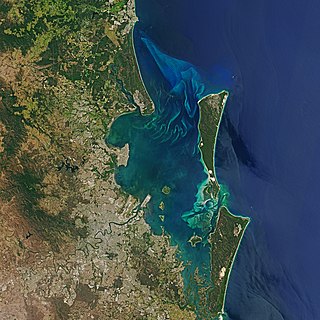
Moreton Bay is a bay located on the eastern coast of Australia 14 kilometres (8.7 mi) from central Brisbane, Queensland. It is one of Queensland's most important coastal resources. The waters of Moreton Bay are a popular destination for recreational anglers and are used by commercial operators who provide seafood to market.

<span class="mw-page-title-main">Mitchell River (Queensland)</span> River in Queensland, Australia

The Mitchell River is a river in Far North Queensland, Australia. The river rises on the Atherton Tableland about 50 kilometres (31 mi) northwest of Cairns and flows about 750 kilometres (470 mi) northwest across Cape York Peninsula from Mareeba to the Gulf of Carpentaria.

<span class="mw-page-title-main">Bulimba Creek</span> River in Queensland, Australia

Bulimba Creek, originally known as Doboy Creek or Doughboy Creek, is a perennial stream that is a tributary of the Brisbane River, located in suburban Brisbane in the South East region of Queensland, Australia.

<span class="mw-page-title-main">Hays Inlet</span>

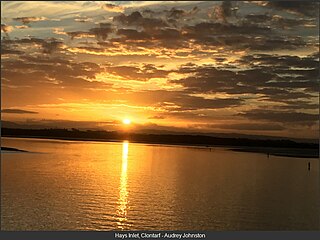
Hays Inlet is a saltwater inlet off Bramble Bay in the City of Moreton Bay, Queensland, Australia. The Brisway map reference is 420 L19. A mangrove forest is found in the inlet.

<span class="mw-page-title-main">South Pine River</span> River in Queensland, Australia

The South Pine River is a minor river in South East Queensland, Australia. It rises on the D'Aguilar Range and passes through the Samford Valley in the City of Moreton Bay local government area.

<span class="mw-page-title-main">North Pine Dam</span> Dam in South East Queensland

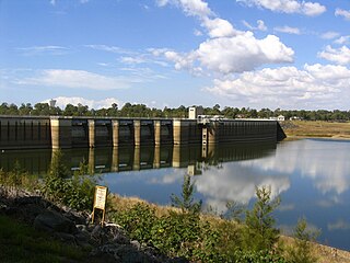
The North Pine Dam is a mass concrete gravity dam with earth-fill embankments on abutments with a gated spillway across the North Pine River that is located in the South East region of Queensland, Australia. The main purpose of the dam is for supply of potable water for the Moreton Bay region and Brisbane's northern suburbs. The impounded reservoir is called Lake Samsonvale.

<span class="mw-page-title-main">Bramble Bay</span> River in Queensland, Australia

Bramble Bay is an embayment of Moreton Bay in South East Queensland, Australia. The Brisway map reference is 12 H5, or see page 91 G19 in Refidex.

<span class="mw-page-title-main">North Pine River</span> River in Queensland, Australia

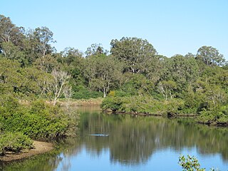
The North Pine River is a minor river in South East Queensland, Australia.

<span class="mw-page-title-main">Trumpeter whiting</span> Species of fish

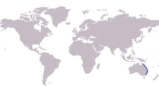
The trumpeter whiting, also known as the winter whiting or diver whiting, is a common species of coastal marine fish of the smelt-whiting family, Sillaginidae. The trumpeter whiting is endemic to Australia, inhabiting the eastern seaboard from southern New South Wales to northern Queensland. The species is found in bays, estuaries, coastal lakes and mangrove creeks on silty and muddy substrates in waters ranging from 0 to 30 m deep, occasionally inhabiting sandy and seagrass beds.

<span class="mw-page-title-main">Joyner, Queensland</span> Suburb of Moreton Bay, Queensland, Australia

Joyner is a suburb in the City of Moreton Bay, Queensland, Australia. It is part of the Brisbane metropolitan area. In the 2016 census, Joyner had a population of 2,833 people.

The Sideling Creek Dam is an earth-fill embankment dam with an un-gated spillway across the Sideling Creek in Kurwongbah, City of Moreton Bay, Queensland, Australia. The main purposes of the dam are for potable water supply of the City of Moreton Bay and for recreation. The impounded reservoir is called Lake Kurwongbah.

<span class="mw-page-title-main">Six Mile Creek Dam</span> Dam in South East Queensland

The Six Mile Creek Dam is a rock and earth-fill embankment dam with an un-gated spillway across the Six Mile Creek that is located in the South East region of Queensland, Australia. The main purposes of the dam are for potable water supply of the Sunshine Coast region and for recreation. The impounded reservoir is called Lake Macdonald, named in memory of former Noosa Shire Council Chairman Ian MacDonald.

<span class="mw-page-title-main">Tingalpa Creek</span> River in Queensland, Australia

Tingalpa Creek is a creek in South East Queensland. It flows along Brisbane's south east boundary with Redland City Council. On early maps the creek was called both Tunim Creek and Tangulba Creek.

<span class="mw-page-title-main">Caboolture River</span> River in Queensland, Australia

The Caboolture River is a small river in South East Queensland, Australia.

<span class="mw-page-title-main">Pimpama River</span> River in Queensland, Australia

The Pimpama River is a perennial river in the South East region of Queensland, Australia. Its catchment lies within the Gold Coast local government area and covers an area of 171 square kilometres (66 sq mi).

<span class="mw-page-title-main">Maroochy River</span> River in Queensland, Australia

The Maroochy River is a river in South East Queensland, Australia. The river rises from the eastern slopes of the Blackall Range and flows east through Eumundi before entering the sea at Cotton Tree, Maroochydore. Other populated centres in the catchment include Nambour, Eudlo, Yandina and Coolum.

Burpengary Creek is a tidal creek in the City of Moreton Bay, Queensland, Australia. It has a total catchment area of 7,960 hectares. It is about 40 kilometres north of Brisbane,

<span class="mw-page-title-main">Australian mangroves</span> Distribution of Australian mangroves

Australia has Areas where mangroves occur including the intertidal zone of tropical, subtropical and protected temperate coastal rivers, estuaries, bays and marine shorelines. Less than 1% of Australia's total forest area is mangrove forest.

The Alice River is a river located on the Cape York Peninsula of Far North Queensland, Australia.

<span class="mw-page-title-main">Geography of Brisbane</span> Geography of the city of Brisbane in Queensland, Australia

The geography of Brisbane is characterised by its coastal location in the south eastern corner of the Queensland state of Australia. It is located halfway up the Australian east coast with longitudinal and latitudinal coordinates of 27.5° south and 153° east. The city resides within the Moreton Bay Floodplain, stretching from Caboolture to the north, Beenleigh to the south and as far as Ipswich to the west whilst being bordered by the Pacific Ocean to the east.

References

  1. 1 2 "Map of Pine River, QLD". Bonzle Digital Atlas of Australia. Retrieved 7 October 2015.
  2. "Australian wetlands database". Australian Government. 2008. Retrieved 15 January 2008.
  3. "Ozcoasts database". ozcoasts.org.au. 2008. Retrieved 15 January 2008.
  4. "Pine Rivers Catchment and Estuary (2008)". emph.org. Archived from the original on 3 December 2007. Retrieved 15 January 2008.
  5. "SEQWater's Dams (2002)". seqwater.com.au. Archived from the original on 9 January 2008. Retrieved 15 January 2008.