For much of its length, Kedron Brook is lined with parks and sporting facilities such as bikeways and football fields. Kedron Brook has been channelised where it passes suburbs such as Lutwyche and Wooloowin. Tidal influence reaches as far as Toombul.[4]
History
Kedron Brook in flood at Alderley, 2022
Kedron Brook was named by the German missionary group which established German Station (now Nundah) in March 1838. It is named after Kidron Valley near Jerusalem.[1] In the 1880s, small amounts of coal were found along the banks of the creek.[5]
The original course of Kedron Brook has been significantly altered in the vicinity of Brisbane Airport, where it has been redirected to a canal named the Schulz Canal.[6] This was done to allow expansion of the airport in recent decades.[7] The canal empties into Moreton Bay adjacent to the small bayside village of Nudgee Beach. At the lower end of the catchment, Boondall Wetlands is an internationally recognised habitat (Ramsar site) for migratory wader birds and other animals in Moreton Bay.[3]
Kedron Brook flooded during the 2022 Brisbane floods.[8] Flood damage eradicated a large section of a popular bike track.[9] Repairs to the bikeway took months to complete and cost millions of dollars.[9]
Gallery
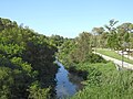
Kedron Brook stream, looking downstream from Gympie Road, Kedron (2021)
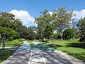
Bicycle and pedestrian paths, Kalinga Park, Kalinga (2021)
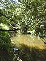
Kedron Brook looking upstream, Kalinga Park, Kalinga (2021)
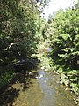
Kedron Brook looking downstream, Kalinga Park, Kalinga (2021)
This page is based on this Wikipedia article Text is available under the CC BY-SA 4.0 license; additional terms may apply. Images, videos and audio are available under their respective licenses.