The Albert River is a river in the Gulf Country of Queensland, Australia. It passes by the town of Burketown and drains into the Gulf of Carpentaria. The waters near the mouth of the river are frequented by dugongs. [1]
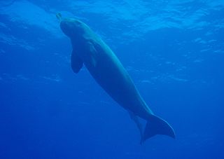
The dugong is a medium-sized marine mammal. It is one of four living species of the order Sirenia, which also includes three species of manatees. It is the only living representative of the once-diverse family Dugongidae; its closest modern relative, Steller's sea cow, was hunted to extinction in the 18th century.

The Gulf of Thailand, also known as the Gulf of Siam, is a shallow inlet in the southwestern South China Sea, bounded between the southwestern shores of the Indochinese Peninsula and the northern half of the Malay Peninsula. It is around 800 km (500 mi) in length and up to 560 km (350 mi) in width, and has a surface area of 320,000 km2 (120,000 sq mi). The gulf is surrounded on the north, west and southwest by the coastlines of Thailand, on the northeast by Cambodia and the Mekong Delta region of Vietnam, and opens to the South China Sea in the southeast.

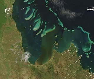
The Gulf of Carpentaria is a large, shallow sea enclosed on three sides by northern Australia and bounded on the north by the eastern Arafura Sea. The northern boundary is generally defined as a line from Slade Point, Queensland in the northeast, to Cape Arnhem on the Gove Peninsula, Northern Territory in the west.

The Norman River is a river in the Gulf Country, Queensland, Australia. The river originates in the Gregory Range 200 km southeast of Croydon and flows 420 km northwest to the Gulf of Carpentaria. It is joined by three major tributaries, the Carron, Clara and Yappar Rivers. The river flows through Normanton before entering the Gulf of Carpentaria through the major fishing port of Karumba. The mouth of the river lies in the Gulf Plains Important Bird Area.
Princess Charlotte Bay is a large bay on the east coast of Far North Queensland at the base of Cape York Peninsula, 350 km north northwest of Cairns. Princess Charlotte Bay is a part of the Great Barrier Reef Marine Park and it is a habitat for the dugong.

The Leichhardt Falls is a plunge waterfall on the Leichhardt River in the Gulf Country region of North West Queensland, Australia.

Burketown is an isolated outback town and coastal locality in the Shire of Burke, Queensland, Australia. In the 2016 census the locality of Burketown had a population of 238 people.
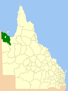
The Shire of Burke is a local government area in North West Queensland, Australia. The shire lies on the south coast of the Gulf of Carpentaria and abuts the border with the Northern Territory. It covers an area of 39,864 square kilometres (15,391.6 sq mi), and has existed as a local government entity since 1885. The major town and administrative centre of the shire is Burketown. The shire and town are named in honour of ill-fated explorer Robert O'Hara Burke. The Gangalidda name for Burketown is Mungibi meaning ‘little Island’ for the fact that flooding in the wet season often isolates the town.

The Shire of Mornington is a local government area in northwestern Queensland, Australia. The shire covers Mornington Island as well as neighbouring islands in the Wellesley Islands group in the Gulf of Carpentaria. Ninety-three percent of the employees of the Shire Council are indigenous local residents.

The Edward River is a river located in Far North Queensland, Australia.

The Gulf Country is the region of woodland and savanna grassland surrounding the Gulf of Carpentaria in north western Queensland and eastern Northern Territory on the north coast of Australia. The region is also called the Gulf Savannah. It contains large reserves of zinc, lead and silver. The Gulf Country is crossed by the Savannah Way highway.

Gregory is a rural town and locality in the Shire of Burke, Queensland, Australia. In the 2016 census, Gregory had a population of 72 people.
The Susan River is a river located in the Wide Bay–Burnett region of Queensland, Australia.
Umpila is an Aboriginal Australian language, or dialect cluster, of the Cape York Peninsula. It is spoken by about 100 Aboriginals, many of them elderly.

Duchess is a rural town and locality in the Shire of Cloncurry, Queensland, Australia. In the 2016 census, Duchess had a population of 23 people.
The Yappar River is a river located in the Gulf Country region of Far North Queensland, Australia.
The Clara River is a river located in the Gulf Country of northwest Queensland, Australia.

Sweers Island is an island in the South Wellesley Islands in the Gulf of Carpentaria, Queensland, Australia. It is within the Shire of Mornington.
The Settlement Creek is a creek located in the Northern Territory and the state of Queensland, Australia.
The Umpila are an Indigenous Australian people of the eastern Cape York Peninsula in northern Queensland. The majority of the remnant of the Umpila now live in Lockhart.
Rivers of Queensland | |||||||||||||||
|---|---|---|---|---|---|---|---|---|---|---|---|---|---|---|---|
| |||||||||||||||
| |||||||||||||||
| |||||||||||||||
| |||||||||||||||
| |||||||||||||||
Coordinates: 17°34′29″S139°45′20″E / 17.5747°S 139.7555°E
| | This Queensland river or creek related article is a stub. You can help Wikipedia by expanding it. |