Logan River

Last updated

Logan
Logan River 1.jpg
The Logan River at Jimboomba, 2011
Australia Queensland relief location map.jpg
Red pog.svg
Location of the Logan River mouth in Queensland
EtymologyCaptain Patrick Logan
Native nameDugulumba (Minjungbal)
Location
Country Australia
State Queensland
Region South East Queensland
Local government areas Scenic Rim Region, City of Logan, City of Gold Coast
Cities Beaudesert, Logan City
Physical characteristics
Source Scenic Rim
  locationbelow Mount Ernest
  coordinates 28°19′40″S152°42′55″E / 28.32778°S 152.71528°E / -28.32778; 152.71528 (Logan River (source))
  elevation380 m (1,250 ft)
Mouth Moreton Bay
  location
east of Alberton
  coordinates
27°41′40″S153°20′43″E / 27.69444°S 153.34528°E / -27.69444; 153.34528 (Logan River (mouth))
  elevation
0 m (0 ft)
Length184 km (114 mi)
Basin size3,076 km2 (1,188 sq mi)
Basin features
Tributaries 
  leftMount Barney Creek, Burnett Creek, Tamrookum Creek, Knapps Creek (Queensland), Sandy Creek (Queensland), Allan Creek, Teviot Brook, Flagstone Creek (Queensland)
  rightRunning Creek, Oaky Creek (Queensland), Christmas Creek (Queensland), Albert River
National park Mount Barney National Park
[1] [2] [3]

The Logan River (Yugambeh: Dugulumba [3] ) is a perennial river in the Scenic Rim, Logan and Gold Coast local government areas of the South East region of Queensland, Australia. The 184-kilometre (114 mi)-long river is one of the dominant waterways in South East Queensland that drains the southern ranges of the Scenic Rim and empties into Moreton Bay after navigating the City of Logan, a major suburban centre located south of Brisbane. The catchment is dominated by urban and agricultural land use. Near the river mouth are mangrove forests and a number of aquaculture farms. [4]

Contents

Course and features

Woodhill, 2016 Logan River at Woodhill, Queensland.jpg
Woodhill, 2016
Logan Bridge below Tamrookum, 1903 StateLibQld 1 232902 Riders on the Logan Bridge below Tamrookum, 1903.jpg
Logan Bridge below Tamrookum, 1903
Bridge construction on the Logan River, 1930 StateLibQld 1 132332 Bridge construction on the Logan River, 1930.jpg
Bridge construction on the Logan River, 1930

The river rises below Mount Ernest on the southern slopes of the Scenic Rim, part of the Great Dividing Range and forms in the Mount Barney National Park, near the Queensland  New South Wales border, below Mount Lindesay. The river flows generally north by northeast, joined by eleven minor tributaries, before heading east and eventually emptying into Moreton Bay. Its principal tributaries are the Albert River which joins it just east of Beenleigh; Teviot Brook which begins at Mount Superbus and joins the Logan River at Cedar Pocket; and Burnett Creek which is subverted by the Maroon Dam west of Rathdowney. The river descends 380 metres (1,250 ft) over its 184-kilometre (114 mi) course. [1]

The Mount Lindesay Highway via the Maclean Bridge at North Maclean, 2014 Maclean Bridge North Maclean.JPG
The Mount Lindesay Highway via the Maclean Bridge at North Maclean, 2014
Logan River at Carbrook (left) and Alberton (right), 2014 Logan River at Carbrook (left) and Alberton (right), 2014.JPG
Logan River at Carbrook (left) and Alberton (right), 2014

In addition to the Scenic Rim, the Logan and its tributaries drain more than 3,000 square kilometres (1,200 sq mi) including the northern parts of the Border Ranges, the western slopes of the McPherson Range and the eastern slopes of the Main Range. The river's upper catchment is heavily influenced by the national parks of Tamborine, Mount Barney, Moogerah Peaks, Main Range and the Lamington Plateau, and numerous local government-owned reserves and conservation areas, [5] that comprise part of the Shield Volcano Group of the UNESCO World Heritage Site Gondwana Rainforests of Australia.

The river is crossed by the Mount Lindesay Highway near Rathdowney and at North Maclean via Maclean's Bridge. The river is also crossed by the Pacific Motorway and the Old Pacific Highway south of Loganholme. [1] The Beenleigh railway line crosses the Logan between Loganlea and Bethania. A second rail crossing is planned to accommodate a doubling of rail tracks between the Kuraby and Beenleigh in time for the 2032 Brisbane Olympics. [6] Tidal waters reach to just downstream of the Maclean's Bridge. [3]

Water harvesting

Maroon Dam subverts Burnnett Creek, and supplies water to the Beaudesert Shire. Maroon is managed by SunWater and covers approximately 106 square kilometres (41 sq mi). The Queensland Government has considered several projects to supply water to its Southern Regional Pipeline. The Bromelton off-stream storage facility is under construction on the Logan River, outside Beaudesert, as is the Cedar Grove Weir, near Jimboomba. In 2006 the Queensland Government decided against the construction of a Logan River dam at Tilley's Bridge in Rathdowney due to mounting public pressure and high road diversion costs. Instead, the Wyaralong Dam was proposed on Teviot Brook near Boonah which will inundate fifteen properties instead of the one hundred properties for the Tilley's Bridge site. The Tilley's Bridge dam, if it had been approved, would have inundated the area of land between Tilley's Bridge, just to the south of Rathdowney, and Bigriggan Camping Reserve ( 28°11′55″S152°46′48″E / 28.1986°S 152.7799°E / -28.1986; 152.7799 (Bigriggan) ), some 8 kilometres (5.0 mi) west, covering a significant section of the Boonah-Rathdowney Road.

History

The Yugambeh clan of the Jagera people are thought to have once roamed throughout the catchment. Traditional owners in the catchment made use of the abundant natural resources, various plants and animals were used as staple foods as the seasons changed and as new food sources became available. They called the river Dugulumba in their traditional Yugambeh dialect [3] of the Bandjalang language. Yugembah (also known as Yugumbir, Jugambel, Jugambeir, Jugumbir, Jukam, Jukamba) is one of the Australian Aboriginal languages in areas that include the Beenleigh, Beaudesert, Gold Coast, Logan, Scenic Rim, Albert River, Coolangatta, Coomera, Logan River, Pimpama, Tamborine and Tweed River Valley, within the local government boundaries of the City of Gold Coast, City of Logan, Scenic Rim Regional Council and the Tweed River Valley. [7]

Mununjali (also known as Mananjahli, Manaldjahli and Manandjali) is a dialect of the Yugambeh language. The Mununjali language area includes landscape within the local government boundaries of the Scenic Rim and Beaudesert Shire Councils. [8]

In August 1826 Captain Patrick Logan was the first European to discover the river. Logan initially named the river the Darling River, but to avoid confusion, Governor Ralph Darling ordered the name be changed to honour its discoverer. [9] A run at Bromelton was the first property along the river to be settled in 1842 by Hugh Henry Robertson. [10] By 1850 the property had transferred hands to Thomas Lodge Murray-Prior. Rosa Campbell Praed, one of Queensland's first novelists spent time at the property and wrote about station life in detail in a 1902 book titled My Australian Girlhood. [10]

Boat traffic was thriving along the river by the 1860s mostly because it was the best transport route in the area. Steam ships, cutters and hand-loaded punts were the most common vessels. [11]

For navigation purposes the river was surveyed in 1871 from its mouth upstream to McLean. [11] Wharfs were initially built at McLean, Beenleigh, Waterford and Logan Village with more built due to public demand. [11] Unofficial ferry crossings were conducted as early as 1862. [11] Long-term services were established at Alberton, Loganholme and Waterford. The rail bridge at Loganlea was operating in 1885 only to be demolished two years later during floods. A new bridge opened in 1888 and lasted until 1972 when another bridge was built. [11]

In 1905, a 12 ft 7 in (3.84 m) saltwater crocodile was found shot dead floating near the ferry by banks of the river. [12] The find was preceded by reports of sightings for several years which were met with scepticism because southern Queensland is well south of their natural distribution. [12]

A toll bridge on the river north of Beenleigh was opened and began collecting tolls in 1931, [13] as weekend traffic between Brisbane and the Gold Coast increased. [14]

The worst flooding in the lower reaches of the river in the 20th century occurred during the 1974 Brisbane flood. [15]

Water quality and conservation

Running Creek near Andrew Drynan Park at Running Creek, 2016

The quality of the water in the Logan River is very turbid. [4] The annual Healthy Waterways Report Card for the waterways and catchments of South East Queensland in 2007 rated the condition of the Logan River as very poor. [16] Much of the environmental degradation has been caused by land clearing, the Bromelton Industrial Estate, [17] nutrient run-off, and pumping wastewater directly from several wastewater treatment plants in and around the Logan River. [18] In 2009, the Healthy Waterways Ecosystem Health Monitoring Program rated the River's freshwater area at a "D"; its Estuarine area was given an "F". [19] Historically, cholera has been found in the Logan River from around 1977. [20] [21] [22] [23] Community projects in the Logan catchment area aim to improve the quality of the ecosystem. Competitions such as Carp-busters are aimed at reducing the number of carp and hence allowing native species of fish a better chance of survival.

See also

Related Research Articles

<span class="mw-page-title-main">Mount Lindesay Highway</span> Highway in Queensland

Mount Lindesay Highway is an Australian national highway located in Queensland. The highway runs southwest from Brisbane, where it leaves Ipswich Road in the suburb of Moorooka, to the Queensland – New South Wales border and is 116 kilometres (72 mi) in length. For most of its length it is roughly aligned with the Sydney–Brisbane rail corridor. At its southern end these transport routes take different passes over the Scenic Rim into the Northern Rivers region. It is designated National Route 13.

<span class="mw-page-title-main">Rathdowney, Queensland</span> Town in Queensland, Australia

Rathdowney is a rural town and locality in the Scenic Rim Region, Queensland, Australia. In the 2016 census, Rathdowney had a population of 308 people.

<span class="mw-page-title-main">Beaudesert, Queensland</span> Town in Queensland, Australia

Beaudesert is a rural town and locality in the Scenic Rim Region, Queensland, Australia. In the 2016 census, Beaudesert had a population of 6,395 people.

<span class="mw-page-title-main">Beenleigh, Queensland</span> Suburb of City of Logan, Queensland, Australia

Beenleigh is a town and suburb in the City of Logan, Queensland, Australia. In the 2016 census, the suburb of Beenleigh had a population of 8,252 people.

<span class="mw-page-title-main">Mount Lindesay (Queensland)</span> Suburb of Scenic Rim Region, Queensland, Australia

Mount Lindesay is a rural locality in the Scenic Rim Region, Queensland, Australia. It borders New South Wales. In the 2016 census, Mount Lindesay had a population of 3 people.

<span class="mw-page-title-main">Albert River (South East Queensland)</span> River in Queensland, Australia

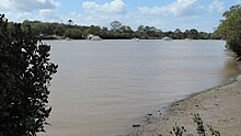
The Albert River is a perennial river in the South East region of Queensland, Australia. Its catchment lies within the Gold Coast and Scenic Rim Region local government areas and covers an area of 782 square kilometres (302 sq mi). The river provides potable water for the town of Beaudesert.

<span class="mw-page-title-main">Scenic Rim</span> Mountain ranges in Queensland and New South Wales

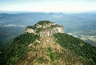
The Scenic Rim is a group of forested mountain ranges of the Great Dividing Range, located south of Brisbane agglomeration, straddling the border between south-eastern Queensland and north-eastern New South Wales, Australia. In 2021, the Scenic Rim was named as a Lonely Planet top destination for 2022.

<span class="mw-page-title-main">Beaudesert Shire</span> Local government area in Queensland, Australia

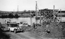
The Shire of Beaudesert was a local government area located in South East Queensland, Australia, stretching from the New South Wales border, along the Gold Coast hinterland to the urban fringes of the cities of Brisbane and Ipswich. The Shire covered an area of 2,854.3 square kilometres (1,102.1 sq mi), and existed from 1879 until its abolition on 15 March 2008, following which it was split between Logan City and the new Scenic Rim Region.

<span class="mw-page-title-main">Scenic Rim Region</span> Local government area in Queensland, Australia

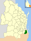
The Scenic Rim Region is a local government area in West Moreton region of South East Queensland, Australia. Established in 2008, it was preceded by several previous local government areas with histories extending back to the early 1900s and beyond. The main town of the region is Beaudesert.

<span class="mw-page-title-main">Bromelton, Queensland</span> Town in Queensland, Australia

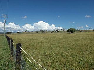
Bromelton is a rural locality in the Scenic Rim Region, Queensland, Australia. In the 2016 census, Bromelton had a population of 155 people.

<span class="mw-page-title-main">Barney View, Queensland</span> Suburb of Scenic Rim Region, Queensland, Australia

Barney View is a rural locality in the Scenic Rim Region, Queensland, Australia. In the 2016 census, Barney View had a population of 64 people.

<span class="mw-page-title-main">Tamborine, Queensland</span> Suburb of Logan City, Queensland, Australia

Tamborine is a rural town in the Scenic Rim Region and a locality split between the Scenic Rim Region and the City of Logan in Queensland, Australia. In the 2016 census, the locality of Tamborine had a population of 3,950 people.

<span class="mw-page-title-main">Palen Creek, Queensland</span> Suburb of Scenic Rim Region, Queensland, Australia

Palen Creek is a rural locality in the Scenic Rim Region, Queensland, Australia. It borders New South Wales. In the 2016 census, Palen Creek had a population of 280 people.

<span class="mw-page-title-main">Wyaralong, Queensland</span> Suburb of Scenic Rim Region, Queensland, Australia

Wyaralong is a rural locality in the Scenic Rim Region, Queensland, Australia. In the 2016 census, Wyaralong had a population of 20 people.

<span class="mw-page-title-main">Innisplain, Queensland</span> Suburb of Scenic Rim Region, Queensland, Australia

Innisplain is a rural locality in the Scenic Rim Region, Queensland, Australia. In the 2016 census, Innisplain had a population of 85 people.

<span class="mw-page-title-main">Running Creek, Queensland</span> Suburb of Scenic Rim Region, Queensland, Australia

Running Creek is a rural locality in the Scenic Rim Region, Queensland, Australia. In the 2016 census, Running Creek had a population of 147 people. It borders New South Wales.

<span class="mw-page-title-main">Gleneagle, Queensland</span> Suburb of Scenic Rim Region, Queensland, Australia

Gleneagle is a rural locality in the Scenic Rim Region, Queensland, Australia. In the 2016 census, Gleneagle had a population of 1,877 people.

Ipswich–Boonah–Rathdowney Road is a continuous 87.8 kilometres (54.6 mi) road route in the Ipswich and Scenic Rim regions of Queensland, Australia. It has two official names, Ipswich–Boonah Road and Boonah–Rathdowney Road. The entire route is signed as State Route 93, and much of it is also part of Tourist Drive 16.

Beaudesert–Boonah–Fassifern Road is a non-continuous 49.9 kilometres (31.0 mi) road route in the Scenic Rim region of Queensland, Australia. It has two official names, Beaudesert–Boonah Road and Boonah–Fassifern Road. The route is signed as State Route 90. These roads are joined by a 6.8 kilometres (4.2 mi) section of Ipswich-Boonah Road. Beaudesert–Boonah Road is a state-controlled regional road, and Boonah–Fassifern Road is also a state-controlled regional road. As part of State Route 90 it provides an alternate route between the Cunningham Highway and the Gold Coast.

Beaudesert–Beenleigh Road is a continuous 35.5 kilometres (22.1 mi) road route in the Scenic Rim and Logan City regions of Queensland, Australia. Part of the road is signed as State Route 90 and the rest as State Route 92. Beaudesert–Beenleigh Road is a state-controlled road, part district and part regional.

References

  1. 1 2 3 "Map of Logan River, QLD". Bonzle Digital Atlas of Australia. Archived from the original on 27 August 2016. Retrieved 24 September 2015.
  2. Strategic Guide to Resource Management in South East Queensland. South East Queensland Regional Strategy Group. November 2000. p. 112.
  3. 1 2 3 4 "Logan River Catchment: Fact Sheet" (PDF). City of Logan. Archived (PDF) from the original on 12 March 2016. Retrieved 25 September 2015.
  4. 1 2 Dennison, William C.; Abal, Eva G. (1999). Moreton Bay Study: A Scientific Basis for the Healthy Waterways Campaign. Brisbane: South East Queensland Regional Water Quality Management Strategy Team. pp. 186–187. ISBN   0-9586368-1-8.
  5. "Logan and Albert Rivers Catchments". Fact sheets. SEQ Catchments. Archived from the original (PDF) on 13 March 2016. Retrieved 25 September 2015.
  6. "Logan and Gold Coast Faster Rail Area 2: Wembley Road to the Logan River" (PDF). Department of Transport and Main Roads. Retrieved 22 October 2021.
  7. CC BY icon-80x15.png This Wikipedia article incorporates CC-BY-4.0 licensed text from: "Yugambeh". Queensland Aboriginal and Torres Strait Islander languages map. State Library of Queensland . Retrieved 28 January 2020.
  8. CC BY icon-80x15.png This Wikipedia article incorporates CC-BY-4.0 licensed text from: "Queensland Aboriginal and Torres Strait Islander languages map". State Library of Queensland. State Library of Queensland . Retrieved 30 January 2020.
  9. Roberts, Beryl (1991). Stories of the Southside. Archerfield, Queensland: Aussie Books. p. 45. ISBN   0-947336-01-X.
  10. 1 2 Starr, Joan (1988). Logan, the man, the river and the city. Tenterfield, New South Wales: Southern Cross PR and Press Services. p. 7. ISBN   0958802114.
  11. 1 2 3 4 5 Buchanan, Robyn (1999). Logan : rich in history, young in spirit (PDF). Logan City Council. pp. 59–63, 73–75. Archived (PDF) from the original on 4 March 2016. Retrieved 6 December 2015.
  12. 1 2 "Alligator Captured". Queensland Times, Ipswich Herald & General Advertiser . 24 June 1905. p. 13. Retrieved 24 July 2015 via National Library of Australia.
  13. "TOLL AT LOGAN GOING OF". The Courier-Mail . Brisbane. 28 September 1945. p. 3. Retrieved 18 January 2016 via National Library of Australia.
  14. Longhurst, Robert (1995). Gold Coast:Our heritage in focus. South Brisbane, Queensland: State Library of Queensland. p. 44. ISBN   0-7242-6563-5.
  15. "Flood Warning System For The Logan & Albert Rivers". Bureau of Meteorology. November 2010. Retrieved 25 May 2011.
  16. EcosystemHealth Monitoring Program, “ReportCard ‘07” Archived 21 July 2008 at the Wayback Machine , accessed 25 November 2007.
  17. Ecosystem Health Monitoring Programme, “About SEQ Waterways: Logan – Albert Catchments" Archived 29 October 2007 at the Wayback Machine , accessed on 30 January 2007.
  18. Queensland Government, Environmental Protection Agency, “Queensland Waterways No. 3, March 2001 – Logan-Nerang Water Quality Study" Archived 11 July 2004 at the Wayback Machine , accessed on 25 November 2007.
  19. Healthy Waterways, "EcosystemHealth: Monitoring Program: Southern Catchments - Sub-regional Summary [ permanent dead link ]. Accessed on 23 July 2010
  20. Barua, Dhiman; III, William B. Greenough (11 November 2013). Cholera. Springer Science & Business Media. ISBN   978-1-4757-9688-9.
  21. Evans, Alfred S. (18 April 2013). Bacterial Infections of Humans: Epidemiology and Control. Springer. ISBN   978-1-4757-1140-0.
  22. Queensland Parliamentary Debates (Hansard)-Legislative Assembly, 20 March 1980 at pp 2823-2824. Found at "Archived copy" (PDF). Archived (PDF) from the original on 2 February 2017. Retrieved 23 January 2017.{{cite web}}: CS1 maint: archived copy as title (link). Downloaded 23 January 2017.
  23. David G. Myatt & G.H.G. Davis, Isolation of medically significant Vibrio species from riverine sources in South East Queensland. Microbio (60), 111-123.