Beenleigh railway line

Last updated

Beenleigh line
QR SMU 239 South Brisbane, 2017 (01).jpg
QR SMU 239 arriving at South Brisbane railway station bound for Beenleigh
Overview
StatusOperational
Owner Queensland Rail
Termini
Stations22
Website queenslandrail.com.au
Service
TypeCommuter rail
Services8
Route numberBDVL; BNBD; BRBN; BRVL; DBBN; FGBN; VLBR; VLDB
Operator(s) Queensland Rail
Technical
Line length41.595 km (25.846 mi)
Track length41.595 km (25.846 mi)
Number of tracksTriple to Kuraby, double to Beenleigh.
Track gauge 1,067 mm (3 ft 6 in)
Electrification 1982–1984
Beenleigh railway line
km
BSicon CONTg.svg
BSicon CONTgq.svg
BSicon ABZg+r.svg
BSicon ACC.svg
2.7
Bowen Hills
BSicon HSTACC.svg
1.3
Fortitude Valley
BSicon TUNNEL1.svg
BSicon ACC.svg
0.0
Central
BSicon TUNNEL1.svg
BSicon ACC.svg
0.8
Roma Street
BSicon CONTgq.svg
BSicon ABZgr+r.svg
BSicon CONTgq.svg
BSicon ABZgr.svg
BSicon TUNNEL1.svg
BSicon dRP4q.svg
BSicon SKRZ-G4o.svg
BSicon dRP4q.svg
BSicon dWASSERq.svg
BSicon WBRUCKE1.svg
BSicon dWASSERq.svg
BSicon ACC.svg
2.6
South Brisbane
BSicon ACC.svg
3.5
South Bank
BSicon TUNNEL1.svg
BSicon eHST.svg
4.3
Gloucester Street
BSicon ACC.svg
5.1
Park Road
BSicon dSTRc2.svg
BSicon dSTR.svg
BSicon CONT3.svg
BSicon dSHI2+l.svg
BSicon dKRZ3+1u-.svg
BSicon dSTRc4.svg
BSicon vSTR.svg
BSicon excSTRc2.svg
BSicon exCONT3.svg
BSicon STR~L.svg
BSicon ABZgl+l.svg
BSicon exSHI4c2.svg
BSicon STR~R.svg
BSicon lMKRZq3+1o.svg
BSicon STRq.svg
BSicon exSTR3h+1.svg
BSicon CONTfq.svg
BSicon excSTRc4.svg
BSicon STR~L.svg
BSicon STR.svg
BSicon KDSTxa.svg
BSicon STR~R.svg
QR Services Depot
BSicon STR~L.svg
BSicon SHI2g+l.svg
BSicon STR~R.svg
BSicon BS2c4.svg
BSicon dSTR.svg
BSicon lvHSTACC@G-.svg
BSicon xdABZg2.svg
BSicon dSTRc3.svg
5.9
Dutton Park
BSicon STRc1.svg
BSicon exlv-HST@F.svg
BSicon xvSTR.svg
BSicon v-STR+4.svg
Fairfield
(original)
BSicon STRc2.svg
BSicon xvSTR.svg
BSicon lHST.svg
BSicon v-STR3.svg
7.1
Fairfield
BSicon dSTR.svg
BSicon lvHST@F-.svg
BSicon xdABZg+1.svg
BSicon dSTRc4.svg
8.5
Yeronga
BSicon v-STR.svg
BSicon GRZq.svg
BSicon dHSTACC.svg
BSicon GRZq.svg
9.3
Yeerongpilly
Zone
1
2
BSicon STR~L.svg
BSicon CONTg@Gq.svg
BSicon ABZgr+r.svg
BSicon STR~R.svg
BSicon v-SHI2gr.svg
BSicon dHST.svg
10.6
Moorooka
BSicon vDST-STR.svg
BSicon dSTR.svg
Clapham
(freight depot)
BSicon v-SHI2g+r.svg
BSicon dHST.svg
11.6
Rocklea
BSicon STR~L.svg
BSicon ABZgl.svg
BSicon STRq.svg
BSicon STR~R.svg
BSicon lCONTf@Gq.svg
Pradella Sidings
(standard gauge)
BSicon exCONTgq.svg
BSicon STR~L.svg
BSicon eABZgr.svg
BSicon STR~R.svg
Brisbane Blue Metal Co branch
BSicon dSTR.svg
BSicon edHST.svg
BSicon dSTR.svg
BSicon dHST.svg
13.0
Salisbury
BSicon CONTgq.svg
BSicon STRr.svg
BSicon dSTRq.svg
BSicon ABZgr.svg
Interstate line to Sydney
freight line to Brisbane MUT
BSicon HSTACC.svg
15.2
Coopers Plains
BSicon HSTACC.svg
16.7
Banoon
BSicon HSTACC.svg
17.6
Sunnybank
BSicon ACC.svg
18.6
Altandi
BSicon HSTACC.svg
19.8
Runcorn
BSicon eHST.svg
20.0
Tarragun
BSicon HSTACC.svg
21.2
Fruitgrove
BSicon SKRZ-G4u.svg
BSicon ACC.svg
22.5
Kuraby
BSicon HST.svg
25.8
Trinder Park
BSicon HSTACC.svg
26.8
Woodridge
BSicon dGRZq.svg
BSicon HSTACC.svg
BSicon GRZq.svg
BSicon dGRZq.svg
29.5
Kingston
Zone
2
3
BSicon SKRZ-G4u.svg
BSicon ACC.svg
32.2
Loganlea
BSicon hbKRZWae.svg
BSicon HSTACC.svg
35.2
Bethania
BSicon CONTgq.svg
BSicon ABZgr+r.svg
BSicon HSTACC.svg
36.9
Edens Landing
BSicon HSTACC.svg
39.1
Holmview
BSicon eBHF.svg
39.6
Beenleigh (original)
BSicon TUNNEL1.svg
BSicon dGRZq.svg
BSicon ACC.svg
BSicon GRZq.svg
BSicon dGRZq.svg
40.1
Beenleigh
Zone
3
4
BSicon CONTf@F.svg
South Coast line (1889–1964)
Gold Coast line (1996–present)

The Beenleigh railway line is a suburban railway line extending 40.1 km from Park Road railway station to Beenleigh railway station. It is part of the Queensland Rail Citytrain network.

Contents

History

Originally known as the Logan railway line, the line opened to Loganlea in April 1885 [1] [2] being the first section of the South Coast line which was opened beyond Beenleigh to Southport in 1889.

The original city terminus of the line was Stanley St, South Brisbane until a dual track line was constructed from Dutton Park to South Brisbane opposite the Victoria Bridge opening in 1891. [3]

The railway originally approximately paralleled Fairfield Road between Dutton Park and Yeronga. Following the 1893 Brisbane flood, the Fairfield Deviation realigned the route above the flood level onto the current alignment. [4] The line from Dutton Park to Yeerongpilly was duplicated at the same time.

The standard gauge line from Sydney, NSW which opened in 1930 was built parallel to the line from Salisbury to South Brisbane.

The section from Yeerongpilly to Kuraby was duplicated between 1950 and 1952. [5]

With increasing popularity of the motor car, the South Coast line was closed beyond Beenleigh in 1964.

The opening of the Merivale Bridge in 1978 connected the Beenleigh (and Cleveland) line to the Brisbane CBD, and the line was electrified in 1982. The Merivale Bridge was converted to dual gauge in 1986 and standard gauge passenger trains now terminate at Roma St.

The Gold Coast line was progressively rebuilt on a new alignment south of Beenleigh from 1996. The section from Kuraby to Beenleigh was duplicated in association with the re-establishment of the Gold Coast line in 1995. The standard gauge line was converted to dual gauge and electrified at the same time, creating a third track as far as Salisbury. The third track was later extended from Salisbury to Kuraby in 2008.

Line guide and services

Most services stop at all stations to Roma Street railway station. The typical travel time between Beenleigh and Brisbane City is approximately 59 minutes (to Central). From 2025 the line will utilize Cross River Rail and stop at the three new stations in the inner city. [6]

Beenleigh line services typically continue as Ferny Grove line services.

Passengers for/from the Gold Coast line change at either South Bank, Altandi, Loganlea or Beenleigh; Cleveland line change at Park Road; Ipswich and Rosewood lines at Roma Street; and all other lines at Central.

Related Research Articles

<span class="mw-page-title-main">Doomben railway line</span>

The Doomben railway line is a railway line in the City of Brisbane, Queensland, Australia. It is the part of the Pinkenba railway line that still operates a regular passenger service. Doomben, or dumben, is the Indigenous Yuggera name for a tree fern which was prolific in the area. The railway line branches from the North Coast line at Eagle Junction, extending 8 kilometres (5.0 mi) to the industrial suburb of Pinkenba, situated on the northern bank at the mouth of the Brisbane River. It is part of the Queensland Rail Citytrain network.

<span class="mw-page-title-main">Ipswich and Rosewood railway line</span> Railway line in Australia

The Ipswich and Rosewood line refers to the section of the Main Line to Toowoomba that has a regular suburban rail service, extending southwest from the Brisbane central business district. It is part of the Queensland Rail City network.

<span class="mw-page-title-main">Cleveland railway line</span> Suburban railway line in Brisbane, Australia

The Cleveland railway line is a suburban railway line extending 37.3 kilometres (23.2 mi) east-southeast from Brisbane, the state capital of Queensland, Australia. It is part of the Queensland Rail Citytrain network.

<span class="mw-page-title-main">Park Road railway station</span> Railway station in Brisbane, Queensland, Australia

Park Road railway station is the junction station for the Gold Coast and Cleveland lines in Queensland, Australia. It serves the Brisbane suburb of Woolloongabba.

<span class="mw-page-title-main">Gold Coast railway line</span> Connects Brisbane with the Queensland Gold Coast in Australia

The Gold Coast railway line is an interurban railway line operated by Queensland Rail in Queensland, Australia, connecting Brisbane with the Gold Coast. The line currently includes stops at 17 stations. In 2021, a journey from Central station to the terminus of this line is scheduled to take 1 hour 23 minutes. Several new stations along the existing line and an extension south are planned.

<span class="mw-page-title-main">Dutton Park railway station</span> Railway station in Brisbane, Queensland, Australia

Dutton Park railway station is located on the Beenleigh line in Queensland, Australia. It serves the Brisbane suburb of Dutton Park. The station is one of the oldest on the network.

<span class="mw-page-title-main">Fairfield railway station, Brisbane</span> Railway station in Brisbane, Queensland, Australia

Fairfield railway station is located on the Beenleigh line in Queensland, Australia. It serves the Brisbane suburb of Fairfield.

<span class="mw-page-title-main">Yeronga railway station</span> Railway station in Brisbane, Queensland, Australia

Yeronga railway station is located on the Beenleigh line in Queensland, Australia. It serves the Brisbane suburb of Yeronga.

<span class="mw-page-title-main">Yeerongpilly railway station</span> Railway station in Brisbane, Queensland, Australia

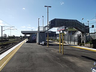
Yeerongpilly railway station is located on the Beenleigh line in Queensland, Australia. It serves the Brisbane suburb of Yeerongpilly. Immediately south-west of the station, the Corinda line branches off.

<span class="mw-page-title-main">Moorooka railway station</span> Railway station in Brisbane, Queensland, Australia

Moorooka railway station is located on the Beenleigh line in Queensland, Australia. It serves the Brisbane suburb of Moorooka. The station opened in 1887.

<span class="mw-page-title-main">Rocklea railway station</span> Railway station in Brisbane, Queensland, Australia

Rocklea railway station is located on the Beenleigh line in Queensland, Australia. It serves the Brisbane suburb of Rocklea. The station opened in 1885 at the same time as the line.

<span class="mw-page-title-main">Salisbury railway station, Brisbane</span> Railway station in Brisbane, Queensland, Australia

Salisbury railway station is located on the Beenleigh Line in Queensland, Australia. It serves the Brisbane suburb of Salisbury. The station opened in 1885 at the same time as the line.

<span class="mw-page-title-main">Banoon railway station</span> Railway station in Brisbane, Queensland, Australia

Banoon railway station is located on the Beenleigh line in Queensland, Australia. It is one of three stations serving the Brisbane suburb of Sunnybank, the others being Altandi and Sunnybank.

<span class="mw-page-title-main">Altandi railway station</span> Railway station in Brisbane, Queensland, Australia

Altandi railway station is located on the Beenleigh line in Queensland, Australia. It is one of three stations serving the Brisbane suburb of Sunnybank, the others being Sunnybank and Banoon.

<span class="mw-page-title-main">Kuraby railway station</span> Railway station in Brisbane, Queensland

Kuraby railway station is located on the Beenleigh line in Queensland, Australia. It serves the Brisbane suburb of Kuraby. Kuraby is the final station on the Beenleigh Line in the City of Brisbane, with the next station, Trinder Park, located in Logan City.

<span class="mw-page-title-main">Corinda–Yeerongpilly railway line</span> Railway line in Brisbane, Australia

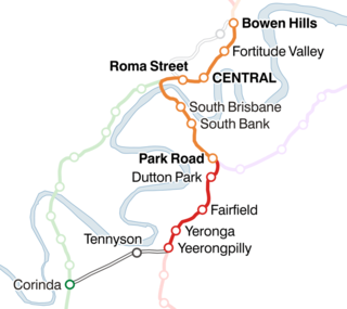
The Corinda–Yeerongpilly line is a railway line in Brisbane, the state capital of Queensland, Australia. It connects the Beenleigh and Ipswich lines for freight trains, but is no longer used for passenger services in normal operation.

<span class="mw-page-title-main">Yeerongpilly, Queensland</span> Suburb of Brisbane, Queensland, Australia

Yeerongpilly is a southern suburb in the City of Brisbane, Queensland, Australia. In the 2016 census, Yeerongpilly had a population of 1,934 people.

<span class="mw-page-title-main">Railways in South East Queensland</span>

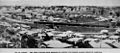
Brisbane, the capital city of the Australian state of Queensland, has a network of suburban railways that carry commuters, long-distance passengers, and freight. Suburban and interurban passenger services in Brisbane and South East Queensland are operated by the Queensland Rail Citytrain network, a branch of Queensland Rail. Queensland Rail also operates long-distance trains across the state. Aurizon and Pacific National operate freight services.

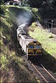
In the late 1970s and 1980s, a significant rail electrification program was completed in the Australian state of Queensland. The electrified Queensland network is the largest in Australia with over 2,000 kilometres electrified, the next biggest is New South Wales with 640 kilometres, that is served mainly as passenger operations.

<span class="mw-page-title-main">Cross River Rail</span> Proposed railway line in Brisbane, Queensland, Australia

Cross River Rail is an underground heavy rail project currently under construction in Brisbane, Queensland, Australia. The project will see the development of a new rail line underneath Brisbane River, alongside the redevelopment of a number of stations in the Brisbane central business district and along the Beenleigh railway line. The business case for the project was released in August 2017, with construction work officially beginning in September that year. The project replaced the planned 2013 BaT Tunnel, which in turn had replaced the original 2010 Cross River Rail proposal.

References

  1. "THE MINISTER FOR WORKS AT LOGANLEA". The Brisbane Courier . Vol. XXXIX, no. 8, 501. Queensland, Australia. 9 April 1885. p. 5. Retrieved 1 September 2020 via National Library of Australia.
  2. "Brisbane Suburb: Mount Gravatt - History of Mount Gravatt". ourbrisbane.com. 2000. Archived from the original on 21 January 2008. Retrieved 3 March 2008.
  3. Armstrong, J. & Kerr, J. 'Destination South Brisbane' ARHS 1978
  4. "THE FAIRFIELD DEVIATION". The Brisbane Courier. 7 August 1895.
  5. Kerr, J. 'Triumph of Narrow Gauge' Boolarong Publications 1990
  6. Stone, Lucy (2 August 2022). "Gold Coast, Beenleigh rail users face major changes as Brisbane's Cross River Rail network is revealed". ABC News. Australian Broadcasting Corporation . Retrieved 4 August 2022.