South Coast railway line, Queensland

Last updated

Map all coordinates using: OpenStreetMap
South Coast Line
StateLibQld 1 293367 Southport train at Tweed Heads Railway Station, 1940.jpg
Train at Tweed Heads in 1940
Overview
Owner Queensland Railways
Service
Operator(s)Queensland Railways
History
Opened25 January 1889 (to Southport)
10 August 1903 (to Tweed Heads)
Closed1 July 1961 (to Tweed Heads)
30 June 1964 (to Southport)
Technical
Line length73 kilometres
Track gauge 3 ft 6 in (1,067 mm)
Route map

Contents

showing distance (miles and chains)
from South Brisbane
BSicon KBHFa.svg
0 mi 0 ch
0 km
BSicon LSTR.svg
BSicon BHF.svg
24 mi 15 ch
38.93 km
BSicon exhKRZWae.svg
BSicon exHST.svg
26 mi 61 ch
43.07 km
BSicon exHST.svg
31 mi 16 ch
50.21 km
BSicon exHST.svg
33 mi 79 ch
54.7 km
BSicon exhKRZWae.svg
Pimpana Creek
BSicon exHST.svg
38 mi 35 ch
61.86 km
BSicon exhKRZWae.svg
BSicon exHST.svg
39 mi 35 ch
63.47 km
BSicon exhKRZWae.svg
Saltwater Creek
BSicon exHST.svg
40 mi 56 ch
65.5 km
BSicon exhKRZWae.svg
Coombabah Creek
BSicon exHST.svg
44 mi 54 ch
71.9 km
BSicon exTUNNEL1.svg
BSicon exHST.svg
46 mi 40 ch
74.83 km
BSicon exSTR+l.svg
BSicon exABZgr+r.svg
BSicon exSTR.svg
BSicon exTUNNEL1.svg
BSicon exSTR.svg
BSicon exKBHFe.svg
50 mi 10 ch
80.67 km
BSicon exHST.svg
48 mi
77 km
BSicon exhKRZWae.svg
BSicon exHST.svg
49 mi 11 ch
79.08 km
BSicon exHST.svg
53 mi 54 ch
86.38 km
BSicon exHST.svg
55 mi 33 ch
89.18 km
BSicon exTUNNEL1.svg
BSicon exHST.svg
61 mi
98 km
BSicon exhKRZWae.svg
BSicon exHST.svg
62 mi 70 ch
101.19 km
BSicon exhKRZWae.svg
BSicon exHST.svg
63 mi 79 ch
102.98 km
BSicon exHST.svg
67 mi 16 ch
108.15 km
BSicon exHST.svg
65 mi 46 ch
105.53 km
BSicon exHST.svg
68 mi 4 ch
109.52 km
BSicon exHST.svg
69 mi 7 ch
111.19 km
BSicon exSTR+GRZq.svg
BSicon exABZgl+l.svg
BSicon exENDEeq.svg
Turning wye
BSicon exKBHFe.svg
69 mi 33 ch
111.71 km

The South Coast railway line (also known as the Tweed railway line) was a railway from Brisbane, the capital city of Queensland, Australia. The route via the South Coast (now known as the Gold Coast) to Tweed Heads on the border of Queensland and New South Wales. The line operated from 1889 to 1964. The Gold Coast railway line re-opened in 1996 along a modified alignment in the north and a new route south but does not extend as far south yet as the South Coast line.

History

Flood damaged Logan River crossing, 1887 StateLibQld 1 254264 Flood damage to the Logan River railway bridge, looking from the Beenleight side, Beenleigh, 1887.jpg
Flood damaged Logan River crossing, 1887

The Beenleigh railway line opened in 1885 [1] before being extended 26 miles (42 km) from Beenleigh railway station to Southport in 1889. [2] The firm of J. W. Sutton and Company of Kangaroo Point in Brisbane provided materials and aided in bridge construction for the railway line. [3]

A branch line running 22 miles (35 km) from Southport Junction (later renamed Ernest Junction) to Tweed Heads opened on 10 August 1903. [4]

It had been hoped that the New South Wales Government would extend its Casino to Murwillumbah line a further 30 kilometres from Murwillumbah to Tweed Heads, but this did not occur due to cost of resuming the land and the expenses associated with the tunnel and bridge that would be required. [5]

Due to the increasing popularity of the motor car, and political interests in road transport, the Tweed Heads branch closed on 1 July 1961, followed by the Beenleigh to Southport line on 30 June 1964.

Stations

The initial South Coast line officially opened on 24 January 1889 [6] and included stops at:

Distance from South Brisbane railway stationStationCoordsNotes
Yatala Closed in 1891. [7]
Stapylton 27°44′21″S153°13′48″E / 27.739149°S 153.230014°E / -27.739149; 153.230014 (Stapylton railway station (former)) [8]
31 miles 16 chains (50.2 km) Ormeau 27°47′34″S153°15′55″E / 27.792725°S 153.265299°E / -27.792725; 153.265299 (Ormeau railway station (former)) [9] [10]
33 miles 79 chains (54.7 km) Pimpana 27°48′55″S153°17′32″E / 27.8152°S 153.2921°E / -27.8152; 153.2921 (Pimpama railway station (former)) [10] [11]
38 miles 35 chains (61.9 km) Coomera, 27°52′22″S153°18′46″E / 27.872830°S 153.312883°E / -27.872830; 153.312883 (Coomera railway station (former)) [10]
39 miles 27 chains (63.3 km)39 Mile Platform (Oxenford) 27°53′08″S153°18′55″E / 27.8855°S 153.3154°E / -27.8855; 153.3154 (Oxenford railway station) [10] [12]
40 miles 56 chains (65.5 km) Helensvale 27°53′54″S153°19′42″E / 27.898255°S 153.328348°E / -27.898255; 153.328348 (Helensvale railway station (former)) [10]
Coombabah 27°57′01″S153°20′46″E / 27.950143°S 153.346100°E / -27.950143; 153.346100 (Coombabah railway station) Closed in 1891. [7] [13]
46 miles 40 chains (74.8 km) Ernest Junction 27°58′12″S153°21′32″E / 27.970056°S 153.358775°E / -27.970056; 153.358775 (Ernest Junction railway station (former)) [10]
Unnamed 27°57′59″S153°23′10″E / 27.966329°S 153.386194°E / -27.966329; 153.386194 (Unnamed railway platform) [13]
Unnamed 27°58′02″S153°23′59″E / 27.967255°S 153.399823°E / -27.967255; 153.399823 (Unnamed railway platform) [13]
50 miles 10 chains (80.7 km) Southport 27°57′49″S153°24′40″E / 27.9637°S 153.4110°E / -27.9637; 153.4110 (Southport railway station (former)) [10] [14] [15]

It included a number of cuts, river crossings, long grades and a tunnel [16] at Ernest Junction that remains in situ (and is now heritage-listed). [17] The second branch of the South Coast line, known as the Nerang-Tweed Heads extension, [18] opened 14 September 1903 [19] [20] and stretched from Ernest Junction to the Queensland-New South Wales border. Stops included:

Distance from South Brisbane railway stationStationCoordsNotes
47 miles 61 chains (76.9 km) Molendinar 27°59′08″S153°21′22″E / 27.9855°S 153.3560°E / -27.9855; 153.3560 (Molendinar railway station (former)) Renamed from Benowa in October 1889. [21] [10] [22]
49 miles 11 chains (79.1 km) Nerang 27°59′43″S153°20′24″E / 27.9953°S 153.3401°E / -27.9953; 153.3401 (Nerang railway station (former)) [10] [23] [24]
53 miles 54 chains (86.4 km) Worongary [10]
55 miles 33 chains (89.2 km) Mudgeeraba [10]
Reedy Creek
61 miles 23 chains (98.6 km) West Burleigh 28°06′53″S153°26′30″E / 28.1147°S 153.4416°E / -28.1147; 153.4416 (West Burleigh (Booninbah) railway station (former)) On the western bank of Tallebudgera Creek roughly where the Pacific Highway crosses the creek today. [10] [25] Renamed from Booningba. [26]
62 miles 70 chains (101.2 km) Elanora 28°07′28″S153°27′52″E / 28.1245°S 153.4644°E / -28.1245; 153.4644 (Elanora railway station (former)) At the intersection of Palm Beach Avenue and the Pacific Highway [10] [25]
63 miles 79 chains (103.0 km) Currumbin 28°08′16″S153°28′23″E / 28.1378°S 153.4731°E / -28.1378; 153.4731 (Currumbin railway station (former)) On the eastern bank of Currumbin Creek. The current pedestrian bridge is the former railway bridge. [10] [25] [20]
65 miles 46 chains (105.5 km) Tugun 28°08′37″S153°29′40″E / 28.1435°S 153.49434°E / -28.1435; 153.49434 (Tugun railway station (former)) Roughly on the intersection of the Gold Coast Highway and Toolana Street. [10] [25]
67 miles 16 chains (108.1 km) Bilinga 28°09′36″S153°30′40″E / 28.1601°S 153.5110°E / -28.1601; 153.5110 (Bilinga railway station (former)) Roughly on the intersection of the Gold Coast Highway and George Street. [10] [25]
68 miles 4 chains (109.5 km) Kirra 28°10′11″S153°31′34″E / 28.1698°S 153.5262°E / -28.1698; 153.5262 (Kirra railway station (former)) Roughly at the intersection of Coolangatta Road and Haig Street. [10] [25]
69 miles 7 chains (111.2 km) Coolangatta 28°10′07″S153°32′12″E / 28.1685°S 153.5367°E / -28.1685; 153.5367 (Coolangatta railway station (former)) Griffith Street. [10] [14] [27]
69 miles 33 chains (111.7 km) Tweed Heads 28°10′19″S153°32′26″E / 28.1720°S 153.5405°E / -28.1720; 153.5405 (Tweed Heads railway station (former)) [10]

Route

From Beenleigh, coast-bound trains crossed the Old Pacific Highway three times between there and Yatala. In between these was the impressive Albert River crossing, made of three steel lattice girder spans. After passing Stapylton, the alignment was straight and of good standard, before reaching Ormeau. The alignment began to curve here, eventually reaching the Pimpama River and Pimpama Station. Coomera station was next, and a short distance later, the line crossed the Coomera River on a large bridge, similar to the Albert River bridge but with four spans instead of three. The southern floodplain of the river was crossed on timber trestles, leading to Oxenford. Passing Saltwater Creek, the line went through Helensvale, which had a small halt with little else but a nameboard signalling the station. After climbing nearly two miles, the railway passed through the curved Ernest Junction Tunnel. The station was just past here. The Southport branch continued on to Southport, but the Tweed Heads line continued onwards. Passing the small station of Molendinar, the line passed under the Southport-Nerang Road. The Nerang River bridge was next. Then came Nerang and Mudgeeraba stations, today covered by the busy Pacific Motorway. A tunnel was reached at West Burleigh, before arriving at the station of that name. After crossing Tallebudgera Creek bridge (now also demolished and replaced by the Pacific Motorway) travellers reached Elanora, then came the still extant Currumbin Creek bridge. From here, the route followed today's Stewart Street between Currumbin and Tugun, the Gold Coast Highway between Tugun and Kirra, Coolangatta Road between Kirra and Coolangatta, and Griffith Street over the border to Tweed Heads.

Services

Passenger trains ran from South Brisbane to Southport with connecting trains from Ernest Junction or Southport to Tweed Heads. Picnic and excursion trains ran through from South Brisbane to Tweed Heads on Sundays. [28] [29] [30]

From opening until around 1910, A12 and B13 class locos were the main motive power. From there until the 1950s, services were operated exclusively by PB15 class locomotives, the largest locomotive permitted to cross the Logan River. Diesel rail cars of the 1800 and 2000 classes operated some passenger services from the 1950s until closure in the 1960s. [31] [32]

Remains

A preserved piece of railway, where the route crossed Bay Street at Tweed Heads South Coast Rail at Tweed Heads NSW.jpg
A preserved piece of railway, where the route crossed Bay Street at Tweed Heads

Replacement

The Gold Coast railway line on a new alignment opened from Beenleigh to Helensvale in 1996, Nerang in 1997, Robina in 1998 and Varsity Lakes in 2009. [33]

See also

Related Research Articles

<span class="mw-page-title-main">Gold Coast, Queensland</span> Australian coastal city

The Gold Coast, often referred to by its initials G.C., and officially the City of Gold Coast, is a city in Queensland, Australia. It is Australia’s sixth-largest city, the most populous non-capital city, and the state's second-largest city after Brisbane, with a population over 600,000. The Gold Coast is a coastal city and region located approximately 66 kilometres (41 mi) south-southeast of the centre of the state capital, Brisbane. The city's central business district is located roughly in the centre of the Gold Coast in the suburb of Southport. The urban area of the Gold Coast is concentrated along the coast, sprawling almost 60 kilometres, joining up with the Greater Brisbane metropolitan region to the north and to the state border with New South Wales to the south. Nicknames of the city include the ‘Glitter Strip’ and the ‘Goldy’. The demonym of a Gold Coast resident is Gold Coaster.

<span class="mw-page-title-main">Coolangatta</span> Suburb of Gold Coast, Queensland, Australia

Coolangatta is a coastal suburb in the City of Gold Coast, Queensland, Australia. It is the Gold Coast's southernmost suburb and it borders New South Wales. In the 2016 census, Coolangatta had a population of 5,948 people.

<span class="mw-page-title-main">Beenleigh railway line</span> Suburban railway line in Brisbane, Australia

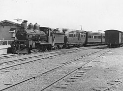
The Beenleigh railway line is a suburban railway line extending 40.1 km from Park Road railway station to Beenleigh railway station. It is part of the Queensland Rail Citytrain network.

<span class="mw-page-title-main">Gold Coast railway line</span> Connects Brisbane with the Queensland Gold Coast in Australia

The Gold Coast railway line is an interurban railway line operated by Queensland Rail in Queensland, Australia, connecting Brisbane with the Gold Coast. The line has 17 stations. In 2021, a journey from Central station to the terminus of this line was scheduled to take 1 hour 23 minutes. There are plans for several new stations along the existing line, as well as an extension south.

<span class="mw-page-title-main">Pacific Motorway (Brisbane–Brunswick Heads)</span> Motorway in New South Wales and Queensland

The Pacific Motorway is a motorway in Australia between Brisbane, Queensland, and Brunswick Heads, New South Wales, through the New South Wales–Queensland border at Tweed Heads.

<span class="mw-page-title-main">City of Gold Coast</span> Local government area in Queensland, Australia

The City of Gold Coast is the local government area spanning the Gold Coast, Queensland, Australia and surrounding areas. With a population of 606,774, it is the second most populous local government area in the State of Queensland. Its council maintains a staff of over 2,500. It was established in 1948, but has existed in its present form since 2008. It is on the border with New South Wales with the Tweed Shire to the south in New South Wales.

<span class="mw-page-title-main">History of the Gold Coast, Queensland</span>

The history of the Gold Coast in Queensland, Australia began in prehistoric times with archaeological evidence revealing occupation of the district by indigenous Australians for at least 23,000 years. The first early European colonizers began arriving in the late 1700s, settlement soon followed throughout the 19th century, and by 1959 the town was proclaimed a city. Today, the Gold Coast is one of the fastest-growing cities in Australia.

<span class="mw-page-title-main">Gold Coast Highway</span> Road in Queensland, Australia

Gold Coast Highway links the coastal suburbs of the Gold Coast in south eastern Queensland such as Miami, Mermaid Beach, Tugun, Bilinga and across the border of New South Wales to the Tweed Heads suburb of Tweed Heads West. At 39.6 kilometres (24.6 mi) in length, the highway runs just west of Pacific Motorway at Pacific Pines to Pacific Motorway at Tweed Heads West. It passes through the numerous popular tourist areas including Surfers Paradise and Broadbeach, a commercial centre at Southport, residential areas, shopping centres and the Gold Coast (Coolangatta) Airport.

The Shire of Tingalpa was a local government area in the south-eastern suburbs of Brisbane, Queensland, Australia. The shire, administered from Mount Cotton, covered an area of 120 square miles (311 km2), and existed as a local government entity from 1879 until 1949.

<span class="mw-page-title-main">Shire of Beenleigh</span> Former local government area in Queensland, Australia

The Shire of Beenleigh is a former local government area in the south-east of Queensland, Australia, centred on the town of Beenleigh. It existed from 1879 to 1949.

<span class="mw-page-title-main">Shire of Cleveland</span>

The Shire of Cleveland is a former local government area in the south-east of Queensland, Australia, centred on the town of Cleveland beside Moreton Bay.

The Shire of Waterford is a former local government area in the south-east of Queensland, Australia, centred on the town of Waterford. It existed between 1879 and 1948.

<span class="mw-page-title-main">Shire of Coomera</span> Local government area in South East Queensland, Australia

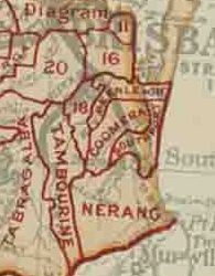
The Shire of Coomera was a local government area in South East Queensland, Australia. The shire, administered from Coomera, existed as a local government entity from 1879 until 1949.

<span class="mw-page-title-main">Shire of Nerang</span>

The Shire of Nerang was a local government area in South East Queensland, Australia. The shire existed as a local government entity from 1879 until 1949.

The Shire of Tamborine was a local government area in South East Queensland, Australia, centred on the village of Tamborine. It existed from 1890 to 1949.

<span class="mw-page-title-main">Town of Southport</span>

The Town of Southport was a local government area in South East Queensland, Australia.

<span class="mw-page-title-main">Town of Coolangatta</span>

The Town of Coolangatta was a local government area in South East Queensland, Australia, centred on Coolangatta. It existed from 1914 to 1949.

The Town of South Coast was a local government area in South East Queensland, Australia.

The following is a timeline of history of the city of Gold Coast, Queensland, Australia.

<span class="mw-page-title-main">Ernest Junction railway tunnel</span> Historic site in Queensland, Australia

Ernest Junction railway tunnel is a heritage-listed former railway tunnel at 797 Ashmore Road, Molendinar, Gold Coast City, Queensland, Australia. It was built from 1885 to 1889 by the Queensland Railway Department. It was added to the Queensland Heritage Register on 3 May 2019.

References

  1. History of Mt Gravatt Our Brisbane
  2. The Southport Railway Archived 27 April 2020 at the Wayback Machine Brisbane Courier 25 January 1889 page 6
  3. "Kangaroo Point: Iron Ships and Bridges". The Brisbane Courier . 24 May 1930. p. 22. Retrieved 24 January 2016 via National Library of Australia.
  4. Visitors from New South Wales Archived 27 April 2020 at the Wayback Machine The Brisbane Courier 11 August 1903 page 5
  5. Tweed Heads Railway Extension Archived 24 September 2020 at the Wayback Machine The Brisbane Courier 29 May 1903 page 5
  6. "The Southport Railway". The Brisbane Courier . Vol. XLV, no. 9, 682. 25 January 1889. p. 6. Archived from the original on 27 April 2020. Retrieved 9 May 2016 via National Library of Australia.
  7. 1 2 "Local and General". Logan Witness . Vol. XIII, no. 672. Queensland, Australia. 7 February 1891. p. 2 via National Library of Australia.
  8. Beenleigh, Queensland (Map) (2nd ed.). Royal Australian Survey Corps. 1947. Retrieved 29 October 2020.
  9. "Town of Ormeau" (Map). Queensland Government. 1971. Archived from the original on 5 April 2020. Retrieved 6 April 2020.
  10. 1 2 3 4 5 6 7 8 9 10 11 12 13 14 15 16 17 18 19 "Queensland Two Mile series sheet 2m37" (Map). historical-maps-qld.oldmapsonline.org. Department of Natural Resources, Mines and Energy. 1947. Retrieved 1 February 2024.
    "Untitled" (Map). Queensland Government. 1947. Archived from the original on 5 April 2020. Retrieved 6 April 2020.
  11. Tamborine Queensland (Map) (Second ed.). Royal Australian Survey Corps. 1954. Retrieved 30 October 2020.
    "Tamborine" (Map). Queensland Government. 1954. Archived from the original on 2 April 2020. Retrieved 20 April 2020.)
  12. "Parish of Barrow" (Map). Queensland Government. 1973. Archived from the original on 24 September 2020. Retrieved 19 April 2020.
  13. 1 2 3 Queensland. Department of Natural Resources and Mines (1887). Moreton 40 Chain map, sheet 11 south 1887 (Map). Department of Natural Resources and Mines. Archived from the original on 15 March 1961. Retrieved 27 January 2024.
  14. 1 2 "South Coast Rail Line". Archived from the original on 15 September 2014. Retrieved 15 September 2014.
  15. "Southport" (Map). Queensland Government. 1978. Archived from the original on 5 April 2020. Retrieved 6 April 2020.
  16. "Southport Railway". South Coast Bulletin . Vol. 8, no. 430. Queensland, Australia. 21 August 1936. p. 6. Archived from the original on 24 September 2020. Retrieved 9 May 2016 via National Library of Australia.
  17. "Ernest Junction Railway Tunnel (entry 650228)". Queensland Heritage Register . Queensland Heritage Council. Retrieved 25 April 2021.
  18. "Opening of Nerang Railway". Queensland Times, Ipswich Herald And General Advertiser . Vol. XLIV, no. 6642. 27 August 1903. p. 2. Retrieved 9 May 2016 via National Library of Australia.
  19. "Visitors From New South Wales". The Brisbane Courier . Vol. LX, no. 14, 220. 11 August 1903. p. 5. Archived from the original on 27 April 2020. Retrieved 9 May 2016 via National Library of Australia.
  20. 1 2 "Currumbin Creek Railway Bridge (former)" (PDF). Gold Coast City Council. Archived (PDF) from the original on 24 September 2020. Retrieved 24 September 2020.
  21. "Railway Station Names". The Telegraph (Brisbane) . No. 5, 295. Queensland, Australia. 2 October 1889. p. 4. Retrieved 11 October 2020 via National Library of Australia.
  22. Great Britain. War Office. General Staff. Australian Section, cartographer. (1926). Tambourine Queensland (Map). Scale 1:63,360. Australia 1:63,360. [Melbourne]: [Australian Section Imperial General Staff]. § 1 map : colour ; 44 x 78 cm, on sheet 56 x 83 cm. nla.obj-337985011. Retrieved 28 January 2024 via Trove.
    "Tambourine" (Map). Queensland Government. 1926. Archived from the original on 5 April 2020. Retrieved 5 April 2020.
  23. "Opening of Nerang Railway". Queensland Times, Ipswich Herald and General Advertiser . Vol. XLIV, no. 6642. 27 August 1903. p. 2. Retrieved 9 May 2016 via National Library of Australia.
  24. "Town of Nerang" (Map). Queensland Government. Archived from the original on 5 April 2020. Retrieved 5 April 2020.
  25. 1 2 3 4 5 6 "Moreton 40 Chain map AG2 series sheet 16 south". Queensland Government. 1929. Archived from the original on 24 September 2020. Retrieved 24 September 2020.
    Queensland. Survey Office (July 1929). Moreton 40 chain map. Sheet 16 South (Map). Gov't. Printer. Archived from the original on 24 April 1963. Retrieved 31 January 2024.
    Queensland. Department of Natural Resources and Mines (2006). Moreton 40 Chain map, sheet 16 south [Reproduction of 1929 edition] (Map). Department of Natural Resources and Mines. Retrieved 31 January 2024.
  26. "Burleigh and Beenleigh". The Brisbane Courier . No. 17, 747. Queensland, Australia. 1 December 1914. p. 6. Retrieved 30 October 2020 via National Library of Australia.
  27. "Tweed Heads" (Map). Queensland Government. 1943. Archived from the original on 5 April 2020. Retrieved 6 April 2020.
  28. "Southport Timetable". The Week . Vol. XXVII, no. 682. Brisbane. 12 January 1889. p. 26. Archived from the original on 24 September 2020. Retrieved 18 January 2018 via National Library of Australia.
  29. Nine Special Trains Booked for 4BH Picnic to Sourthport (21 October 1939). The Telegraph (Brisbane), p. 4 (Late Week End Final All the News). Retrieved 18 January 2018, from http://nla.gov.au/nla.news-article188037010
  30. "Tweed Heads-Brisbane Railway". Northern Star . Vol. 28. New South Wales, Australia. 24 October 1903. p. 8. Archived from the original on 28 September 2020. Retrieved 18 January 2018 via National Library of Australia.
  31. "Locomotives". The Telegraph . No. 16, 575 (5 O'clock City ed.). Brisbane. 15 January 1926. p. 12. Archived from the original on 24 September 2020. Retrieved 18 January 2018 via National Library of Australia.
  32. "1st Diesel run". The Courier-Mail . No. 4980. Brisbane. 13 November 1952. p. 3. Retrieved 18 January 2018 via National Library of Australia.
  33. Robina-Varsity Lakes rail extension state's most expensive The Courier-Mail 14 December 2009

Bibliography