Oxenford, Queensland

Last updated

Map all coordinates using: OpenStreetMap  
Download coordinates as: KML
Oxenford
Gold Coast,  Queensland
Oxenford Causeway.jpg
View from Old Tamborine Road overlooking the Coomera River
Australia Queensland location map.svg
Red pog.svg
Oxenford
Coordinates 27°54′22″S153°18′14″E / 27.9061°S 153.3038°E / -27.9061; 153.3038 (Oxenford (centre of suburb)) Coordinates: 27°54′22″S153°18′14″E / 27.9061°S 153.3038°E / -27.9061; 153.3038 (Oxenford (centre of suburb))
Population11,842 (2016 census) [1]
 • Density851.9/km2 (2,207/sq mi)
Postcode(s) 4210
Area13.9 km2 (5.4 sq mi)
Time zone AEST (UTC+10:00)
Location
LGA(s) City of Gold Coast
State electorate(s) Theodore
Federal division(s)
Suburbs around Oxenford:
Upper Coomera Upper Coomera Coomera
Maudsland Oxenford Helensvale
Maudsland Pacific Pines Gaven

Oxenford is a suburb in the City of Gold Coast, Queensland, Australia. [2] In the 2016 census, Oxenford had a population of 11,842 people. [1]

Contents

Geography

The suburb is bordered to the west and north by the Coomera River, to the east by the Pacific Motorway and to the south by Universal Street, Binstead Way, Kopps Road and the Gaven Arterial Road. [3]

The western edge of the suburb is also bordered by the Coomera River, which can only be crossed via the Coomera River causeway.[ citation needed ] Tamborine-Oxenford Road (State Route 95) runs through from west to north-east. [4]

The neighbourhood of Studio Village is the south of the suburb ( 27°55′09″S153°19′04″E / 27.9191°S 153.3177°E / -27.9191; 153.3177 (Studio Village) ). [5] It is adjacent to Wet'n'Wild Water World and Warner Bros. Movie World. [3] the subdivision's name itself was inspired by Movie World. [5] The street names in the subdivision refer to objects or people within Hollywood and film culture.[ citation needed ]

History

The suburb takes its name from the railway station which in turn was named after William Robert Oxenford, who purchased 160 acres (65 ha) in the Coomera district in 1869 and served for many years in the Coomera Shire Council. [6] [7] [8]

Oxenford Railway Station and Oxenford Railway Hotel Oxenford Railway Station and Oxenford Railway Hotel.jpg
Oxenford Railway Station and Oxenford Railway Hotel

The South Coast railway line was an extension of the Beenleigh railway line to Southport. The line opened on 24 January 1889 with Oxenford railway station (approx 27°53′08″S153°18′55″E / 27.8855°S 153.3154°E / -27.8855; 153.3154 (Oxenford railway station) ), [9] [10] originally named 39 Mile Platform because it was 39 miles (63 km) from the terminus at South Brisbane railway station. [11] The station was in use until 30 June 1964 when the line closed. When the modern Gold Coast railway line was built in 1996, the line did not pass through Oxenford but through Helensvale to the east and Helensvale railway station is the nearest station to Oxenford. [3] However, the Pacific Motorway roughly follows the route of the old South Coast railway line.

Work on the road south to Southport was undertaken in 1928. [12]

Oxenford State School opened on 27 January 1987. [13]

Gaven State School opened on 27 January 1995. [13]

In the 2016 census, Oxenford had a population of 11,842 people. [1]

According to the 2016 census of Population, there were 11,842 people in Oxenford. [1] Aboriginal and Torres Strait Islander people made up 1.7% of the population. 66.2% of people were born in Australia. The next most common countries of birth were New Zealand 10.0%, England 6.0% and South Africa 1.7%. 86.2% of people spoke only English at home. Other languages spoken at home included Mandarin at 1.0%. The most common responses for religion were No Religion 33.4%, Catholic 19.1% and Anglican 18.5%. [1]

Education

Oxenford State School is a government primary (Prep-6) school for boys and girls at 90 Michigan Drive ( 27°53′58″S153°18′14″E / 27.8994°S 153.3039°E / -27.8994; 153.3039 (Oxenford State School) ). [14] [15] In 2017, the school had an enrolment of 559 students with 41 teachers (35 full-time equivalent) and 23 non-teaching staff (15 full-time equivalent). [16] It includes a special education program. [14]

Gaven State School is a government primary (Prep-6) school for boys and girls at Universal Street ( 27°55′11″S153°18′18″E / 27.9196°S 153.3051°E / -27.9196; 153.3051 (Gaven State School) ). [14] [17] In 2017, the school had an enrolment of 694 students with 50 teachers (43 full-time equivalent) and 35 non-teaching staff (27 full-time equivalent). [16] It includes a special education program. [14]

There are no secondary schools in Oxenford. The nearest secondary schools are Helensvale State High School in Helensvale and Pacific Pines State High School in Pacific Pines. [3]

Community groups

The Coomera branch of the Queensland Country Women's Association meets at the 161 Maudsland Road ( 27°54′51″S153°16′58″E / 27.9142°S 153.2829°E / -27.9142; 153.2829 (Coomera Country Women's Association) ). [18]

There is a Neighbourhood Watch group in Oxenford. [19]

Attractions

Theme parks Warner Bros. Movie World ( 27°54′25″S153°18′47″E / 27.907°S 153.313°E / -27.907; 153.313 (Warner Bros. Movie World) ) and Wet'n'Wild Water World ( 27°54′54″S153°19′05″E / 27.915°S 153.318°E / -27.915; 153.318 (Wet'n'Wild Water World) ) are located within Oxenford's boundaries.

Related Research Articles

<span class="mw-page-title-main">Gold Coast, Queensland</span> City in Queensland, Australia

The Gold Coast is a coastal city in the state of Queensland, Australia, approximately 66 kilometres (41 mi) south-southeast of the centre of the state capital Brisbane and immediately north of the border with New South Wales. The area was previously occupied prior to European settlement by the Yugambeh language people. The demonym for the Gold Coast is Gold Coaster. With an estimated population of 679,127 in June 2018, the Gold Coast is the sixth-largest city in Australia, Australia's largest non-capital city, and Queensland's second-largest city.

<span class="mw-page-title-main">Gold Coast railway line</span>

The Gold Coast railway line is an interurban railway line operated by Queensland Rail in Queensland, Australia, connecting Brisbane with the Gold Coast. The line currently includes stops at 17 stations. In 2021, a journey from Central station to the terminus of this line is scheduled to take 1 hour 23 minutes. Several new stations along the existing line and an extension south are planned.

<span class="mw-page-title-main">Southport, Queensland</span> Suburb of Gold Coast, Queensland, Australia

Southport is a coastal suburb in the City of Gold Coast in Queensland, Australia. In the 2016 census, Southport had a population of 31,908 people. It contains the Gold Coast central business district.

<span class="mw-page-title-main">Pacific Motorway (Brisbane–Brunswick Heads)</span> Motorway in New South Wales and Queensland

The Pacific Motorway is a motorway in Australia between Brisbane, Queensland, and Brunswick Heads, New South Wales, through the New South Wales–Queensland border at Tweed Heads.

<span class="mw-page-title-main">Coomera railway station</span> Railway statii on the Gold Coast railway line

Coomera railway station is located on the Gold Coast line in Queensland, Australia. It serves the Gold Coast suburb of Coomera.

<span class="mw-page-title-main">Helensvale railway station</span> Railway station in Queensland, Australia

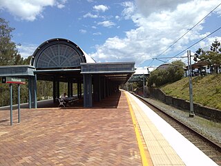
Helensvale railway station is a major public transport interchange in the Gold Coast suburb of Helensvale. Helensvale railway station is served by the Queensland Rail Citytrain network Gold Coast line, G:link light rail and Surfside Buslines bus services.

<span class="mw-page-title-main">Helensvale, Queensland</span> Suburb of Gold Coast, Queensland, Australia

Helensvale is a suburb of the City of Gold Coast in Queensland, Australia. In the 2016 census, Helensvale had a population of 16,862 people.

<span class="mw-page-title-main">Hope Island, Queensland</span> Suburb of Gold Coast, Queensland, Australia

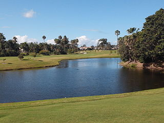
Hope Island is a suburb in the City of Gold Coast, Queensland, Australia. In the 2016 census, Hope Island had a population of 11,186 people.

<span class="mw-page-title-main">South Coast railway line, Queensland</span>

The South Coast railway line was a railway from Brisbane, the capital city of Queensland, Australia. The route via the South Coast to Tweed Heads on the border of Queensland and New South Wales. The line operated from 1889 to 1964. The Gold Coast railway line re-opened in 1996 along a modified alignment in the north and a new route south but does not extend as far south yet as the South Coast line.

<span class="mw-page-title-main">Transport on the Gold Coast, Queensland</span>

The Gold Coast is the largest regional city and fastest growing city in Australia. As a result, the Gold Coast has a wide range of public and private transport options from cars and bikes to buses, heavy rail and light rail. The car is the dominant mode of transport in the city with an extensive arterial road network that connects the standard residential streets with major suburbs and motorways.

<span class="mw-page-title-main">Parkwood, Queensland</span> Suburb of Gold Coast, Queensland, Australia

Parkwood is a suburb in the City of Gold Coast, Queensland, Australia. In the 2016 census, Parkwood had a population of 8,702 people.

<span class="mw-page-title-main">Upper Coomera, Queensland</span> Suburb of City of Gold Coast, Queensland, Australia

Upper Coomera is a suburb in the City of Gold Coast, Queensland, Australia. In the 2016 census, Upper Coomera had a population of 25,276 people.

Pimpama is a northern suburb in the City of Gold Coast, Queensland, Australia. In the 2016 census, Pimpama had a population of 9,396 people. The name is of Aboriginal origin. The suburb contains numerous schools with the first opening in the 1870s.

<span class="mw-page-title-main">Arundel, Queensland</span> Suburb of Gold Coast, Queensland, Australia

Arundel is a suburb in the City of Gold Coast, Queensland, Australia. In the 2016 census, Arundel had a population of 10,246 people.

<span class="mw-page-title-main">Coomera, Queensland</span> Town in Queensland, Australia

Coomera is a town and suburb in the City of Gold Coast, Queensland, Australia. In the 2016 census, Coomera had a population of 13,305 people.

Gaven is a rural residential locality in the City of Gold Coast, Queensland, Australia. In the 2016 census, Gaven had a population of 1,558 people.

<span class="mw-page-title-main">Maudsland, Queensland</span> Suburb of City of Gold Coast, Queensland, Australia

Maudsland is a rural-residential locality in the north of the City of Gold Coast, Queensland, Australia. In the 2016 census, Maudsland had a population of 5,568 people.

<span class="mw-page-title-main">Wongawallan, Queensland</span> Suburb of City of Gold Coast, Queensland, Australia

Wongawallan is a rural locality in the City of Gold Coast, Queensland, Australia. In the 2016 census Wongawallan had a population of 1,273 people.

<span class="mw-page-title-main">Hope Island railway station</span> A planned train station in Helensvale, Queensland.

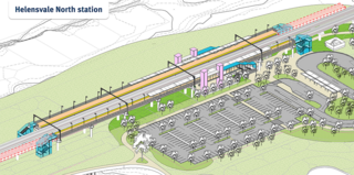
Hope Island railway station is a planned railway station on the Gold Coast Line in Queensland, Australia. It will serve the Gold Coast suburbs of Helensvale, Hope Island and Oxenford, and will be located between Coomera and Helensvale stations.

References

  1. 1 2 3 4 5 Australian Bureau of Statistics (27 June 2017). "Oxenford (SSC)". 2016 Census QuickStats. Retrieved 20 October 2018. OOjs UI icon edit-ltr-progressive.svg
  2. "Oxenford – suburb in City of Gold Coast (entry 46075)". Queensland Place Names. Queensland Government . Retrieved 26 January 2020.
  3. 1 2 3 4 "Queensland Globe". State of Queensland . Retrieved 5 October 2020.
  4. Google (4 October 2022). "Oxenford, Queensland" (Map). Google Maps . Google. Retrieved 4 October 2022.
  5. 1 2 "Studio Village – neighbourhood in City of Gold Coast (entry 39101)". Queensland Place Names. Queensland Government . Retrieved 18 September 2020.
  6. "CROWN LAND SELECTIONS". The Brisbane Courier . Queensland, Australia. 7 July 1869. p. 3. Retrieved 19 April 2020 via Trove.
  7. "REPRESENTATIVE MEN.--XI". The Brisbane Courier . Queensland, Australia. 22 June 1907. p. 13. Archived from the original on 5 October 2020. Retrieved 19 April 2020 via Trove.
  8. "PERSONAL". The Brisbane Courier . Queensland, Australia. 5 April 1919. p. 15. Archived from the original on 5 October 2020. Retrieved 19 April 2020 via Trove.
  9. "Untitled" (Map). Queensland Government. 1947. Archived from the original on 5 April 2020. Retrieved 6 April 2020.
  10. "Parish of Barrow" (Map). Queensland Government. 1973. Archived from the original on 24 September 2020. Retrieved 19 April 2020.
  11. "THE SOUTHPORT RAILWAY". The Brisbane Courier . Vol. XLV, no. 9, 682. 25 January 1889. p. 6. Archived from the original on 27 April 2020. Retrieved 9 May 2016 via National Library of Australia.
  12. "Southport Road". The Telegraph (Brisbane, Qld. : 1872 - 1947) . Brisbane, Qld.: National Library of Australia. 10 April 1928. p. 15 Edition: 5 O'CLOCK CITY EDITION. Archived from the original on 5 October 2020. Retrieved 23 January 2016.
  13. 1 2 Queensland Family History Society (2010), Queensland schools past and present (Version 1.01 ed.), Queensland Family History Society, ISBN   978-1-921171-26-0
  14. 1 2 3 4 "State and non-state school details". Queensland Government. 9 July 2018. Archived from the original on 21 November 2018. Retrieved 21 November 2018.
  15. "Oxenford State School". Archived from the original on 4 February 2014. Retrieved 21 November 2018.
  16. 1 2 "ACARA School Profile 2017". Archived from the original on 22 November 2018. Retrieved 22 November 2018.
  17. "Gaven State School". Archived from the original on 26 January 2014. Retrieved 21 November 2018.
  18. "Branch Locations". Queensland Country Women's Association. Archived from the original on 26 December 2018. Retrieved 26 December 2018.
  19. "Oxenford Neighbourhood Watch". Archived from the original on 25 February 2020. Retrieved 5 October 2020.