Mount Edwards railway line

Last updated

Map all coordinates using: OpenStreetMap
Mount Edwards railway line
BSicon exKBHFa.svg
25km
Mount Edwards railway station
BSicon exHST.svg
19km
Aratula railway station
BSicon exBST.svg
17km
Morwincha railway station
BSicon exHST.svg
14km
Fassifern Valley railway station
BSicon exHST.svg
12km
Warumkarie railway station
BSicon exHST.svg
9km
Kalbar railway station
BSicon exHST.svg
4km
Waraperta railway station
BSicon exLSTRq.svg
BSicon exABZql.svg
BSicon exLSTRq.svg
0km
Dugandan Line at Munbilla

The Mount Edwards railway line was a branch railway in the Scenic Rim region of South East Queensland, Australia. The lines serves a number of small towns in the Fassifern Valley. The first stage of the Mount Edwards line opened from Munbilla to Engelsburg (now Kalbar) on 17 April 1916, but the next stage to Mount Edwards was not completed until 7 October 1922. [1] The line closed on 1 November 1960. [2] [3]

Contents

Geography

The 25 km long line branched off the Dugandan line at the rural locality of Munbilla 38 km south of the city of Ipswich. The line then proceeded in a generally south-westerly direction to the locality of Mount Edwards near the village of Aratula.

History

The line was intended to form part of a via recta (Latin, "straight route") between Brisbane and Sydney via the break-of-gauge border town of Wallangarra. Before the completion of the New South Wales North Coast Line in 1930, rail traffic between the two state capitals travelled west from Brisbane to Toowoomba then south to Wallangarra via Warwick. The via recta was to incorporate the Mount Edwards line and the Maryvale line on the other side of the Great Dividing Range to produce a direct route southwest from Brisbane to Warwick, shaving around 95 km off the interstate journey. However, the via recta was never completed. [2]

Route

Stations on the Mount Edwards railway line
Distance from IpswichNameCoordinatesAltitudeNotes
Junction with Dugundan line 27°52′17″S152°39′23″E / 27.8714°S 152.6563°E / -27.8714; 152.6563 (Junction with Mount Edwards line) Immediately south-west of Munbilla railway station. [4] [5]
26 miles 56 chains (43.0 km) Warperta 27°54′12″S152°37′58″E / 27.90333°S 152.63278°E / -27.90333; 152.63278 (Waraperta railway station (former)) 247 feet (75 m)On Munbillla Road (now in Kents Lagoon). [4] [5] [6]
29 miles 39 chains (47.5 km) Kalbar 27°56′21″S152°37′15″E / 27.93924°S 152.62090°E / -27.93924; 152.62090 (Kalbar railway station (former)) 262 feet (80 m)At the western end of Railway Street in Kalbar. [4] [5]
31 miles 34 chains (50.6 km) Warumkarie 27°57′26″S152°36′39″E / 27.95715°S 152.61082°E / -27.95715; 152.61082 (Warumkarie railway station (former)) 308 feet (94 m)On Warumkarie Road (now in the south of Kalbar). [4] [5]
32 miles 60 chains (52.7 km) Fassifern Valley 27°58′23″S152°35′59″E / 27.97297°S 152.59979°E / -27.97297; 152.59979 (Fassifern Valley railway station) 295 feet (90 m)On Lake Moogerah Road. [4] [5]
34 miles 30 chains (55.3 km) Morwincha 27°58′23″S152°34′38″E / 27.97299°S 152.57734°E / -27.97299; 152.57734 (Morwincha railway station (former)) 312 feet (95 m)On the bend in Morwincha Road. [4]
36 miles 2 chains (58.0 km) Aratula 27°58′57″S152°33′16″E / 27.98252°S 152.55450°E / -27.98252; 152.55450 (Aratula railway station (former)) 357 feet (109 m)At the eastern end of Sawmill Road. [4] [5]
39 miles 70 chains (64.2 km) Mount Edwards 28°01′17″S152°30′57″E / 28.02136°S 152.51578°E / -28.02136; 152.51578 (Mount Edwards railway station (former)) 621 feet (189 m)Terminus, on the southern corner of the Cunningham Highway and Lake Moogerah Road [4] [5]

See also

Related Research Articles

<span class="mw-page-title-main">Wallangarra, Queensland</span> Town in Queensland, Australia

Wallangarra is a rural town and locality in the Southern Downs Region, Queensland, Australia on the border with New South Wales. In the 2016 census, the locality of Wallangarra had a population of 468 people.

<span class="mw-page-title-main">Aratula</span> Town in Queensland, Australia

Aratula is a rural town and locality in the Scenic Rim Region, Queensland, Australia. In the 2016 census, the locality of Aratula had a population of 532 people.

<span class="mw-page-title-main">Rail transport in Queensland</span>

The rail network in Queensland, Australia, was the first in the world to adopt 1,067 mm narrow gauge for a main line, and, in 2013, was claimed to the second largest narrow gauge network in the world, consists of:

<span class="mw-page-title-main">Inland Rail</span> Railway line under construction in Australia

Inland Rail, also known as Inland Railway and previously Australian Inland Railway Expressway, is a 1600-kilometre (990 mi) railway line under construction in Australia. Once complete, it will connect the ports of Melbourne and Brisbane along a new route west of the mountainous Great Dividing Range, bypassing the busy Sydney metropolitan area and allowing for the use of double-stacked freight trains. The route will also connect to the Sydney–Perth rail corridor, reducing journey times between Brisbane, Adelaide and Perth.

<span class="mw-page-title-main">Killarney railway line</span> Former railway line in Queensland

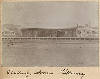
The Killarney railway line was a branch railway in the Darling Downs region of Queensland, Australia. It travelled from Warwick to Killarney and operated from 1884 to 1964.

The Maryvale railway line was a branch railway in the Southern Downs region of Queensland, Australia.

<span class="mw-page-title-main">Southern railway line, Queensland</span> Railway line in Queensland, Australia

The Southern railway line serves the Darling Downs region of Queensland, Australia. The 197-kilometre (122 mi) long line branches from the Western line at Toowoomba, 161 kilometres (100 mi) west of Brisbane, and proceeds south through Warwick and Stanthorpe to the New South Wales/Queensland state border at Wallangarra.

<span class="mw-page-title-main">Maryvale, Queensland (Southern Downs Region)</span> Town in Queensland, Australia

Maryvale is a rural town and locality in the Southern Downs Region, Queensland, Australia. In the 2016 census, the locality of Maryvale had a population of 303 people.

<span class="mw-page-title-main">Dugandan railway line</span> Railway line in Queensland, Australia

The Dugandan railway line was a branch railway in the Scenic Rim region of South East Queensland, Australia. It was also known as the Fassifern railway line. It operated from 1882 to 1964.

<span class="mw-page-title-main">Kalbar, Queensland</span> Town in Queensland, Australia

Kalbar is a rural town and locality in the Scenic Rim Region, Queensland, Australia. In the 2016 census, the locality of Kalbar had a population of 1,093 people.

<span class="mw-page-title-main">Main Line railway, Queensland</span> Railway line in Queensland, Australia

The Main Line is a railway line in South East Queensland, Australia. It was opened in a series of sections between 1865 and 1867. It commences at Roma St Station in Brisbane and extends west 161 km to Toowoomba. It is the first narrow gauge main line constructed in the world. The section of the line from the end of Murphys Creek railway station to the Ruthven Street overbridge, Harlaxton is listed on the Queensland Heritage Register. The Murphys Creek Railway Complex, the Lockyer Creek Railway Bridge (Lockyer), the Lockyer Creek Railway Bridge and Swansons Rail Bridge are also heritage listed.

<span class="mw-page-title-main">Munbilla, Queensland</span> Town in Queensland, Australia

Munbilla is a rural town and locality in the Scenic Rim Region, Queensland, Australia. In the 2016 census, the locality of Munbilla had a population of 100 people.

<span class="mw-page-title-main">Wallangarra railway station</span> Historic site in Queensland, Australia

Wallangarra railway station is a heritage-listed railway station at Woodlawn Street, Wallangarra, Southern Downs Region, Queensland, Australia. It was built in 1877 along the state border of Queensland and New South Wales It was added to the Queensland Heritage Register on 28 March 2003.

<span class="mw-page-title-main">Kents Lagoon, Queensland</span> Suburb of Scenic Rim Region, Queensland, Australia

Kents Lagoon is a rural locality in the Scenic Rim Region, Queensland, Australia. In the 2016 census, Kents Lagoon had a population of 56 people.

<span class="mw-page-title-main">Fassifern Valley, Queensland</span> Suburb of Scenic Rim Region, Queensland, Australia

Fassifern Valley is a rural locality in the Scenic Rim Region, Queensland, Australia. In the 2016 census, Fassifern Valley had a population of 91 people.

<span class="mw-page-title-main">Clintonvale, Queensland</span> Suburb of Southern Downs Region, Queensland, Australia

Clintonvale is a rural locality in the Southern Downs Region, Queensland, Australia. In the 2016 census, Clintonvale had a population of 74 people.

<span class="mw-page-title-main">Clumber, Queensland</span> Suburb of Scenic Rim Region, Queensland, Australia

Clumber is a rural locality in the Scenic Rim Region, Queensland, Australia. In the 2016 census, Clumber had a population of 60 people.

<span class="mw-page-title-main">Mount Edwards, Queensland</span> Suburb of Scenic Rim Region, Queensland, Australia

Mount Edwards is a rural locality in the Scenic Rim Region, Queensland, Australia. In the 2016 census, Mount Edwards had a population of 63 people.

Morwincha is a rural locality in the Scenic Rim Region, Queensland, Australia. In the 2016 census, Morwincha had a population of 30 people.

References

  1. Kerr, John (1990). Triumph of narrow gauge : a history of Queensland Railways. Boolarong Publications. p. 224. ISBN   978-0-86439-102-5.
  2. 1 2 Southern Downs Steam Railway (2009). "'Via recta' – The line that never was". Archived from the original on 12 September 2009. Retrieved 25 October 2009.
  3. QR Limited. "Rail as foremost mode of travel". Archived from the original on 12 September 2009. Retrieved 25 October 2009.
  4. 1 2 3 4 5 6 7 8 "Queensland Two Mile series sheet 2m38" (Map). Queensland Government. 1955. Archived from the original on 21 June 2021. Retrieved 4 January 2022.
  5. 1 2 3 4 5 6 7 "Flinders" (Map). Queensland Government. 1927. Archived from the original on 29 May 2020. Retrieved 2 January 2021.
  6. "Warperta – railway station (now absent) in Scenic Rim Region (entry 39340)". Queensland Place Names. Queensland Government . Retrieved 4 January 2022.