
Palmwoods is a rural town and locality in the Sunshine Coast Region, Queensland, Australia. In the 2021 census, the locality of Palmwoods had a population of 6,357 people.
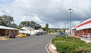
Proston is a rural town and locality in the South Burnett Region, Queensland, Australia. In the 2021 census, the locality of Proston had a population of 410 people.
Helidon is a rural town and locality in the Lockyer Valley Region, Queensland, Australia. In the 2021 census, the locality of Helidon had a population of 1,130 people.
Hivesville is a rural town and locality in the South Burnett Region, Queensland, Australia. In the 2021 census, the locality of Hivesville had a population of 173 people.
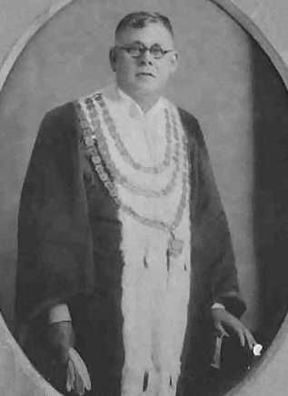
Alfred James Jones was an Australian politician who served as a Member of the Queensland Legislative Assembly, a Member of the Queensland Legislative Council and as Lord Mayor of Brisbane.

The Mount Perry Branch Railway is a closed railway line in Central Queensland, Australia. In 1869 copper was discovered at Mount Perry and the township grew rapidly. A railway to the coast was essential to provide cheap transport and make the mining of low percentage ore viable. Maryborough and Bundaberg vied for the opportunity to be the terminus and the latter city was successful.
Haden Branch Railway was a branch railway line from Kingsthorpe to Goombungee and Haden in the Darling Downs, Queensland, Australia.

The Nanango railway line was a narrow-gauge branch railway located in Queensland, Australia. On 31 October 1882, parliament approved the construction of a branch line from Theebine west to Kilkivan after gold and copper were discovered in this region of Queensland, Australia. The section was opened in two stages – to Dickabram on 1 January 1886 after two crossings of the Mary River and to Kilkivan on 6 December 1886.

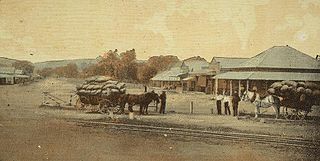
The Proston railway line was a branch railway from Murgon to Proston in south-east Queensland, Australia.

The Beaudesert Shire Tramway was a narrow gauge tramway which operated from Beaudesert to Lamington and Rathdowney in the Scenic Rim Region, Queensland, Australia, It was one of 15 light railways built and operated by Divisional Boards and Shire Councils in Queensland. The line carried passengers and cargo. It operated from 1903 to 1944. It was initially profitable and seen as a great success for the local shire council. The tramway is credited with opening up the agricultural lands of the upper Logan River.

The Queensland Country Women's Association (QCWA) is the Queensland chapter of the Country Women's Association in Australia. The association seeks to serve the interests of women and children in rural areas in Australia through a network of local branches. Established in 1922, local branches provide friendship and mutual support to their members while contributing to the betterment of life in their local communities. Over time, many branches have evolved to include support for wider issues such as domestic violence campaigns and fund-raising for international initiatives such as orphanages.
Cloyna is a rural locality in the South Burnett Region, Queensland, Australia. In the 2021 census, Cloyna had a population of 160 people.
Barlil is a rural locality in the South Burnett Region, Queensland, Australia. In the 2021 census, Barlil had a population of 46 people.
Windera is a town in the South Burnett Region and a locality split between the South Burnett Region and the Gympie Region in Queensland, Australia. In the 2021 census, the locality of Windera had a population of 105 people.
Leafdale is a rural locality in the South Burnett Region, Queensland, Australia. In the 2021 census, Leafdale had a population of 12 people.
Morganville is a rural locality in the Bundaberg Region, Queensland, Australia.
Stalworth is a rural locality in the South Burnett Region, Queensland, Australia. In the 2021 census, Stalworth had a population of 37 people.
Mount Lawless is a rural locality in the North Burnett Region, Queensland, Australia. In the 2021 census, Mount Lawless had a population of 9 people.
Byee is a rural locality in the South Burnett Region, Queensland, Australia. In the 2021 census, Byee had a population of 39 people.
Sabine is a rural locality in the Toowoomba Region, Queensland, Australia. In the 2021 census, Sabine had "no people or a very low population".