Related Research Articles

Cloncurry is a town and locality in the Shire of Cloncurry, Queensland, Australia. It is the administrative centre of the shire. At the 2016 census, Cloncurry recorded a population of 2,719 people.

Croydon is a town and locality within the Shire of Croydon in Queensland, Australia. It is a terminus for the Normanton to Croydon railway line, which operates the Gulflander tourist train. At the 2016 census, Croydon had a population of 258 people.

The City of Mount Isa is a local government area in north west Queensland. The City covers the urban locality of Mount Isa, the administrative centre, and surrounding area, sharing a boundary with the Northern Territory to the west.

Dajarra is a town and a locality in the Shire of Cloncurry, Queensland, Australia. In the 2016 census, Dajarra had a population of 191 people.

Julia Creek is a town and a locality in the Shire of Mckinlay, Queensland, Australia. At the 2016 census, Julia Creek had a population of 511.
Doomadgee is a town and a locality in the Aboriginal Shire of Doomadgee, Queensland, Australia. In the 2016 census, Doomadgee had a population of 1405 people.

The Shire of Cloncurry is a local government area in North West Queensland, Australia. It covers an area of 47,971 square kilometres (18,521.7 sq mi), and has existed as a local government entity since 1884. The major town and administrative centre of the shire is Cloncurry.
Ballara is the site of a deserted mining town in the locality of Kuridala in north-western Queensland, Australia, in the Selwyn Range between the towns of Mount Isa and Cloncurry. It is within the local government area of Shire of Cloncurry.
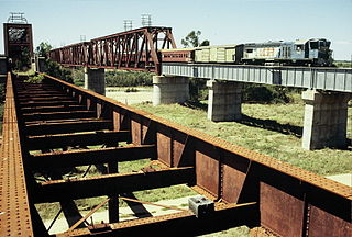
The Great Northern Railway is a 1,067 mm railway line in Queensland, Australia. The line stretches nearly 1,000 kilometres linking the port city of Townsville, Australia to the mining town of Mount Isa in north-west Queensland. Along with a passenger service called the Inlander, it is a major freight route connecting the Mount Isa Mines to the Townsville Port. In 2010 the line moved 5.8 million tonnes of cargo, and this is expected to increase significantly in coming years.
Kajabbi is a town in the locality of Three Rivers, Shire of Cloncurry, Queensland, Australia.
Duchess is a rural town and locality in the Shire of Cloncurry, Queensland, Australia. In the 2016 census, Duchess had a population of 23 people.

The Cloncurry River is situated in the Gulf Country of north west Queensland, Australia.
The Great Western Railway was a railway development proposal involving a total of five new lines in western Queensland, Australia. Construction started in 1911 on sections of four of the lines, and three were opened in part before the project was effectively abandoned in 1920.
Mount Cuthbert is a former copper mining town in the locality of Three Rivers, Shire of Cloncurry, Queensland, Australia. It is now a ghost town.
Selwyn is a town and locality in the Shire of Cloncurry, Queensland, Australia. Selwyn is a now-abandoned mining town.

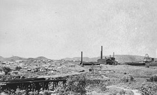
Kuridala Township site is a heritage-listed mining camp in the locality of Kuridala, Shire of Cloncurry, Queensland, Australia. It was built from 1880s to 1920s. It is also known as Hampden Township, Hampden Smelter, Kuridala Smelter, and Friezeland Township. It was added to the Queensland Heritage Register on 12 June 2009.
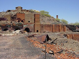
Mount Elliott Mining Complex is a heritage-listed copper mine and smelter at Selwyn, Shire of Cloncurry, Queensland, Australia. It was designed by William Henry Corbould and built in 1908. It is also known as Mount Elliott Smelter and Selwyn. It was added to the Queensland Heritage Register on 16 September 2011.
Malbon is a town in the locality of Kuridala in the Shire of Cloncurry, Queensland, Australia.
Kunwarara is a rural locality in the Livingstone Shire, Queensland, Australia. In the 2016 census, Kunwarara had a population of 71 people.
Mount Isa is a rural locality in the City of Mount Isa, Queensland, Australia. It is the land that surrounds the suburbs of Mount Isa. In the 2016 census, the locality of Mount Isa had a population of 118 people.
References
- "Triumph of Narrow Gauge: A History of Queensland Railways" by John Kerr 1990 Boolarong Press, Brisbane.
- ↑ "Cloncurry - railway station in the Shire of Cloncurry (entry 7471)". Queensland Place Names. Queensland Government . Retrieved 11 September 2020.
- ↑ "Malbon - railway station in the Shire of Cloncurry (entry 20693)". Queensland Place Names. Queensland Government . Retrieved 11 September 2020.
- ↑ "Dolomite - railway station in Shire of Cloncurry (entry 10280)". Queensland Place Names. Queensland Government . Retrieved 11 September 2020.
- ↑ "Marimo - railway station in the Shire of Cloncurry (entry 20993)". Queensland Place Names. Queensland Government . Retrieved 11 September 2020.
- ↑ "Mitakoodi - railway station in the Shire of Cloncurry (entry 22359)". Queensland Place Names. Queensland Government . Retrieved 11 September 2020.
- ↑ "Marraba - unbounded locality in Shire of Cloncurry (entry 21076)". Queensland Place Names. Queensland Government . Retrieved 11 September 2020.
- 1 2 3 "Queensland Globe". State of Queensland . Retrieved 10 September 2020.
- ↑ "Kuridala (entry 44673)". Queensland Place Names. Queensland Government . Retrieved 4 September 2015.
- ↑ "Selwyn (entry 30388)". Queensland Place Names. Queensland Government . Retrieved 4 September 2015.
- ↑ "Kundora - unbounded locality in the Shire of Cloncurry (entry 39280)". Queensland Place Names. Queensland Government . Retrieved 11 September 2020.
- ↑ "Devoncourt - unbounded locality in the Cloncurry Shire (entry 9838)". Queensland Place Names. Queensland Government . Retrieved 11 September 2020.
- ↑ "Wammutta - railway station in the Shire of Cloncurry (entry 36409)". Queensland Place Names. Queensland Government . Retrieved 11 September 2020.
- ↑ "Dronfield - railway station in the Shire of Cloncurry (entry 10557)". Queensland Place Names. Queensland Government . Retrieved 11 September 2020.
- ↑ "Bungalien - railway station in the Shire of Cloncurry (entry 5244)". Queensland Place Names. Queensland Government . Retrieved 11 September 2020.
- ↑ "Duchess" (Map). Queensland Government. 1943. Retrieved 11 September 2020.
- ↑ "Dajarra - population centre in the Shire of Cloncurry (entry 9202)". Queensland Place Names. Queensland Government . Retrieved 11 September 2020.