
Mount Isa is a city in the Gulf Country region of Queensland, Australia. It came into existence because of the vast mineral deposits found in the area. Mount Isa Mines (MIM) is one of the most productive single mines in world history, based on combined production of lead, silver, copper and zinc.

Cloncurry is a rural town and locality in the Shire of Cloncurry, Queensland, Australia. In the 2016 census the locality of Cloncurry had a population of 2,719 people.

The Gulf of Carpentaria is a large, shallow sea enclosed on three sides by northern Australia and bounded on the north by the eastern Arafura Sea. The northern boundary is generally defined as a line from Slade Point, Queensland in the northeast, to Cape Arnhem on the Gove Peninsula, Northern Territory in the west.

The Flinders River is the longest river in Queensland, Australia, at approximately 1,004 kilometres (624 mi). It was named in honour of the explorer Matthew Flinders. The catchment is sparsely populated and mostly undeveloped. The Flinders rises on the western slopes of the Great Dividing Range in North West Queensland and flows generally north-west through the Gulf Country, across a large, flat clay pan, before entering the Gulf of Carpentaria.

The City of Mount Isa is a local government area in north west Queensland. The City covers the urban locality of Mount Isa, the administrative centre, and surrounding area, sharing a boundary with the Northern Territory to the west.

Dajarra is a town and a locality in the Shire of Cloncurry, Queensland, Australia. In the 2016 census, Dajarra had a population of 191 people; 60.3% of the population are Indigenous.
The Kalkadoon are descendants of an Indigenous Australian tribe living in the Mount Isa region of Queensland. Their forefather tribe has been called "the elite of the Aboriginal warriors of Queensland". In 1884 they were massacred at "Battle Mountain" by settlers and police.
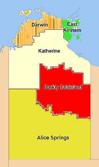
The Barkly Tableland is a rolling plain of grassland in Australia. It runs from the eastern part of the Northern Territory into western Queensland. It is one of the five regions in the Northern Territory and covers 283,648 square kilometres (109,517 sq mi), 21% of the Northern Territory. The Barkly Tableland runs parallel to the southern shore of the Gulf of Carpentaria, from about Mount Isa, Queensland to near Daly Waters.
Kalkatungu is an extinct Australian Aboriginal language formerly spoken around the area of Mount Isa and Cloncurry, Queensland.

The Shire of Cloncurry is a local government area in North West Queensland, Australia. It covers an area of 47,971 square kilometres (18,521.7 sq mi), and has existed as a local government entity since 1884. The major town and administrative centre of the shire is Cloncurry.

The Shire of Burke is a local government area in North West Queensland, Australia. The shire lies on the south coast of the Gulf of Carpentaria and abuts the border with the Northern Territory. It covers an area of 39,864 square kilometres (15,391.6 sq mi), and has existed as a local government entity since 1885. The major town and administrative centre of the shire is Burketown.
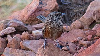
The Kalkadoon grasswren, also called the Ballara grasswren, is a species of passerine bird in the family Maluridae. It is endemic to Australia.
Ngawun is an extinct Mayi language once spoken on the Cape York Peninsula of Queensland, Australia, by the Wunumara and Ngawun peoples. The last speaker of the language was Cherry O'Keefe who died of pneumonia on 24 August 1977.

The Gulf Country is the region of woodland and savanna grassland surrounding the Gulf of Carpentaria in north western Queensland and eastern Northern Territory on the north coast of Australia. The region is also called the Gulf Savannah. It contains large reserves of zinc, lead and silver. The Gulf Country is crossed by the Savannah Way highway.

The McIlwraith Range is a rugged, dissected granite plateau on Cape York Peninsula of Far North Queensland, Australia. Part of the Great Dividing Range, the McIlwraith Range covers about 3,000 square kilometres (1,200 sq mi) and lies about 15 kilometres (9.3 mi) east of the town of Coen, and 550 kilometres (340 mi) north of Cairns. The Archer and Stewart Rivers rise in the range, with the Archer draining the range's western slopes into the Gulf of Carpentaria and the Stewart draining east into the Coral Sea. The range receives an annual rainfall of about 1,500 millimetres (59 in).
Kynuna is an outback town in the Shire of McKinlay and a locality split between the Shire of McKinlay and the Shire of Winton in Queensland, Australia. In the 2016 census the locality of Kynuna had a population of 55 people.

McKinlay is an outback town and locality in McKinlay Shire, Queensland, Australia. In the 2016 census, the locality of McKinlay had a population of 178 people.
Duchess is a rural town and locality in the Shire of Cloncurry, Queensland, Australia. In the 2016 census, Duchess had a population of 23 people.

The Cloncurry River is situated in the Gulf Country of north west Queensland, Australia.

Traeger is an electoral district of the Legislative Assembly in the Australian state of Queensland. It was created in the 2017 redistribution, and was named after Alfred Traeger, inventor of the pedal-powered radio, which was a significant contribution to people living in remote and rural communities in Queensland, such as those within Traeger.
