Sunshine Coast Light Rail

Last updated

Sunshine Coast Light Rail
Overview
StatusEarly planning stages
Locale Sunshine Coast
Termini
Service
Type Light Rail
System Translink
Services1 route (built in two stages)
Technical
Track gauge 1,435 mm (4 ft 8+12 in)
Route map

Contents

BSicon uexKINTa.svg
Maroochydore CBD
BSicon uexHST.svg
Alexandra Headland
BSicon uexHST.svg
Mooloolaba
BSicon uexHST.svg
Kawana Shoppingworld
BSicon uexHST.svg
Sunshine Coast University Hospital
BSicon uexKBHFe.svg
Caloundra

The Sunshine Coast Light Rail is a proposed light rail system for the Sunshine Coast region of Queensland, Australia. The light rail system would link Maroochydore with Caloundra via Mooloolaba and Kawana and was planned to bring a frequent, high-quality light rail service to meet the region's predicted growth. The system underwent feasibility studies in 2015. [1]

The proposal has not been welcomed by all members of the community with many people believing the project threatens the region's laidback coastal lifestyle. [2]

History

The Sunshine Coast Council reviewed and supported the findings of a pre-feasibility study. In August 2012, the council gave the go-ahead for a full feasibility study to be undertaken. In November 2014, the options were put on display with comments sought with over 700 submissions received. [3] [4] [5] After the council reviewed the outcome of the community consolation in November 2014, they have the confidence to further investigate a light rail corridor. 87% of the survey respondents were in favour of the light rail. As of 2016, the council is exploring potential funding models for the delivery of the project. It noted that the project would still require state government support. [6]

In addition, the council and the Department of Transport and Main Roads are seeking to establish a high frequency bus line that will follow the proposed light rail corridor (as a forerunner) of the light rail system.

Route Options

The proposed system will stretch approximately 20 kilometres from Maroochydore to Caloundra. A full route is still undecided with multiple proposed routes, however following the results of the feasibility study conducted in November 2014, the Sunshine Coast Council have identified a possible route alignment for the light rail. All routes pass through the key activity hubs of Maroochydore, Mooloolaba, Kawana and Caloundra, however various routes are proposed.

Following the community consultation, the council has identified a possible route alignment for the light rail. However, this is still undecided and the previous route proposals are still being looked at.

The new proposed route will follow Option A of the Maroochydore route, commencing at the Plaza Parade in the Maroochydore CBD before cutting through part of the Horton Park Golf Course, then travelling along Aerdrome Road, this route is the quickest route compared to other proposed routes and supports the Maroochydore City Centre Priority Development Area. The route continues along Aerdrome Road towards Mooloolaba. Following route B of the Mooloolaba proposed routes, the route will turn onto Veening Street, just west of the key activity area of Mooloolaba. Travelling along Walan Street, the route will then turn on to Brisbane Road, continuing south towards Kawana. Once in Kawana the light rail will follow route option A passing the Sunshine Coast University Hospital and supports the development of the Kawana Town Centre. The Caloundra corridor is still undecided. The local council will continue to investigate the three proposed routes to find the best route.

Original corridor route options

Proposed Maroochydore routes

Maroochydore Maroochydore, Queensland 2.jpg
Maroochydore

Maroochydore is the key activity centre on the Sunshine Coast.

Option A

Option A is the shortest but most direct route resulting in the fastest travel time. This option will start from the Maroochydore CBD and travel along Aerodrome Road towards Mooloolaba. This route option has a wide pedestrian catchment area and supports Maroochydore City Centre Priority Development Area and transit interchange with future heavy rail.

Option B

A slightly longer route then Option A, Option B will start from the Maroochydore CBD, traveling briefly along Aerodrome Road before going along Kingsford-Smith Parade. This route option has an improved access to the Maroochydore Surf Club and sporting grounds and reduces interference with traffic lights along Aerodrome Road.

Option C

Option C, although the longest route in the Maroochydore area provides direct access to tourist and residential accommodation and tourist destinations and provides greater access to the Sunshine Plaza, the Sunshine Coast's largest shopping centre.

Proposed Mooloolaba routes

Mooloolaba Mooloolaba, Queensland - 02.jpg
Mooloolaba

Mooloolaba is an established lifestyle and tourism destination.

Option A

Option A provides excellent access to the beach and fantastic iconic views along the Mooloolaba foreshore. This route option also provides good access to retail and dining along the Mooloolaba Esplanade.

Option B

Option B, travels along the Mooloolaba Esplanade traveling before travelling along Venning Street, just short of the main retail and dining hot spot of Mooloolaba Esplanade. Option B continues along Venning Street and Walan Street before turning on to Brisbane Road and traveling south towards Kawana.

Option C

Option C is slightly longer than Option A and B but provides access to the Mooloolaba Spit, Wharf precinct and Surf Club. This route option also provides scenic views along the river edge and could support a new river edge lifestyle precinct.

Option D

Option D is the longest option in the Mooloolaba area, traveling along the Mooloolaba Esplanade, then along River Esplanade before going along Brisbane Road towards Kawana. This route combines the elements of option A and C, providing scenic views along the Mooloolaba foreshore and river edge as well as excellent access to the beach and the retail and dining precinct along the Mooloolaba Esplanade.

Proposed Kawana routes

Kawana is one of the fastest growing regions on the Sunshine Coast. Kawana is proposed as the terminus for stage 1 of the light rail project, with stage 2 continuing from Kawana to Caloundra.

Option A

Option A would be the longest route in the Kawana area and has a number of tight turns, increasing travel time. This route would provide direct access to the Sunshine Coast University Hospital and supports the development of the Kawana Town Centre, Business Village and Bokarina Beach. This option also provides future opportunity for a fully integrated transport interchange with a heavy rail station.

Option B

Option B followings a similar route to Option A, however aiming to improve on travel time by passing the core of the Kawana Town Centre. This route option, like Option A provides access to the University Hospital and an interchange with a future heavy rail station. This route also travels through the Kawana Industrial Estate.

Option C

Option C provides access to local schools and sporting facilities and services the existing eastern residential areas of Kawana. The route travels through the Kawana Industrial Estate and supports the development of Bokarina Beach. Option C is a more direct and faster route towards Caloundra then Option's A and B.

Option D

Option D is both the cheapest and fastest route in the Kawana area, however it limits access to the key destinations of the region. Option D still provides good access to local schools and sporting grounds. This option services the existing eastern residential areas but has over one kilometer walking distance to the key destinations such as the University Hospital and the Kawana Town Centre.

Proposed Caloundra routes

Caloundra Caloundra Queensland 2.jpg
Caloundra

Caloundra is a major lifestyle and tourism destination situated at the southern end of the Sunshine Coast.

Option A

Option A will travel directly on Nicklin Way to maximize travel speed and provides excellent access to Bulcock Street and Omrah Avenue. The route supports direct access to West Terrace hospital precinct and the RSL club. This route also provides good access to potential development sites along the central areas of Caloundra and partly services the western residential areas, however it bypasses a number of coastal tourist destinations.

Option B

This option supports direct access to Moffat Bach business and industry precinct as well as direct access to sporting facilities and the Caloundra Primary School. Option B partly services the western residential area and connects commuters with Stockland Caloundra shopping centre.

Option C

Option C is the longest option in the Caloundra region but provides access with recreation and tourism destinations which the other two options lack as well as the residential areas of central Caloundra. This route provides good access to sporting facilities and the local primary school and establishes strong connectivity to the beach.

See also

Related Research Articles

<span class="mw-page-title-main">Sunshine Coast, Queensland</span> Region in Queensland, Australia

The Sunshine Coast is a peri-urban region in South East Queensland, Australia. It is the district defined in 1967 as "the area contained in the Shires of Landsborough, Maroochy and Noosa, but excluding Bribie Island". Located 100 km (62 mi) north of the centre of Brisbane in South East Queensland, on the Coral Sea coastline, its urban area spans approximately 60 km (37 mi) of coastline and hinterland from Pelican Waters to Tewantin.

<span class="mw-page-title-main">Mooloolaba</span> Suburb of Maroochydore, Queensland, Australia

Mooloolaba is a coastal suburb of Maroochydore in the Sunshine Coast Region, Queensland, Australia. It is located 97 kilometres (60 mi) north of the state capital, Brisbane, and is part of the Maroochydore urban centre. In the 2021 census, Mooloolaba had a population of 8,202 people.

<span class="mw-page-title-main">Caloundra</span> Town in Queensland, Australia

Caloundra is a coastal town and the southernmost town in the Sunshine Coast Region in South East Queensland, Australia.

The Sunshine Motorway is a thirty-three kilometre Australian motorway on the Sunshine Coast region of Queensland, just north of Brisbane. It was initially a tolled motorway before these were removed in 1996 after excessive complaints regarding the need of a toll. It is part of State Route 70, which extends north a further 12.3 kilometres to Noosaville. For completeness, and to aid in understanding of the usage of this road, the extension is included in this article.

<span class="mw-page-title-main">Sunshine Coast Airport</span> Airport in Queensland, Australia

Sunshine Coast Airport is an Australian international airport located in Marcoola, 10 km (6.2 mi) north of Maroochydore, at the northern end of the Sunshine Coast. It is approximately 90 km (56 mi) north of centre of Brisbane, within the South East Queensland agglomeration. The airport is owned by Sunshine Coast Regional Council and is the principal and only jet-capable airport serving an urban area of nearly 400,000 residents.

<span class="mw-page-title-main">Maroochydore</span> Town in Queensland, Australia

Maroochydore is a coastal city in the Sunshine Coast Region, Queensland, Australia.

<span class="mw-page-title-main">Landsborough railway station</span> Train station in Queensland, Australia

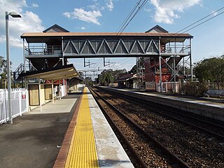
Landsborough railway station is located on the North Coast line in Queensland, Australia. It serves the town of Landsborough in the Sunshine Coast Region.

<span class="mw-page-title-main">Caloundra bus station</span>

Caloundra bus station was opened on 16 April 1992 by Minister for Transport David Hamill. It is serviced by six Kinetic Group routes. It is in Zone 5 of the Translink integrated public transport system.

<span class="mw-page-title-main">Shire of Maroochy</span> Local government area in Queensland, Australia

The Shire of Maroochy was a local government area about 100 kilometres (62 mi) north of Brisbane in the Sunshine Coast region of South East Queensland, Australia. The shire covered an area of 1,162.7 square kilometres (448.9 sq mi), and existed as a local government entity from 1890 until 2008, when it amalgamated with its neighbours to the north and south to form the Sunshine Coast Region.

<span class="mw-page-title-main">Maroochydore railway line</span>

The Maroochydore railway line, or CAMCOS, is a proposed railway line on the Sunshine Coast, Queensland, Australia.

Nicklin Way (SR6) is a major road in Sunshine Coast, Queensland, Australia. It is named after former Queensland Premier Frank Nicklin, who opened the road on 5 June 1965. It runs from the southern end of the Sunshine Motorway at Mooloolaba in the north to Caloundra in the south, with the route signed as State Route 6. With the population of Sunshine Coast growing quickly, the road is often prone to congestion.

<span class="mw-page-title-main">Kawana Waters, Queensland</span> Town in Queensland, Australia

Kawana Waters is an urban centre on the Sunshine Coast in Queensland, Australia, between Caloundra and Maroochydore along the Coral Sea coast. It was originally the estate development name and has passed into common usage, but it is not officially a town nor a locality. The official suburbs are connected by the Nicklin Way arterial road. It is sometimes abbreviated to Kawana, which is a suburb of Rockhampton.

<span class="mw-page-title-main">Transport on the Gold Coast, Queensland</span>

The Gold Coast is the largest regional city and fastest growing city in Australia. As a result, the Gold Coast has a wide range of public and private transport options from cars and bikes to buses, heavy rail and light rail. The car is the dominant mode of transport in the city with an extensive arterial road network that connects the standard residential streets with major suburbs and motorways.

<span class="mw-page-title-main">Sunshine Coast Region</span> Local government area in Queensland, Australia

The Sunshine Coast Region is a local government area located in the Sunshine Coast region of South East Queensland, Australia.

Kawana Shoppingworld is a regional shopping centre located in Buddina, Queensland, Australia, that is operated by Mirvac. Anchor tenants include Coles Supermarkets, Aldi, Woolworths Supermarkets, Big W, and JB Hi-Fi.

<span class="mw-page-title-main">Rail network in South East Queensland</span>

Queensland Rail operates ten suburban lines and three interurban lines. Centering in the Brisbane City, it extends as far as Gympie in the north, Varsity Lakes in the south, Rosewood in the west, and Cleveland in the east to Moreton Bay.

<span class="mw-page-title-main">Cotton Tree Caravan Park</span> Historic site in Queensland, Australia

Cotton Tree Caravan Park is a heritage-listed caravan park at Cotton Tree Parade, Cotton Tree, Sunshine Coast Region, Queensland, Australia. It was added to the Queensland Heritage Register on 3 April 2009.

Maroochydore Road is a major arterial road on the Sunshine Coast, Queensland that connects the major town/urban centre of Maroochydore with the Bruce Highway.

Caloundra Road is a continuous 9.3-kilometre (5.8 mi) road route in the Sunshine Coast local government area of Queensland, Australia. Most of it is designated as part of State Route 6. It is a state-controlled district road, part of which is rated as a local road of regional significance (LRRS).

References

  1. "Sunshine Coast Light Rail". Sunshine Coast Light Rail. Sunshine Coast Council. Archived from the original on 1 March 2015. Retrieved 9 March 2015.
  2. Sheehan, Amy (19 February 2021). "Sunshine Coast locals fight back against light rail, mass transit fearing 'destruction of their lifestyle". ABC News . Australian Broadcasting Corporation . Retrieved 29 July 2023.
  3. Light rail route options on public display Archived 1 March 2015 at the Wayback Machine Sunshine Coast Council 3 November 2014
  4. Sunshine Coast Council release route options for proposed light rail Archived 24 December 2014 at the Wayback Machine Brisbane Times 5 November 2014
  5. More than 700 have say on Coast's light rail plan Archived 2 April 2015 at the Wayback Machine Sunshine Coast Daily 17 December 2014
  6. Templeton, Anthony (13 June 2016). "Sunshine Coast light rail could be built well within a decade through private investment funding". The Courier-Mail.