Sunshine Coast railway line

Last updated

Sunshine Coast line
Landsborough Railway Station, Queensland, Sep 2012.JPG
Overview
StatusOperational
Owner Queensland Rail
Locale Sunshine Coast
Termini
Stations29
Website queenslandrail.com.au
Service
TypeCommuter rail/Intercity rail
System Queensland Rail Citytrain network
Operator(s)Queensland Rail
Rolling stock IMU (Gympie North & Nambour)
SMU260/NGR (Nambour)
Technical
Line length180 km (110 mi)
Track length172.21 km (107.01 mi)
Number of tracksQuadruple to Northgate, triple to Petrie, double to Beerburrum, remainder single track with passing loops.
Track gauge 1,067 mm (3 ft 6 in)
Electrification 1988
Operating speed140 km/h (87 mph)

The Sunshine Coast railway line refers to the section of Queensland's North Coast line that has regular interurban passenger services, which connect Brisbane with the Sunshine Coast and as far north as Gympie. It is the longest line on the Queensland Rail Citytrain network.

Contents

Overview

Elimbah station in September 2012 Elimbah Railway Station, Queensland, Sep 2012.JPG
Elimbah station in September 2012
Glasshouse Mountains station in September 2012 Glasshouse Mountains Railway Station, Queensland, Sep 2012.JPG
Glasshouse Mountains station in September 2012

Nambour and Gympie North services use the Caboolture line to Caboolture, then the North Coast line to Nambour and Gympie North. The line consists of four tracks from Roma Street to Northgate, then three tracks to Petrie, allowing Nambour & Gympie North express services to pass the local Caboolture services. The line is then double track to Beerburrum.

North of Beerburrum, the line is single track with passing loops at most stations. Due to the rapidly rising population on the Sunshine Coast and in hinterland towns, the annual compounded growth rate for morning peak passenger numbers on the line north of Caboolture is 6%, second only to the 7.1% figure for the Gold Coast line south of Beenleigh.

Traveltrain services; the Spirit of Queensland , [1] Spirit of the Outback [2] and the Bundaberg and Rockhamption Tilt Trains [3] traverse the line, along with Aurizon and Pacific National freight trains.

History

The North Coast railway line reached the Sunshine Coast area in 1890. In 1988, the section of the line was electrified for electric multiple units. Today, the Sunshine Coast railway line uses interurban passenger services operated by Citytrain.

Upgrades

In 2001, the Queensland Government started a study for the need to upgrade the North Coast Line between Caboolture and Landsborough.

On 14 April 2009, a new 14-kilometre (8.7 mi) double-track alignment from Caboolture to Beerburrum opened. A four kilometre section of the old line immediately north of Caboolture was retained for use as a passing loop, with the remainder of the old line lifted. This saw new stations at Elimbah and Beerburrum built. Glasshouse Mountains, Beerwah and Landsborough stations have all received major work including platform extensions and lifts. [4] [5] The line is scheduled to be duplicated to Landsborough by 2021. [6]

In 2009, the platforms at Mooloolah, Palmwoods, Woombye, Eudlo, Eumundi, Pomona and Cooran were extended with scaffolding and plywood materials. [7] Initially intended as an interim arrangement until permanent extensions were built, the temporary platforms remain. [8]

A study has been completed into duplicating and straightening the line between Landsbrough and Nambour. It is proposed that two new tunnels and four upgraded stations (Mooloolah, Eudlo, Palmwoods and Woombye) will be constructed. [9]

Line guide and services

Trains to and from Nambour typically run express between Petrie and Bowen Hills, with stops at Northgate and Eagle Junction. [10] Trains to and from Gympie North skips stations between Caboolture and Bowen Hills stopping only at Petrie and Northgate.

To relieve congestion on the section north of Beerburrum, the rail service is supplemented by a bus service operated by Kangaroo Bus Lines on weekdays between Caboolture and Nambour as route 649. [10] Passengers for/from the Redcliffe Peninsula line change at Petrie, Shorncliffe line at Northgate, Airport and Doomben lines change at Eagle Junction and Ferny Grove lines change at Bowen Hills, and all other lines at Central.

Sunshine Coast railway line
showing distance from Central and ticket zone
km
BSicon CONTg.svg
BSicon STR+l.svg
BSicon ABZgr+r.svg
BSicon STR.svg
BSicon ACC.svg
172.2 km
Gympie North
(8)
BSicon STR.svg
BSicon SKRZ-G2o.svg
Australian state route 15.svg
Tin Can Bay Rd
BSicon HST.svg
BSicon STR.svg
Gympie
BSicon vSHI2l-.svg
BSicon dSTR.svg
BSicon vUSTxl.svg
BSicon dCONTgq.svg
BSicon dSTRr+1h.svg
BSicon STR.svg
BSicon BS2c4.svg
Mary Valley Rattler to Amamoor
BSicon SKRZ-Bu.svg
AUS Alphanumeric Route M1.svg
Bruce Highway (under construction)
BSicon HST.svg
150.3 km
Traveston
(8)
BSicon HSTACC.svg
145.5 km
Cooran
(8)
BSicon HSTACC.svg
139.9 km
Pomona
(8)
BSicon HSTACC.svg
130.9 km
Cooroy
(8)
BSicon SKRZ-G2u.svg
Australian state route 6.svg
Tewantin Road
BSicon SKRZ-G2o.svg
Australian state route 12.svg
Eumundi Noosa Road
BSicon HSTACC.svg
122.5 km
Eumundi
(7)
BSicon SKRZ-Bu.svg
AUS Alphanumeric Route M1.svg
BSicon HST.svg
112.7 km
Yandina
(7)
BSicon eHST.svg
110.1 km
Kulangoor
(closed)
BSicon WBRUCKE1.svg
BSicon dXPLTaq.svg
BSicon dACC.svg
BSicon uv-KSTRa.svg
BSicon dXPLTq.svg
BSicon ldACC.svg
BSicon dXPLTeq.svg
104.8 km
Nambour
(Railbus 649 Terminus) (6)
BSicon dHSTACC.svg
BSicon uHSTACC.svg
100.7 km
Woombye
(6)
BSicon uSTR+l.svg
BSicon mdKRZo.svg
BSicon uABZr+r.svg
BSicon uKHSTACCe.svg
BSicon dHSTACC.svg
BSicon uSTR.svg
97.3 km
Palmwoods
(6)
BSicon dHSTACC.svg
BSicon uHSTACC.svg
92.7 km
Eudlo
(5)
BSicon uSTR+l.svg
BSicon mdKRZu.svg
BSicon uSTRr.svg
BSicon uSTRl.svg
BSicon mdKRZu.svg
BSicon uSTR+r.svg
BSicon dTUNNEL2.svg
BSicon uSTR.svg
BSicon uSTR+l.svg
BSicon mdKRZo.svg
BSicon uSTRr.svg
BSicon uSTRl.svg
BSicon mdKRZ.svg
BSicon uSTR+r.svg
BSicon dHSTACC.svg
BSicon uHSTACC.svg
87.5 km
Mooloolah
(5)
BSicon dTUNNEL2.svg
BSicon uSTR.svg
Dularcha National Park
BSicon uKHSTACCa.svg
BSicon dHSTACC.svg
BSicon uSTR.svg
82.5 km
Landsborough
(5)
BSicon uSTRl.svg
BSicon mdKRZ.svg
BSicon uABZr+r.svg
Australian Tourist Drive 23.svg
Maleny Street
BSicon dSTR.svg
BSicon uHSTACC.svg
Australia Zoo
(5)
BSicon eABZg+l.svg
BSicon uemdKRZu.svg
BSicon exdCONTfq.svg
Maroochydore line (proposed)
BSicon dHSTACC.svg
BSicon uHSTACC.svg
76.9 km
Beerwah
(5)
BSicon dSKRZ-G2u.svg
BSicon uSTR.svg
Australian state route 6.svg
Kilcoy Beerwah Road
BSicon dHSTACC.svg
BSicon uHSTACC.svg
71.8 km
Glasshouse Mountains
(4)
BSicon uSTR+l.svg
BSicon mdKRZu.svg
BSicon uSTRr.svg
Australian state route 60.svg
Beerburrum Road
BSicon uHSTACC.svg
BSicon dHSTACC.svg
64.6 km
Beerburrum
(4)
BSicon uHSTACC.svg
BSicon dHSTACC.svg
58.6 km
Elimbah
(4)
BSicon uSKRZ-G2u.svg
BSicon dSKRZ-G2u.svg
Australian state route 85.svg
D'Aguilar Hwy
BSicon exdCONTgq.svg
BSicon uemdKRZ.svg
BSicon eABZg+r.svg
Kilcoy line (closed)
BSicon dXPLTaq.svg
BSicon uvKSTRe-.svg
BSicon ldACC.svg
BSicon dXPLTq.svg
BSicon dACC.svg
49.6 km
Caboolture
(Railbus 649 Terminus) (3)
BSicon hKRZWae.svg
Caboolture River
BSicon HSTACC.svg
46.4 km
Morayfield
(3)
BSicon SKRZ-G4u.svg
Australian state route 60.svg
Morayfield Road
BSicon HSTACC.svg
40.4 km
Burpengary
(3)
BSicon HSTACC.svg
35.6 km
Narangba
(3)
BSicon HSTACC.svg
32.1 km
Dakabin
(3)
BSicon SKRZ-G4u.svg
Australian state route 71.svg
Anzac Ave
BSicon ABZg+l.svg
BSicon cSTRq.svg
BSicon dCONTfq.svg
BSicon ACC.svg
27.4 km
Petrie
(3)
BSicon SKRZ-G4u.svg
Australian state route 58.svg
Gympie Road
BSicon LSTR.svg
Express Stops
BSicon pHST.svg
25.8 km
Lawnton
(2/3)
BSicon pHST.svg
23.8 km
Bray Park
(2)
BSicon pHST.svg
22.4 km
Strathpine
(2)
BSicon SKRZ-G2BUE.svg
Australian state route 28.svg
South Pine Road
BSicon pHST.svg
20.0 km
Bald Hills
(2)
BSicon SKRZ-Bu.svg
AUS Alphanumeric Route M3.svg
Gympie Arterial Road
BSicon SKRZ-G4u.svg
Australian state route 40.svg
Linkfield Road
BSicon pHST.svg
16.6 km
Carseldine
(2)
BSicon pHST.svg
14.9 km
Zillmere
(2)
BSicon SKRZ-G4u.svg
Australian state route 27.svg
Murphy Road
BSicon SKRZ-G4u.svg
Australian state route 28.svg
Robinson Road West
BSicon pHST.svg
13.4 km
Geebung
(2)
BSicon pHST.svg
12.4 km
Sunshine
(2)
BSicon pHST.svg
11.2 km
Virginia
(2)
BSicon SKRZ-G4u.svg
Australian state route 26.svg
Sandgate Road
BSicon ABZg+l.svg
BSicon cSTRq.svg
BSicon dCONTfq.svg
Shorncliffe line
BSicon ACC.svg
9.9 km
Northgate
(1/2)
BSicon LSTR.svg
Express Stops
BSicon pHST.svg
8.7 km
Nundah
(1)
BSicon SKRZ-G4u.svg
Australian state route 26.svg
Sandgate Road
BSicon pHST.svg
7.8 km
Toombul
(1)
BSicon ABZg+l.svg
BSicon cSTRq.svg
BSicon dCONTfq.svg
Airport line
BSicon SKRZ-G2u.svg
Australian state route 20.svg
Junction Road
BSicon ABZg+l.svg
BSicon cSTRq.svg
BSicon dCONTfq.svg
BSicon ACC.svg
6.5 km
Eagle Junction
(1)
BSicon LSTR.svg
Express Stops
BSicon pHST.svg
5.6 km
Wooloowin
(1)
BSicon pHST.svg
4.5 km
Albion
(1)
BSicon dCONTgq.svg
BSicon cSTRq.svg
BSicon ABZg+r.svg
BSicon CONTf+l.svg
BSicon ABZgxr+r.svg
BSicon ACC.svg
2.7 km
Bowen Hills
(1)
BSicon tACCa@f.svg
1.3 km
Fortitude Valley
(1)
BSicon tACC.svg
0.0 km
Central
(1)
BSicon tACCe@g.svg
0.8 km
Roma Street
(1)
BSicon CONTg+l.svg
BSicon ABZgr+r.svg
BSicon CONTf.svg

Related Research Articles

<span class="mw-page-title-main">Bruce Highway</span> Highway in Queensland, Australia

The Bruce Highway is a major highway in Queensland, Australia. Commencing in the state capital, Brisbane, it passes through areas close to the eastern coast on its way to Cairns in Far North Queensland. The route is part of the Australian National Highway and also part of Highway 1, the longest highway route in Australia. Its length is approximately 1,679 kilometres (1,043 mi); it is entirely sealed with bitumen. The highway is named after a popular former Queensland and federal politician, Harry Bruce. Bruce was the state Minister for Works in the mid-1930s when the highway was named after him. The highway once passed through Brisbane, but was truncated at Bald Hills when the Gateway Motorway became National Highway 1 upon its opening in December 1986.

<span class="mw-page-title-main">Shorncliffe railway line</span> Suburban railway line in Queensland, Australia

The Shorncliffe railway line is an 11 kilometres (6.8 mi) suburban railway line situated north of Brisbane, the state capital of Queensland, Australia. It is part of the Queensland Rail Citytrain network.

<span class="mw-page-title-main">Caboolture railway line</span> Suburban railway service in Brisbane, Australia

The Caboolture railway line refers to the section of Queensland's North Coast Line that has a regular suburban railway service, extending north of Brisbane, the state capital of Queensland, Australia. The line commences at Roma Street railway station, travelling through the city and extends through Brisbane's northern suburbs to Caboolture, which the line continues north to Sunshine Coast and connects with the Ipswich line south-west of Brisbane. The line distance from Brisbane Central railway station is 49.6 km (30.8 mi).

<span class="mw-page-title-main">Caboolture railway station</span> Railway station in Queensland, Australia

Caboolture railway station is located on the North Coast line in Queensland, Australia. It serves the urban centre of Caboolture in the City of Moreton Bay.

<span class="mw-page-title-main">Landsborough railway station</span> Train station in Queensland, Australia

Landsborough railway station is located on the North Coast line in Queensland, Australia. It serves the town of Landsborough in the Sunshine Coast Region.

<span class="mw-page-title-main">Beerwah railway station</span> Railway station in Queensland, Australia

Beerwah railway station is a heritage-listed railway station on the North Coast line in Queensland, Australia. It serves the town of Beerwah in the Sunshine Coast Region. It is listed on the Sunshine Coast Region Heritage Register.

<span class="mw-page-title-main">Glasshouse Mountains railway station</span> Railway station in Queensland, Australia

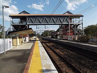
Glasshouse Mountains railway station is located on the North Coast line in Queensland, Australia. It serves the town of Glass House Mountains in the Sunshine Coast Region.

<span class="mw-page-title-main">Beerburrum railway station</span> Railway station in Queensland, Australia

Beerburrum railway station is located on the North Coast line in Queensland, Australia. It serves the town of Beerburrum in the Sunshine Coast Region.

<span class="mw-page-title-main">Elimbah railway station</span> Railway station in Queensland, Australia

Elimbah railway station is located on the North Coast line in Queensland, Australia. It serves the town of Elimbah in the City of Moreton Bay.

<span class="mw-page-title-main">North Coast railway line, Queensland</span> Railway line in Queensland, Australia

The North Coast railway line (NCL) is a 1,681-kilometre (1,045 mi) 1067 mm gauge railway line in Queensland, Australia. It commences at Roma Street station, Brisbane, and largely parallels the Queensland coast to Cairns in Far North Queensland. The line is electrified between Brisbane and Rockhampton. Along the way, the 1680 km railway passes through the numerous towns and cities of eastern Queensland including Nambour, Bundaberg, Gladstone, Rockhampton, Mackay and Townsville. The line though the centre of Rockhampton runs down the middle of Denison Street.

<span class="mw-page-title-main">Mooloolah railway station</span> Railway station in Queensland, Australia

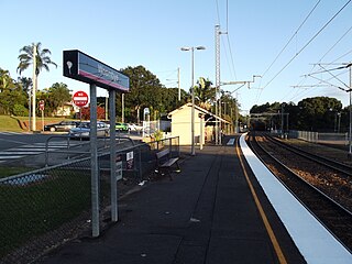
Mooloolah railway station is located on the North Coast line in Queensland, Australia. It serves the town of Mooloolah Valley in the Sunshine Coast Region.

<span class="mw-page-title-main">Eudlo railway station</span> Railway station in Queensland, Australia

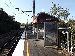
Eudlo railway station is located on the North Coast line in Queensland, Australia. It serves the town of Eudlo in the Sunshine Coast Region. It is one of few stations that can only fit 4 carriages onto the platform.

<span class="mw-page-title-main">Palmwoods railway station</span> Railway station in Queensland, Australia

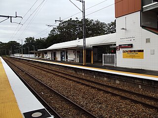
Palmwoods railway station is located on the North Coast line in Queensland, Australia. It serves the town of Palmwoods in the Sunshine Coast Region.

<span class="mw-page-title-main">Woombye railway station</span> Australian train station

Woombye railway station is located on the North Coast line in Queensland, Australia. It serves the town of Woombye in the Sunshine Coast Region.

<span class="mw-page-title-main">Nambour railway station</span> Railway station in Queensland, Australia

Nambour railway station is located on the North Coast line in Queensland, Australia. It serves the town of Nambour in the Sunshine Coast Region.

<span class="mw-page-title-main">Maroochydore railway line</span>

The Maroochydore railway line, also known as the Direct Sunshine Coast Rail Line or CAMCOS, is a proposed railway line on the Sunshine Coast, Queensland, Australia.

<span class="mw-page-title-main">Sunshine Coast Region</span> Local government area in Queensland, Australia

The Sunshine Coast Region is a local government area located in the Sunshine Coast region of South East Queensland, Australia.

<span class="mw-page-title-main">Railways in South East Queensland</span>

South East Queensland has a large passenger and freight railway network centred on Brisbane, the capital city of the Australian state of Queensland. Suburban and interurban passenger services in the region are operated by Queensland Rail, which also operates long-distance trains across the state. Aurizon and Pacific National operate freight services.

North Coast Line (NCL) opening dates chronologically

References

  1. "Spirit of Queensland timetable" (PDF). Queensland Rail Travel. 13 June 2020.
  2. "Spirit of the Outback timetable" (PDF). Queensland Rail Travel. 23 June 2020.
  3. "Tilt Train timetable" (PDF). Queensland Rail Travel. 13 June 2020.
  4. Landsborough station upgrade plans revealed Archived 5 February 2012 at the Wayback Machine Queensland Government 21 December 2006
  5. Caboolture to Beerburrum Duplication Queensland Rail
  6. Caboolture to Landsborough Rail Upgrade Study Archived 23 December 2014 at the Wayback Machine Department of Transport & Main Roads
  7. Works commence on North Coast platform extensions Queensland Rail 10 August 2009
  8. Travellers blast lack of funding Archived 24 December 2014 at the Wayback Machine Sunshine Coast Daily 2 February 2012
  9. "Landsborough to Nambour Rail Corridor Study". Queensland Government. 2009. Archived from the original on 9 November 2007. Retrieved 2 May 2009.
  10. 1 2 "Sunshine Coast Line timetable". Translink . 2 March 2020.