Rathdowney, Queensland

Last updated

Map all coordinates using: OpenStreetMap  
Rathdowney
Queensland
Rathdowney.JPG
Rathdowney seen from the town's scenic lookout
Australia Queensland location map.svg
Red pog.svg
Rathdowney
Coordinates 28°12′41″S152°51′48″E / 28.2114°S 152.8633°E / -28.2114; 152.8633 (Rathdowney (town centre))
Population308 (2016 census) [1]
 • Density4.266/km2 (11.049/sq mi)
Postcode(s) 4287
Area72.2 km2 (27.9 sq mi)
Time zone AEST (UTC+10:00)
LGA(s) Scenic Rim Region
State electorate(s) Scenic Rim
Federal division(s) Wright
Localities around Rathdowney:
Maroon Knapp Creek Tamrookum Creek
Maroon Rathdowney Innisplain
Barney View Palen Creek Running Creek

Rathdowney (historically also written as Rathdownie) is a rural town and locality in the Scenic Rim Region, Queensland, Australia. [2] [3] In the 2016 census, Rathdowney had a population of 308 people. [1]

Geography

Rathdowney is on the Mount Lindesay Highway 32 kilometres (20 mi) south of Beaudesert at the base of the McPherson Range.[ citation needed ]

The eastern boundary is marked by the Logan River. It is also close to some of the areas of greatest biodiversity in Australia, and a gateway to various National Parks such as Border Ranges National Park and Mount Barney National Park with a variety of lush rainforest, eucalypt forest, mountain heath and other habitats.[ citation needed ]

The former locality of Bigriggan (also spelled Bigriggen) is within Rathdowney, 8 kilometres (5.0 mi) west of the town ( 28°11′55″S152°46′48″E / 28.1986°S 152.7799°E / -28.1986; 152.7799 (Bigriggan) ). It is accessed via Bigriggan Road which terminates at the Bigriggan Reserve Park, located near the confluence of Burnett Creek and the Logan River. The park provides camp sites with a kiosk by the river with access available to caravans, motorhomes and buses. [4] [5]

History

Mununjali (also known as Mananjahli, Manaldjahli and Manandjali) is a dialect of the Yugambeh language. The Mununjali language area includes landscape within the local government boundaries of the Scenic Rim and Beaudesert Shire Councils. [6]

The first European exploration of the area was by Patrick Logan, commandant of the Moreton Bay penal colony, in 1828. The area became available for settlement in 1842. Thomas Lodge Murray-Prior purchased a large freehold estate in 1876, which he named Rathdowney Station after the Murray-Prior estates in Rathdowney, Ireland. [7]

The town was named after the former Rathdowney pastoral station. [2] [8]

Timber clearing was the first major industry in the area. Cattle grazing and dairy farming are now the main industries.[ citation needed ]

Bigriggan Provisional School opened in November 1892. There were a number of temporary closures due to low student numbers before it closed in 1906. It re-opened in 1910 as Bigriggan State School but closed permanently on 25 April 1912. [9]

Rathdownie Provisional School opened on 10 February 1908. On 1 January 1909 it became Rathdownie State School. In 1914 the name was changed to Cashell's Hill State School. It closed in 1924. [9]

Plaque commemorating Enright's General Store, 2006 Plaque commemorating Enright's General Store, Rathdowney, 2006.jpg
Plaque commemorating Enright's General Store, 2006

Enright's General Store opened in 1909. It operated until 1971. It is commemorated by a plaque. [10]

Beaudesert Shire Tramway train at Rathdowney in 1912 StateLibQld 1 111364 Train on the Beaudesert tramway halted at Rathdowney Station, 1912.jpg
Beaudesert Shire Tramway train at Rathdowney in 1912

The Beaudesert Shire Tramway was extended to Rathdowney in 1911, but closed in 1944. [11]

Rathdowney Terminus State School opened on 14 May 1912; the school's name presumably refers to the terminus of the tramway. In 1915 it was renamed Rathdowney State School. [9]

In April 1928, 116 subdivided allotments of "Telemon Estate, Beaudesert" were auctioned by Isles, Love & Co. and in conjunction with M. Selwyn Smith & Son Auctioneers. 25 dairy and agricultural farms, 72 township allotments and 19 farmlets from the estate of Chris J. Collins were available. According to the map advertising the auction, the estate was 17 miles from Beaudesert and 64 miles from Brisbane. [12] [13]

The foundations for St David's Anglican Church were laid on Saturday 9 March 1929. [14] The church was opened and dedicated on Saturday 13 July 1929 by Bishop Henry Le Fanu. [15] [16]

St Joseph's Catholic Church, 1929 St. Joseph's Catholic Church, Rathdowney, 1929 (4970128792).jpg
St Joseph's Catholic Church, 1929

St Joseph's Catholic Church was opened on 29 September 1929 by Archbishop James Duhig. [17] Prior to this, Catholic services were held in the Rathdowney Memorial Hall and the Rathdowney School of Arts. [18]

Rathdowney Uniting (formerly Methodist) Church, 2006 Rathdowney Uniting (formerly Methodist) Church, 39 Running Creek Road, 2006 02.jpg
Rathdowney Uniting (formerly Methodist) Church, 2006

In 1957, Palen Creek Methodist Church was relocated to 39 Running Creek Road ( 28°12′40″S152°52′05″E / 28.2111°S 152.8680°E / -28.2111; 152.8680 (Rathdowney Uniting (formerly Methodist) Church) ) in Rathdowney. In the 1970s, it was further extended with the Glenapp hall and the Barney View Lutheran Church. When the Methodist Church became part of the Uniting Church in Australia in 1977, it became the Palen Creek Uniting Church. It held its last service on Sunday 23 February 2014. [19] [20] It is now in private ownership. [21]

In the 2011 census, Rathdowney had a population of 434. [22]

In the 2016 census, Rathdowney had a population of 308 people. [1]

Heritage listings

Rathdowney has the following heritage-listed sites:

Education

Rathdowney State School is a government primary (Prep-6) school for boys and girls at Mount Lindesay Highway ( 28°12′56″S152°51′38″E / 28.2156°S 152.8605°E / -28.2156; 152.8605 (Rathdowney State School) ). [24] [25] In 2017, the school had an enrolment of 39 students with 7 teachers (3 full-time equivalent) and 5 non-teaching staff (3 full-time equivalent). [26] The school has a 25-metre (82 ft) swimming pool in which every spring and summer the swimming club has races on a Friday night. The swimming club also has swimming training during the week after school.[ citation needed ]

Amenities

St David's Anglican Church, 2006 St David's Anglican Church, 8-12 Hardgrave Street, Rathdowney, 2006 01.jpg
St David's Anglican Church, 2006

Currently the small town has a police station, a small shop, a pub, a service station, a post office, memorial grounds, information centre, and a bowls club.

The Scenic Rim Regional Council operates a mobile library service which visits Collins Street. [27]

St David's Anglican Church is at 8-12 Hardgrave Street ( 28°12′37″S152°51′45″E / 28.2103°S 152.8626°E / -28.2103; 152.8626 (St David's Anglican Church) ). [23]

St Joseph's Catholic Church is at 157-159 Mount Lindesay Highway ( 28°12′59″S152°51′33″E / 28.2164°S 152.8592°E / -28.2164; 152.8592 (St Joseph's Catholic Church) ). [23]

Attractions

There are many tours, farm stays, guest houses and other opportunities available for visitors to experience this region, which is about a 90-minute drive from Brisbane or the Gold Coast. In Autumn every year the population rises by several thousand for one day at the Rathdowney Heritage Festival, organised by the Rathdowney and District Historical Association (RADHA).[ citation needed ]

The RADHA also operate the Rathdowney Information Centre and Historical Museum at 82 Mount Lindesay Highway ( 28°12′43″S152°51′48″E / 28.2120°S 152.8634°E / -28.2120; 152.8634 (Rathdowney Information Centre and Historical Museum) ). The centre presents information on natural heritage, indigenous heritage and history of white settlement from the time of the first pioneers to present day. The Glenapp railway siding was relocated to the museum. [28]

See also

Related Research Articles

<span class="mw-page-title-main">Beaudesert, Queensland</span> Town in Queensland, Australia

Beaudesert is a rural town and locality in the Scenic Rim Region, Queensland, Australia. In the 2016 census, Beaudesert had a population of 6,395 people.

<span class="mw-page-title-main">Logan River</span> River in Queensland, Australia

The Logan River is a perennial river in the Scenic Rim, Logan and Gold Coast local government areas of the South East region of Queensland, Australia. The 184-kilometre (114 mi)-long river is one of the dominant waterways in South East Queensland that drains the southern ranges of the Scenic Rim and empties into Moreton Bay after navigating the City of Logan, a major suburban centre located south of Brisbane. The catchment is dominated by urban and agricultural land use. Near the river mouth are mangrove forests and a number of aquaculture farms.

<span class="mw-page-title-main">Boonah, Queensland</span> Town in Queensland, Australia

Boonah is a rural town and locality in the Scenic Rim Region, Queensland, Australia. In the 2016 census, the locality of Boonah had a population of 2,484 people.

<span class="mw-page-title-main">Mount Lindesay (Queensland)</span> Suburb of Scenic Rim Region, Queensland, Australia

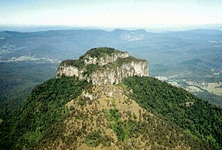
Mount Lindesay is a rural locality in the Scenic Rim Region, Queensland, Australia. It borders New South Wales. In the 2016 census, Mount Lindesay had a population of 3 people.

<span class="mw-page-title-main">Canungra, Queensland</span> Town in Queensland, Australia

Canungra is a rural town and locality in the Scenic Rim Region, Queensland, Australia. In the 2016 census, the locality of Canungra had a population of 1,229 people.

<span class="mw-page-title-main">Dugandan, Queensland</span> Suburb of Boonah, Queensland, Australia

Dugandan is a rural town and locality in the Scenic Rim Region, Queensland, Australia. In the 2016 census, Dugandan had a population of 593 people.

<span class="mw-page-title-main">Beaudesert Shire Tramway</span> Former tramway in Queensland, Australia

The Beaudesert Shire Tramway was a narrow gauge tramway which operated from Beaudesert to Lamington and Rathdowney in the Scenic Rim Region, Queensland, Australia, It was one of 15 light railways built and operated by Divisional Boards and Shire Councils in Queensland. The line carried passengers and cargo. It operated from 1903 to 1944. It was initially profitable and seen as a great success for the local shire council. The tramway is credited with opening up the agricultural lands of the upper Logan River.

<span class="mw-page-title-main">Maroon, Queensland</span> Suburb of Scenic Rim Region, Queensland, Australia

Maroon is a rural locality in the Scenic Rim Region, Queensland, Australia. In the 2016 census, Maroon had a population of 149 people.

<span class="mw-page-title-main">Tamrookum, Queensland</span> Suburb of Scenic Rim Region, Queensland, Australia

Tamrookum is a rural locality in the Scenic Rim Region, Queensland, Australia. In the 2016 census, Tamrookum had a population of 91 people.

<span class="mw-page-title-main">Barney View, Queensland</span> Suburb of Scenic Rim Region, Queensland, Australia

Barney View is a rural locality in the Scenic Rim Region, Queensland, Australia. In the 2016 census, Barney View had a population of 64 people.

<span class="mw-page-title-main">Veresdale, Queensland</span> Suburb of Logan City, Queensland, Australia

Veresdale is a locality split between the City of Logan and the Scenic Rim Region, Queensland, Australia. In the 2016 census, Veresdale had a population of 392 people.

<span class="mw-page-title-main">Laravale, Queensland</span> Town in Queensland, Australia

Laravale is a rural locality in the Scenic Rim Region, Queensland, Australia. In the 2016 census, Laravale had a population of 189 people.

<span class="mw-page-title-main">Josephville, Queensland</span> Town in Queensland, Australia

Josephville is a rural locality in the Scenic Rim Region, Queensland, Australia. In the 2016 census, Josephville had a population of 166 people.

<span class="mw-page-title-main">Palen Creek, Queensland</span> Suburb of Scenic Rim Region, Queensland, Australia

Palen Creek is a rural locality in the Scenic Rim Region, Queensland, Australia. It borders New South Wales. In the 2016 census, Palen Creek had a population of 280 people.

<span class="mw-page-title-main">Innisplain, Queensland</span> Suburb of Scenic Rim Region, Queensland, Australia

Innisplain is a rural locality in the Scenic Rim Region, Queensland, Australia. In the 2016 census, Innisplain had a population of 85 people.

<span class="mw-page-title-main">Oaky Creek, Queensland</span> Suburb of Scenic Rim Region, Queensland, Australia

Oaky Creek is a rural locality in the Scenic Rim Region, Queensland, Australia. In the 2016 census Oaky Creek had a population of 83 people.

<span class="mw-page-title-main">Running Creek, Queensland</span> Suburb of Scenic Rim Region, Queensland, Australia

Running Creek is a rural locality in the Scenic Rim Region, Queensland, Australia. In the 2016 census, Running Creek had a population of 147 people. It borders New South Wales.

<span class="mw-page-title-main">Gleneagle, Queensland</span> Suburb of Scenic Rim Region, Queensland, Australia

Gleneagle is a rural locality in the Scenic Rim Region, Queensland, Australia. In the 2016 census, Gleneagle had a population of 1,877 people.

Cannon Creek is a rural locality in the Scenic Rim Region, Queensland, Australia. In the 2016 census, Cannon Creek had a population of 78 people.

Ipswich–Boonah–Rathdowney Road is a continuous 87.8 kilometres (54.6 mi) road route in the Ipswich and Scenic Rim regions of Queensland, Australia. It has two official names, Ipswich–Boonah Road and Boonah–Rathdowney Road. The entire route is signed as State Route 93, and much of it is also part of Tourist Drive 16.

References

  1. 1 2 3 Australian Bureau of Statistics (27 June 2017). "Rathdowney (SSC)". 2016 Census QuickStats. Retrieved 20 October 2018. OOjs UI icon edit-ltr-progressive.svg
  2. 1 2 "Rathdowney – town in Scenic Rim Region (entry 28044)". Queensland Place Names. Queensland Government . Retrieved 17 November 2019.
  3. "Rathdowney – locality in Scenic Rim Region (entry 45182)". Queensland Place Names. Queensland Government . Retrieved 17 November 2019.
  4. "Welcome To Bigriggen Park in the Scenic Rim". Archived from the original on 26 March 2016. Retrieved 28 March 2016.
  5. "Bigriggen Park". Visit Scenic Rim. Archived from the original on 2 April 2020. Retrieved 29 April 2020.
  6. CC BY icon-80x15.png This Wikipedia article incorporates CC-BY-4.0 licensed text from: "Queensland Aboriginal and Torres Strait Islander languages map". State Library of Queensland. State Library of Queensland . Retrieved 30 January 2020.
  7. "History of Rathdowney". Rathdowney Area Development & Historical Association. Archived from the original on 4 March 2019. Retrieved 23 November 2019.
  8. "For the man on the land". The Brisbane Courier . No. 22, 296. Queensland, Australia. 13 July 1929. p. 11. Archived from the original on 17 January 2022. Retrieved 28 March 2016 via National Library of Australia.
  9. 1 2 3 Queensland Family History Society (2010), Queensland schools past and present (Version 1.01 ed.), Queensland Family History Society, ISBN   978-1-921171-26-0
  10. "Enrights Store". Monument Australia. Archived from the original on 18 September 2020. Retrieved 18 September 2020.
  11. Queensland Environmental Protection Agency (2000). Heritage Trails of the Great South East. State of Queensland. p. 31. ISBN   0-7345-1008-X.
  12. "Telemon Estate, Beaudesert" (1928) [Map]. Collections. State Library of Queensland.
  13. "Advertising". Tweed Daily . Vol. XV, no. 42. New South Wales, Australia. 18 February 1928. p. 8. Retrieved 30 April 2019 via National Library of Australia.
  14. "Laying the Foundation". The Beaudesert Times . Vol. XXI, no. 1086. Queensland, Australia. 15 March 1929. p. 2. Archived from the original on 16 May 2022. Retrieved 16 May 2022 via National Library of Australia.
  15. "Year Book" (PDF). Anglican Archdiocese of Brisbane. 2019. p. 132. Archived (PDF) from the original on 15 September 2020. Retrieved 15 September 2020.
  16. "New Anglican Church". The Kyogle Examiner . Vol. 23, no. 2465. New South Wales, Australia. 19 July 1929. p. 3. Archived from the original on 16 May 2022. Retrieved 16 May 2022 via National Library of Australia.
  17. "RATHDOWNEY CHURCH". The Brisbane Courier . No. 22, 363. Queensland, Australia. 30 September 1929. p. 19. Archived from the original on 16 May 2022. Retrieved 16 May 2022 via National Library of Australia.
  18. "St Joseph's, Rathdowney". St Mary's Catholic Parish Beaudesert. 7 August 2017. Archived from the original on 24 April 2021. Retrieved 16 May 2022.
  19. Marschke, Tanya (26 February 2014). "Rathdowney worshipers say final prayers at Uniting Church". Beaudesert Times. Archived from the original on 18 September 2020. Retrieved 18 September 2020.
  20. Marschke, Tanya (19 February 2014). "Rathdowney church to close". Beaudesert Times. Archived from the original on 19 September 2020. Retrieved 19 September 2020.
  21. "Rathdowney Uniting Church - Former". Churches Australia. Archived from the original on 18 September 2020. Retrieved 18 September 2020.
  22. Australian Bureau of Statistics (31 October 2012). "Rathdowney (State Suburb)". 2011 Census QuickStats. Retrieved 12 July 2013. OOjs UI icon edit-ltr-progressive.svg
  23. 1 2 3 4 "Local Heritage Register" (PDF). Scenic Rim Regional Council. Archived from the original (PDF) on 24 September 2015. Retrieved 9 February 2015.
  24. "State and non-state school details". Queensland Government. 9 July 2018. Archived from the original on 21 November 2018. Retrieved 21 November 2018.
  25. "Rathdowney State School". Archived from the original on 7 April 2017. Retrieved 21 November 2018.
  26. "ACARA School Profile 2017". Archived from the original on 22 November 2018. Retrieved 22 November 2018.
  27. "Mobile Library" (PDF). Scenic Rim Regional Council . Archived from the original (PDF) on 30 January 2018. Retrieved 31 January 2018.
  28. "Dulbolla & Glenapp Railway Sidings". Rathdowney Historical Museum. Archived from the original on 23 August 2020. Retrieved 23 August 2020.

Commons-logo.svg Media related to Rathdowney, Queensland at Wikimedia Commons