Allandale, Queensland

Last updated

Map all coordinates using: OpenStreetMap  
Download coordinates as: KML
Allandale
Queensland
Paddocks at Allandale, Queensland.jpg
Paddocks and Mount French, 2016
Australia Queensland location map.svg
Red pog.svg
Allandale
Coordinates 28°00′22″S152°45′51″E / 28.0061°S 152.7641°E / -28.0061; 152.7641 (Allandale (centre of locality)) Coordinates: 28°00′22″S152°45′51″E / 28.0061°S 152.7641°E / -28.0061; 152.7641 (Allandale (centre of locality))
Population56 (2016 census) [1]
 • Density1.148/km2 (2.972/sq mi)
Postcode(s) 4310
Area48.8 km2 (18.8 sq mi)
Time zone AEST (UTC+10:00)
State electorate(s) Scenic Rim
Federal division(s) Wright
Suburbs around Allandale:
Boonah Coulson Bromeltom
Dugandan Allandale Bromeltom
Milford Cannon Creek Kooralbyn

Allandale is a rural locality in the Scenic Rim Region, Queensland, Australia. [2] In the 2016 census, Allandale had a population of 56 people. [1]

Contents

Geography

There are no major roads in Allandale.[ citation needed ]

Teviot Brook flows through the north of Allandale. Some of the land is used for agricultural purposes. The southeast portion is hilly, undeveloped and mostly cleared of natural vegetation. This catchment area is separate from the Teviot Brook watershed, with run-off flowing in to Allan Creek, a tributary of the Logan River to the east.[ citation needed ]

History

Allandale State School opened on 27 February 1928. It closed on 24 March 1963. [3] It was located near the intersection of Radcliffe/Geiger Road and Hutchinson Road ( 28°00′09″S152°43′47″E / 28.0025°S 152.7297°E / -28.0025; 152.7297 (Allandale State School (former)) ). [4] [5]

In the 2016 census, Allandale had a population of 56 people. The locality contained 33 households, in which 60.0% of the population are males and 40.0% of the population are females with a median age of 53, 15 years above the national average. The average weekly household income is $850, $588 below the national average. [1]

Related Research Articles

Dugandan, Queensland Suburb of Boonah, Queensland, Australia

Dugandan is a rural town and locality in the Scenic Rim Region, Queensland, Australia. In the 2016 census, Dugandan had a population of 593 people.

Mount Barney, Queensland Suburb of Scenic Rim Region, Queensland, Australia

Mount Barney is a rural locality in the Scenic Rim Region, Queensland, Australia. In the 2016 census, Mount Barney had a population of 22 people.

Kagaru, Queensland Suburb of Scenic Rim Region, Queensland, Australia

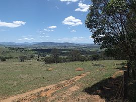
Kagaru is a rural locality split between Scenic Rim Region and City of Logan, Queensland, Australia. In the 2016 census, Kagaru had a population of 13 people.

Limestone Ridges is a rural locality in the Scenic Rim Region, Queensland, Australia. In the 2016 census, Limestone Ridges had a population of 116 people.

Allenview, Queensland Suburb of Scenic Rim Region, Queensland, Australia

Allenview is a rural locality in the Scenic Rim Region, Queensland, Australia. In the 2016 census, Allenview had a population of 184 people.

Mount Alford, Queensland Town in Queensland, Australia

Mount Alford is a rural town and locality in the Scenic Rim Region, Queensland, Australia. In the 2016 census, the locality of Mount Alford had a population of 268 people.

Laravale, Queensland Town in Queensland, Australia

Laravale is a rural locality in the Scenic Rim Region, Queensland, Australia. In the 2016 census, Laravale had a population of 189 people.

Frazerview, Queensland Suburb of Scenic Rim Region, Queensland, Australia

Frazerview is a rural locality in the Scenic Rim Region, Queensland, Australia. In the 2016 census, Frazerview had a population of 34 people.

Teviotville, Queensland Town in Queensland, Australia

Teviotville is a rural locality in the Scenic Rim Region, Queensland, Australia. In the 2016 census, Teviotville had a population of 125 people.

Knapp Creek, Queensland Suburb of Scenic Rim Region, Queensland, Australia

Knapp Creek is a rural locality in the Scenic Rim Region, Queensland, Australia. In the 2016 census, Knapp Creek had a population of 59 people.

Coulson, Queensland Suburb of Scenic Rim Region, Queensland, Australia

Coulson is a rural locality in the Scenic Rim Region, Queensland, Australia. In the 2016 census, Coulson had a population of 195 people.

Charlwood, Queensland Suburb of Scenic Rim Region, Queensland, Australia

Charlwood is a rural locality in the Scenic Rim Region, Queensland, Australia. In the 2016 census ,Charlwood had a population of 139 people.

Bunjurgen, Queensland Suburb of Scenic Rim Region, Queensland, Australia

Bunjurgen is a rural locality in the Scenic Rim Region, Queensland, Australia. In the 2016 census, Bunjurgen had a population of 116 people.

Carneys Creek, Queensland Suburb of Scenic Rim Region, Queensland, Australia

Carneys Creek is a rural locality in the Scenic Rim Region, Queensland, Australia. In the 2016 census, Carneys Creek had a population of 51 people. It borders New South Wales.

Chinghee Creek is a rural locality in the Scenic Rim Region, Queensland, Australia. In the 2016 census, Chinghee Creek had a population of 30 people.

Moogerah, Queensland Suburb of Scenic Rim Region, Queensland, Australia

Moogerah is a rural locality in the Scenic Rim Region, Queensland, Australia. In the 2016 census, Moogerah had a population of 234 people.

Croftby is a rural locality in the Scenic Rim Region, Queensland, Australia. In the 2016 census, Croftby had a population of 133 people. The town of Teviot is within the locality.

Mount Edwards, Queensland Suburb of Scenic Rim Region, Queensland, Australia

Mount Edwards is a rural locality in the Scenic Rim Region, Queensland, Australia. In the 2016 census, Mount Edwards had a population of 63 people.

Frenches Creek, Queensland Suburb of Scenic Rim Region, Queensland, Australia

Frenches Creek is a rural locality in the Scenic Rim Region, Queensland, Australia. In the 2016 census, Frenches Creek had a population of 85 people.

Wallaces Creek is a rural locality in the Scenic Rim Region, Queensland, Australia. In the 2016 census, Wallaces Creek had a population of 58 people.

References

  1. 1 2 3 Australian Bureau of Statistics (27 June 2017). "Allandale (SSC)". 2016 Census QuickStats. Retrieved 20 October 2018. OOjs UI icon edit-ltr-progressive.svg
  2. "Allandale – locality in Scenic Rim Region (entry 45104)". Queensland Place Names. Queensland Government . Retrieved 7 March 2022.
  3. Queensland Family History Society (2010), Queensland schools past and present (Version 1.01 ed.), Queensland Family History Society, ISBN   978-1-921171-26-0
  4. "Queensland Two Mile series sheet 2m38" (Map). Queensland Government. 1955. Archived from the original on 21 June 2021. Retrieved 12 August 2021.
  5. "Queensland Globe". State of Queensland . Retrieved 12 August 2021.

Commons-logo.svg Media related to Allandale, Queensland at Wikimedia Commons