Fassifern Valley, Queensland

Last updated

Fassifern Valley
Queensland
Fields in Fassifern Valley.jpg
Fields in Fassifern Valley
Australia Queensland location map.svg
Red pog.svg
Fassifern Valley
Coordinates 27°58′20″S152°36′22″E / 27.9722°S 152.6061°E / -27.9722; 152.6061 (Fassifern Valley (centre of locality))
Population112 (2021 census) [1]
 • Density12.73/km2 (33.0/sq mi)
Postcode(s) 4309
Area8.8 km2 (3.4 sq mi)
Time zone AEST (UTC+10:00)
Location
LGA(s) Scenic Rim Region
State electorate(s) Scenic Rim
Federal division(s) Wright
Suburbs around Fassifern Valley:
Fassifern Kalbar Kalbar
Morwincha Fassifern Valley Templin
Charlwood Charlwood Mount French

Fassifern Valley is a rural locality in the Scenic Rim Region, Queensland, Australia. [2] In the 2021 census, Fassifern Valley had a population of 112 people. [1]

Contents

Geography

Reynolds Creek forms the western boundary. [3]

The Boonah–Fassifern Road (State Route 90) runs through from east to west.

Tenders were called in October 1905 to erect a provisional school. [4] Fassifern Valley Provisional School opened on 13 March 1906. It became Fassifern State School on 1 January 1909. It closed in 1958 and its students transferred to Engelsburg State School in Kalbar (later renamed Kalbar State School). [5] [6] It was at 16 Tutin Road ( 27°58′11″S152°36′31″E / 27.9697°S 152.6085°E / -27.9697; 152.6085 (Fassifern Valley State School (former)) ). [7] [8] [9]

The first stage of the Mount Edwards railway line reached Engelsburg (now Kalbar) on 17 April 1916, [10] but it was not until 7 October 1922 that the second and final stage of the line opened, including the Fassifern Valley railway station on Charlwood Road (now Lake Moogerah Road, 27°58′23″S152°35′59″E / 27.97297°S 152.59979°E / -27.97297; 152.59979 (Fassifern Valley railway station) ). [10] [11] [12] The Mount Edwards railway line closed on 1 November 1960. [13] [14]

In the 2016 census, Fassifern Valley had a population of 91 people. The locality contains 41 households, in which 56.0% of the population are males and 44.0% of the population are females with a median age of 41, 3 years above the national average. The average weekly household income is $1,145, $293 below the national average. [15]

Demographics

In the 2016 census, Fassifern Valley had a population of 91 people. [15]

In the 2021 census, Fassifern Valley had a population of 112 people. [1]

Education

There are no schools in Fassifern Valley. The nearest government primary schools are Kalbar State School in neighbouring Kalbar to the north and Aratula State School in Aratula to the south-west. The nearest government secondary school is Boonah State High School in Boonah to the south-east. [9]

Related Research Articles

<span class="mw-page-title-main">Roadvale, Queensland</span> Town in Queensland, Australia

Roadvale is a rural locality in the Scenic Rim Region, Queensland, Australia. In the 2021 census, Roadvale had a population of 303 people.

<span class="mw-page-title-main">Aratula</span> Town in Queensland, Australia

Aratula is a rural town and locality in the Scenic Rim Region, Queensland, Australia. In the 2016 census, the locality of Aratula had a population of 532 people.

<span class="mw-page-title-main">Shire of Boonah</span> Local government area in Queensland, Australia

The Shire of Boonah was a local government area in South East Queensland, Australia, about 80 kilometres (50 mi) southwest of Brisbane. The shire covered an area of 1,921.6 square kilometres (741.9 sq mi), and existed from 1880 until its merger with parts of the Shire of Beaudesert and City of Ipswich to form the Scenic Rim Region on 15 March 2008.

<span class="mw-page-title-main">Fassifern Valley</span>

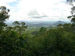
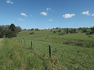
Fassifern Valley is a valley of the Scenic Rim in South East Queensland. Towns found in the valley include Harrisville, Kalbar, Roadvale, Warril View and Aratula. Fassifern Valley is known as a carrot-producing area, as well as for growing potatoes, onions, pumpkins and melons. It is one of four vegetable-producing regions in southern Queensland, the others being the Lockyer Valley, the eastern Darling Downs and the Granite Belt.

<span class="mw-page-title-main">Dugandan railway line</span> Railway line in Queensland, Australia

The Dugandan railway line was a branch railway in the Scenic Rim region of South East Queensland, Australia. It was also known as the Fassifern railway line. It operated from 1882 to 1964.

<span class="mw-page-title-main">Kalbar, Queensland</span> Town in Queensland, Australia

Kalbar is a rural town and locality in the Scenic Rim Region, Queensland, Australia. In the 2016 census, the locality of Kalbar had a population of 1,093 people.

<span class="mw-page-title-main">Munbilla, Queensland</span> Town in Queensland, Australia

Munbilla is a rural town and locality in the Scenic Rim Region, Queensland, Australia. In the 2016 census, the locality of Munbilla had a population of 100 people.

<span class="mw-page-title-main">Templin, Queensland</span> Suburb of Scenic Rim Region, Queensland, Australia

Templin is a rural locality in the Scenic Rim Region, Queensland, Australia. In the 2016 census, Templin had a population of 86 people.

<span class="mw-page-title-main">Silverdale, Queensland</span> Suburb of Scenic Rim Region, Queensland, Australia

Silverdale is a rural locality in the Scenic Rim Region, Queensland, Australia. In the 2021 census, Silverdale had a population of 112 people.

<span class="mw-page-title-main">Frazerview, Queensland</span> Suburb of Scenic Rim Region, Queensland, Australia

Frazerview is a rural locality in the Scenic Rim Region, Queensland, Australia. In the 2021 census, Frazerview had a population of 36 people.

<span class="mw-page-title-main">Teviotville, Queensland</span> Town in Queensland, Australia

Teviotville is a rural locality in the Scenic Rim Region, Queensland, Australia. In the 2021 census, Teviotville had a population of 114 people.

<span class="mw-page-title-main">Charlwood, Queensland</span> Suburb of Scenic Rim Region, Queensland, Australia

Charlwood is a rural locality in the Scenic Rim Region, Queensland, Australia. In the 2021 census, Charlwood had a population of 146 people.

<span class="mw-page-title-main">Fassifern, Queensland</span> Suburb of Scenic Rim Region, Queensland, Australia

Fassifern is a rural locality in the Scenic Rim Region, Queensland, Australia. In the 2021 census, Fassifern had a population of 18 people.

<span class="mw-page-title-main">Milbong, Queensland</span> Suburb of Scenic Rim Region, Queensland, Australia

Milbong is a rural locality in the Scenic Rim Region, Queensland, Australia. In the 2016 census, Milbong had a population of 161 people.

<span class="mw-page-title-main">Moogerah, Queensland</span> Suburb of Scenic Rim Region, Queensland, Australia

Moogerah is a rural locality in the Scenic Rim Region, Queensland, Australia. In the 2016 census, Moogerah had a population of 234 people.

<span class="mw-page-title-main">Mount Edwards, Queensland</span> Suburb of Scenic Rim Region, Queensland, Australia

Mount Edwards is a rural locality in the Scenic Rim Region, Queensland, Australia. In the 2016 census, Mount Edwards had a population of 63 people.

Anthony is a rural locality in the Scenic Rim Region, Queensland, Australia. In the 2021 census, Anthony had a population of 133 people.

Obum Obum is a rural locality in the Scenic Rim Region, Queensland, Australia. In the 2021 census, Obum Obum had a population of 129 people.

Kulgun is a locality in the Scenic Rim Region, Queensland, Australia. In the 2021 census, Kulgun had a population of 104 people.

Morwincha is a rural locality in the Scenic Rim Region, Queensland, Australia. In the 2016 census, Morwincha had a population of 30 people.

References

  1. 1 2 3 Australian Bureau of Statistics (28 June 2022). "Fassifern Valley (SAL)". 2021 Census QuickStats. Retrieved 28 February 2023. OOjs UI icon edit-ltr-progressive.svg
  2. "Fassifern Valley – locality in Scenic Rim Region (entry 45138)". Queensland Place Names. Queensland Government . Retrieved 20 July 2021.
  3. Google (18 January 2022). "Fassifern Valley, Queensland" (Map). Google Maps . Google. Retrieved 18 January 2022.
  4. "Official Notifications". The Telegraph . No. 10, 280. Queensland, Australia. 28 October 1905. p. 2 (SECOND EDITION). Retrieved 10 September 2022 via National Library of Australia.
  5. Queensland Family History Society (2010), Queensland schools past and present (Version 1.01 ed.), Queensland Family History Society, ISBN   978-1-921171-26-0
  6. "History". Kalbar State School. 4 January 2019. Archived from the original on 18 November 2019. Retrieved 18 November 2019.
  7. "Moreton 40 Chain map AG2 series sheet 25 south" (Map). Queensland Government. 1915. Archived from the original on 11 August 2021. Retrieved 11 August 2021.
  8. "Flinders" (Map). Queensland Government. 1927. Archived from the original on 29 May 2020. Retrieved 11 August 2021.
  9. 1 2 "Queensland Globe". State of Queensland . Retrieved 14 December 2021.
  10. 1 2 Kerr, John (1990). Triumph of narrow gauge : a history of Queensland Railways. Boolarong Publications. p. 224. ISBN   978-0-86439-102-5.
  11. "Queensland Two Mile series sheet 2m38" (Map). Queensland Government. 1955. Archived from the original on 21 June 2021. Retrieved 4 January 2022.
  12. "Queensland Globe". State of Queensland . Retrieved 4 January 2022.
  13. Southern Downs Steam Railway (2009). "'Via recta' - The line that never was". Archived from the original on 12 September 2009. Retrieved 25 October 2009.
  14. QR Limited. "Rail as foremost mode of travel". Archived from the original on 12 September 2009. Retrieved 25 October 2009.
  15. 1 2 Australian Bureau of Statistics (27 June 2017). "Fassifern Valley (SSC)". 2016 Census QuickStats. Retrieved 20 October 2018. OOjs UI icon edit-ltr-progressive.svg

Further reading