Christmas Creek, Queensland

Last updated

Christmas Creek
Queensland
Paddocks at Christmas Creek.jpg
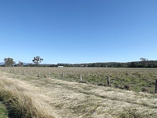
Fields along Christmas Creek Road, 2014
Australia Queensland location map.svg
Red pog.svg
Christmas Creek
Coordinates 28°10′52″S152°59′23″E / 28.1811°S 152.9897°E / -28.1811; 152.9897 (Christmas Creek (centre of locality)) Coordinates: 28°10′52″S152°59′23″E / 28.1811°S 152.9897°E / -28.1811; 152.9897 (Christmas Creek (centre of locality))
Population53 (2016 census) [1]
 • Density1.286/km2 (3.33/sq mi)
Postcode(s) 4285
Area41.2 km2 (15.9 sq mi)
Time zone AEST (UTC+10:00)
Location
LGA(s) Scenic Rim Region
State electorate(s) Scenic Rim
Federal division(s) Wright
Suburbs around Christmas Creek:
Tabooba Tabooba Kerry
Oaky Creek Christmas Creek Kerry
Oaky Creek Hillview Darlington

Christmas Creek is a rural locality in the Scenic Rim Region, Queensland, Australia. [2] In the 2016 census, Christmas Creek had a population of 53 people. [1]

Contents

Geography

The eastern border of the locality is marked by the high point of the Jinbroken Range while the west is similar defined by another ridgeline. Christmas Creek, a tributary of the Logan River flows in north–south direction roughly parallel to the only main road in the area called Christmas Creek Road.

History

Bullock teams transporting timber, 1910 StateLibQld 1 390841 Bullock teams hauling timber to the railway at Christmas Creek ca. 1910.jpg
Bullock teams transporting timber, 1910

Like many places in South East Queensland the first industry to developed was timber-getting.

Between 1872 and 1877 land was resumed from the Telemon pastoral run. Some of this land makes up what is now Christmas Creek. [3] [4] Agriculture soon became the area's main industry.

In 1877 the name of the post office changed from Telemon to Christmas Creek. [5] [6]

Christmas Creek Provisional School opened on 23 September 1878 but closed on 8 July 1881. [7]

Christmas Creek Provisional opened on 5 July 1887 (higher up the creek than the previous school). In 1901 it became Christmas Creek State School. In 1914, the school was renamed Hillview State School. [7]

Buddi (also spelled Buddai) Provisional School opened either in 1878 or 1904 and closed on 1908. [7] [8] [9] It was on Strong Road (approx 28°11′20″S152°59′03″E / 28.1890°S 152.9843°E / -28.1890; 152.9843 (Buddi / Buddai Provisional School) ) and there is monument at the site. [10]

The Beaudesert Shire Tramway had a station at Christmas Creek. The station was once known as Lillybank and for several years was the line's terminus. [11]

In the 2016 census, Christmas Creek had a population of 53 people. [1] The locality contained 34 households, in which 50.0% of the population were males and 50.0% of the population were females with a median age of 54, 16 years above the national average. The average weekly household income was $933, $505 below the national average. [1]

Heritage listings

Sacred Heart Catholic Church, 2005 Church with sign and gate, Sacred Heart Catholic Church, Christmas Creek, 2005.jpg
Sacred Heart Catholic Church, 2005

Christmas Creek has the following heritage sites:

Education

There are no schools in Christmas Creek. The nearest primary school is Hillview State School in neighbouring Hillview. The nearest secondary school is Beaudesert State High School in Beaudesert . [13]

Related Research Articles

<span class="mw-page-title-main">Rathdowney, Queensland</span> Town in Queensland, Australia

Rathdowney is a rural town and locality in the Scenic Rim Region, Queensland, Australia. In the 2016 census, Rathdowney had a population of 308 people.

<span class="mw-page-title-main">Beaudesert, Queensland</span> Town in Queensland, Australia

Beaudesert is a rural town and locality in the Scenic Rim Region, Queensland, Australia. In the 2016 census, Beaudesert had a population of 6,395 people.

<span class="mw-page-title-main">Bromelton, Queensland</span> Town in Queensland, Australia

Bromelton is a rural locality in the Scenic Rim Region, Queensland, Australia. In the 2016 census, Bromelton had a population of 155 people.

<span class="mw-page-title-main">Nindooinbah, Queensland</span> Suburb of Scenic Rim Region, Queensland, Australia

Nindooinbah is a rural locality in the Scenic Rim Region, Queensland, Australia. In the 2016 census, Nindooinbah had a population of 80 people.

<span class="mw-page-title-main">Kerry, Queensland</span> Town in Queensland, Australia

Kerry is a rural locality in the Scenic Rim Region, Queensland, Australia. In the 2016 census, Kerry had a population of 326 people.

<span class="mw-page-title-main">Barney View, Queensland</span> Suburb of Scenic Rim Region, Queensland, Australia

Barney View is a rural locality in the Scenic Rim Region, Queensland, Australia. In the 2016 census, Barney View had a population of 64 people.

<span class="mw-page-title-main">Tamborine, Queensland</span> Suburb of Logan City, Queensland, Australia

Tamborine is a rural town in the Scenic Rim Region and a locality split between the Scenic Rim Region and the City of Logan in Queensland, Australia. In the 2016 census, the locality of Tamborine had a population of 3,950 people.

<span class="mw-page-title-main">Darlington, Queensland</span> Suburb of Scenic Rim Region, Queensland, Australia

Darlington is a rural locality in the Scenic Rim Region, Queensland, Australia. In the 2016 census, Darlington had a population of 88 people.

<span class="mw-page-title-main">Hillview, Queensland</span> Town in Queensland, Australia

Hillview is a rural town and locality in the Scenic Rim Region, Queensland, Australia. In the 2016 census, the locality of Hillview had a population of 74 people.
<span class="mw-page-title-main">Tabooba, Queensland</span> Suburb of Scenic Rim Region, Queensland, Australia

Tabooba is a rural locality in the Scenic Rim Region, Queensland, Australia. In the 2016 census, Tabooba had a population of 72 people.

<span class="mw-page-title-main">Laravale, Queensland</span> Town in Queensland, Australia

Laravale is a rural locality in the Scenic Rim Region, Queensland, Australia. In the 2016 census, Laravale had a population of 189 people.

<span class="mw-page-title-main">Palen Creek, Queensland</span> Suburb of Scenic Rim Region, Queensland, Australia

Palen Creek is a rural locality in the Scenic Rim Region, Queensland, Australia. It borders New South Wales. In the 2016 census, Palen Creek had a population of 280 people.

<span class="mw-page-title-main">Mount Gipps, Queensland</span> Suburb of Scenic Rim Region, Queensland, Australia

Mount Gipps is a rural locality in the Scenic Rim Region, Queensland, Australia. In the 2016 census, Mount Gipps had a population of 7 people.
<span class="mw-page-title-main">Innisplain, Queensland</span> Suburb of Scenic Rim Region, Queensland, Australia

Innisplain is a rural locality in the Scenic Rim Region, Queensland, Australia. In the 2016 census, Innisplain had a population of 85 people.

<span class="mw-page-title-main">Oaky Creek, Queensland</span> Suburb of Scenic Rim Region, Queensland, Australia

Oaky Creek is a rural locality in the Scenic Rim Region, Queensland, Australia. In the 2016 census Oaky Creek had a population of 83 people.

<span class="mw-page-title-main">Running Creek, Queensland</span> Suburb of Scenic Rim Region, Queensland, Australia

Running Creek is a rural locality in the Scenic Rim Region, Queensland, Australia. In the 2016 census, Running Creek had a population of 147 people. It borders New South Wales.

<span class="mw-page-title-main">Cryna, Queensland</span> Suburb of Scenic Rim Region, Queensland, Australia

Cryna is a rural locality in the Scenic Rim Region, Queensland, Australia. In the 2016 census, Cryna had a population of 113 people.

<span class="mw-page-title-main">Lamington, Queensland</span> Suburb of Scenic Rim Region, Queensland, Australia

Lamington is a rural locality in the Scenic Rim Region, Queensland, Australia. In the 2016 census, Lamington had a population of 86 people.

<span class="mw-page-title-main">Gleneagle, Queensland</span> Suburb of Scenic Rim Region, Queensland, Australia

Gleneagle is a rural locality in the Scenic Rim Region, Queensland, Australia. In the 2016 census, Gleneagle had a population of 1,877 people.

Chinghee Creek is a rural locality in the Scenic Rim Region, Queensland, Australia. In the 2016 census, Chinghee Creek had a population of 30 people.

References

  1. 1 2 3 4 Australian Bureau of Statistics (27 June 2017). "Christmas Creek (SSC)". 2016 Census QuickStats. Retrieved 20 October 2018. OOjs UI icon edit-ltr-progressive.svg
  2. "Christmas Creek – locality in Scenic Rim Region (entry 45128)". Queensland Place Names. Queensland Government . Retrieved 20 July 2021.
  3. "Classified Advertising". The Brisbane Courier . Vol. XXVII, no. 4, 744. Queensland, Australia. 13 December 1872. p. 1. Archived from the original on 5 February 2023. Retrieved 4 February 2023 via National Library of Australia.
  4. "Proclamations under the New Land Acts". The Brisbane Courier . Queensland, Australia. 2 March 1877. p. 3. Archived from the original on 27 August 2020. Retrieved 19 February 2020 via Trove.
  5. "TELEMON". The Telegraph . No. 1, 347. Queensland, Australia. 5 February 1877. p. 3. Archived from the original on 5 February 2023. Retrieved 4 February 2023 via National Library of Australia.
  6. "Colonial News". Maryborough Chronicle, Wide Bay and Burnett Advertiser . No. 2079. Queensland, Australia. 15 December 1877. p. 4. Archived from the original on 5 February 2023. Retrieved 4 February 2023 via National Library of Australia.
  7. 1 2 3 Queensland Family History Society (2010), Queensland schools past and present (Version 1.01 ed.), Queensland Family History Society, ISBN   978-1-921171-26-0
  8. "Advertising". The Beaudesert Times . Queensland, Australia. 22 September 1922. p. 7. Archived from the original on 9 December 2021. Retrieved 30 April 2020 via Trove.
  9. "Education". The Beaudesert Times . Queensland, Australia. 13 August 1909. p. 6. Archived from the original on 9 December 2021. Retrieved 2 May 2020 via Trove.
  10. "Christmas Creek School Monument". Monument Australia. Archived from the original on 2 January 2015. Retrieved 1 May 2020.
  11. "Christmas Creek Tramway Monument". Monument Australia. Archived from the original on 4 September 2014. Retrieved 2 September 2014.
  12. "Local Heritage Register" (PDF). Scenic Rim Regional Council. Archived from the original (PDF) on 24 September 2015. Retrieved 9 February 2015.
  13. "Queensland Globe". State of Queensland . Retrieved 3 May 2020.

Commons-logo.svg Media related to Christmas Creek, Queensland at Wikimedia Commons