Moreton Bay Region

Last updated

City of Moreton Bay
Queensland
MoretonBayRegion-QldLGA.svg
Location within South East Queensland
Population
 • Density208.28/km2 (539.44/sq mi)
Established2008
Area2,042 km2 (788.4 sq mi) [3]
Mayor Peter Flannery
Council seat Strathpine, Caboolture, Redcliffe
Region South East Queensland
State electorate(s) Bancroft, Ferny Grove, Kurwongbah, Morayfield, Glass House, Murrumba, Pumicestone, Redcliffe, Everton, Pine Rivers
Federal division(s) Petrie, Dickson, Longman
Moreton-bay-regional-council-brand-2009.svg
Website City of Moreton Bay
LGAs around City of Moreton Bay:
Somerset Sunshine Coast Moreton Bay
Somerset City of Moreton BayMoreton Bay
Somerset Brisbane Brisbane

The City of Moreton Bay is a local government area in the north of the Brisbane metropolitan city in South East Queensland, Australia. Established in 2008, it replaced three established local government areas, the City of Redcliffe and the Shires of Pine Rivers and Caboolture.

Contents

With an estimated operating budget of A$391 million and a 2018 population of 459,585, [3] Moreton Bay Region is the third most populous local government area in Australia behind the City of Brisbane and City of Gold Coast, [3] both of which are also amalgamated entities.

History

The original inhabitants, or Traditional Owners, of the Moreton Bay Region are the Kabi Kabi, Jinibara and Turrbal Aboriginal people.

Duungidjawu (also known as Kabi Kabi, Cabbee, Carbi, Gabi Gabi) is an Australian Aboriginal language spoken on Duungidjawu country. The Duungidjawu language region includes the landscape within the local government boundaries of Somerset Region and Moreton Bay Region, particularly the towns of Caboolture, Kilcoy, Woodford and Moore . [4]

Prior to 2008, the new Moreton Bay Region was an entire area of three previous and distinct local government areas:

At the time the Divisional Boards Act 1879 came into force on 11 November 1879, the present Morton Bay Region was entirely contained within the Caboolture Division, which also included the Sunshine Coast. By 1890, Caboolture Division had shrunk considerably with the separate incorporation of the Pine Division (21 January 1888), Redcliffe Division (5 April 1888) and Maroochy Division (5 July 1890).

With the passage of the Local Authorities Act 1902, Caboolture, Pine and Redcliffe (as well as Maroochy) became Shires on 31 March 1903. Redcliffe was proclaimed a Town on 28 May 1921 and a City on 13 June 1959. A few weeks earlier, on 23 May 1959, Pine was renamed the Shire of Pine Rivers.

In July 2007, the Local Government Reform Commission released its report and recommended that the three areas amalgamate. [5] It argued that the area was part of the South East Queensland Regional Plan's Urban Footprint, and would attract 11% of the region's population and housing growth to 2006. A very strong community of interest was identified through the region's links and dependencies to Brisbane. The councils disagreed with the commission's plans although, with the exception of Redcliffe, did not oppose alternative amalgamation options. On 15 March 2008, the City and Shires formally ceased to exist, and elections were held on the same day to elect councillors and a mayor to the Regional Council. In 2012, following the election of the LNP state government, Redcliffe sought to enter a de-amalgamation process; however, a deadline to gather signatures on a petition by 29 August 2012 was missed. The Hills District sought in 2011 to transfer to Brisbane City Council, but the local government Change Commissioner declined the proposal on cost grounds.

On 8 December 2021, the council unanimously voted to rename the council area to Moreton Bay City and to seek approval from the Local Government Change Commission for the renaming. [6]

In April 2023, the Queensland Government decided to reflect the growing population of the region by creating five new localities named Corymbia, Greenstone, Lilywood, Wagtail Grove, and Waraba by excising parts of the existing localities of Bellmere, Rocksberg, Upper Caboolture, and Wamuran. [7] [8] [9]

Moreton Bay Regional Council
Leadership
Mayor
Deputy Mayor
Jodie Shipway
Structure
Australia Moreton Bay Region Council 2020.svg
Council political groups
  LNP (1)
  Labor (2)

  Independent (9)
Elections
Council last election
28 March 2020

Moreton Bay Region is divided into 12 divisions, each of which elects one councillor to the Regional Council. Additionally, the entire Region elects a mayor. Allan Sutherland was elected as the Region's first mayor at the 2008 elections, and Peter Flannery as the second Mayor in 2020. The current elected councillors are:

2020 Councillors: [10]

DivisionCouncillorDeclared political membershipYears ElectedElected to replace
Division 1Brooke SavigeIndependent2016, 2020Sitting Councillor
Division 2Mark BoothIndependent2020Peter Flannery
Division 3Adam HainIndependent2016, 2020Sitting Councillor
Division 4Jodie Shipway (Deputy Mayor)Independent2020Julie Greer
Division 5Sandra RuckIndependent2020James Houghton
Division 6Karl Winchester ALP 2020Koliana Winchester
Division 7Yvonne Barlow LNP 2021Denise Sims
Division 8Mick Gillam ALP 2008, 2012, 2016, 2020Sitting Councillor
Division 9Cath TonksIndependent2020Mike Charlton
Division 10Matthew ConstanceIndependent2016, 2020Sitting Councillor
Division 11 Darren Grimwade Independent2016, 2020Sitting Councillor
Division 12Tony LatterIndependent2020Adrian Raedel

Mayors

Deputy mayors

List of councillors

Division 1

TermNameNotes
2008–2016Gary ParsonsRetired
2016–presentBrooke SavigeIncumbent

Division 2

TermNameNotes
2008–2012 Chris Whiting Did not recontest in 2012; instead, unsuccessfully ran for mayor
2012–2020 Peter Flannery Did not recontest in 2020; instead, successfully ran for mayor. Mayor 2020–present
2020–presentMark BoothIncumbent

Division 3

TermNameNotes
2008–2016Greg ChippendaleDeputy mayor 2008–2013. Retired
2016–presentAdam HainIncumbent

Division 4

TermNameNotes
2008–2020Julie GreerRetired
2020–presentJodie ShipwayIncumbent. Deputy mayor 2021–present

Division 5

TermNameNotes
2008–2020James HoughtonRetired
2020–presentSandra RuckIncumbent

Division 6

TermNameNotes
2008–2012Rae FrawleyLost seat
2012–2020Koliana WinchesterRetired
2020–presentKarl WinchesterIncumbent

Division 7

TermNameNotes
2008–2016David DwyerRetired
2016–2021Denise SimsDeputy mayor 2020–2021. Resigned due to health [14]
2021–presentYvonne BarlowIncumbent

Division 8

TermNameNotes
2008–presentMick GillamIncumbent

Division 9

TermNameNotes
2008–2020Mike CharltonDeputy mayor 2013–2020. Lost seat [15]
2020–presentCath TonksIncumbent

Division 10

TermNameNotes
2008–2016Brian BattersbyRetired [16]
2016–presentMatt ConstanceIncumbent

Division 11

TermNameNotes
2008–2016Bob MillarRetired
2016–present Darren Grimwade Incumbent

Division 12

TermNameNotes
2008–2020Adrian RaedelDid not recontest in 2020; instead, unsuccessfully ran for mayor
2020–presentTony LatterIncumbent

Unitywater

On 1 July 2010, Moreton Bay Regional Council's Water Services (along with Sunshine Coast Regional Council), moved over to the recently created water body, Unitywater. Unitywater was created by the Queensland Government as part of the State's takeover of South East Queensland's water facilities, dams and water supply networks. Moreton Bay, Sunshine Coast Regional Council and Noosa Shire Council are joint owners of Unitywater.

Suburbs

The Moreton Bay Region include the following places:

Redcliffe area

Pine Rivers area

Urban suburbs:

Rural localities:

Caboolture area

Population

The populations given relate to the component entities prior to 2008. The 2011 census was the first for the amalgamated council region.

YearPopulation
(Total)
(Caboolture)(Pine Rivers)(Redcliffe)
193311,9285,3164,6042,008
194719,4025,7164,8158,871
195427,2677,1016,30913,857
196139,3128,8778,76121,674
196650,78510,14913,30927,327
197172,95512,20726,18734,561
1976103,66919,40445,19239,073
1981133,05632,64458,18942,223
1986166,21047,49473,78344,933
1991205,74370,05287,89247,799
1996250,07798,859103,19248,026
2001286,532114,338122,30349,891
2005325,067131,667141,38052,020
2007344,878140,288150,87153,719
2009371,155151,290163,51056,355
2011389,684158,988172,59358,103
2016425,302---
2021476,340---

Demographics

Selected historical census data for Moreton Bay Region local government area
Census year2011 [17] 2016 [1]
PopulationEstimated residents on census night 378,045425,302
LGA rank in terms of size within Queensland3rdSteady2.svg 3rd
% of Queensland population8.73%Increase2.svg 9.04%
% of Australian population1.76%Increase2.svg 1.82%
Dwelling structure
Dwelling type Separate house 85.9%Decrease2.svg 83.0%
Semi-detached, terrace or townhouse 7.4%Increase2.svg  11.0%
Flat or apartment 5.7%Decrease2.svg 5.0%

Facilities

The Moreton Bay Regional Council operates libraries at Albany Creek, Arana Hills, Bongaree (Bribie Island), Burpengary, Caboolture, Deception Bay, North Lakes, Redcliffe, Strathpine, and Woodford. [18] It also operates a mobile library service on a fortnightly basis serving the suburbs of Beachmere, Bray Park, Dayboro, Donnybrook, Lawnton, Mount Glorious, Mount Mee, Mount Nebo, Mount Samson Petrie, Samford, Toorbul and Warner. [19]

Local heritage register

The Moreton Bay Regional Council maintains its local heritage register in two parts: [20]

Related Research Articles

<span class="mw-page-title-main">Petrie railway station</span> Railway station in Queensland, Australia

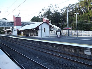
Petrie railway station is located on the North Coast line in Queensland, Australia. It serves the suburb of Petrie in the Moreton Bay Region. It opened as North Pine railway station in1888 after the nearby North Pine River and was renamed Petrie railway station in 1911.

<span class="mw-page-title-main">Redcliffe Peninsula</span> Town in Queensland, Australia

The Redcliffe Peninsula is a peninsula located in the Moreton Bay Region LGA in the northeast of the Brisbane metropolitan area in Queensland, Australia. The area covers the suburbs of Clontarf, Kippa-Ring, Margate, Newport, Redcliffe, Rothwell, Scarborough and Woody Point.

<span class="mw-page-title-main">Shire of Pine Rivers</span> Local government area in Queensland

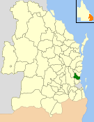
The Shire of Pine Rivers was a local government area about 20 kilometres (12 mi) north of Brisbane in the Moreton Bay region of South East Queensland, Australia. The shire covered an area of 771 square kilometres (297.7 sq mi), and existed as a local government entity from 1888 until 2008, when it amalgamated with councils further north and east to form the Moreton Bay Region.

<span class="mw-page-title-main">Shire of Noosa</span> Local government area in Queensland, Australia

The Shire of Noosa is a local government area about 130 kilometres (81 mi) north of Brisbane in the Sunshine Coast district of South East Queensland, Australia. The shire covers an area of 870 square kilometres (335.9 sq mi). It existed as a local government entity from 1910 until 2008, when it was amalgamated with the Shire of Maroochy and City of Caloundra to form the Sunshine Coast Region. The shire was re-established on 1 January 2014. In the 2021 census, the shire had a population of 56,298 people.

<span class="mw-page-title-main">Caboolture, Queensland</span> Suburb of Moreton Bay Region, Queensland, Australia

Caboolture is a town and suburb in Moreton Bay Region, Queensland, Australia. In the 2021 census, the suburb of Caboolture had a population of 29,534 people. It is located on the northern side of the Caboolture River.

<span class="mw-page-title-main">Strathpine, Queensland</span> Suburb of Moreton Bay Region, Queensland, Australia

Strathpine is a suburb in the Moreton Bay Region, Queensland, Australia. In the 2016 census, Strathpine had a population of 9,503 people. It is home to the Pine Rivers District offices of the Moreton Bay Region, as well as many businesses. The area is home to Strathpine Centre, a medium-sized urban shopping centre.

<span class="mw-page-title-main">Shire of Caboolture</span> Local government area in Queensland

The Shire of Caboolture was a local government area located in the Australian state of Queensland on the northern urban fringe of the capital, Brisbane, and south of the Sunshine Coast. The Shire covered an area of 1,224.4 square kilometres (472.7 sq mi), of which approximately one-quarter was urban, and existed as a local government entity from 1879 until 2008, when it amalgamated with the City of Redcliffe and Shire of Pine Rivers to form the Moreton Bay Region.

<span class="mw-page-title-main">City of Redcliffe</span> Local government area in Queensland, Australia

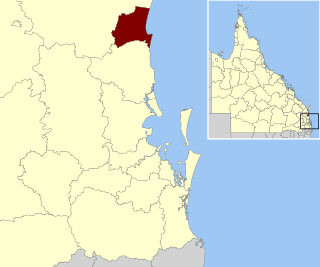
The City of Redcliffe is a former local government area in South East Queensland, Australia. In 2008 it was amalgamated with the Shires of Pine Rivers and Caboolture to create Moreton Bay Region. It is in the northern part of the County of Stanley, with a total area of 38.1 km² and a population of 51,174.

<span class="mw-page-title-main">City of Ipswich</span> Local government area in Queensland, Australia

The City of Ipswich is a local government area in Queensland, Australia, located within the southwest of the Brisbane metropolitan area, including the urban area surrounding the city of Ipswich and surrounding rural areas.

<span class="mw-page-title-main">Tablelands Region</span> Local government area in Queensland, Australia

The Tablelands Region is a local government area in Far North Queensland, Australia inland from the city of Cairns. Established in 2008, it was preceded by four previous local government areas which dated back more than a century. On 1 January 2014, one of those local government areas, the Shire of Mareeba, was re-established independent of the Tablelands Region.

<span class="mw-page-title-main">Fraser Coast Region</span> Local government area in Queensland, Australia

The Fraser Coast Region is a local government area in the Wide Bay–Burnett region of Queensland, Australia, about 250 kilometres (160 mi) north of Brisbane, the state capital. It is centred on the twin cities of Hervey Bay and Maryborough and also contains Fraser Island. It was created in 2008 from a merger of the Cities of Maryborough and Hervey Bay and the Shires of Woocoo and most of Tiaro. In June 2018 it had a population of 105,463.

<span class="mw-page-title-main">Somerset Region</span> Local government area in Queensland, Australia

The Somerset Region is a local government area located in the West Moreton region of South East Queensland, Australia, about 100 kilometres (62 mi) northwest of Brisbane and centred on the town of Esk. It was created in 2008 from a merger of the Shire of Esk and the Shire of Kilcoy. It is commonly known as the Brisbane Valley, due to the Brisbane River which courses through the region, although significant parts of the region lie outside the hydrological Brisbane Valley itself.

<span class="mw-page-title-main">Gympie Region</span> Local government area in Queensland, Australia

The Gympie Region is a local government area in the Wide Bay–Burnett region of Queensland, Australia, about 170 kilometres (110 mi) north of Brisbane, the state capital. It is between the Sunshine Coast and Hervey Bay and centred on the town of Gympie. It was created in 2008 from a merger of the Shires of Cooloola and Kilkivan and part of the Shire of Tiaro.

Bellmere is a rural locality in the Moreton Bay Region, Queensland, Australia. In the 2016 census, Bellmere had a population of 5,863 people.

<span class="mw-page-title-main">Wamuran, Queensland</span> Town in Queensland, Australia

Wamuran is a rural town and locality in the Moreton Bay Region, Queensland, Australia. In the 2016 census, the locality of Wamuran had a population of 3,196 people.

<span class="mw-page-title-main">Rocksberg</span> Suburb of Moreton Bay Region, Queensland, Australia

Rocksberg is a rural locality in the Moreton Bay Region, Queensland, Australia. In the 2016 census, Rocksberg had a population of 300 people.

Corymbia is a rural locality in the Moreton Bay Region, Queensland, Australia.

Greenstone is a rural locality in the Moreton Bay Region, Queensland, Australia.

Wagtail Grove is a rural locality in the Moreton Bay Region, Queensland, Australia.

Waraba is a rural locality in the Moreton Bay Region, Queensland, Australia.

References

  1. 1 2 Australian Bureau of Statistics (27 June 2017). "Moreton Bay (R)". 2016 Census QuickStats. Retrieved 8 February 2020. OOjs UI icon edit-ltr-progressive.svg
  2. "3218.0 – Regional Population Growth, Australia, 2018-19". Australian Bureau of Statistics. 2 July 2020. Archived from the original on 3 July 2020. Retrieved 2 July 2020. Estimated resident population (ERP) at 30 June 2019.
  3. 1 2 3 "3218.0 – Regional Population Growth, Australia, 2017-18: Population Estimates by Local Government Area (ASGS 2018), 2017 to 2018". Australian Bureau of Statistics. Australian Bureau of Statistics. 27 March 2019. Archived from the original on 27 March 2019. Retrieved 25 October 2019. Estimated resident population, 30 June 2018.
  4. CC BY icon-80x15.png This Wikipedia article incorporates CC-BY-4.0 licensed text from: "Duungidjawu". Queensland Aboriginal and Torres Strait Islander languages map. State Library of Queensland . Retrieved 23 January 2020.
  5. Queensland Local Government Reform Commission (July 2007). Report of the Local Government Reform Commission (PDF). Vol. 2. pp. 234–239. ISBN   978-1-921057-11-3. Archived from the original (PDF) on 17 March 2011. Retrieved 3 June 2010.
  6. Stone, Lucy (8 December 2021). "Moreton Bay Regional Council to rename itself to Moreton Bay City". ABC Radio Brisbane. ABC. ABC. Archived from the original on 8 December 2021. Retrieved 8 December 2021.
  7. "Current proposals and decisions". Place Names. Queensland Government. Archived from the original on 21 June 2023. Retrieved 12 July 2023.
  8. "Proposed Locality Names and Boundaries: Bellmere / Corymbia / Greenstone / Lilywood / Rocksberg / Upper Caboolture / Wagtail Grove / Wamuran / Waraba" (PDF) (Map). Queensland Government. 2 December 2022. Archived (PDF) from the original on 21 June 2023. Retrieved 12 July 2023.
  9. "Locality Names and Boundaries: Bellmere / Corymbia / Greenstone / Lilywood / Rocksberg / Upper Caboolture / Wagtail Grove / Wamuran / Waraba" (PDF) (Map). Queensland Government. 14 April 2023. Archived (PDF) from the original on 21 June 2023. Retrieved 12 July 2023.
  10. 1 2 "2020 Local Government Elections: Saturday, 28 March 2020". Electoral Commission of Queensland. 2020. Archived from the original on 16 June 2020. Retrieved 16 June 2020.
  11. "2008 Moreton Bay Regional Council - Mayoral Election - Election Summary". results.ecq.qld.gov.au. Archived from the original on 29 March 2016. Retrieved 4 December 2017.
  12. "2012 Moreton Bay Regional Council - Mayoral Election - Election Summary". results.ecq.qld.gov.au. Archived from the original on 5 April 2018. Retrieved 4 December 2017.
  13. "2016 Moreton Bay Regional Council - Mayoral Election - Election Summary". results.ecq.qld.gov.au. Archived from the original on 27 March 2018. Retrieved 4 December 2017.
  14. Read, Cloe (19 October 2021). "'Vulnerably honest': Moreton Bay Council Deputy Mayor resigns". Brisbane Times. Archived from the original on 1 September 2022. Retrieved 1 September 2022.
  15. Smith, Erin (17 April 2020). "Longtime Moreton Bay Regional Councillor and Deputy Mayor Mike Charlton has lost Division 9". The Courier Mail. Retrieved 30 August 2022.{{cite web}}: CS1 maint: url-status (link)
  16. "40 Year Councillor to Retire". www.moretonbay.qld.gov.au. Archived from the original on 1 September 2022. Retrieved 1 September 2022.
  17. Australian Bureau of Statistics (31 October 2012). "Moreton Bay (R)". 2011 Census QuickStats. Retrieved 8 February 2020. OOjs UI icon edit-ltr-progressive.svg
  18. "Library locations & opening hours - Libraries". Moreton Bay Regional Council. Archived from the original on 23 January 2018. Retrieved 22 January 2018.
  19. "Mobile Library - Libraries". Moreton Bay Regional Council. Archived from the original on 30 January 2018. Retrieved 22 January 2018.
  20. "Planning Scheme Policy: Heritage and Landscape Character" (PDF). Moreton Bay Regional Council . Archived (PDF) from the original on 22 May 2020. Retrieved 23 May 2020.

27°17′36″S152°55′48″E / 27.29333°S 152.93000°E / -27.29333; 152.93000