North Burnett Region

Last updated

North Burnett Region
Queensland
North burnett LGA Qld 2008.png
Location in Queensland
Population10,628 (2018) [1]
 • Density0.54032/km2 (1.3994/sq mi)
Established2008
Area19,670 km2 (7,594.6 sq mi) [1]
MayorLes Hotz
Council seat Gayndah
Region Wide Bay–Burnett
State electorate(s) Callide
Federal division(s) Flynn, Hinkler
NorthBurnettRegionalCouncil.jpg
LGAs around North Burnett Region:
Banana Gladstone Gladstone
Banana North Burnett Region Bundaberg
Western Downs South Burnett Gympie, Fraser Coast

The North Burnett Region is a local government area in Queensland, Australia in the northern catchment of the Burnett River. Established in 2008, it was preceded by several previous local government areas with histories extending back to the early 1900s.

Contents

It has an estimated operating budget of A$32  million.

History

Prior to the 2008 amalgamation, the North Burnett Region, located in the northern catchment of the Burnett River, existed as six distinct local government areas:

The first local government in the North Burnett area was the Gayndah Municipality, which was created on 28 November 1866 under the Municipal Corporations Act 1864. On 11 November 1879, the Rawbelle and Perry Divisions were created to serve regional areas under the Divisional Boards Act 1879. A third division, Eidsvold, was proclaimed on 25 January 1890.

On 31 March 1903, following the enactment of the Local Authorities Act 1902, Gayndah became a town while the three divisions became shires. On 3 June 1905, the Shire of Degilbo, centred on Biggenden, was established from part of the Shire of Burrum. On 19 May 1915, the Shire of Auburn (later renamed Mundubbera) was separately incorporated. On 17 March 1923, the Shire of Rawbelle was renamed Gayndah and on 24 May 1924, it absorbed the Town. On 3 March 1932, the Shire of Monto came into being and Eidsvold was reincorporated. Finally, on 12 July 1941, Degilbo was renamed Biggenden.

Council service centre, 2008 MundubberaWestpacBank.JPG
Council service centre, 2008

In July 2007, the Local Government Reform Commission released its report and recommended that the six areas amalgamate, asserting that there were "inefficiencies with having six local governments to manage the economic and community interests of a relatively small geographic region which has a static population of just over 10,000". It believed amalgamation would offer potential for both strategic planning and improving the quality of governance and decision-making, as well as allowing one of the towns to emerge as a regional centre for the area. Queensland Treasury had rated all of the councils for financial sustainability, with all except Perry and Biggenden attracting a weak rating. Each of the councils apart from Gayndah opposed the Commission's model, with several suggesting either amalgamation with one or two other shires, or with local governments outside the region (in particular the Shire of Kolan and Gladstone/Calliope). In the end, its proposal was unchanged. [2] On 15 March 2008, the Shires formally ceased to exist, and elections were held on the same day to elect councillors and a mayor to the Regional Council.

Wards and councillors

The Region is divided into six divisions, each electing one councillor, with a mayor elected by the entire Region. Joy Jensen, the mayor for the Shire of Perry, was elected at the March 2008 local government elections but was not re-elected in 2012. [3]

Mayors

Towns and localities

The North Burnett Region includes the following settlements:

Libraries

The North Burnett Regional Council operates public libraries at Biggenden, Eidsvold, Gayndah, Monto, Mount Perry, and Mundubbera. [10]

Planning scheme

The North Burnett Regional Council's first planning scheme commenced on 3 November 2014. [11] It replaced the six planning schemes prepared by the former Councils. As a scheme that follows the State-mandated structure it contains the following key components: a Strategic framework (Part 3), Priority infrastructure plan (Part 4), Tables of assessment (Part 5), Zones (Part 6), Overlays (Part 8), Other codes (Part 9), Definitions (Schedule 1), Mapping (Schedules 2 and 3) and Planning scheme policies (Schedule 6).

Planning scheme mapping is accessible via the Council's online interactive mapping. [12]

Heritage

On 5 May 2014, the North Burnett Regional Council published their first Local Heritage Register, containing 64 sites out of a proposed 71. [13]

Population

YearTotal RegionBiggendenEidsvoldGayndahMontoMundubberaPerry
193314,3222,4761,4753,7603,5142,302795
194713,8612,1791,3133,4074,2702,064628
195413,9171,9741,3113,3524,4582,326496
196113,9931,8821,2423,4004,3972,617455
196613,7151,7221,7023,1824,1552,580374
197112,2301,6391,2223,1073,4952,391376
197611,5041,5321,2312,8143,2282,395304
198111,5651,4111,2562,8593,2492,481309
198611,5831,5531,2122,8873,2662,355310
199111,2301,5741,0282,8563,0582,340374
199611,2431,5709702,9162,9222,514351
200110,7821,4869332,8942,5922,451426
200610,5511,5068762,9112,5772,236445
201610,478
202110,068

Related Research Articles

<span class="mw-page-title-main">Mundubbera</span> Town in Queensland, Australia

Mundubbera is a town and a locality in the North Burnett Region, Queensland, Australia. In the 2016 census, Mundubbera had a population of 1261 people.

<span class="mw-page-title-main">Burnett Highway</span> Highway in Queensland, Australia

The Burnett Highway is an inland rural highway located in Queensland, Australia. The highway runs from its junction with the Bruce Highway at Gracemere, just south of Rockhampton, to the D'Aguilar Highway in Nanango. Its length is approximately 542 kilometres. The highway takes its name from the Burnett River, which it crosses in Gayndah. The Burnett Highway provides the most direct link between the northern end of the New England Highway and Rockhampton. It is designated as a State Strategic Road by the Queensland Government.

<span class="mw-page-title-main">Eidsvold, Queensland</span> Town in Queensland, Australia

Eidsvold is a rural town and locality in the North Burnett Region, Queensland, Australia. The town is the self-proclaimed Beef Capital of the Burnett and is a hub for the regional cattle industry. In the 2016 census, the locality of Eidsvold had a population of 574 people.

<span class="mw-page-title-main">Shire of Perry</span> Local government area in Queensland, Australia

The Shire of Perry was a local government area in the northern catchment of the Burnett River, Queensland, Australia. The Shire covered an area of 2,357.7 square kilometres (910.3 sq mi), and existed as a local government area from 1880 until 2008, when it amalgamated with several other shires to form the North Burnett Region.

<span class="mw-page-title-main">Electoral district of Callide</span> State electoral district of Queensland, Australia

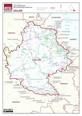
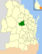
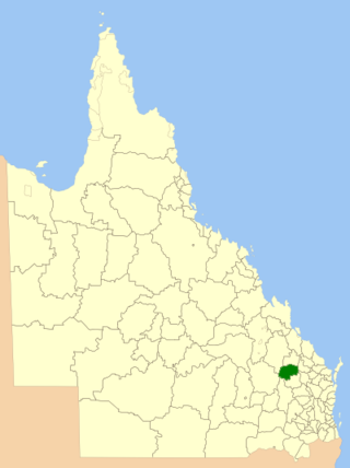
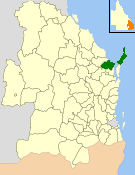
Callide is an electoral division in Queensland, Australia.

<span class="mw-page-title-main">Shire of Mundubbera</span> Local government area in Queensland, Australia

The Shire of Mundubbera was a local government area in the northern catchment of the Burnett River, Queensland, Australia. The shire covered an area of 4,192.8 square kilometres (1,618.8 sq mi), and existed as a local government area from 1915 until 2008, when it amalgamated with several other shires to form the North Burnett Region.

<span class="mw-page-title-main">Shire of Gayndah</span> Local government area in Queensland, Australia

The Shire of Gayndah was a local government area located in the northern catchment of the Burnett River, Queensland, Australia. The shire covered an area of 2,709.3 square kilometres (1,046.1 sq mi), and existed as a local government area from 1866 until 2008, when it amalgamated with several other shires to form the North Burnett Region.

<span class="mw-page-title-main">Shire of Monto</span> Local government area in Queensland, Australia

The Shire of Monto was a local government area in the northern catchment of the Burnett River, Queensland, Australia. The shire covered an area of 4,320.8 square kilometres (1,668.3 sq mi), and existed as a local government area from 1932 until 2008, when it amalgamated with several other shires to form the North Burnett Region.

<span class="mw-page-title-main">Shire of Eidsvold</span> Local government area in Queensland, Australia

The Shire of Eidsvold was a local government area in the northern catchment of the Burnett River, Queensland, Australia. The shire covered an area of 4,809.4 square kilometres (1,856.9 sq mi), and existed as a local government area from 1890 until 2008, when it amalgamated with several other shires to form the North Burnett Region.

<span class="mw-page-title-main">Shire of Biggenden</span> Local government area in Queensland, Australia

The Shire of Biggenden was a local government area located in the northern catchment of the Burnett River, Queensland, Australia, 100 kilometres (62 mi) south-southwest of the regional city of Bundaberg. The shire covered an area of 1,314.5 square kilometres (507.5 sq mi), and existed as a local government area from 1905 until 2008, when it amalgamated with several other shires to become the North Burnett Region.

<span class="mw-page-title-main">City of Hervey Bay</span> Local government area in Queensland, Australia

The City of Hervey Bay was a local government area located in the Wide Bay–Burnett region of Queensland, Australia, containing the urban centre of Hervey Bay as well as the northern half of Fraser Island. The City covered an area of 2,356.3 square kilometres (909.8 sq mi), and existed as a local government entity in various forms from 1879 until 2008, when it was amalgamated with the City of Maryborough, Shire of Woocoo and the 1st and 2nd divisions of the Shire of Tiaro to form the Fraser Coast Region.

<span class="mw-page-title-main">Cassowary Coast Region</span> Local government area in Queensland, Australia

The Cassowary Coast Region is a local government area in the Far North Queensland region of Queensland, Australia, south of Cairns and centred on the towns of Innisfail, Cardwell and Tully. It was created in 2008 from a merger of the Shire of Cardwell and the Shire of Johnstone.

<span class="mw-page-title-main">Tablelands Region</span> Local government area in Queensland, Australia

The Tablelands Region is a local government area in Far North Queensland, Australia inland from the city of Cairns. Established in 2008, it was preceded by four previous local government areas which dated back more than a century. On 1 January 2014, one of those local government areas, the Shire of Mareeba, was re-established independent of the Tablelands Region.

<span class="mw-page-title-main">Bundaberg Region</span> Local government area in Queensland, Australia

The Bundaberg Region is a local government area in the Wide Bay–Burnett region of Queensland, Australia, about 360 kilometres (220 mi) north of Brisbane, the state capital. It is centred on the city of Bundaberg, and also contains a significant rural area surrounding the city. It was created in 2008 from a merger of the City of Bundaberg with the Shires of Burnett, Isis and Kolan.

<span class="mw-page-title-main">Fraser Coast Region</span> Local government area in Queensland, Australia

The Fraser Coast Region is a local government area in the Wide Bay–Burnett region of Queensland, Australia, about 250 kilometres (160 mi) north of Brisbane, the state capital. It is centred on the twin cities of Hervey Bay and Maryborough and also contains Fraser Island (K'gari). It was created in 2008 from a merger of the Cities of Maryborough and Hervey Bay and the Shires of Woocoo and most of Tiaro. In June 2018 it had a population of 105,463.

<span class="mw-page-title-main">Gympie Region</span> Local government area in Queensland, Australia

The Gympie Region is a local government area in the Wide Bay–Burnett region of Queensland, Australia, about 170 kilometres (110 mi) north of Brisbane, the state capital. It is between the Sunshine Coast and Hervey Bay and centred on the town of Gympie. It was created in 2008 from a merger of the Shires of Cooloola and Kilkivan and part of the Shire of Tiaro.

<span class="mw-page-title-main">Mungar Junction to Monto railway line</span> Former railway line in Queensland, Australia

The Mungar Junction to Monto railway line is a 267-kilometre (166 mi) railway in Queensland, Australia. Progressively opened in eleven stages between 1889 and 1928 the line branched from the North Coast line at Mungar Junction a short distance west of Maryborough and followed a westerly route towards Biggenden and Gayndah before turning north via Mundubbera and Eidsvold to Monto. It is also known as the Gayndah Monto Branch Railway. In 2012, the line was officially closed.

<span class="mw-page-title-main">Didcot, Queensland</span> Suburb of North Burnett Region, Queensland, Australia

Didcot is a rural locality in the North Burnett Region, Queensland, Australia. In the 2016 census Didcot had a population of 60 people.

<span class="mw-page-title-main">Humphery Railway Bridge</span> Historic site in Queensland, Australia

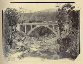
Humphery Railway Bridge is a heritage-listed railway bridge on the Mungar to Monto railway line at Humphery, North Burnett Region, Queensland, Australia. It was designed by William Pagan and built in 1913. It was added to the Queensland Heritage Register on 21 October 1992.

Mount Lawless is a rural locality in the North Burnett Region, Queensland, Australia. In the 2021 census, Mount Lawless had a population of 9 people.

References

  1. 1 2 "3218.0 – Regional Population Growth, Australia, 2017-18: Population Estimates by Local Government Area (ASGS 2018), 2017 to 2018". Australian Bureau of Statistics. Australian Bureau of Statistics. 27 March 2019. Retrieved 25 October 2019. Estimated resident population, 30 June 2018.
  2. Queensland Local Government Reform Commission (July 2007). Report of the Local Government Reform Commission (PDF). Vol. 2. pp. 228–233. ISBN   978-1-921057-11-3. Archived (PDF) from the original on 17 March 2011. Retrieved 17 September 2009.
  3. "2012 North Burnett Regional Council - Mayoral Election". Election Summary. Electoral Commission Queensland. 28 May 2012. Archived from the original on 4 April 2015. Retrieved 13 June 2015.
  4. "2008 North Burnett Regional Council - Mayoral Election - Election Summary". results.ecq.qld.gov.au. Archived from the original on 1 April 2016. Retrieved 4 December 2017.
  5. "2012 North Burnett Regional Council - Mayoral Election - Election Summary". results.ecq.qld.gov.au. Archived from the original on 4 April 2015. Retrieved 4 December 2017.
  6. "2016 North Burnett Regional Council - Mayoral Election - Election Summary". results.ecq.qld.gov.au. Archived from the original on 27 March 2018. Retrieved 4 December 2017.
  7. "2020 Local Government Elections: Saturday, 28 March 2020". Electoral Commission of Queensland. 2020. Archived from the original on 16 June 2020. Retrieved 16 June 2020.
  8. Loram, Lucy (21 September 2021). "Rachel Chambers resigns as Mayor of North Burnett". ABC Wide Bay. Archived from the original on 10 October 2021.
  9. "Meet Your Councillors". North Burnett Regional Council. February 2022. Archived from the original on 19 February 2022.
  10. "Library Services". Gympie Regional Council . Archived from the original on 31 January 2018. Retrieved 31 January 2018.
  11. "North Burnett Regional Council - Planning and Building". North Burnett Regional Council. Archived from the original on 13 March 2018. Retrieved 3 November 2018.
  12. "North Burnett Regional Council - Interactive Mapping". North Burnett Regional Council. Archived from the original on 13 March 2018. Retrieved 3 November 2018.
  13. "Local Heritage Register". North Burnett Regional Council. Archived from the original on 13 March 2018. Retrieved 3 November 2018.

Commons-logo.svg Media related to North Burnett Region at Wikimedia Commons

25°37′30″S151°36′20″E / 25.62500°S 151.60556°E / -25.62500; 151.60556