
Weipa is a coastal mining town in the local government area of Weipa Town in Queensland, Australia. It is the largest town on the Cape York Peninsula. It exists because of the enormous bauxite deposits along the coast. The Port of Weipa is mainly involved in exports of bauxite. There are also shipments of live cattle from the port.

The Shire of Aurukun is a local government area in Far North Queensland, Australia. The shire covers part of western Cape York Peninsula, the most northerly section of the Australian mainland.

Lockhart River is a town in the Aboriginal Shire of Lockhart River and a coastal locality split between the Aboriginal Shire of Lockhart River and the Shire of Cook, on the Cape York Peninsula in Queensland, Australia. In the 2016 census, Lockhart River had a population of 724 people.

Injinoo is a coastal town in the Northern Peninsula Area Region and a locality split between Northern Peninsula Area Region and the Shire of Torres in Far North Queensland, Australia. It is on the north-western coast of Cape York Peninsula. In the 2016 census, Injinoo had a population of 561 people.

Mapoon is a coastal town in the Aboriginal Shire of Mapoon and a locality split between the Aboriginal Shire of Mapoon and the Shire of Cook in Queensland, Australia.

The Shire of Diamantina is a local government area in Central West Queensland, bordering South Australia and the Northern Territory. Its administrative centre is in the town of Bedourie.
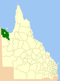
The Shire of Burke is a local government area in North West Queensland, Australia. The shire lies on the south coast of the Gulf of Carpentaria and abuts the border with the Northern Territory. It covers an area of 39,864 square kilometres (15,391.6 sq mi), and has existed as a local government entity since 1885. The major town and administrative centre of the shire is Burketown. The shire and town and the Burke River passing through all are named in honour of ill-fated explorer Robert O'Hara Burke.

The Shire of Cook is a local government area in Far North Queensland, Australia. The Shire covers most of the eastern and central parts of Cape York Peninsula, the most northerly section of the Australian mainland.

The Shire of Mornington is a local government area in north-west Queensland, Australia. The Shire covers Mornington Island and neighbouring islands in the Wellesley Islands group in the Gulf of Carpentaria. The Shire Council employees are 93% local indigenous residents.

The Aboriginal Shire of Doomadgee is a special local government area in North West Queensland, Queensland, Australia. It is managed under a Deed of Grant in Trust under the Local Government Act 2004.

The Northern Peninsula Area Region is a local government area in Far North Queensland, Australia, covering areas on the northwestern coast of Cape York Peninsula. It was created in March 2008 out of three Aboriginal Shires and two autonomous Island Councils during a period of statewide local government reform. In June 2018, the area had a population of 3,069.

The Aboriginal Shire of Kowanyama is a special local government area which is located on western Cape York Peninsula in Queensland, Australia. It is managed under a Deed of Grant in Trust under the Local Government Act 2004.

The Aboriginal Shire of Woorabinda is a local government area in Central Queensland, Australia.

The Aboriginal Shire of Pormpuraaw is a special local government area which is located on western Cape York Peninsula in Queensland, Australia. It is managed under a Deed of Grant in Trust under the Local Government Act 2004.

The Aboriginal Shire of Yarrabah is a special local government area in Far North Queensland, Queensland, Australia, east and southeast of Cairns on Cape Grafton. It is managed under a Deed of Grant in Trust under the Local Government Act 2004.
The Wujal Wujal Aboriginal Shire is a local government area in Far North Queensland, Australia. It is managed as a Deed of Grant in Trust under the Local Government Act 2004.

The Aboriginal Shire of Hope Vale is a local government area in Far North Queensland, Queensland, Australia, north of the town of Cooktown. The majority of the Shire consists of Deed of Grant land that is held for the benefit of Aboriginal people particularly concerned with the land and their ancestors and descendants.

Weipa Town is a local government area in Far North Queensland, Australia. It covers the town of Weipa on the western coast of the Cape York Peninsula, including the localities of Rocky Point, Trunding, Nanum, Evans Landing, and Weipa Airport. It is an unusual local government area as it is not governed and managed by a council elected by residents but rather by the company Rio Tinto Aluminium through a governing body called the Weipa Town Authority. In June 2018, Weipa Town had a population of 4,240.
The Aboriginal Shire of Lockhart River is a local government area in Far North Queensland, Australia.
The Aboriginal Shire of Mapoon is a local government area in Far North Queensland, Australia. It is on the western coast of Cape York Peninsula on the Gulf of Carpentaria.

