Shire of Mckinlay

Last updated

Shire of Mckinlay
Queensland
Mckinlay LGA Qld.png
Location within Queensland
Population814 (2018) [1]
 • Density0.019982/km2 (0.05175/sq mi)
Established1891
Area40,737 km2 (15,728.6 sq mi) [1]
MayorPhilip Roland Curr
Council seat Julia Creek
Region North West Queensland
State electorate(s) Traeger
Federal division(s) Kennedy
McKinlay Shire Council Logo.png
Website Shire of Mckinlay
LGAs around Shire of Mckinlay:
Carpentaria Carpentaria Croydon
Cloncurry Shire of Mckinlay Richmond
Cloncurry Winton Winton

The Shire of Mckinlay is a local government area in outback north-western Queensland, Australia.

Contents

It covers an area of 40,737 square kilometres (15,728.6 sq mi), and has existed as a local government entity since 1891. The shire economy is based on beef production and mining. BHP operate the Cannington Mine in the shire, extracting silver, lead and zinc.

History

Wanamarra (also known as Maykulan and Wunumura is an Australian Aboriginal language in North West Queensland. The language region includes areas within the Shire of McKinlay, Shire of Cloncurry and Shire of Richmond, including the Flinders River area, and the towns of Kynuna and Richmond. [2]

Map of McKinlay Division and adjacent local government areas, March 1902 McKinlay Division, March 1902.jpg
Map of McKinlay Division and adjacent local government areas, March 1902

The Mackinlay Division was created on 9 December 1891 out of parts of Boulia and Cloncurry under the Divisional Boards Act 1887.

With the passage of the Local Authorities Act 1902, Mackinlay Division became the Shire of Mackinlay on 31 March 1903.

In 1932, the spelling of the shire's name was altered to be Shire of Mckinlay, as the shire was named after the explorer John McKinlay. [3]

On 24 July 1930, it was abolished and a new Shire of Mckinlay was formed from parts of the Shires of Cloncurry, Mckinlay, Winton and Wyangarie (Richmond).

Towns and localities

The Shire of McKinlay includes the following settlements:

Amenities

The Mckinlay Shire Council operates public libraries at Julia Creek and McKinlay. [4]

Chairmen and mayors

Population

YearPopulation
19331,899
19471,633
19541,647
19612,132
19661,701
19711,582
19761,468
19811,477
19861,446
19911,306
19961,423
20011,358
20061,351
20111,050
2016796

Related Research Articles

<span class="mw-page-title-main">Shire of Paroo</span> Local government area in Queensland, Australia

The Shire of Paroo is a local government area in South West Queensland, Australia. The administrative centre is the town of Cunnamulla. The Paroo Shire covers an area of 47,623 square kilometres (18,387 sq mi). In the 2021 census, the Shire had a population of 1,679.

<span class="mw-page-title-main">Flinders River</span> River in Queensland, Australia

The Flinders River is the longest river in Queensland, Australia, at approximately 1,004 kilometres (624 mi). It was named in honour of the explorer Matthew Flinders. The catchment is sparsely populated and mostly undeveloped. The Flinders rises on the western slopes of the Great Dividing Range in North West Queensland and flows generally north-west through the Gulf Country, across a large, flat clay pan, before entering the Gulf of Carpentaria.

<span class="mw-page-title-main">City of Mount Isa</span> Local government area in Queensland, Australia

The City of Mount Isa is a local government area in north west Queensland. The City covers the urban locality of Mount Isa, the administrative centre, and surrounding area, sharing a boundary with the Northern Territory to the west.

<span class="mw-page-title-main">Julia Creek, Queensland</span> Town in Queensland, Australia

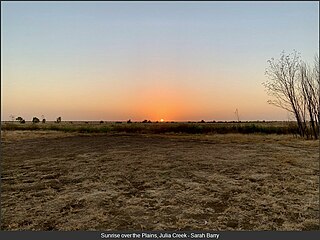
Julia Creek is an outback town and locality in the Shire of Mckinlay, Queensland, Australia. In the 2016 census, the locality of Julia Creek had a population of 511 people.

<span class="mw-page-title-main">Shire of Murweh</span> Local government area in Queensland, Australia

The Shire of Murweh is a local government area in the Maranoa district, which is part of South West Queensland, Australia. The administrative centre and largest town in the shire is Charleville. In June 2018, the Shire of Murweh had a population of 4,318.

<span class="mw-page-title-main">Shire of Winton</span> Local government area in Queensland, Australia

The Shire of Winton is a local government area in Central West Queensland, Australia. It covers an area of 53,814 square kilometres (20,777.7 sq mi), and has existed as a local government entity since 1887. Its administrative centre is located in the town of Winton. It is named after Winton, Dorset, England, the birthplace of Robert Allen, the first white settler in the Winton (Queensland) area.

<span class="mw-page-title-main">Shire of Diamantina</span> Local government area in Queensland, Australia

The Shire of Diamantina is a local government area in Central West Queensland, bordering South Australia and the Northern Territory. Its administrative centre is in the town of Bedourie.

<span class="mw-page-title-main">Shire of Cloncurry</span> Local government area in Queensland, Australia

The Shire of Cloncurry is a local government area in North West Queensland, Australia. It covers an area of 47,971 square kilometres (18,521.7 sq mi), and has existed as a local government entity since 1884. The major town and administrative centre of the shire is Cloncurry.

<span class="mw-page-title-main">Shire of Richmond</span> Local government area in Queensland, Australia

The Shire of Richmond is a local government area in north western Queensland, Australia.

<span class="mw-page-title-main">Shire of Croydon</span> Local government area in Queensland, Australia

The Shire of Croydon is a local government area in western Queensland, Australia. The shire, administered from the town of Croydon, covers an area of 29,498 square kilometres (11,389.2 sq mi). The council consists of a mayor plus four councillors, each of whom represents the entire Shire.

<span class="mw-page-title-main">Aboriginal Shire of Palm Island</span> Local government area in Queensland, Australia

The Aboriginal Shire of Palm Island is a special local government area of Queensland, Australia, managed by the Palm Island Aboriginal Shire Council under a Deed of Grant in Trust granted to the community on 27 October 1986. The local council was previously the Palm Island Community Council, which had far fewer powers. The shire is located on the Palm Island group, off the north Queensland coast near the city of Townsville.

<span class="mw-page-title-main">North Burnett Region</span> Local government area in Queensland, Australia

The North Burnett Region is a local government area in Queensland, Australia in the northern catchment of the Burnett River. Established in 2008, it was preceded by several previous local government areas with histories extending back to the early 1900s.

<span class="mw-page-title-main">Isaac Region</span> Local government area in Queensland, Australia

The Isaac Region is a local government area located in Central Queensland, Queensland, Australia created in March 2008 as a result of the report of the Local Government Reform Commission released in July 2007.

<span class="mw-page-title-main">Cassowary Coast Region</span> Local government area in Queensland, Australia

The Cassowary Coast Region is a local government area in the Far North Queensland region of Queensland, Australia, south of Cairns and centred on the towns of Innisfail, Cardwell and Tully. It was created in 2008 from a merger of the Shire of Cardwell and the Shire of Johnstone.

<span class="mw-page-title-main">Aboriginal Shire of Kowanyama</span> Local government area in Queensland, Australia

The Aboriginal Shire of Kowanyama is a special local government area which is located on western Cape York Peninsula in Queensland, Australia. It is managed under a Deed of Grant in Trust under the Local Government Act 2004.

<span class="mw-page-title-main">Aboriginal Shire of Pormpuraaw</span> Local government area in Queensland, Australia

The Aboriginal Shire of Pormpuraaw is a special local government area which is located on western Cape York Peninsula in Queensland, Australia. It is managed under a Deed of Grant in Trust under the Local Government Act 2004.

<span class="mw-page-title-main">Aboriginal Shire of Yarrabah</span> Local government area in Queensland, Australia

The Aboriginal Shire of Yarrabah is a special local government area in Far North Queensland, Queensland, Australia, east and southeast of Cairns on Cape Grafton. It is managed under a Deed of Grant in Trust under the Local Government Act 2004.

Kynuna is an outback town in the Shire of McKinlay and a locality split between the Shire of McKinlay and the Shire of Winton in Queensland, Australia. In the 2016 census the locality of Kynuna had a population of 55 people.

<span class="mw-page-title-main">McKinlay, Queensland</span> Town in Queensland, Australia

McKinlay is an outback town and locality in McKinlay Shire, Queensland, Australia. In the 2016 census, the locality of McKinlay had a population of 178 people.

<span class="mw-page-title-main">Aboriginal Shire of Hope Vale</span> Local government area in Queensland, Australia

The Aboriginal Shire of Hope Vale is a local government area in Far North Queensland, Queensland, Australia, north of the town of Cooktown. The majority of the Shire consists of Deed of Grant land that is held for the benefit of Aboriginal people particularly concerned with the land and their ancestors and descendants.

References

  1. 1 2 "3218.0 – Regional Population Growth, Australia, 2017-18: Population Estimates by Local Government Area (ASGS 2018), 2017 to 2018". Australian Bureau of Statistics. Australian Bureau of Statistics. 27 March 2019. Retrieved 25 October 2019. Estimated resident population, 30 June 2018.
  2. CC BY icon-80x15.png This Wikipedia article incorporates CC-BY-4.0 licensed text from: "Wanamarra". Queensland Aboriginal and Torres Strait Islander languages map. State Library of Queensland . Retrieved 5 February 2020.
  3. "McKinlay Shire". Queensland Places. Centre for the Government of Queensland, University of Queensland. Retrieved 18 September 2013.
  4. "McKinlay Shire Council". Public Libraries Connect. State Library of Queensland. 20 September 2017. Archived from the original on 5 February 2018. Retrieved 6 February 2018.
  5. "2008 McKinlay Shire - Mayoral Election - Election Summary". results.ecq.qld.gov.au. Retrieved 4 December 2017.
  6. "2012 McKinlay Shire - Mayoral Election - Election Summary". results.ecq.qld.gov.au. Retrieved 4 December 2017.
  7. "2016 McKinlay Shire Council - Mayoral Election - Election Summary". results.ecq.qld.gov.au. Retrieved 4 December 2017.
  8. "2020 Local Government Elections: Saturday, 28 March 2020". Electoral Commission of Queensland. 2020. Retrieved 16 June 2020.[ dead link ]

Coordinates: 20°39′24″S141°44′44″E / 20.65667°S 141.74556°E / -20.65667; 141.74556