Degilbo

Last updated

Map all coordinates using: OpenStreetMap  
Download coordinates as: KML
Degilbo
Queensland
DegilboWarMemorial.JPG
War memorial
Australia Queensland location map.svg
Red pog.svg
Degilbo
Coordinates 25°28′58″S151°59′58″E / 25.4827°S 151.9994°E / -25.4827; 151.9994 (Degilbo (town centre)) Coordinates: 25°28′58″S151°59′58″E / 25.4827°S 151.9994°E / -25.4827; 151.9994 (Degilbo (town centre))
Population174 (2016 census) [1]
 • Density1.855/km2 (4.804/sq mi)
Postcode(s) 4621
Area93.8 km2 (36.2 sq mi)
Time zone AEST (UTC+10:00)
Location
LGA(s) North Burnett Region
State electorate(s) Callide
Federal division(s) Flynn
Localities around Degilbo:
Didcot Coringa Dallarnil
Didcot Degilbo Woowoonga
Biggenden Biggenden Biggenden

Degilbo is a rural town and locality in the North Burnett Region, Queensland, Australia. [2] [3] In the 2016 census, the locality of Degilbo had a population of 174 people. [1]

Contents

History

The name Degilbo was the name of a pastoral run owned by William Henry Walsh (a Member of the Queensland Legislative Council) in 1847. It is believed to be an Aboriginal word dackeel bo meaning sharp or upright stones. [4] A very popular story is that Degilbo is actually the word obliged spelt backwards, attributed to a railway surveyor, who had to assign names to many railway stations, had run out of ideas but as he was obliged to come up with a name, he wrote that word down backwards. [5] Being perhaps a more entertaining story, the story of the backwards spelling is frequently published, and is usually followed by a spate of correspondence pointing out that the name of the pastoral run preceded the railway station by at least 20 years. [6] [7]

The first Degilbo Post Office opened on 1 April 1893. It was renamed Woowoonga in 1894, Appallan in 1897 and Degilbo in 1898. It closed in 1958. [8]

Woowoonga Provisional School opened on 15 March 1894. In 1898 it was renamed Degilbo Provisional School and in January 1908 it became Degilbo State School. With only 11 students enrolled at at November 2007, the school was mothballed on 31 December 2007 before final closure on 5 June 2008. [9] [10] [11] It was at 598 Gooroolba Road ( 25°28′58″S151°59′50″E / 25.4829°S 151.9971°E / -25.4829; 151.9971 (Degilbo State School (former)) ). [12] [13] The school's website was archived. [14]

Woowoonga Creek Provisional School on 17 January 1898 and became Woowoonga Creek State School on 1 January 1909 only to close that same year. [9] The school was just south of Woowoonga Creek ( 25°27′40″S152°02′41″E / 25.4612°S 152.0448°E / -25.4612; 152.0448 (Woowoonga Creek State School (former)) ). [15] [16]

Mount Appallan Provisional School opened on 4 August 1902. On 1 January 1909, it became Mount Appallan State School. It closed in 1953. [9] It was at 33 Cheese Factory Road ( 25°26′15″S152°00′09″E / 25.4376°S 152.0024°E / -25.4376; 152.0024 (Mount Appallan State School (former)) ). [17] [18] [16] It was named after Mount Appallan ( 25°25′04″S152°00′12″E / 25.4179°S 152.0034°E / -25.4179; 152.0034 (Mount Appallan) ). [17] [16]

The Degilbo War Memorial was unveiled on Sunday 17 September 1922. It commemorates those who served and died in World War I. [19] It is located beside the Isis Highway ( 25°29′06″S152°00′04″E / 25.48502°S 152.00108°E / -25.48502; 152.00108 (Degilbo War Memorial) ). [20]

The Bicentennial National Trail passes Degilbo. [21]

At the 2011 census, the locality of Degilbo had a population of 338. [22]

In the 2016 census, the locality of Degilbo had a population of 174 people. [1]

Heritage listings

Degilbo has a number of heritage-listed sites, including:

The Official Register of Engineering Heritage Markers listed

Education

There are no schools in Degilbo. The nearest primary schools are in Biggenden and Dallarnil while the nearest secondary schools are in Biggenden (to Year 10) and in Gayndah and Childers (both to Year 12). [16]

Related Research Articles

<span class="mw-page-title-main">Mundubbera</span> Town in Queensland, Australia

Mundubbera is a town and a locality in the North Burnett Region, Queensland, Australia. In the 2016 census, Mundubbera had a population of 1261 people.

<span class="mw-page-title-main">Biggenden</span> Town in Queensland, Australia

Biggenden is a rural town and locality in the North Burnett Region, Queensland, Australia. In the 2016 census, Biggenden had a population of 845 people.

<span class="mw-page-title-main">Shire of Biggenden</span> Local government area in Queensland, Australia

The Shire of Biggenden was a local government area located in the northern catchment of the Burnett River, Queensland, Australia, 100 kilometres (62 mi) south-southwest of the regional city of Bundaberg. The shire covered an area of 1,314.5 square kilometres (507.5 sq mi), and existed as a local government area from 1905 until 2008, when it amalgamated with several other shires to become the North Burnett Region.

<span class="mw-page-title-main">North Burnett Region</span> Local government area in Queensland, Australia

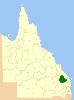
The North Burnett Region is a local government area in Queensland, Australia in the northern catchment of the Burnett River. Established in 2008, it was preceded by several previous local government areas with histories extending back to the early 1900s.

<span class="mw-page-title-main">Mungar Junction to Monto railway line</span> Former railway line in Queensland, Australia

The Mungar Junction to Monto railway line is a 267-kilometre (166 mi) railway in Queensland, Australia. Progressively opened in eleven stages between 1889 and 1928 the line branched from the North Coast line at Mungar Junction a short distance west of Maryborough and followed a westerly route towards Biggenden and Gayndah before turning north via Mundubbera and Eidsvold to Monto. It is also known as the Gayndah Monto Branch Railway.

<span class="mw-page-title-main">Ideraway</span> Town in Queensland, Australia

Ideraway is a rural town and locality in the North Burnett Region, Queensland, Australia. In the 2016 census, the locality of Ideraway had a population of 38 people.

Sharon is a rural locality in the Bundaberg Region, Queensland, Australia. In the 2016 census, Sharon had a population of 1,316 people.

<span class="mw-page-title-main">Didcot, Queensland</span> Suburb of North Burnett Region, Queensland, Australia

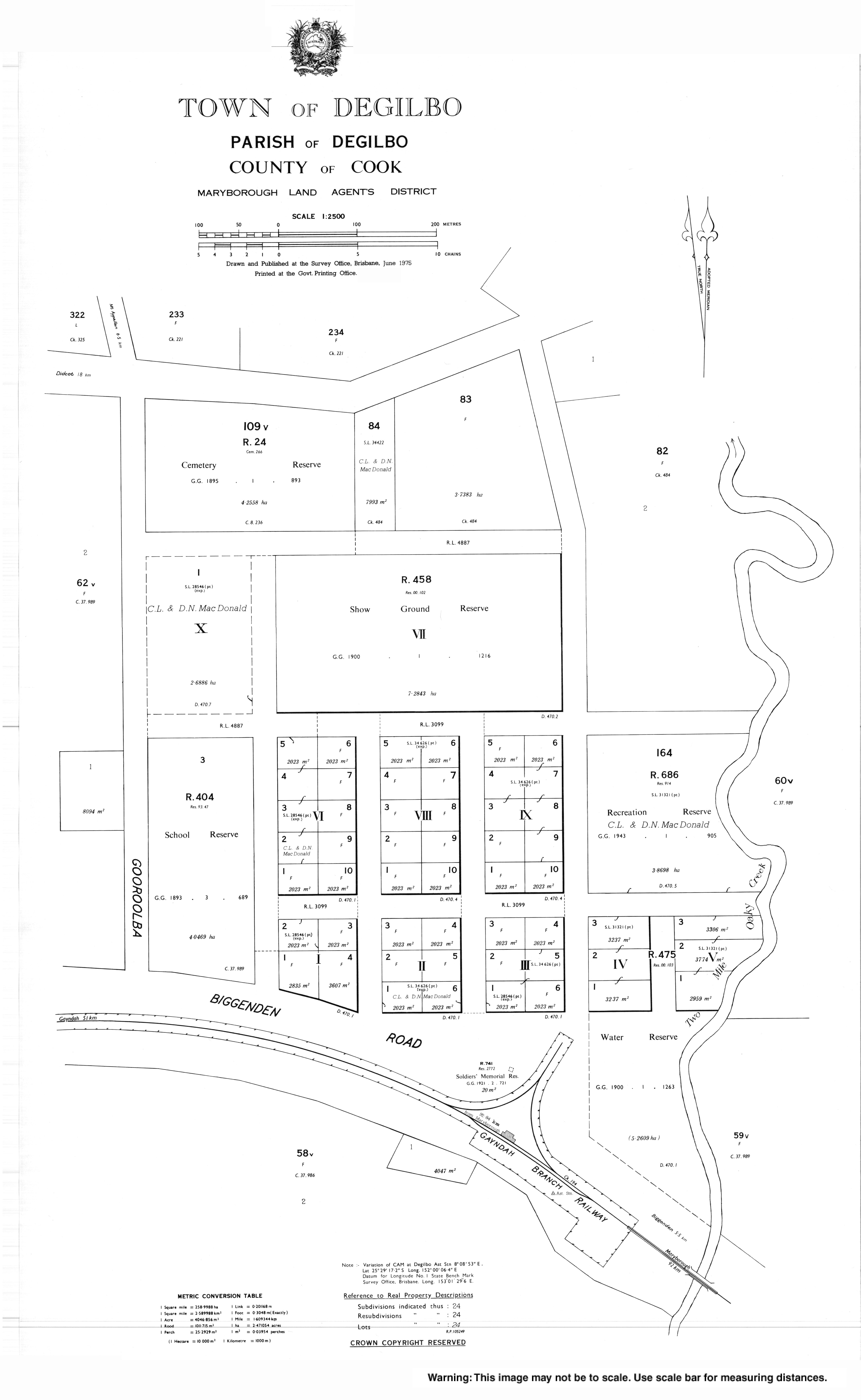
Didcot is a rural locality in the North Burnett Region, Queensland, Australia. In the 2016 census Didcot had a population of 60 people.

<span class="mw-page-title-main">Deep Creek Railway Bridge</span> Historic site in Queensland, Australia

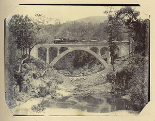
Deep Creek Railway Bridge is also known as Chowey Bridge. It is a heritage-listed railway bridge on the Mungar-Monto railway line in Didcot, North Burnett Region, Queensland, Australia. It was built in 1905 by day labour. It was added to the Queensland Heritage Register on 21 October 1992.

<span class="mw-page-title-main">William Pagan (railway engineer)</span> Australian railway engineer

William Pagan (1849–1924) was a railway engineer in Queensland, Australia. He designed many railway bridges, some of which are now heritage-listed.

<span class="mw-page-title-main">Steep Rocky Creek Railway Bridge</span> Railway bridge in Queensland, Australia.

Steep Rocky Creek Railway Bridge is a heritage-listed railway bridge on the Mungar - Monto railway line at Ideraway in the North Burnett Region of Queensland, Australia. It was designed by William Pagan and built from 1906 to 1907. It was added to the Queensland Heritage Register on 21 October 1992.

<span class="mw-page-title-main">Humphery Railway Bridge</span> Historic site in Queensland, Australia

Humphery Railway Bridge is a heritage-listed railway bridge on the Mungar to Monto railway line at Humphery, North Burnett Region, Queensland, Australia. It was designed by William Pagan and built in 1913. It was added to the Queensland Heritage Register on 21 October 1992.

Coringa is a rural locality in the North Burnett Region, Queensland, Australia. In the 2016 census, Coringa had a population of 77 people.

Lakeside is a rural locality in the North Burnett Region, Queensland, Australia. In the 2016 census Lakeside had a population of 55 people.

Dirnbir is a rural locality in the North Burnett Region, Queensland, Australia. In the 2016 census, Dirnbir had a population of 49 people.

Golden Fleece is a locality in the North Burnett Region, Queensland, Australia. In the 2016 census, Golden Fleece had a population of 49 people.

Woowoonga is a locality in the North Burnett Region, Queensland, Australia. In the 2016 census, Woowoonga had a population of 92 people.

Mount Lawless is a rural locality in the North Burnett Region, Queensland, Australia. In the 2016 census, Mount Lawless had a population of 12 people.

Maryborough–Biggenden Road is an 83.4 kilometres (51.8 mi) road route in the Fraser Coast and North Burnett regions of Queensland, Australia. The entire route is signed as State Route 86.

The Boyne Burnett Inland Rail Trail is a recreational route for walkers, cyclists and horse riders from Taragoola to Gayndah. It uses the closed Gladstone to Monto and Mungar Junction to Monto railway corridors in Queensland, Australia.

References

  1. 1 2 3 Australian Bureau of Statistics (27 June 2017). "Degilbo (SSC)". 2016 Census QuickStats. Retrieved 20 October 2018. OOjs UI icon edit-ltr-progressive.svg
  2. "Degilbo – town in North Burnett Region (entry 9673)". Queensland Place Names. Queensland Government . Retrieved 7 March 2022.
  3. "Degilbo – locality in North Burnett Region (entry 45340)". Queensland Place Names. Queensland Government . Retrieved 7 March 2022.
  4. "Degilbo (entry 9673)". Queensland Place Names. Queensland Government . Retrieved 13 September 2015.
  5. "Letters to the Editor". The Courier-Mail . Brisbane: National Library of Australia. 30 October 1935. p. 21. Archived from the original on 14 April 2022. Retrieved 12 July 2013.
  6. "ABORIGINAL NAMES". The Sydney Morning Herald . National Library of Australia. 11 March 1922. p. 15. Archived from the original on 14 April 2022. Retrieved 12 July 2013.
  7. "MEANING OF DEGILBO". The Brisbane Courier . National Library of Australia. 15 December 1930. p. 3. Archived from the original on 14 April 2022. Retrieved 12 July 2013.
  8. Phoenix Auctions History. "Post Office List". Phoenix Auctions. Archived from the original on 14 April 2022. Retrieved 20 February 2021.
  9. 1 2 3 Queensland Family History Society (2010), Queensland schools past and present (Version 1.01 ed.), Queensland Family History Society, ISBN   978-1-921171-26-0
  10. "Queensland state school - centre closures" (PDF). Queensland Government . 20 August 2013. Archived (PDF) from the original on 20 March 2022. Retrieved 6 April 2022.
  11. "Degilbo school to close doors". ABC News . 22 November 2007. Archived from the original on 29 October 2016. Retrieved 14 April 2022.
  12. "9247-22 Mount Shamrock" (Map). Queensland Government. 2008. Archived from the original on 14 April 2022. Retrieved 14 April 2022.
  13. "9247 Mount Perry" (Map). Queensland Government. 1977. Archived from the original on 14 April 2022. Retrieved 14 April 2022.
  14. "Home page". Degilbo State School. 18 July 2008. Archived from the original on 18 July 2008. Retrieved 14 April 2022.
  15. "Parish of Woowoonga" (Map). Queensland Government. 1900. Archived from the original on 12 January 2021. Retrieved 10 January 2021.
  16. 1 2 3 4 "Queensland Globe". State of Queensland . Retrieved 14 April 2022.
  17. 1 2 "Dallarnil" (Map). Queensland Government. 1942. Archived from the original on 14 April 2022. Retrieved 14 April 2022.
  18. "Queensland Two Mile series sheet 2m115" (Map). Queensland Government. 1951. Archived from the original on 14 April 2022. Retrieved 14 April 2022.
  19. "WAR MEMORIAL UNVEILING". Maryborough Chronicle, Wide Bay And Burnett Advertiser . No. 14, 699. Queensland, Australia. 22 September 1922. p. 3. Archived from the original on 14 April 2022. Retrieved 14 April 2022 via National Library of Australia.
  20. "Degiblo War Memorial". Monument Australia. Archived from the original on 7 April 2014. Retrieved 5 April 2014.
  21. Council, North Burnett Regional. "Bicentennial Trail". North Burnett Regional Council . Retrieved 13 October 2022.
  22. Australian Bureau of Statistics (31 October 2012). "Degilbo (SSC)". 2011 Census QuickStats. Retrieved 12 July 2013. OOjs UI icon edit-ltr-progressive.svg
  23. "Deep Creek Railway Bridge, Chowey (entry 600031)". Queensland Heritage Register . Queensland Heritage Council. Retrieved 12 July 2013.
  24. 1 2 3 "North Burnett Local Heritage Register" (PDF). North Burnett Regional Council. Archived (PDF) from the original on 16 August 2019. Retrieved 16 August 2019.
  25. McLachlan, Mark (6 June 2018). "Degilbo to Mundubbera Railway Bridges, 1905 to 1914". Boyne Burnett Inland Rail Trail. Retrieved 25 September 2022.
  26. McGrath, PSM, B. L.; Churchward, Alan (October 2015). "Nomination of the Gayndah Rail Bridges, Queensland for ENGINEERING HERITAGE RECOGNITION under Engineering Heritage Australia's Engineering Heritage Recognition Program" (PDF). Engineers Australia . Retrieved 26 September 2022.