Everton Hills, Queensland

Last updated

Everton Hills
Moreton Bay,  Queensland
Bowman Park, Everton Hills.jpg
Bowman Park, Everton Hills
Australia Queensland location map.svg
Red pog.svg
Everton Hills
Everton Hills, Queensland
Coordinates 27°23′26″S152°58′21″E / 27.3905°S 152.9725°E / -27.3905; 152.9725 (Everton Hills (centre of suburb))
Population5,938 (2016 census) [1]
 • Density1,799/km2 (4,660/sq mi)
Postcode(s) 4053
Area3.3 km2 (1.3 sq mi)
Time zone AEST (UTC+10:00)
Location
LGA(s) City of Moreton Bay
State electorate(s) Everton
Federal division(s) Dickson
Suburbs around Everton Hills:
Bunya Bunya McDowall
Arana Hills Everton Hills Everton Park
Keperra Mitchelton Everton Park

Everton Hills is a suburb in the City of Moreton Bay, Queensland, Australia. [2] In the 2016 census, Everton Hills had a population of 5,938 people. [1]

Contents

Geography

Located in the north-west of the Brisbane metropolitan area, the suburb extends northwest from Everton Park; this separation of suburbs is marked by a park called 'Boundary Park'. Everton Hills' southern boundary runs along the Kedron Brook, separating it from Mitchelton. It is also located at the edge of the Bunyaville Forest Reserve. Informally it is part of the Hills District. [3]

History

Everton Hills is situated in the Yugarabul traditional Indigenous Australian country. [4]

Everton Hills takes its name from its neighbouring suburb Everton Park which in turn was named after the residence of pioneer settler Ambrose McDowall, who named his residence after Everton, a suburb in Liverpool, England. [2]

In the 1890s, the town of Bunyaville ( 27°23′25″S152°58′38″E / 27.3903°S 152.9772°E / -27.3903; 152.9772 (Bunyaville (formerly Kedron)) ) was located north of South Pine Road in the present-day suburbs of Everton Hills and Everton Park. [5] [6] Until 1891, it was known as Kedron after Kedron Brook which flows through the area. [7] [8]

Bunyaville Baptist Church opened on Saturday 2 July 1932. It was on Timms Road (now in Everton Hills) on land donated by Arthur Timms with some financial assistance from the Newmarket Baptist Church. It was built "in a day" on Saturday 4 June 1932. [9] [10] [11] [12] [13] [14] [15] [16] Later, [ when? ] it became known as the Everton Hills Baptist Church. Subsequently,[ when? ] the former baptist church building was relocated to the Hills Church at 79 Queens Road ( 27°23′12″S152°58′55″E / 27.3866°S 152.9820°E / -27.3866; 152.9820 (Former Bunyaville / Everton Hills Baptist Church building) ). [17]

Prince of Peace Lutheran College opened on 3 January 1984. [18] The Prince of Peace Lutheran Church opened adjacent to the school in 1986, having been previously located in Maundrell Terrace, Chermside West. [19]

Until 2008, Everton Hills was in the Pine Rivers Shire, when amalgamated into the Moreton Bay Region, now known as the City of Moreton Bay. [20]

Demographics

In the 2011 census, Everton Hills recorded a population of 5,812 people, 50.7% female and 49.3% male. [21] The median age of the Everton Hills population was 35 years, 2 years below the national median of 37. 81.5% of people living in Everton Hills were born in Australia. The other top responses for country of birth were England 3.5%, New Zealand 2.9%, Scotland 0.8%, Philippines 0.8%, South Africa 0.8%. 91.7% of people spoke only English at home; the next most common languages were 0.6% German, 0.4% Japanese, 0.4% Italian, 0.3% Afrikaans, 0.3% Vietnamese. [21]

In the 2016 census, Everton Hills had a population of 5,938 people. [1]

In the 2021 census, Everton Hills' population had grown to 6,673 people. [22]

Education

Prince of Peace Lutheran College is a secondary (7-12) campus for boys and girls of the Prince of Peace Lutheran College at 25 Henderson Road ( 27°23′24″S152°57′58″E / 27.3900°S 152.9662°E / -27.3900; 152.9662 (Prince of Peace Lutheran College) ). [23] [24] The school's primary campus is in Everton Park. In 2018, the school had an enrolment of 752 students with 57 teachers (50 full-time equivalent) and 66 non-teaching staff (31 full-time equivalent). [25]

There are no government schools in Everton Hills. The nearest government primary schools are McDowall State School in neighbouring McDowall to the north-east, Grovely State School in neighbouring Keperra to the south-west, and Everton Park State School in neighbouring Everton Park to the south-east. The nearest government secondary schools are Mitchelton State High School in neighbouring Mitchelton to the south, Everton Park State High School in neighbouring Everton Park to the south-east and Albany Creek State High School in Albany Creek to the north. [6]

Amenities

Everton Hills contains numerous hardware and automotive services, which include hardware, glaziers, landscapers, mechanics and smash repairs. The area's major shopping centre, Brookside Shopping Centre, is in the adjacent suburb Mitchelton, but here are also two convenience centres in Everton Hills; one in Camelia Avenue and another on Queens Road. [26]

Hills Church is at 79 Queens Road ( 27°23′12″S152°58′55″E / 27.3867°S 152.9819°E / -27.3867; 152.9819 (Hills Church) ). [27] It is part of the Wesleyan Methodist Church. [28]

The Prince of Peace Lutheran Church is at 20 Rogers Parade West, adjacent to the Prince of Peace Lutheran School campus ( 27°23′30″S152°58′42″E / 27.3917°S 152.9782°E / -27.3917; 152.9782 (Prince of Peace Lutheran Church) ). [29] [30]

The suburb is home to the Hills District PCYC. [31]

Political representatives

Tim Mander is the current sitting member of the Legislative Assembly of Queensland for Everton, having been elected at the 2012 Queensland state election by defeating Labor's Murray Watt (the Parliamentary Secretary to the Treasurer). [32] Everton Hills is in the Federal Division of Dickson which Peter Dutton currently holds. [33] Everton Hills is in Division 10 of the Moreton Bay City Council, held since 2016 by Matt Constance. [34]

Related Research Articles

<span class="mw-page-title-main">Gordon Park, Queensland</span> Suburb of Brisbane, Queensland, Australia

Gordon Park is a northern suburb in the City of Brisbane, Queensland, Australia. In the 2021 census, Gordon Park had a population of 4,390 people.

<span class="mw-page-title-main">Scarborough, Queensland</span> Suburb of City of Moreton Bay, Queensland, Australia

Scarborough is a coastal suburb on the Redcliffe Peninsula in the City of Moreton Bay, Queensland, Australia. In the 2021 census, Scarborough had a population of 9,178 people.

<span class="mw-page-title-main">Mitchelton, Queensland</span> Suburb of Brisbane, Queensland, Australia

Mitchelton is a north-western suburb in the City of Brisbane, Queensland, Australia. In the 2016 census, Mitchelton had a population of 8,559 people.

<span class="mw-page-title-main">Caboolture, Queensland</span> Suburb of Brisbane, Queensland, Australia

Caboolture is a town and suburb in the City of Moreton Bay, Queensland, Australia. In the 2021 census, the suburb of Caboolture had a population of 29,534 people. It is located on the northern side of the Caboolture River.

<span class="mw-page-title-main">Chermside West, Queensland</span> Suburb of Brisbane, Queensland, Australia

Chermside West is a suburb in the City of Brisbane, Queensland, Australia. In the 2016 census, Chermside West had a population of 6,458 people. Parts of Chermside West were formerly known as Craigslea.

<span class="mw-page-title-main">Gatton, Queensland</span> Town in Queensland, Australia

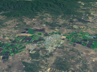
Gatton is a rural town and locality in the Lockyer Valley Region, Queensland, Australia. In the 2016 census, the locality of Gatton had a population of 7,101 people.

<span class="mw-page-title-main">Gaythorne, Queensland</span> Suburb of Brisbane, Queensland, Australia

Gaythorne is a suburb in the City of Brisbane, Queensland, Australia. In the 2016 census, Gaythorne had a population of 3,023 people.

<span class="mw-page-title-main">Stafford, Queensland</span> Suburb of Brisbane, Queensland, Australia

Stafford is a suburb in the City of Brisbane, Queensland, Australia. In the 2021 census, Stafford had a population of 6,561 people.

<span class="mw-page-title-main">Laidley, Queensland</span> Town in Queensland, Australia

Laidley is a rural town and locality in the Lockyer Valley Region, Queensland, Australia. In the 2016 census, the locality of Laidley had a population of 3,808 people.

<span class="mw-page-title-main">Albany Creek</span> Suburb of Moreton Bay, Queensland, Australia

Albany Creek is a southern suburb in the City of Moreton Bay, Queensland, Australia. In the 2021 census, Albany Creek had a population of 16,385.

<span class="mw-page-title-main">Strathpine, Queensland</span> Suburb of City of Moreton Bay, Queensland, Australia

Strathpine is a suburb in the City of Moreton Bay, Queensland, Australia. In the 2016 census, Strathpine had a population of 9,503 people. It is home to the Pine Rivers District offices of the City of Moreton Bay, as well as many businesses, administrative, and local, state and federal government offices. The area is home to Strathpine Centre, a medium-sized urban shopping centre, built by Westfield.

<span class="mw-page-title-main">Aratula</span> Town in Queensland, Australia

Aratula is a rural town and locality in the Scenic Rim Region, Queensland, Australia. In the 2016 census, the locality of Aratula had a population of 532 people.

<span class="mw-page-title-main">Keperra, Queensland</span> Suburb of Brisbane, Queensland, Australia

Keperra is a suburb in the City of Brisbane, Queensland, Australia. In the 2016 census, Keperra had a population of 6,807 people.

<span class="mw-page-title-main">Everton Park, Queensland</span> Suburb of Brisbane, Queensland, Australia

Everton Park is a suburb of the City of Brisbane, Queensland, Australia. In the 2016 census, Everton Park had a population of 8,862 people.

<span class="mw-page-title-main">Grange, Queensland</span> Suburb of Brisbane, Queensland, Australia

Grange is a northern suburb in the City of Brisbane, Queensland, Australia. In the 2016 census, Grange had a population of 4,318 people.

<span class="mw-page-title-main">Enoggera, Queensland</span> Suburb of Brisbane, Queensland, Australia

Enoggera is a north-western suburb in the City of Brisbane, Queensland, Australia. It is home to the Gallipoli Barracks.

<span class="mw-page-title-main">Arana Hills, Queensland</span> Suburb of Moreton Bay, Queensland, Australia

Arana Hills is a suburb in Division 10 of the City of Moreton Bay, Queensland, Australia. In the 2016 census, Arana Hills had a population of 6,810 people.

Bunya is a suburb in the City of Moreton Bay, Queensland, Australia. In the 2016 census, Bunya had a population of 1,916 people.

<span class="mw-page-title-main">Ropeley, Queensland</span> Suburb of Lockyer Valley Region, Queensland, Australia

Ropeley is a rural locality in the Lockyer Valley Region, Queensland, Australia. In the 2016 census Ropeley had a population of 194 people.

Urraween is a suburb of Hervey Bay in the Fraser Coast Region, Queensland, Australia. At the 2021 census Urraween had a population of 7,951.

References

  1. 1 2 3 Australian Bureau of Statistics (27 June 2017). "Everton Hills (SSC)". 2016 Census QuickStats. Retrieved 20 October 2018. OOjs UI icon edit-ltr-progressive.svg
  2. 1 2 "Everton Hills – suburb in Moreton Bay Region (entry 49593)". Queensland Place Names. Queensland Government . Retrieved 20 July 2021.
  3. "Everton Hills". Moreton Daily. Archived from the original on 20 September 2021. Retrieved 20 September 2021.
  4. "AIATSIS code E66: Yugarabul". Federal government. Australian Institute of Aboriginal and Torres Strait Islander Studies. 26 July 2019. Archived from the original on 13 August 2020. Retrieved 31 July 2020.
  5. "Moreton 40 Chain map AG2 series sheet 3 north" (Map). Queensland Government. 1892. Archived from the original on 3 December 2021. Retrieved 4 December 2021.
  6. 1 2 "Queensland Globe". State of Queensland . Retrieved 14 December 2021.
  7. "Bunyaville – population centre in City of Brisbane (entry 5308)". Queensland Place Names. Queensland Government . Retrieved 4 December 2021.
  8. "Nundah Divisional Board". The Telegraph . No. 5, 735. Queensland, Australia. 4 March 1891. p. 4. Retrieved 4 December 2021 via National Library of Australia.
  9. "IN ONE DAY". Sunday Mail . No. 471. Queensland, Australia. 5 June 1932. p. 19. Archived from the original on 14 December 2021. Retrieved 4 December 2021 via National Library of Australia.
  10. "Queensland Baptist churches by date of erection/opening". Baptist Church Archives Queensland. Archived from the original on 26 November 2021. Retrieved 29 November 2021.
  11. "1932 Bunyaville". Baptist Church Archives Queensland. Archived from the original on 26 November 2021. Retrieved 29 November 2021.
  12. "PULPIT AND PEOPLE". The Telegraph . Queensland, Australia. 25 June 1932. p. 17 (SPORTS FINAL). Archived from the original on 14 December 2021. Retrieved 4 December 2021 via National Library of Australia.
  13. "BUNYAVILLE MISSION". Sunday Mail . No. 475. Queensland, Australia. 3 July 1932. p. 5. Retrieved 4 December 2021 via National Library of Australia.
  14. "NEW BAPTIST CHURCH". The Brisbane Courier . No. 23, 222. Queensland, Australia. 4 July 1932. p. 12. Archived from the original on 14 December 2021. Retrieved 4 December 2021 via National Library of Australia.
  15. "Advertising". The Courier-mail . No. 1622. Queensland, Australia. 12 November 1938. p. 12 (Second Section.). Archived from the original on 14 December 2021. Retrieved 4 December 2021 via National Library of Australia.
  16. "BAPTIST". The Brisbane Courier . No. 23, 090. Queensland, Australia. 30 January 1932. p. 5. Retrieved 4 December 2021 via National Library of Australia.
  17. "Everton Hills Baptist Church - Former". Churches Australia. Archived from the original on 4 December 2021. Retrieved 4 December 2021.
  18. Queensland Family History Society (2010), Queensland schools past and present (Version 1.01 ed.), Queensland Family History Society, ISBN   978-1-921171-26-0
  19. "Community". Prince of Peace Lutheran College | Christian Private School, Brisbane North. Archived from the original on 4 December 2021. Retrieved 9 December 2021.
  20. "Settlement and federation". www.moretonbay.qld.gov.au. Archived from the original on 20 September 2021. Retrieved 20 September 2021.
  21. 1 2 "2011 Census QuickStats: Everton Hills". quickstats.censusdata.abs.gov.au. Archived from the original on 20 September 2021. Retrieved 20 September 2021.
  22. "2021 Everton Hills, Census All persons QuickStats". Australian Bureau of Statistics. Retrieved 23 November 2023.
  23. "State and non-state school details". Queensland Government. 9 July 2018. Archived from the original on 21 November 2018. Retrieved 21 November 2018.
  24. "Prince of Peace Lutheran College". Prince of Peace Lutheran College. Archived from the original on 8 December 2018. Retrieved 20 September 2021.
  25. "ACARA School Profile 2018". Australian Curriculum, Assessment and Reporting Authority. Archived from the original on 27 August 2020. Retrieved 28 January 2020.
  26. "Everton Hills". Moreton Daily. Archived from the original on 20 September 2021. Retrieved 20 September 2021.
  27. "Hills Church". Wesleyan Methodist Church Australia. Archived from the original on 19 March 2021. Retrieved 21 August 2021.
  28. "South Queensland". Wesleyan Methodist Church Australia. Archived from the original on 21 August 2021. Retrieved 21 August 2021.
  29. "Lutheran Church Everton Hills Prince Of Peace Congregation, Qld". Everton Hills Prince Of Peace Congregation, Qld. Archived from the original on 14 December 2021. Retrieved 9 December 2021.
  30. "Community". Prince of Peace Lutheran College | Christian Private School, Brisbane North. Archived from the original on 4 December 2021. Retrieved 9 December 2021.
  31. "PCYC Hills District". PCYC. Archived from the original on 20 September 2021. Retrieved 20 September 2021.
  32. Queensland, Electoral Commission of (1 July 2019). "Electoral Commission of Queensland". results.elections.qld.gov.au. Archived from the original on 14 December 2021. Retrieved 20 September 2021.
  33. "House of Representatives division information". Australian Electoral Commission. Archived from the original on 29 January 2021. Retrieved 20 September 2021.
  34. "Councillor Matthew Constance". www.moretonbay.qld.gov.au. Archived from the original on 20 September 2021. Retrieved 20 September 2021.