Lawnton, Queensland

Last updated

Lawnton
Moreton Bay,  Queensland
Lawntonqueensland.JPG
Newer shops in Lawnton
Australia Queensland location map.svg
Red pog.svg
Lawnton
Lawnton, Queensland
Coordinates 27°16′55″S152°58′57″E / 27.2819°S 152.9824°E / -27.2819; 152.9824 (Lawnton (centre of suburb))
Population5,658 (2016 census) [1]
 • Density658/km2 (1,704/sq mi)
Postcode(s) 4501
Area8.6 km2 (3.3 sq mi)
Time zone AEST (UTC+10:00)
Location
LGA(s) City of Moreton Bay
State electorate(s)
Federal division(s) Dickson
Suburbs around Lawnton:
Petrie Petrie Murrumba Downs
Joyner Lawnton Strathpine
Bray Park Strathpine Bald Hills

Lawnton is a suburb in the City of Moreton Bay, Queensland, Australia. [3] In the 2016 census, Lawnton had a population of 5,658 people. [1]

Contents

Geography

Lawnton is bounded on the north and north-east by the North Pine River, to the south-east by the South Pine River and Four Mile Creek. [4]

Brisbane–Woodford Road, concurrent with Gympie Road, passes through the centre of the suburb in a south-north direction. [4]

The Caboolture railway line (North Coast railway line) enters the suburb from the north (Petrie) and exits to the south (Strathpine) with the suburb served by Lawnton railway station ( 27°16′53″S152°58′51″E / 27.2815°S 152.9809°E / -27.2815; 152.9809 (Lawnton railway station) ). [5]

History

Portrait of Stephen Lawn (1836-1917) Portrait of Stephen Lawn 1836-1917 farmer blacksmith and wheelwright of the North Pine area the father of Lawnton.JPG
Portrait of Stephen Lawn (1836-1917)

The origin of the suburb name is from an early property owner, the blacksmith Stephen Lawn. The property was acquired by Queensland Rail and was named Lawnton. [6] [7]

On Saturday 25 August 1888, Lady Musgrave, wife of the Queensland Governor Anthony Musgrave laid the foundation stone for St Thomas’ Anglican church at North Pine (as the area was previously known). [8] It was located on the corner of Station Road and Todds Road ( 27°16′58″S152°58′54″E / 27.2828°S 152.9818°E / -27.2828; 152.9818 (St Thomas's Anglican Church (former)) ) [9] on land donated by Stephen Lawn and built by James Todd. The church was dedicated on St Thomas's Day 21 December 1888 by Reverend C.G. Robinson, Rural Dean of Brisbane. [10] [11] [12] [13] The pulpit from the Samsonvale Homestead was donated to the church by William Joyner. The church was last used in 1984. [14] Its altar rails were re-conditioned for re-use in the new St Faith's Anglican Church in Strathpine, while the altar and other furnishings from St Thomas's were used to create a St Thomas' Chapel within the new church. The old church was relocated to the Old Petrie Town open-air museum. [15] [16]

Lawnton State School opened in 1967. [17]

Pine Rivers Special School opened in April 1986. [18]

The area east of Gympie Road was previously known as Wyllie (named after Alexander James Wyllie) until September 1989 when the Queensland Government decided to incorporate it within the suburb of Lawnton. [6] [19] It was also the location of the World War II Petrie Airfield. [20]

In the 2011 census, Lawnton recorded a population of 5,356 people, 50.9% female and 49.1% male. The median age of the Lawnton population was 36 years, 1 year below the national median of 37. 78.3% of people living in Lawnton were born in Australia. The other top responses for country of birth were New Zealand 5.1%, England 4%, Philippines 1%, India 0.9%, South Africa 0.6%. 90.7% of people spoke only English at home; the next most common languages were 0.8% Hindi, 0.5% Tagalog, 0.3% Dutch, 0.3% Italian, 0.3% Spanish. [21]

In the 2016 census, Lawnton had a population of 5,658 people. [1]

Economy

The Lawnton industrial estate as well as retail and commerce establishments along Gympie Road provide local services and employment. Alluvial gravel and sand mining also occur in Lawnton. There have been recent industrial and retail developments in Lawnton.

Education

Lawnton State School is a government primary (Prep-6) school for boys and girls at Todds Road ( 27°16′54″S152°58′29″E / 27.2818°S 152.9747°E / -27.2818; 152.9747 (Lawnton State School) ). [22] [23] In 2018, the school had an enrolment of 553 students with 40 teachers (33 full-time equivalent) and 27 non-teaching staff (17 full-time equivalent). [24] It includes a special education program. [22]

Pine Rivers Special School is a special primary and secondary (Early Childhood-12) school for boys and girls at 10 Lawnton Pocket Road ( 27°16′58″S152°59′02″E / 27.2829°S 152.9839°E / -27.2829; 152.9839 (Pine Rivers Special School) ). [22] [25] In 2018, the school had an enrolment of 201 students with 58 teachers (49 full-time equivalent) and 62 non-teaching staff (41 full-time equivalent). [24]

YOS Lawnton is a private secondary (10-12) school for boys and girls at 27-29 Lawnton Pocket Road ( 27°16′59″S152°59′06″E / 27.2830°S 152.9851°E / -27.2830; 152.9851 (YOS Lawnton) ). [22] [26] In 2018, the school had an enrolment of 50 students with 5 teachers and 11 non-teaching staff (8 full-time equivalent). [24] This school is a Youth Outreach Service by the Salvation Army which aims to get students who have disengaged with schooling to re-engage. [26]

There is no mainstream secondary school in Lawnton. The nearest government secondary schools are Pine Rivers State High School in neighbouring Strathpine to the south and Bray Park State High School in neighbouring Bray Park to the south-west. [4]

Amenities

The Moreton Bay City Council operates a mobile library service which visits Barclay Park on Nightingale Drive. [27]

Lawnton cemetery, 2007 Lawnton cemetery, 2006.jpg
Lawnton cemetery, 2007

Leis Park has electric barbecues and a boat ramp into the North Pine River. Wyllie Park on the Lawnton / Petrie border also has electric barbecues.

Lawnton Cemetery (also known as Mary Bray Park) is located on Norfolk Avenue ( 27°16′36″S152°58′37″E / 27.2766°S 152.9770°E / -27.2766; 152.9770 (Lawnton Cemetery) ). [28]

Transport

Lawnton railway station provides access to regular Queensland Rail City network services to Brisbane, Cleveland, Ipswich, Beenleigh and Springfield Central, as well as Kippa-Ring.

Related Research Articles

<span class="mw-page-title-main">Lawnton railway station</span> Railway station in Queensland, Australia

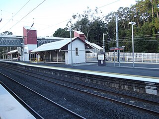
Lawnton railway station is located on the North Coast line in Queensland, Australia. It serves the suburb of Lawnton in the City of Moreton Bay.

<span class="mw-page-title-main">Petrie railway station</span> Railway station in Queensland, Australia

Petrie railway station is located on the North Coast line in Queensland, Australia. It serves the suburb of Petrie in the City of Moreton Bay. It opened as North Pine railway station in1888 after the nearby North Pine River and was renamed Petrie railway station in 1911.

<span class="mw-page-title-main">Bald Hills, Queensland</span> Suburb of Brisbane, Queensland, Australia

Bald Hills is the northernmost suburb in the City of Brisbane, Queensland, Australia. In the 2021 census, Bald Hills had a population of 7,000 people.

<span class="mw-page-title-main">Shire of Pine Rivers</span> Local government area in Queensland

The Shire of Pine Rivers was a local government area about 20 kilometres (12 mi) north of Brisbane in the Moreton Bay region of South East Queensland, Australia. The shire covered an area of 771 square kilometres (297.7 sq mi), and existed as a local government entity from 1888 until 2008, when it amalgamated with councils further north and east to form the Moreton Bay Region, renamed in July 2023 as the City of Moreton Bay.

<span class="mw-page-title-main">Petrie, Queensland</span> Suburb of Moreton Bay, Queensland, Australia

Petrie is a suburb in the City of Moreton Bay, Queensland, Australia. In the 2021 census, Petrie had a population of 8,722 people.

<span class="mw-page-title-main">Warner, Queensland</span> Suburb of City of Moreton Bay, Queensland, Australia

Warner is a suburb in the City of Moreton Bay, Queensland, Australia. In the 2016 census, Warner had a population of 11,411 people.

<span class="mw-page-title-main">South Pine River</span> River in Queensland, Australia

The South Pine River is a minor river in South East Queensland, Australia. It rises on the D'Aguilar Range and passes through the Samford Valley in the City of Moreton Bay local government area.

<span class="mw-page-title-main">Eatons Hill, Queensland</span> Suburb of City of Moreton Bay, Queensland, Australia

Eatons Hill is a suburb in the City of Moreton Bay, Queensland, Australia. In the 2016 census, Eatons Hill had a population of 7,973 people. Its postcode is 4037.

<span class="mw-page-title-main">Albany Creek</span> Suburb of Moreton Bay, Queensland, Australia

Albany Creek is a southern suburb in the City of Moreton Bay, Queensland, Australia. In the 2021 census, Albany Creek had a population of 16,385.

<span class="mw-page-title-main">Dayboro, Queensland</span> Town in Queensland, Australia

Dayboro is a rural town and locality in the City of Moreton Bay, Queensland, Australia. In the 2016 census, the locality of Dayboro had a population of 2,119 people.

<span class="mw-page-title-main">Strathpine, Queensland</span> Suburb of City of Moreton Bay, Queensland, Australia

Strathpine is a suburb in the City of Moreton Bay, Queensland, Australia. In the 2016 census, Strathpine had a population of 9,503 people. It is home to the Pine Rivers District offices of the City of Moreton Bay, as well as many businesses, administrative, and local, state and federal government offices. The area is home to Strathpine Centre, a medium-sized urban shopping centre, built by Westfield.

<span class="mw-page-title-main">Kallangur, Queensland</span> Suburb of Moreton Bay, Queensland, Australia

Kallangur is a suburb in the City of Moreton Bay, Queensland, Australia. In the 2016 census, Kallangur had a population of 20,405 people.

<span class="mw-page-title-main">Bray Park, Queensland</span> Suburb of Moreton Bay, Queensland, Australia

Bray Park is a suburb in the City of Moreton Bay, Queensland, Australia. In the 2016 census, Bray Park had a population of 10,246 people.

<span class="mw-page-title-main">Arana Hills, Queensland</span> Suburb of Moreton Bay, Queensland, Australia

Arana Hills is a suburb in Division 10 of the City of Moreton Bay, Queensland, Australia. In the 2016 census, Arana Hills had a population of 6,810 people.

<span class="mw-page-title-main">Everton Hills, Queensland</span> Suburb of Moreton Bay, Queensland, Australia

Everton Hills is a suburb in the City of Moreton Bay, Queensland, Australia. In the 2016 census, Everton Hills had a population of 5,938 people.

<span class="mw-page-title-main">North Pine River</span> River in Queensland, Australia

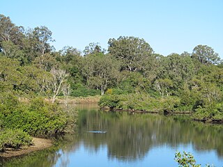
The North Pine River is a minor river in South East Queensland, Australia.

<span class="mw-page-title-main">Gympie Road</span> Road in Brisbane, Australia

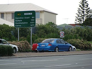
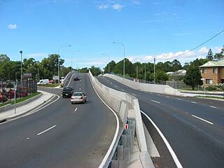
Gympie Road is a major road in the northern suburbs of Brisbane, Queensland, Australia. The road forms part of the main road route from the Brisbane Central Business District (CBD) to the northern suburbs, Sunshine Coast and east coast of Queensland.

<span class="mw-page-title-main">City of Moreton Bay</span> Local government area in Queensland, Australia

The City of Moreton Bay, known until July 2023 as the Moreton Bay Region, is a local government area in the north of the Brisbane metropolitan city in South East Queensland, Australia. Established in 2008, it replaced three established local government areas, the City of Redcliffe and the Shires of Pine Rivers and Caboolture.

Kurwongbah is a rural locality in the City of Moreton Bay, Queensland, Australia. In the 2016 census, Kurwongbah had a population of 1,430 people.

Brisbane–Woodford Road is the official name for a continuous 60.5-kilometre (37.6 mi) road route in the Moreton Bay local government area of Queensland, Australia. It is designated as part of State Route 58. It is a state-controlled road part regional and part district, rated as a local road of regional significance (LRRS).

References

  1. 1 2 3 Australian Bureau of Statistics (27 June 2017). "Lawnton (SSC)". 2016 Census QuickStats. Retrieved 20 October 2018. OOjs UI icon edit-ltr-progressive.svg
  2. Google (30 April 2024). "Brisbane CBD to Lawnton" (Map). Google Maps . Google. Retrieved 30 April 2024.
  3. "Lawnton – suburb in Moreton Bay Region (entry 45446)". Queensland Place Names. Queensland Government . Retrieved 20 July 2021.
  4. 1 2 3 "Queensland Globe". State of Queensland . Retrieved 22 December 2021.
  5. "Railway stations and sidings - Queensland". Queensland Open Data. Queensland Government. 2 October 2020. Archived from the original on 5 October 2020. Retrieved 5 October 2020.
  6. 1 2 "Lawnton (entry 45446)". Queensland Place Names. Queensland Government . Retrieved 27 July 2014.
  7. "Pine Rivers township history". Moreton Bay Regional Council. Archived from the original on 11 August 2014. Retrieved 3 July 2014.
  8. "St. Thomas's, North Pine". The Telegraph . No. 4, 954. Queensland, Australia. 27 August 1888. p. 5. Archived from the original on 22 December 2021. Retrieved 28 July 2020 via National Library of Australia.
  9. "Samford" (Map). Queensland Government. 1930. marked with a "+". Archived from the original on 17 September 2020. Retrieved 17 September 2020.
  10. "Epitome of news". The Brisbane Courier . Vol. XLV, no. 9, 653. Queensland, Australia. 21 December 1888. p. 4. Archived from the original on 22 December 2021. Retrieved 28 July 2020 via National Library of Australia.
  11. "The Brisbane Courier". The Brisbane Courier . Vol. XLV, no. 9, 653. Queensland, Australia. 21 December 1888. p. 4. Retrieved 28 July 2020 via National Library of Australia.
  12. "St. Thomas', North Pine". The Telegraph . No. 5, 056. Queensland, Australia. 26 December 1888. p. 2. Archived from the original on 22 December 2021. Retrieved 17 September 2020 via National Library of Australia.
  13. "General News". The Queenslander . Vol. XXXVI, no. 721. Queensland, Australia. 27 July 1889. p. 170. Archived from the original on 22 May 2021. Retrieved 22 May 2021 via National Library of Australia.
  14. "Closed Churches". Anglican Church of Southern Queensland. Archived from the original on 3 April 2019. Retrieved 3 April 2019.
  15. "Old Petrie Town - Buildings". oldpetrietown.com. Archived from the original on 17 September 2020. Retrieved 17 September 2020.
  16. "St Thomas' Anglican Church | Lawnton". Queensland Religious Places Database. Retrieved 27 April 2024.
  17. "Lawnton SS". Archived from the original on 4 February 2017. Retrieved 1 February 2017.
  18. "Opening and closing dates of Queensland Schools". Queensland Government . Retrieved 18 April 2019.
  19. "Item ID3411834, Queensland Place Names Act 1988 - Place Name for Omission. - Mr W.H. Glasson". Queensland State Archives . Retrieved 29 April 2021. — includes a map showing the boundaries of Wyllie
  20. "Place". Queensland WWII Historic Places. Queensland Government. 30 June 2014. Archived from the original on 28 June 2021. Retrieved 29 April 2021.
  21. "2011 Lawnton, Census All persons QuickStats | Australian Bureau of Statistics". www.abs.gov.au. Retrieved 3 August 2022.
  22. 1 2 3 4 "State and non-state school details". Queensland Government. 9 July 2018. Archived from the original on 21 November 2018. Retrieved 21 November 2018.
  23. "Lawnton State School". Archived from the original on 8 April 2020. Retrieved 21 November 2018.
  24. 1 2 3 "ACARA School Profile 2018". Australian Curriculum, Assessment and Reporting Authority. Archived from the original on 27 August 2020. Retrieved 28 January 2020.
  25. "Pine Rivers Special School". Archived from the original on 14 August 2020. Retrieved 21 November 2018.
  26. 1 2 "HOME". yoslawnton. Archived from the original on 18 May 2021. Retrieved 22 December 2021.
  27. "Mobile Library". Moreton Bay Regional Council . Archived from the original on 30 January 2018. Retrieved 30 January 2018.
  28. "Lawnton Cemetery". Moreton Bay Region . Archived from the original on 28 December 2021. Retrieved 6 January 2022.