Woorim, Queensland

Last updated

Woorim
Bribie Island,  Queensland
Woorim Beach, Queensland.jpg
Woorim Beach
Australia Queensland location map.svg
Red pog.svg
Woorim
Woorim, Queensland
Coordinates 27°04′12″S153°12′12″E / 27.0699°S 153.2034°E / -27.0699; 153.2034 (Woorim (town centre))
Population1,829 (2016 census) [1]
 • Density70.08/km2 (181.5/sq mi)
Postcode(s) 4507
Area26.1 km2 (10.1 sq mi)
Time zone AEST (UTC+10:00)
Location
LGA(s) City of Moreton Bay
State electorate(s) Pumicestone
Federal division(s) Longman
Suburbs around Woorim:
Banksia Beach Welsby Coral Sea
Bellara Woorim Coral Sea
Bongaree Moreton Bay Coral Sea

Woorim is a town and suburb of Bribie Island in the City of Moreton Bay, Queensland, Australia. [2] [3] In the 2016 census, Woorim had a population of 1,829 people. [1]

Contents

Geography

Woorim is on the south-eastern corner of Bribie Island, bounded by the Coral Sea to the east and Moreton Bay to the south. [4] Bald Point is on the southern beach ( 27°05′45″S153°11′42″E / 27.0959°S 153.1950°E / -27.0959; 153.1950 (Bald Point) ). [5]

Most of the north and west of the locality is within the Bribie Island National Park which extends into neighbouring Bongaree and Welsby. [4]

First Avenue connects Woorim to Bongaree and from there across the Bribie Island Bridge to the mainland. [4]

The Bribie Island Research Centre of the Queensland Department of Agriculture and Fisheries is an aquaculture research facility at 144 North Street ( 27°03′15″S153°11′43″E / 27.0543°S 153.1952°E / -27.0543; 153.1952 (Bribie Island Research Centre) ). [6]

Erosion of the beach at Woorim is an ongoing issue with long term recession trends of the shoreline observed. In September 2007 Caboolture Shire Council (now amalgamated into the Moreton Bay Regional Council) published a Shoreline Erosion Management Plan in response. [7] [8]

History

The name Woorim may be derived from the Kabi language word wurama meaning red backed sea eagle. [2]

The Bribie Island Fortifications were constructed from 1939 to 1943 as part of the systems of defence of southeast Queensland during the Second World War, and to provide artillery training for Australian soldiers for overseas service. Other fortifications were also apparent throughout Moreton Bay during the war, at Caloundra and on Moreton Island at Cowan Cowan Point and Rous, which together with the existing installations at Fort Lytton, provided a coordinated series of defensive batteries for the region. [9]

In the 2011 census, Woorim recorded a population of 1,765 people, 52.4% female and 47.6% male. [10] The median age of the Woorim population was 55 years, 18 years above the national median of 37. 70.5% of people living in Woorim were born in Australia. The other top responses for country of birth were England 6.3%, New Zealand 4.5%, Bhutan 1.1%, Netherlands 1.1%, Scotland 0.7%. 86.3% of people spoke only English at home; the next most common languages were 1.5% Nepali, 0.5% Greek, 0.4% Dutch, 0.2% Afrikaans, 0.2% German. [10]

In the 2016 census, Woorim had a population of 1,829 people, with a median age of 57 years. [1]

Heritage listings

Woorim has a number of heritage sites, including:

Education

There are no schools in Woorim. The nearest primary school is Bribie Island State School in neighbouring Bongaree to the south-west. The nearest secondary school is Bribie Island State High School in Bongaree. [4]

Amenities

Woorim has a beach, a small shopping centre, and parklands adjoining the beach.

Bribie Island Golf Club at 5 Links Court ( 27°04′56″S153°12′05″E / 27.0822°S 153.2013°E / -27.0822; 153.2013 (Bribie Island Golf Club) ) has an 18-hole par-72 course, a distance of 6,203 metres (20,351 ft). [12]

See also

Related Research Articles

<span class="mw-page-title-main">Bribie Island National Park</span> Protected area in Queensland, Australia

Bribie Island National Park is an Australian national park in the City of Moreton Bay, Queensland, 68 kilometres north of Brisbane. The park covers approximately one third of Bribie Island. The tidal wetlands and areas of water around the islands are protected within the Moreton Bay Marine Park.

<span class="mw-page-title-main">Bribie Island</span> Island in Queensland, Australia

Bribie Island is the smallest and most northerly of three major sand islands forming the coastline sheltering the northern part of Moreton Bay, Queensland, Australia. The others are Moreton Island and North Stradbroke Island. Bribie Island is 34 kilometres long, and 8 kilometres at its widest. Archibald Meston believed that the name of the island came from a corruption of a mainland word for it, Boorabee meaning koala. However, the correct Joondaburri name for the island is in fact Yarun.

<span class="mw-page-title-main">Caboolture, Queensland</span> Suburb of Brisbane, Queensland, Australia

Caboolture is a town and suburb in the City of Moreton Bay, Queensland, Australia. In the 2021 census, the suburb of Caboolture had a population of 29,534 people. It is located on the northern side of the Caboolture River.

Ningi is a town and locality in the City of Moreton Bay, Queensland, Australia. In the 2016 census, the locality of Ningi had a population of 4,675 people. It is near Caboolture.

<span class="mw-page-title-main">County of Canning</span> Cadastral in Queensland, Australia

The County of Canning is a county in Queensland, Australia. The county consists of almost all of the former Shires of Caboolture, Maroochy and Kilcoy and the former City of Caloundra. Its main urbanised areas are centred on the Sunshine Coast and the areas surrounding Caboolture.

<span class="mw-page-title-main">Deception Bay, Queensland</span> Suburb of Moreton Bay, Queensland, Australia

Deception Bay is a coastal suburb in the City of Moreton Bay, Queensland, Australia. In the 2016 census, Deception Bay had a population of 19,850 people.

Donnybrook is a coastal town and locality in the City of Moreton Bay, Queensland, Australia. In the 2016 census, the locality of Donnybrook had a population of 617 people.

<span class="mw-page-title-main">Banksia Beach, Queensland</span> Suburb of Bribie Island, Queensland, Australia

Banksia Beach is a town and suburb on Bribie Island in the City of Moreton Bay, Queensland, Australia. In the 2016 census the suburb of Banksia Beach had a population of 5,995 people.

<span class="mw-page-title-main">Beachmere, Queensland</span> Town in Queensland, Australia

Beachmere is a coastal rural town and locality in the City of Moreton Bay, Queensland, Australia. In the 2021 census, the locality of Beachmere had a population of 4,782 people.

<span class="mw-page-title-main">Pumicestone Channel</span> Strait in Queensland, Australia

Pumicestone Channel, also known as the Pumicestone Passage, is a narrow, mesotidal waterway around 45 kilometres in length, between Bribie Island and the mainland in Queensland, Australia. The northern extent of the passage is at Caloundra, while at the south is Deception Bay. The waterway is a two way tidal estuary that has 11 creeks flowing into it. At each end of the passage the channels are the deepest and widest.

Bellara is a suburb of Bribie Island in the City of Moreton Bay, Queensland, Australia. In the 2016 census, Bellara had a population of 3,225 people.

<span class="mw-page-title-main">Bongaree, Queensland</span> Suburb of Bribie Island, Queensland, Australia

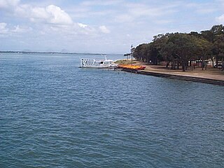
Bongaree is a suburb of Bribie Island in the City of Moreton Bay, Queensland, Australia. It is located on the western side of Bribie Island, adjacent to the Pumicestone Passage. In the 2016 census, Bongaree has a population of 6,947 people.

<span class="mw-page-title-main">Sandstone Point, Queensland</span> Suburb of City of Moreton Bay, Queensland, Australia

Sandstone Point is a coastal locality in the City of Moreton Bay, Queensland, Australia. In the 2016 census, Sandstone Point had a population of 3,959 people.

<span class="mw-page-title-main">Bribie Island Seaside Museum</span>

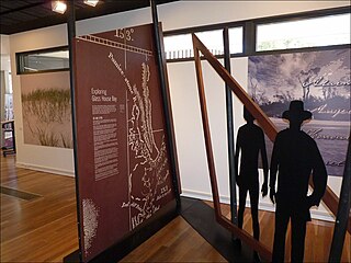
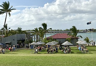
Bribie Island Seaside Museum opened on 14 May 2010 at 1 South Esplanade, Bongaree, on the Pumicestone Passage side of Bribie Island, City of Moreton Bay in Queensland, Australia. It is run by Moreton Bay City Council.

Meldale is a coastal rural locality in the City of Moreton Bay, Queensland, Australia. In the 2016 census, Meldale had a population of 223 people.

<span class="mw-page-title-main">White Patch, Queensland</span> Town in Queensland, Australia

White Patch is a coastal town and locality of Bribie Island in the City of Moreton Bay, Queensland, Australia. In the 2016 census the locality of White Patch had a population of 142 people.

<span class="mw-page-title-main">Welsby, Queensland</span> Suburb of Bribie Island, Queensland, Australia

Welsby is a coastal locality on Bribie Island in the City of Moreton Bay, Queensland, Australia. In the 2016 census Welsby had a population of 5 people.

<span class="mw-page-title-main">Bribie Island Second World War Fortifications</span> Historic site in Queensland, Australia

The Bribie Island Second World War Fortifications are heritage-listed fortifications at Woorim and Bribie Island North on Bribie Island, Queensland, Australia. They were built from 1939 to 1943 and were added to the Queensland Heritage Register on 20 July 1993.

<span class="mw-page-title-main">Bribie Island North</span> Suburb of Sunshine Coast Region, Queensland, Australia

Bribie Island North is a locality on Bribie Island in the Sunshine Coast Region, Queensland, Australia. In the 2016 census, Bribie Island North had a population of 0 people.

Caboolture–Bribie Island Road is a continuous 19.2 kilometres (11.9 mi) road route in the City of Moreton Bay, Queensland, Australia. The route is designated as part of State Route 85. It is a state-controlled district road rated as a local road of regional significance (LRRS).

References

  1. 1 2 3 Australian Bureau of Statistics (27 June 2017). "Woorim (SSC)". 2016 Census QuickStats. Retrieved 20 October 2018. OOjs UI icon edit-ltr-progressive.svg
  2. 1 2 "Woorim – town in Moreton Bay Region (entry 38121)". Queensland Place Names. Queensland Government . Retrieved 19 September 2020.
  3. "Woorim – suburb in Moreton Bay Region (entry 45500)". Queensland Place Names. Queensland Government . Retrieved 19 September 2020.
  4. 1 2 3 4 "Queensland Globe". State of Queensland . Retrieved 13 October 2020.
  5. "Bald Point – point in Moreton Bay Regional (entry 1333)". Queensland Place Names. Queensland Government . Retrieved 19 September 2020.
  6. "Bribie Island Research Centre Primary industries and fisheries". Queensland Government. 28 January 2010. Archived from the original on 23 October 2011. Retrieved 10 October 2011.
  7. "Woorim Beach Shoreline Erosion Management Plan" (PDF). Caboolture Shire Council. September 2007. Archived (PDF) from the original on 30 March 2011. Retrieved 5 July 2013.
  8. "Woorim coastline erosion worries community". Noosa News. 6 June 2013. Archived from the original on 4 March 2016. Retrieved 5 July 2013.
  9. "Bribie Island Second World War Fortifications (entry 601143)". Queensland Heritage Register . Queensland Heritage Council. Retrieved 1 August 2014.
  10. 1 2 Australian Bureau of Statistics (31 October 2012). "Woorim (State Suburb)". 2011 Census QuickStats. Retrieved 26 September 2014. OOjs UI icon edit-ltr-progressive.svg
  11. "Bribie Island Second World War Fortifications (entry 601143)". Queensland Heritage Register . Queensland Heritage Council. Retrieved 1 August 2014.
  12. "Course Information". Bribie Island Golf Club. Archived from the original on 13 October 2020. Retrieved 13 October 2020.