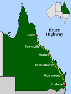
The Bruce Highway is a major highway in Queensland, Australia. Commencing in the state capital, Brisbane, it passes through areas close to the eastern coast on its way to Cairns in Far North Queensland. The route is part of the Australian National Highway and also part of Highway 1, the longest highway route in Australia. Its length is approximately 1,679 kilometres (1,043 mi); it is entirely sealed with bitumen. The highway is named after a popular former Queensland and federal politician, Harry Bruce. Bruce was the state Minister for Works in the mid-1930s when the highway was named after him. The highway once passed through Brisbane, but was truncated at Bald Hills when the Gateway Motorway became National Highway 1 upon its opening in December 1986.

Caboolture is a town and suburb in Moreton Bay Region, Queensland, Australia. In the 2016 census, the suburb of Caboolture had a population of 26,433 people. It is located on the north side of the Caboolture River, which separates the town from Morayfield and Caboolture South.
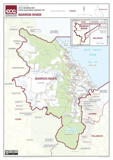
Barron River is an electoral district of the Legislative Assembly in the Australian state of Queensland.
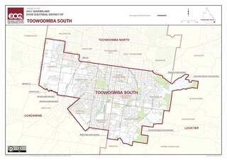
Toowoomba South is an electoral district of the Legislative Assembly in the Australian state of Queensland. It was created with the 1972 redistribution, and replaced the abolished Toowoomba East.
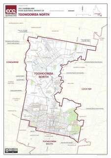
Toowoomba North is an electoral district of the Legislative Assembly in the Australian state of Queensland. It was created with the 1972 redistribution. It replaced the abolished electorate of Toowoomba West. Toowoomba North is largely based around the upper half of the city of Toowoomba.
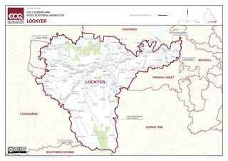
Lockyer is an electoral district of the Legislative Assembly in the Australian state of Queensland.
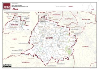
Logan is an electoral district in southern Queensland, Australia.
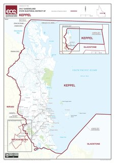
Keppel is an electoral district in the state of Queensland, Australia.
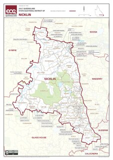
Nicklin is an electoral district of the Legislative Assembly in the Australian state of Queensland. The electorate is centred in the Sunshine Coast hinterland, and stretches north to Black Mountain, south to Palmwoods and Montville, and west to Kenilworth, including Conondale National Park. It includes notable localities such as Nambour, Yandina, Cooroy, Bli Bli, Mapleton and Woombye.

Everton is an electoral district of the Legislative Assembly in the Australian state of Queensland.
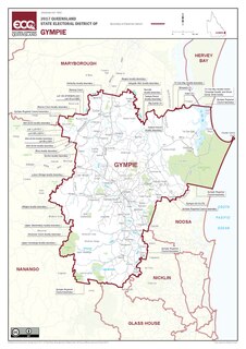
Gympie is an electoral district of the Legislative Assembly in the Australian state of Queensland The electorate is centred on the city of Gympie and stretches north to Rainbow Beach and as far south to Pomona.

Greenslopes is an electoral district of the Legislative Assembly in the Australian state of Queensland.

Chatsworth is an electoral district of the Legislative Assembly in the Australian state of Queensland. The electorate is centred on the south-eastern suburbs of Brisbane and stretches north to Tingalpa, west to Carina Heights, east to Tingalpa Creek and south to Bulimba Creek.
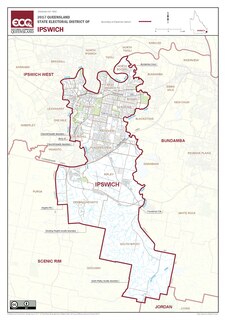
Ipswich is a Legislative Assembly of Queensland electoral district on the Brisbane River, west of Brisbane in the Australian state of Queensland. The electorate includes Ipswich and its suburbs, south and east of the Bremer River, west of Bundamba Creek and north of the Cunningham Highway.

Nudgee is an electoral district of the Legislative Assembly in the Australian state of Queensland. It is based in the north-eastern suburbs of Brisbane.
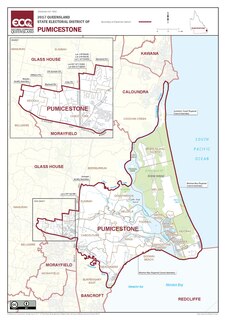
Pumicestone is an electoral district of the Legislative Assembly in the Australian state of Queensland.
Caboolture was an electoral district of the Legislative Assembly in the Australian state of Queensland. It existed from 1977 to 2001 and centred on the community of Caboolture between Brisbane and the Sunshine Coast.
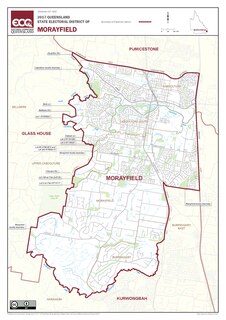
Morayfield is an electoral district of the Legislative Assembly in the Australian state of Queensland. It is located in the northern outskirts of Brisbane, south of the Sunshine Coast.
Brisbane North was an electoral district which elected two members to the Legislative Assembly of Queensland in the Australian state of Queensland from 1888 until 1912. It replaced the electoral district of North Brisbane.
The electoral district of Townsville North was a Legislative Assembly electorate in the state of Queensland, Australia.

