Electoral district of Warrego

Last updated

Warrego
QueenslandLegislative Assembly
ECQ-2017-Final-Warrego.pdf
Electoral map of Warrego 2017
State Queensland
Created1865
MP Ann Leahy
Party Liberal National
Namesake Warrego River
Electors 29,307 (2020)
Area337,812 km2 (130,429.9 sq mi)
Coordinates 26°52′S146°9′E / 26.867°S 146.150°E / -26.867; 146.150 Coordinates: 26°52′S146°9′E / 26.867°S 146.150°E / -26.867; 146.150
Electorates around Warrego:
South Australia Gregory Callide
Nanango
South Australia Warrego Condamine
Southern Downs
South Australia New South Wales New South Wales
2008 Electoral map of Warrego QLD - Warrego 2008.png
2008 Electoral map of Warrego

Warrego is an electoral district of the Legislative Assembly in the Australian state of Queensland.

Contents

The electorate lies in the extreme southwest of Queensland, running along the western part of the border with New South Wales. It includes the large town of Dalby, as well as the rural centres of Surat, Roma, Tara, Charleville, Augathella, St George and Cunnamulla.

History

The electoral district of Warrego was created by the Additional Members Act of 1864 which introduced six new single-member electorates. [1] A by-election was held to fill the seat. The nomination date was 18 March 1865 and the election was held on 25 March 1865. [2]

Warrego was, as with the rest of the state, held by independents and loose groupings of members around the government of the day until the first years of the twentieth century, when the partisan system took hold. It then became a stronghold of the centre-left Labor Party, which held it without interruption from 1908 to 1974. The decline of the rural working class gradually changed the demographics of the electorate, however, and it fell to the conservative National Party in 1974, at the height of the popularity of the Bjelke-Petersen government. The National Party significantly increased its hold on the electorate thereafter, and it is today one of the party's safest seats. The current member, Ann Leahy, has held the seat since 2015.

Members for Warrego

MemberPartyTerm
  Frederick Forbes Unaligned1865–1867
  Graham Mylne Unaligned1867–1868
 Sir Arthur Hodgson Unaligned1868–1869
 Sir Thomas McIlwraith Ministerialist1870–1871
  Archibald Buchanan Ministerialist1871–1873
  William Henry Walsh Ministerialist1873–1878
  Ernest James Stevens Independent1878–1883
  John Donaldson Independent/Ministerialist1883–1888
  Richard Casey Unaligned1888–1893
  James Crombie Ministerialist1893–1898
  William Hood Ministerialist1898–1899
  David Bowman Labour 1899–1902
  Patrick Leahy Ministerialist/Opposition1902–1907
  George Barber Labour 1907
  Patrick Leahy Ministerialist/Opposition1907–1908
  Harry Coyne Labor 1908–1923
  Randolph Bedford Labor 1923–1941
  Harry O'Shea Labor 1941–1950
  John Dufficy Labor 1951–1969
  Jack Aiken Labor 1969–1974
  Neil Turner National 1974–1986
  Howard Hobbs National 1986–2008
  Liberal National 2008–2015
  Ann Leahy Liberal National 2015–present

Election results

2020 Queensland state election: Warrego [3]
PartyCandidateVotes%±%
Liberal National Ann Leahy 14,10055.98+8.35
Labor Mark O'Brien4,96619.72−1.97
Katter's Australian Rick Gurnett2,84211.28−9.96
One Nation Joshua Coyne2,2248.83+8.83
Greens Joshua Sanderson5692.26−0.83
Independent Mark Stone4871.93−1.51
Total formal votes25,18897.97+2.17
Informal votes5212.03−2.17
Turnout 25,70987.72−0.71
Two-party-preferred result
Liberal National Ann Leahy 18,42473.15+13.69
Labor Mark O'Brien6,76426.85+26.85
Liberal National hold 

Related Research Articles

Electoral district of Bulimba State electoral district of Queensland, Australia

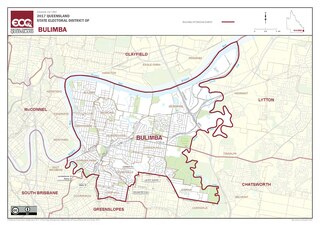
Bulimba is an electoral district of the Legislative Assembly in the Australian state of Queensland.

Cunningham was an electoral district of the Legislative Assembly in the Australian state of Queensland from 1888 to 2009.

Electoral district of Bundamba State electoral district of Queensland, Australia

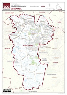
Bundamba is a Legislative Assembly of Queensland electoral division in the state of Queensland, Australia.

Electoral district of South Brisbane State electoral district of Queensland, Australia

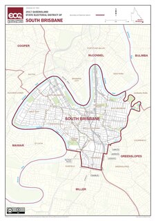
South Brisbane, also known as Brisbane South, is an electoral district of the Legislative Assembly of Queensland. The electorate encompasses suburbs in Brisbane's inner-south, stretching from East Brisbane to West End, and south to Annerley. Parts of Greenslopes and Coorparoo are also located in the electorate.

Electoral district of Nicklin State electoral district of Queensland, Australia

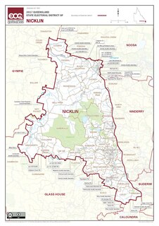
Nicklin is an electoral district of the Legislative Assembly in the Australian state of Queensland. The electorate is centred in the Sunshine Coast hinterland, and stretches north to Black Mountain, south to Palmwoods and Montville, and west to Kenilworth, including Conondale National Park. It includes notable localities such as Nambour, Yandina, Cooroy, Bli Bli, Mapleton and Woombye.

Electoral district of Kawana State electoral district of Queensland, Australia

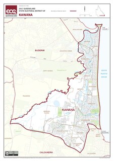
Kawana is an electoral district of the Legislative Assembly in the Australian state of Queensland. Based on the Sunshine Coast, the district has been held by both sides of politics over its short history.

Electoral district of Gympie State electoral district of Queensland, Australia

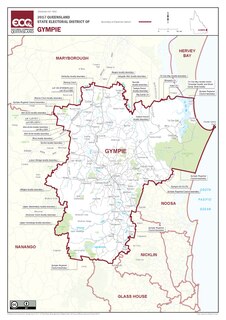
Gympie is an electoral district of the Legislative Assembly in the Australian state of Queensland The electorate is centred on the city of Gympie and stretches north to Rainbow Beach and as far south to Pomona.

Electoral district of Rockhampton

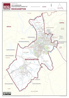
Rockhampton is an electoral district of the Legislative Assembly in the Australian state of Queensland.

Darling Downs was an electoral district of the Legislative Assembly in the Australian state of Queensland. It was named for the Darling Downs region.

Electoral district of Maryborough (Queensland) State electoral district of Queensland, Australia

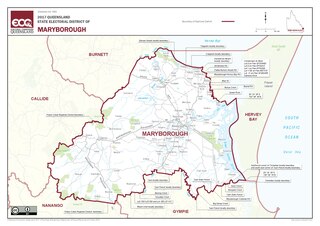
Maryborough is an electoral district of the Legislative Assembly in the Australian state of Queensland.

Electoral district of Springwood State electoral district of Queensland, Australia

Springwood is an electoral district of the Legislative Assembly in the Australian state of Queensland.

Roma was an electoral district of the Legislative Assembly in the Australian state of Queensland from 1950 to 1992.

Kennedy was an electoral district of the Legislative Assembly in the Australian state of Queensland.

Barcoo was an electoral district of the Legislative Assembly in the Australian state of Queensland from 1885 to 1972.

Wide Bay was a Legislative Assembly electorate in the state of Queensland.

Clermont was a Legislative Assembly electorate in the state of Queensland. The electorate was based on the town of Clermont and surrounding areas.

Mitchell was a Legislative Assembly electorate in the state of Queensland, Australia.

Charles Fitzsimmons (politician)

Charles Fitzsimmons (1802—1876) was a politician and sugar farmer in Queensland, Australia. He was a Member of the Queensland Legislative Assembly.

The Warrego colonial by-election, 1865 was a by-election held on 25 March 1865 in the electoral district of Warrego for the Queensland Legislative Assembly.

John Gore Jones (1820–1868) was a politician in Queensland, Australia. He was a Member of the Queensland Legislative Assembly.

References

  1. "Representatives of Queensland State Electorates 1860-2017" (PDF). Queensland Parliamentary Record 2012-2017: The 55th Parliament. Queensland Parliament. Archived from the original on 27 April 2020. Retrieved 27 April 2020.CS1 maint: unfit URL (link)
  2. "NON-INFECTIOUSNESS OF PLEURO-PNEUMONIA". The Darling Downs Gazette and General Advertiser . Toowoomba, Qld.: National Library of Australia. 1 February 1865. p. 4. Retrieved 11 March 2014.
  3. 2020 State General Election – Warrego – District Summary, ECQ.