Electoral district of Moggill

Last updated

Moggill
QueenslandLegislative Assembly
ECQ-2017-Final-Moggill.pdf
Electoral map of Moggill 2017
State Queensland
MP Christian Rowan
Party Liberal National
Namesake Moggill
Electors 34,935 (2020)
Area307 km2 (118.5 sq mi)
Coordinates 27°28′S152°49′E / 27.467°S 152.817°E / -27.467; 152.817 Coordinates: 27°28′S152°49′E / 27.467°S 152.817°E / -27.467; 152.817
Electorates around Moggill:
Nanango Pine Rivers Cooper
Lockyer Moggill Maiwar
Ipswich West Bundamba
Inala
Mount Ommaney
Electoral map of Moggill 2008 QLD - Moggill 2008.png
Electoral map of Moggill 2008

Moggill is an electoral district in the Legislative Assembly of Queensland in the state of Queensland, Australia. The electorate is held by Dr Christian Rowan, for the Liberal National Party of Queensland.

Contents

Moggill encompasses the suburbs on the south-western fringe of Brisbane, and is named for the suburb of Moggill. It also includes Chapel Hill, Pullenvale, Brookfield, Kenmore, Karana Downs and Mount Crosby. It had long been the most conservative seat in Brisbane. Indeed, during the Labor landslides of 2001 and 2004, it was the only non-Labor seat in Brisbane.

However, in recent years, it has become somewhat more marginal. At its height in 2012, the LNP sat on a majority of 23.9 percent, which was pared back to 8.2 percent in 2015, five percent in 2017 and three percent in 2020. Presently, it is one of only five non-Labor seats in the capital.

Most of the seat is located within the equally conservative federal seat of Ryan.

History

Democracy sausages being barbecued at Kenmore State School in the electoral district of Moggill, 2017 Queensland state election, 25 November 2017 Democracy sausages being barbecued at Kenmore State School in the electoral district of Moggill at the 2017 Queensland state election.jpg
Democracy sausages being barbecued at Kenmore State School in the electoral district of Moggill, 2017 Queensland state election, 25 November 2017

The electoral district of Moggill was created in the 1986 redistribution combining part of the electoral district of Mount Coot-tha with parts of the electoral district of Ipswich West. In 1991, a small portion east of the Centenary Highway was removed. [1]

Members for Moggill

MemberPartyTerm
  Bill Lickiss Liberal 1986–1989
  David Watson Liberal 1989–2004
  Bruce Flegg Liberal 2004–2008
  Liberal National 2008–2015
  Christian Rowan Liberal National 2015–present

Election results

2020 Queensland state election: Moggill [2]
PartyCandidateVotes%±%
Liberal National Christian Rowan 14,88846.89−1.79
Labor Roberta Albrecht9,01228.38+1.88
Greens Lawson McCane6,53620.58−0.32
One Nation Bruce Mitchell9222.90+2.90
Civil Liberties & Motorists Amy Rayward3951.24−2.68
Total formal votes31,75398.31+1.05
Informal votes5461.69−1.05
Turnout 32,29992.45+1.16
Two-party-preferred result
Liberal National Christian Rowan 17,01653.59−1.44
Labor Roberta Albrecht14,73746.41+1.44
Liberal National hold Swing −1.44

Related Research Articles

Legislative Assembly of Queensland

The Legislative Assembly of Queensland is the sole chamber of the unicameral Parliament of Queensland established under the Constitution of Queensland. Elections are held every four years and are done by full preferential voting. The Assembly has 93 members, who have used the letters MP after their names since 2000.

Electoral district of Brisbane Central

Brisbane Central was an electoral division in the state of Queensland, Australia.

Electoral district of Bulimba State electoral district of Queensland, Australia

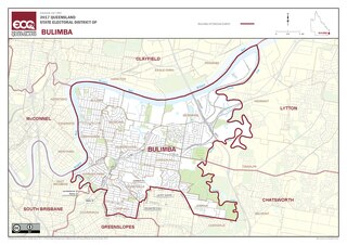
Bulimba is an electoral district of the Legislative Assembly in the Australian state of Queensland.

Bruce Flegg Australian politician

Dr Bruce Stephen Flegg is a former Australian politician. He was a member of the Queensland Legislative Assembly from 2004 to 2015, representing the electorate of Moggill in south-western Brisbane for the Liberal Party and its successor the Liberal National Party. He was the leader of the state Liberal Party from 2006 to 2007 and served as Minister for Housing and Public Works in the Newman government from April to November 2012.

Electoral district of Lockyer State electoral district of Queensland, Australia

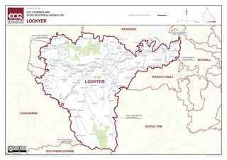
Lockyer is an electoral district of the Legislative Assembly in the Australian state of Queensland.

Electoral district of Gladstone State electoral district of Queensland, Australia

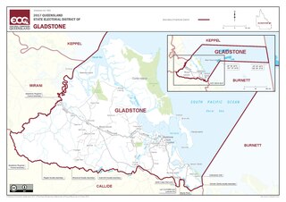
Gladstone is an electoral district of the Legislative Assembly in the Australian state of Queensland.

Electoral district of Yeerongpilly Former state electorate in Queensland, Australia

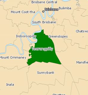
Yeerongpilly was a Legislative Assembly electorate the state of Queensland. Named for the suburb with the same name, the electorate was renamed before the 2001 elections from the previous name of Yeronga. In 2017, it was abolished and replaced by the electoral district of Miller.

Electoral district of Mount Coot-tha

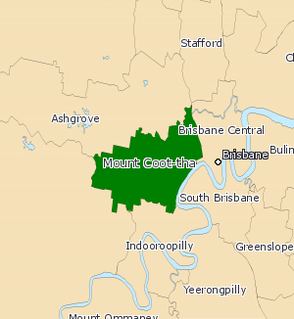
Mount Coot-tha was an electoral district in the Legislative Assembly of Queensland in the state of Queensland, Australia from 1950 to 2017.

Electoral district of Cairns State electoral district of Queensland, Australia

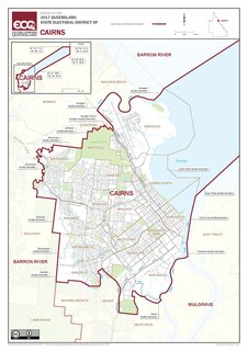
Cairns is an electoral district in the Legislative Assembly of Queensland in the state of Queensland, Australia.

Electoral district of South Brisbane State electoral district of Queensland, Australia

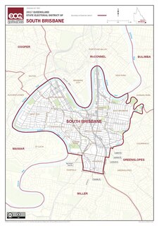
South Brisbane, also known as Brisbane South, is an electoral district of the Legislative Assembly of Queensland. The electorate encompasses suburbs in Brisbane's inner-south, stretching from East Brisbane to West End, and south to Annerley. Parts of Greenslopes and Coorparoo are also located in the electorate.

Charters Towers was an electoral district of the Legislative Assembly in the Australian state of Queensland. It has had three incarnations, most recently being created as part of a redistribution in 1991 and lasting until 2008.

Electoral district of Mackay State electoral district of Queensland, Australia

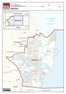
Mackay is a Legislative Assembly of Queensland electoral district in North Queensland, Australia, encompassing the inner suburbs of the city of Mackay. Outer suburbs of the city are included in the neighbouring electorates of Mirani and Whitsunday.

Electoral district of Inala State electoral district of Queensland, Australia

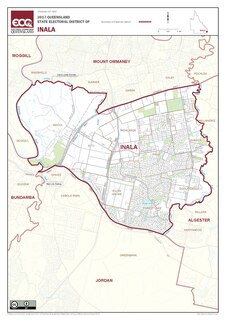
The electoral district of Inala is an electoral district of the Legislative Assembly of Queensland in south-west Brisbane. It includes the suburbs of Inala, Ellen Grove, Forest Lake, Doolandella, Durack, Wacol, Richlands and parts of Oxley. It borders the electoral districts of Mount Ommaney, Miller, Algester, Jordan, Bundamba and Moggill.

Electoral district of Mount Isa

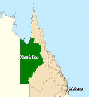
Mount Isa was an electoral district in the Legislative Assembly of Queensland in the state of Queensland, Australia from 1972 to 2017.

Electoral district of Surfers Paradise State electoral district of Queensland, Australia

Surfers Paradise is an electoral district of the Legislative Assembly in the Australian state of Queensland. Located in the central portion of the Gold Coast, it is named for Surfers Paradise, the largest suburb of the Gold Coast.

Electoral district of Stafford State electoral district of Queensland, Australia

Stafford is a Legislative Assembly of Queensland electoral district in the state of Queensland, Australia.

Electoral district of Ferny Grove State electoral district of Queensland, Australia

Ferny Grove is one of the 89 electoral districts for the Legislative Assembly of Queensland in Australia. Located in northwest Brisbane, it is named for the suburb of Ferny Grove. It was first created in 1992, and was represented by Labor from its creation until the 2012 election, in which the LNP won with a 59.5 percent two-party vote.

Electoral district of Woodridge State electoral district of Queensland, Australia

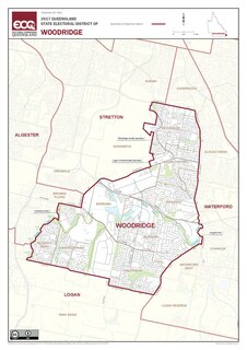
Woodridge is an electoral district of the Legislative Assembly in the Australian state of Queensland.

2015 Queensland state election

The 2015 Queensland state election was held on 31 January 2015 to elect all 89 members of the unicameral Legislative Assembly of Queensland.

Toowong was an electoral district of the Legislative Assembly in the Australian state of Queensland from 1888 to 1992. It was centred on the Northern Brisbane suburb of Toowong.

References

  1. "Representatives of Queensland State Electorates 1860-2017" (PDF). Queensland Parliamentary Record 2012-2017: The 55th Parliament. Queensland Parliament. Archived from the original on 27 April 2020. Retrieved 10 August 2015.CS1 maint: unfit URL (link)
  2. 2020 State General Election – Moggill – District Summary, ECQ.