
Protected areas of Australia include Commonwealth and off-shore protected areas managed by the Australian government, as well as protected areas within each of the six states of Australia and two self-governing territories, the Australian Capital Territory and the Northern Territory, which are managed by the eight state and territory governments.

Protected areas of South Australia, consisting of protected areas located within South Australia and its immediate onshore waters and which are managed by South Australian Government agencies. As of 2018, South Australia contained 359 separate protected areas declared under the National Parks and Wildlife Act 1972, the Crown Land Management Act 2009 and the Wilderness Protection Act 1992. Together, they cover a total land area of 211,387.48 km2 (81,617.16 sq mi) or 21.5% of the state's area.
Kati Thanda-Lake Eyre National Park is a protected area in the Australian state of South Australia. It is located 697 km north of the state capital of Adelaide within the gazetted locality of Lake Eyre. It contains both the North and South sections of Lake Eyre as well as sections of the Tirari Desert.

Blue Lake National Park was a former protected area in Queensland, Australia, located on North Stradbroke Island about 44 kilometres (27 mi) east of Brisbane. Blue Lake National Park is now a part of the Naree Budjong Djara National Park. Access was provided by road 9 kilometres (5.6 mi) west of Dunwich.
Coalstoun Lakes is a national park in Queensland, Australia, 236 km (147 mi) northwest of Brisbane. It features a volcano, Mount Le Brun, which has two craters that contain intermittent crater lakes. Mount Le Brun is one of the youngest volcanic formations in Australia, although it was formed more than 600,000 years ago. Coalstoun Lakes is Queensland's smallest national park.

Crater Lakes is a national park in Far North Queensland, Queensland, Australia, 1367 km northwest of Brisbane. The park contains two volcanically-formed lakes, Lake Barrine and Lake Eacham (Yidyam). Both lakes have walking trails around each lake; boat tours are also given at Lake Barrine.

Great Sandy National Park is a coastal national park in the Fraser Coast Region, Queensland, Australia.

Baga National Park is a national park in Queensland, Australia, 531 kilometres (330 mi) northwest of Brisbane.
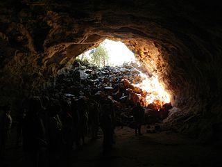
The Undara Volcanic National Park is a national park in the Shire of Etheridge, Queensland, Australia. It is situated 275 kilometres southwest of Cairns just off the Gulf Developmental Road. The park was established in 2009 to protect Australia's longest lava tube and the unique fauna and flora found of the area. The basalts of the area form part of the Cenozoic McBride Basalt (Volcanic) Provence. The volcanics are all less than 8 million years old (Ma) with the youngest only 7,000 years old.
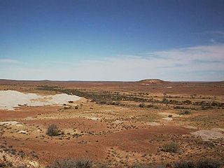
Lake Torrens is a large ephemeral, normally endorheic salt lake in central South Australia. After sufficiently extreme rainfall events, the lake flows out through the Pirie-Torrens corridor to the Spencer Gulf.

North Stradbroke Island, colloquially Straddie or North Straddie, is an island that lies within Moreton Bay in the Australian state of Queensland, 30 kilometres (19 mi) southeast of the centre of Brisbane. Originally there was only one Stradbroke Island but in 1896 it split into North Stradbroke Island and South Stradbroke Island separated by the Jumpinpin Channel. The Quandamooka people are the traditional owners of North Stradbroke island.

Munga-Thirri–Simpson Desert National Park, part of which was formerly Munga-Thirri–Simpson Desert Conservation Park, Simpson Desert Conservation Park, and Simpson Desert National Park, is a protected area located in the far north of the Australian state of South Australia, near its border with Queensland and the Northern Territory. As of November 2021 it is the largest national park in Australia, covering 3,600,000 ha (14,000 sq mi).
Lake Frome National Park, formerly Lake Frome Regional Reserve, is a protected area located in the Australian state of South Australia about 750 kilometres (470 mi) north-east of the state capital of Adelaide, in the Northern Flinders Ranges. It covers the full extent of Lake Frome, an endorheic and ephemeral salt lake. It has an area of 2,582.40 square kilometres (997.07 sq mi).

An Indigenous Protected Area (IPA) is a class of protected area used in Australia; each is formed by voluntary agreement with Indigenous Australians, and declared by Aboriginal Australians and Torres Strait Islander representative organisations. Each is formally recognised by the Australian Government as being part of its National Reserve System. The areas may comprise land and sea, and are managed by Indigenous groups for the conservation of biodiversity. Managing IPAs also helps to protect the cultural values of their country for future generations, and has benefits for Indigenous health, education, economic and social cohesion.
The Moreton Bay Marine Park was established in 1993 to protect ecologically significant habitats in Moreton Bay. The marine park extends from Caloundra south to the southern tip of South Stradbroke Island. The marine park's border extends up to the highest tidal mark and covers a total of 3,400 km2.

The Coongie Lakes is a freshwater wetland system located in the Far North region of South Australia. The 21,790-square-kilometre (8,410 sq mi) lakes system is located approximately 1,046 kilometres north of the Adelaide city centre. The wetlands includes lakes, channels, billabongs, shallow floodplains, deltas, and interdune swamps. It lies on the floodplain of Cooper Creek, an ephemeral river flowing through a desert landscape in the Lake Eyre Basin which rarely, after occasional large floods, empties into Lake Eyre. The wetland system has been recognised both as being of international importance by designation under the Ramsar Convention with a listing on 15 June 1987 and being nationally important within Australia with a listing in A Directory of Important Wetlands in Australia (DIWA). Its extent includes the regional town of Innamincka, the Malkumba-Coongie Lakes National Park, the Innamincka Regional Reserve, the Strzelecki Regional Reserve and the Coongie Lakes Important Bird Area.

North Stradbroke Island is a locality on part of the island of the same name in the City of Redland, Queensland, Australia. In the 2021 census, North Stradbroke Island had a population of 181 people.
Beachport Conservation Park, formerly the Beachport National Park, is a protected area located in the Limestone Coast of South Australia about 80 kilometres north-west of Mount Gambier and immediately north of the township of Beachport.
Elliot Price Conservation Park, formerly the Elliot Price Wilderness National Park, is a protected area in the Australian state of South Australia located in the gazetted locality of Lake Eyre with its southern boundary being located about 90 kilometres north west of Marree.

Nandi is a rural locality in the Western Downs Region, Queensland, Australia. In the 2021 census, Nandi had a population of 105 people.
