Queensland is the second largest state in Australia. It contains 472 separate protected areas with a total land area of 69,388 km2 (26,791 sq mi). 223 of these are National parks, which is the highest number of any Australian state or territory, totalling 65,871 km2 (25,433 sq mi). Seven others are Scientific National Parks, totalling 522 km2 (202 sq mi).

Brampton Islands is a national park in the Mackay Region, Queensland, Australia, 834 kilometres (518 mi) northwest of Brisbane. The park covers much of Brampton Island and all of Carlisle Island.
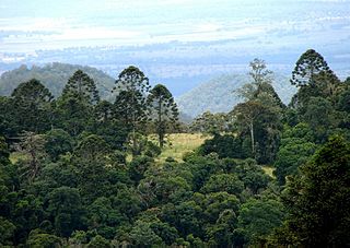
Bunya Mountains is a national park in the South Burnett Region, Queensland, Australia.
Edmund Kennedy is a national park in Queensland, Australia, 1269 km northwest of Brisbane. The national park is part of the Wet Tropics World Heritage Area. It was named after Edmund Kennedy, a mid-nineteenth century explorer.

Goodedulla is a national park in Queensland, Australia, 573 km (356 mi) northwest of Brisbane. The park is located in the centre of the Brigalow Belt.

Green Island National Park is a protected area declared over a small coral cay of Green Island, Cairns Region, Queensland, Australia. It is known to the local Gungganyji Aboriginal peoples as Dabuukji. The Gungganyji people used the island as an initiation ground.

Kondalilla is a national park in the Blackall Range of South East Queensland, Australia, 91 km north of Brisbane. William Skene founded this area on his property while searching for lost cattle. He named it Bon Accord before giving it to the Queensland Government who, during the fifties, renamed it Kondalilla which is an Aboriginal word for running water. The area was first officially protected in 1906 as a recreational area, becoming a national park in 1945.

Lakefield is a national park in Lakefield, Shire of Cook, Queensland, Australia, 1,707 km northwest of Brisbane and 340 km north-west of Cairns by road, on Cape York Peninsula. At 5,370 km2 making it bigger than Lakefield is the second largest park in Queensland and a popular place for fishing and camping.

Boodjamulla National Park, formerly known as Lawn Hill National Park, is a national park in the Shire of Burke, Queensland, Australia.

Mount Colosseum is a national park in Central Queensland, Australia, 370 kilometres (230 mi) northwest of Brisbane and about 6 kilometres (4 mi) south of the town of Miriam Vale.

Noosa National Park is a national park in Queensland, Australia, 121 km north of Brisbane. It is situated near Noosa Heads between the Pacific Ocean and the Sunshine Coasts's northern area of urban development and extends southwards, past Lake Weyba to Coolum.
Southwood is a national park in Queensland, Australia, 288 km west of Brisbane.

Tamborine is a national park in the Gold Coast hinterland and is a part of the Scenic Rim Regional Council of South East Queensland, Australia, 45 km (28 mi) south of Brisbane.

The City Botanic Gardens is a heritage-listed botanic garden on Alice Street, Brisbane City, City of Brisbane, Queensland, Australia. It was also known as Queen's Park. It is located on Gardens Point in the Brisbane CBD and is bordered by the Brisbane River, Alice Street, George Street, Parliament House and Queensland University of Technology's Gardens Point campus.

The Daintree Rainforest is a region located on the north east coast of Queensland, Australia, north of Mossman and Cairns. At around 1,200 square kilometres (460 sq mi), the Daintree is a part of the largest continuous area of tropical rainforest on the Australian continent. The Daintree Rainforest is a part of the Wet Tropics Rainforest, that spans across the Cairns Region. The Wet Tropics Rainforest is the oldest continually surviving tropical rainforest in the world. Along the coastline north of the Daintree River, tropical forest grows right down to the edge of the sea.
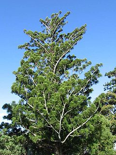
Araucaria cunninghamii is a species of Araucaria known as hoop pine. Other less commonly used names include colonial pine, Queensland pine, Dorrigo pine, Moreton Bay pine and Richmond River pine. The scientific name honours the botanist and explorer Allan Cunningham, who collected the first specimens in the 1820s.

Everton Park is a suburb of Brisbane, Queensland, Australia. It is about eight kilometres north of the Brisbane CBD. This suburb is predominantly residential, with more than a quarter of the population residing in semi-detached and higher density dwellings. Everton Park is a Neighbourhood Watch area.

Mount Greville is a cone-shaped and deeply fissured mountain in South East Queensland, Australia. The mountain rises 720 m above sea level and is part of the Moogerah Peaks National Park. It lies approximately 100 km south west of Brisbane just outside the town of Boonah. Other prominent peaks in this Scenic Rim group of mountains includes Mount Edwards, Mount Moon and Mount French.

The geography of Queensland in the north-east of Australia, is varied. It includes tropical islands, sandy beaches, flat river plains that flood after monsoon rains, tracts of rough, elevated terrain, dry deserts, rich agricultural belts and densely populated urban areas.
Great Palm Island, also known as Palm Island, or by the Aboriginal name Bwgcolman; is a tropical island with a resident community of about 2,000 people. The island has an area of 55 km2 (21 sq mi). The official area figure of 70.9 km² refers to Aboriginal Shire of Palm Island and includes nine smaller islands. It is in Queensland, Australia, off the east coast of northern Queensland, situated 65 kilometres (40 mi) northwest of Townsville, and 800 kilometres (500 mi) north of the Tropic of Capricorn. The Australia Post lists the local post office as Palm Island, QLD. It is the main island of the Greater Palm group, and consists of small bays, sandy beaches and steep forested mountains rising to a peak of 548 metres (1,798 ft). The ocean surrounding the island is part of the Great Barrier Reef Marine Park where extraction and fishing are regulated.