Mount Aberdeen National Park

Last updated

Mount Aberdeen National Park
Queensland
IUCN category II (national park)
Australia Queensland location map.svg
Red pog.svg
Mount Aberdeen National Park
Coordinates 20°11′55″S147°55′16″E / 20.19861°S 147.92111°E / -20.19861; 147.92111 Coordinates: 20°11′55″S147°55′16″E / 20.19861°S 147.92111°E / -20.19861; 147.92111
Established 1967
Area 29.10 km2 (11.24 sq mi)
Managing authorities Queensland Parks and Wildlife Service
See also Protected areas of Queensland

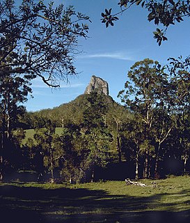
Mount Aberdeen is a national park in North Queensland, Australia, 961 km northwest of Brisbane, and 40 km south-west of Bowen. The Park is in 2 sections; the Mount Aberdeen section of 1840ha dedicated in 1952, and the Highlanders Bonnet section of 1370ha dedicated in 1967. The Park has no direct public access road or public facilities. Both Mount Aberdeen and Highlander's Bonnet are composed of granite, with Mount Aberdeen summit reaching 901 m and Highlander's Bonnet 624 m.

North Queensland Region in Queensland, Australia

North Queensland or the Northern Region is the northern part of the Australian state of Queensland that lies just south of Far North Queensland. Queensland is a massive state, larger than many countries, and the tropical northern part of it has been historically remote and undeveloped, resulting in a distinctive regional character and identity.

Australia Country in Oceania

Australia, officially the Commonwealth of Australia, is a sovereign country comprising the mainland of the Australian continent, the island of Tasmania and numerous smaller islands. It is the largest country in Oceania and the world's sixth-largest country by total area. The neighbouring countries are Papua New Guinea, Indonesia and East Timor to the north; the Solomon Islands and Vanuatu to the north-east; and New Zealand to the south-east. The population of 25 million is highly urbanised and heavily concentrated on the eastern seaboard. Australia's capital is Canberra, and its largest city is Sydney. The country's other major metropolitan areas are Melbourne, Brisbane, Perth and Adelaide.

Bowen, Queensland Town in Queensland, Australia

Bowen is a coastal town and locality in the Whitsunday Region on the eastern coast of Queensland, Australia. The town of Merinda and the Abbot Point coal shipping port are also within the locality of Bowen. At the 2016 census, Bowen had a population of 10,377.

The park is notable for containing the sole regional occurrence of tropical cloud forest at the summit of Mount Aberdeen, with large areas of hoop pine ( Araucaria cunninghamii ) on the slopes of both peaks. Semi-evergreen vine thicket (subtropical dry broadleaf forest) is found in sheltered areas. There is also an unusual red gum-snow grass community in the park that is found nowhere else in Queensland. Mammals recorded in the park include unadorned rock wallabies, eastern grey kangaroos, common wallaroos, northern quolls and koalas. Found in the Park is the Mt Elliott grey ant, which is at its southern limit. [1]

Cloud forest rainforest

A cloud forest, also called a water forest and primas forest, is a generally tropical or subtropical, evergreen, montane, moist forest characterized by a persistent, frequent or seasonal low-level cloud cover, usually at the canopy level, formally described in the International Cloud Atlas (2017) as silvagenitus. Cloud forests often exhibit an abundance of mosses covering the ground and vegetation, in which case they are also referred to as mossy forests. Mossy forests usually develop on the saddles of mountains, where moisture introduced by settling clouds is more effectively retained.

<i>Araucaria cunninghamii</i> species of plant

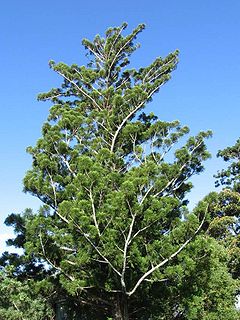
Araucaria cunninghamii is a species of Araucaria known as hoop pine. Other less commonly used names include colonial pine, Queensland pine, Dorrigo pine, Moreton Bay pine and Richmond River pine. The scientific name honours the botanist and explorer Allan Cunningham, who collected the first specimens in the 1820s.

Eastern grey kangaroo species of mammal

The eastern grey kangaroo is a marsupial found in southern and eastern Australia, with a population of several million. It is also known as the great grey kangaroo and the forester kangaroo. Although a big eastern grey male typically masses around 66 kg and stands almost 2 m (6.6 ft.) tall, the scientific name, Macropus giganteus, is misleading: the red kangaroo of the semi-arid inland is larger, weighing up to 90 kg.

See also

Related Research Articles

Burleigh Head National Park Protected area in Queensland, Australia

Burleigh Head is a small national park at Burleigh Heads in the City of Gold Coast in South East Queensland, Australia.

Deepwater National Park Protected area in Queensland, Australia

Deepwater is a coastal national park in Queensland, Australia, 375 km north of Brisbane. It protects an area of sand dunes and coastal heaths in the Deepwater Creek catchment. The area is one of the few remaining pristine freshwater catchments on Queensland's east coast. Deepwater National Park was established in 1988 and covers 4,090 ha.

Glass House Mountains National Park Protected area in Queensland, Australia

Glass House Mountains National Park is a heritage-listed national park at Glass House Mountains, Sunshine Coast Region, Queensland, Australia. It is also known as Beerburrum Forest Reserve 1. It is 70 km (43 mi) north of Brisbane and consists of a flat plain punctuated by rhyolite and trachyte volcanic plugs, the cores of extinct volcanoes that formed 27 million to 26 million years ago. The mountains would once have had pyroclastic exteriors, but these have eroded away.

Moogerah Peaks National Park Protected area in Queensland, Australia

Moogerah Peaks is a National Park in the Fassifern Valley of South East Queensland, Australia, located approximately 70 km south west of the state capital Brisbane. The 676-hectare park consists of four separate protected areas which surround volcanic peaks and rocky cliffs near Moogerah Dam.

Mount Barney National Park Protected area in Queensland, Australia

Mount Barney National Park is a national park in Queensland (Australia), 90 km southwest of Brisbane. It amalgamated the adjacent Mount Lindesay National Park in 1980. It is part of the Scenic Rim Important Bird Area, identified as such by BirdLife International because of its importance in the conservation of several species of threatened birds.

Mount Walsh National Park Protected area in Queensland, Australia

Mount Walsh is a national park in Queensland, Australia, 230 km northwest of Brisbane.

Mount Bartle Frere mountain in Queensland, Australia

Mount Bartle Frere is the highest mountain in Queensland at an elevation of 1,611 metres (5,285 ft). The mountain was named after Sir Henry Bartle Frere, a British colonial administrator and then president of the Royal Geographical Society by George Elphinstone Dalrymple in 1873. Bartle Frere was British Governor of Cape Colony at the outset of the Zulu Wars. The Aboriginal name for the mountain is Chooreechillum.

Mount Warning Mountain in north-eastern New South Wales, Australia

Mount Warning, a mountain in the Tweed Range in the Northern Rivers region of New South Wales, Australia, was formed from a volcanic plug of the now-gone Tweed Volcano. The mountain is located 14 kilometres (9 mi) west-south-west of Murwillumbah, near the border between New South Wales and Queensland. Lieutenant James Cook saw the mountain from the sea and named it Mount Warning.

Mount Cordeaux mountain in Australia

Mount Cordeaux is a mountain near Brisbane, Australia and rises 1,135 m. It lies to the immediate north of Cunninghams Gap in the Main Range National Park. It is known to the Aboriginal People as Niamboyoo, however, the meaning is unknown. It appears that early usage on names for the mountain varied, as a 29 September 1897 report in the Warwick Examiner and Times, refers to "the well-known Cunningham's Gap, with its twin sentinel peaks, Coonyinirra and Niamboyoo".

Shasta–Trinity National Forest

The Shasta–Trinity National Forest is a federally designated forest in northern California, USA. It is the largest National Forest in California and is managed by the U.S. Forest Service. The 2,210,485 acre forest encompasses five wilderness areas, hundreds of mountain lakes and 6,278 miles (10,103 km) of streams and rivers. Major features include Shasta Lake, the largest man-made lake in California and Mount Shasta, elevation 14,179 feet (4,322 m).

Taylor Range mountain range in Queensland, Australia

The Taylor Range or Herbert Taylor Range is a mountain range on the western edge of Brisbane, Queensland, Australia. It was first named The Glenmorrison Range by John Oxley during his exploration of the area in January 1824. In 1828, the colonial botanist Charles Fraser, whilst looking at the range from the Ipswich area, noted the bearings as Sir Herbert Taylor’s Range from which the current name derived.

Norse Peak Wilderness

Norse Peak Wilderness is a 52,315-acre (21,171 ha) designated wilderness area located in central Washington in the United States. It protects the portion of the Cascade Range north of Chinook Pass, south of Naches Pass, and east of Mount Rainier National Park. It is bordered by the William O. Douglas Wilderness to the south. The wilderness is named for a prominent peak which overlooks Crystal Mountain Ski Area. Roughly triangular, it is about 10 miles (16 km) across and contains no roads.

Mount Greylock State Reservation

Mount Greylock State Reservation is public recreation and nature preservation area on and around Mount Greylock, the highest point in the state of Massachusetts. The park covers some 12,000 acres (4,900 ha) in the towns of Lanesborough, North Adams, Adams, Cheshire, Williamstown and New Ashford, Massachusetts. It was created in 1898 as Massachusetts' first public land for the purpose of forest preservation.

Mount Adams Wilderness

The Mount Adams Wilderness is a 47,708-acre (19,307 ha) wilderness area in the U.S. state of Washington managed by the U.S. Forest Service. The wilderness encompasses an ecologically complex and geologically active landscape. Weather differs between the dry eastside and moist westside of the mountain. At 12,276 feet (3,742 m), Mount Adams is one of the major Cascade mountains. The wilderness area is on the west side of the mountain and is part of the Gifford Pinchot National Forest. The east side of the mountain is part of the Yakama Nation, with the southeast side part of the Mount Adams Recreation Area, and includes Bird Creek Meadows.

Mount Thielsen Wilderness

The Mount Thielsen Wilderness is a wilderness area located on and around Mount Thielsen in the southern Cascade Range of Oregon in the United States. It is located within the Deschutes, Umpqua, and Fremont–Winema national forests. It was established by the United States Congress in 1984 and comprises 55,100 acres (22,300 ha).

Mount Guyot (Great Smoky Mountains) mountain

Mount Guyot is a mountain in the eastern Great Smoky Mountains, located in the southeastern United States. At 6,621 feet (2,018 m) above sea level, Guyot is the fourth-highest summit in the eastern U.S., and the second-highest in the Great Smoky Mountains National Park. While the mountain is remote, the Appalachian Trail crosses its south slope, passing to within 1,000 feet (300 m) of the summit.

Mount Spokane State Park

Mount Spokane State Park is a public recreation area located in the Selkirk Mountains, 23 miles (37 km) northeast of the city of Spokane, Washington. The state park surrounds 5,883-foot (1,793 m) Mount Spokane and other peaks including Mount Kit Carson, Beauty Mountain, and Quartz Mountain. The park receives 300 inches (7.6 m) of snow annually and is home to Mount Spokane Ski and Snowboard Park as well as an extensive system of trails for hiking, biking, and horseback riding. As of 2018, Washington State Parks reported its acreage as 12,293 acres (4,975 ha), making it Washington's largest state park, slightly ahead of Riverside State Park which lies 23 miles to the southwest.

Teviot Range mountain range in southeast Queensland, Australia

The Teviot Range, also referred to as the Flinders Peak Group, is a mountain range located on the northern edge of the Scenic Rim Region, south west of Logan City and south east of the City of Ipswich in South East Queensland, Australia.

J C Slaughter Falls

The J C Slaughter Falls is a cascade waterfall on the Ithaca Creek located approximately 10 kilometres (6.2 mi) west of the Brisbane central business district in Queensland, Australia.

Korab-Koritnik Nature Park

The Korab-Koritnik Nature Park is a nature park in eastern Albania and forms a section of the European Green Belt, which serves as a retreat for endangered animal and plant species. It encompasses 55,550 hectares (555.5 km2) of alpine mountainous terrain, with valleys, rivers, glacial lakes, caves, canyons, dense coniferous and deciduous forest. The International Union for Conservation of Nature (IUCN) has listed the park as Category IV. Both, Koritnik and Korab has been recognised as an Important Plant Area of international importance by Plantlife.

References

  1. Mt Aberdeen National Park Management Plan 2011 [ permanent dead link ]. Planning Services Unit, Department of Environment and Resource Management, State of Queensland.