
Protected areas of South Australia consists of protected areas located within South Australia and its immediate onshore waters and which are managed by South Australian Government agencies. As of March 2018, South Australia contains 359 separate protected areas declared under the National Parks and Wildlife Act 1972, the Crown Land Management Act 2009 and the Wilderness Protection Act 1992 which have a total land area of 211,387.48 km2 (81,617.16 sq mi) or 21.5% of the state's area.

Bowling Green Bay is a national park in the City of Townsville and Shire of Burdekin, Queensland, Australia, 1,103 km northwest of Brisbane, and 28 km south of Townsville and 59 km north of Ayr. It is a Ramsar Convention listed site. The park protects diverse range of habitats including the rugged, forested landscape surrounding Mount Elliot and Saddle Mountain as well as coastal estuaries between Cape Cleveland and Cape Bowling Green.
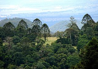
Bunya Mountains is a national park in the South Burnett Region, Queensland, Australia.

Cape Palmerston is a national park in the Mackay Region, Queensland, Australia.
Cliff Island is a national park at Yarraden on Cape York Peninsula in Far North Queensland, Australia, 1,757 km northwest of Brisbane. It is part of the Great Barrier Reef Marine Park west of Cape Melville in Princess Charlotte Bay. The park is a restricted access area in order to protect cultural resource of the islands traditional owners, the Lama Lama people.

Hasties Swamp is a national park in Queensland, Australia, 1,371 km northwest of Brisbane. The swamp is located several kilometres south of the town of Atherton in Far North Queensland. The main feature of the park is a seasonal wetland. Part of the swamp was first declared a national park on 5 April 1980.

The Jardine River National Park is a national park in Queensland, Australia, 2,137 km (1,328 mi) northwest of Brisbane and about 900 km (559 mi) northwest of Cairns, on the tip of Cape York Peninsula.

Oyala Thumotang, formerly Mungkan Kandju National Park, is a national park in Queensland, Australia, 1,914 kilometres (1,189 mi) northwest of Brisbane.

Cape York Peninsula is a large peninsula located in Far North Queensland, Australia. It is the largest unspoiled wilderness in northern Australia. The land is mostly flat and about half of the area is used for grazing cattle. The relatively undisturbed eucalyptus-wooded savannahs, tropical rainforests and other types of habitat are now recognized and preserved for their global environmental significance. Although much of the peninsula remains pristine, with a diverse repertoire of endemic flora and fauna, some of its wildlife may be threatened by industry and overgrazing as well as introduced species and weeds.

Central Queensland is an ambiguous geographical division of Queensland that centres on the eastern coast, around the Tropic of Capricorn. Its major regional centre is Rockhampton. The region extends from the Capricorn Coast west to the Central Highlands at Emerald, north to the Mackay Regional Council southern boundary, and south to Gladstone. The region is also known as Capricornia. It is one of Australia's main coal exporting regions.

The Staaten River is a river in northern Queensland, Australia, rising in the Great Dividing Range and flowing northwest into the Gulf of Carpentaria.

Cape Grenville, is a small, east-facing promontory along the Queensland, Australia coast of Cape York Peninsula. It lies between Shelburne Bay to the north and Temple Bay to the south. The nearest significant settlement is Weipa, along the western coast of Cape York.

An Indigenous Protected Area (IPA) is a class of protected area used in Australia; each is formed by agreement with Indigenous Australians, and declared by Indigenous Australians. Each is formally recognised by the Australian Government as being part of its National Reserve System, with 75 IPAs comprising more than 44% of the national reserve land, occupying about 67,000,000 hectares as of April 2020.
The Moreton Bay Marine Park was established in 1992 to protect ecologically significant habitats in Moreton Bay. The marine park extends from Caloundra south to the southern tip of South Stradbroke Island. The marine park's border extends up to the highest tidal mark and covers a total of 3,400 km2.

The Jardine River is the largest river of the Cape York Peninsula in Far North Queensland, Australia.
The Archer River is a river located on the Cape York Peninsula, Far North Queensland, Australia.

Lake Newland Conservation Park is a protected area in the Australian state of South Australia located on the west coast of the Eyre Peninsula about 10 kilometres (6.2 mi) north of the town of Elliston. It was proclaimed in 1991 in order to protect Lake Newland, a hypersaline lake, and an associated wetland complex. It lies in the traditional lands of the Wirangu people.
Alwal National Park is a national park in the Shire of Cook on the Cape York Peninsula in Far North Queensland, Australia.
Annan River National Park is a national park on Cape York Peninsula in Far North Queensland, Australia. The Annan River from which the park gets its name, marks the northern and western extent of the park. To the east of the park is Walker Bay in the Coral Sea. The park was gazetted in 2006.

The Mossman River is a river located in the Cape York Peninsula of Far North Queensland, Australia.

