Queensland is the second largest state in Australia. It contains around 500 separate protected areas. In August 2023, it was estimated a total of 14.5 million hectares or 8.38% of Queensland's landmass was protected.

Kalkajaka National Park is a 781-hectare (1,930-acre) protected area in Shire of Cook, Queensland, Australia.

Bribie Island National Park is an Australian national park in the City of Moreton Bay, Queensland, 68 kilometres north of Brisbane. The park covers approximately one third of Bribie Island. The tidal wetlands and areas of water around the islands are protected within the Moreton Bay Marine Park.
Marpa is a national park at Yarraden on Cape York Peninsula in Far North Queensland, Australia, 1,757 km northwest of Brisbane. It is part of the Great Barrier Reef Marine Park west of Cape Melville in Princess Charlotte Bay. The park is a restricted access area in order to protect cultural resource of the islands traditional owners, the Lama Lama people.
Dryander is a national park in Queensland (Australia), 938 km northwest of Brisbane, and north of Proserpine. The most prominent mountain in the park is Mount Drylander and rises to 765 meters above sea level.

Endeavour River National Park is a national park in Queensland, Australia, gazetted to protect and preserve some of the natural and cultural resources in and around the mouth of the Endeavour River, immediately north of the small town of Cooktown. The park is located 1,561 kilometres (970 mi) northwest of Brisbane.

Moreton Island (Mulgumpin) is an island on the eastern side of Moreton Bay on the coast of South East Queensland, Australia. The Coral Sea lies on the east coast of the island. Moreton Island lies 58 kilometres (36 mi) northeast of the Queensland capital, Brisbane. 98% of the island is contained within a national park and a popular destination for day trippers, four wheel driving, camping, recreational angling and whale watching and a 75-minute ferry ride from Brisbane. It is the third largest sand island in the world. Together with Fraser Island, Moreton Island forms the largest sand structure in the world. It was the traditional country of the Ngugi before settlement.

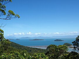
The Wet Tropics of Queensland World Heritage Site consists of approximately 8,940 km2 of Australian wet tropical forests growing along the north-east Queensland portion of the Great Dividing Range. The Wet Tropics of Queensland meets all four of the criteria for natural heritage for selection as a World Heritage Site. World Heritage status was declared in 1988, and on 21 May 2007 the Wet Tropics were added to the Australian National Heritage List.

Hinchinbrook Island is an island in the Cassowary Coast Region, Queensland, Australia. It lies east of Cardwell and north of Lucinda, separated from the north-eastern coast of Queensland by the narrow Hinchinbrook Channel. Hinchinbrook Island is part of the Great Barrier Reef Marine Park and wholly protected within the Hinchinbrook Island National Park, except for a small and abandoned resort. It is the largest island on the Great Barrier Reef. It is also the largest island national park in Australia.

Dunk Island, known as Coonanglebah in the Warrgamay and Dyirbal languages, is an island within the locality of Dunk in the Cassowary Coast Region, Queensland, Australia. It lies 4 kilometres (2.5 mi) off the Australian east coast, opposite the town of Mission Beach. The island forms part of the Family Islands National Park and is in the larger Great Barrier Reef World Heritage Area.

Whitsunday Island is the largest island in the Whitsunday group of islands located off the coast of Central Queensland, Australia.
Wheeler Island is one of the middle islands of the Family Islands group within the locality of Dunk in the Cassowary Coast Region, Queensland. Australia. It is located approximately 15 km East of Tully Heads. The Aboriginal name for this island is Toolgbar.

Bedarra Island is one of the Family Islands group within the locality of Dunk in the Cassowary Coast Region, Queensland. Australia.
Thorpe Island is one of the middle islands of the Family Islands group within the locality of Dunk in the Cassowary Coast Region, Queensland. Australia. It is about 15 km east of Tully Heads. It is also known as Timana Island.
Kumboola Island is in the Family Islands group and located approximately 15 km North East of Tully Heads and immediately south of Dunk Island. It is part of the Family Islands National Park. It is around 6 hectares or 0.06 square km in size.
Kent Island is an island in the Australian state of Queensland located about 80 km North of Dunk Island and east of the Cowley Beach Training area and north of the South Barnard Islands. North west of Kent Island is Jessie Island, Hutchinson Island and Bresnahan Island.

A resort island is a hotel complex located on an island; in many cases one luxury hotel may own the entire island. More broadly, resort island can be defined as any island or an archipelago that contains resorts, hotels, overwater bungalows, restaurants, tourist attractions and its amenities, and might offer all-inclusive accommodations. It primary focus on tourism services and offer leisure, adventure, and amusement opportunities.

Ninney Rise and John Busst Memorial are a heritage-listed house and memorial at 405 Alexander Drive and Esplanade, Bingil Bay, Cassowary Coast Region, Queensland, Australia. It was designed by John Busst and built circa 1960 by John Busst. It is also known as John and Alison Busst's Residence. It was added to the Queensland Heritage Register on 6 August 2010.
Woodwark is a coastal locality in the Whitsunday Region, Queensland, Australia. In the 2016 census, Woodwark had a population of 374 people.
Dunk is a locality consisting of the Family Islands in the Coral Sea within the Cassowary Coast Region, Queensland, Australia. In the 2016 census, Dunk had a population of 21 people.