
The Oxley Wild Rivers National Park is a protected national park that is located in the Northern Tablelands region of New South Wales, Australia in the Port Macquarie-Hastings City Council and Walcha Shire councils. The 145,223-hectare (358,850-acre) park is situated 445 kilometres (277 mi) north of Sydney and is named in memory of the Australian explorer John Oxley, who passed through the area in 1818 and is one of the largest national parks in New South Wales.

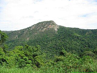
Auburn River National Park is a protected area in the North Burnett Region, Queensland, Australia. It is in the north-east of the locality of Hawkwood extending into southern Dykehead.
Barron Gorge National Park is a protected area in the Cairns Region, Queensland, Australia. It is predominantly within the locality of Barron Gorge.

Blackdown Tableland is a national park in the Central Highlands Region, Queensland, Australia.

Kondalilla is a national park in the Blackall Range of South East Queensland, Australia, 91 km north of Brisbane. William Skene founded this area on his property while searching for lost cattle. He named it Bon Accord before giving it to the Queensland Government who, during the fifties, renamed it Kondalilla which is an Aboriginal word for running water. The area was first officially protected in 1906 as a recreational area, becoming a national park in 1945.

Kroombit Tops is a national park in Central Queensland, Australia. It is between Monto and Calliope. It is two parts. The largest part is within the localities of Tablelands, Valentine Plains, Cania and Boyne Valley, while the smaller part is in the locality of Mount Alma. It is 399 km northwest of Brisbane. Cania Gorge National Park is located approximately 25 km to the south.

The Lamington National Park is a national park, lying on the Lamington Plateau of the McPherson Range on the Queensland/New South Wales border in Australia. From Southport on the Gold Coast the park is 85 kilometres (53 mi) to the southwest and Brisbane is 110 kilometres (68 mi) north. The 20,600 hectares Lamington National Park is known for its natural environment, rainforests, birdlife, ancient trees, waterfalls, walking tracks and mountain views.

Boodjamulla National Park, formerly known as Lawn Hill National Park, is a national park in the Shire of Burke, Queensland, Australia. The Riversleigh World Heritage Area is a World Heritage Site within the park.

Mount Walsh is a national park in Queensland, Australia, 230 km northwest of Brisbane.

The Springbrook National Park is a protected national park that is located in the Gold Coast hinterland of Queensland, Australia. The 6,197-hectare (15,310-acre) park is situated on the McPherson Range, near Springbrook, approximately 100 kilometres (62 mi) south of Brisbane. The park is part of the Shield Volcano Group of the UNESCO World Heritage–listed Gondwana Rainforests of Australia.

Tamborine is a national park in the Gold Coast hinterland and is a part of the Scenic Rim Regional Council of South East Queensland, Australia, 45 km (28 mi) south of Brisbane.

The Blue Ridge Parkway is a National Parkway and All-American Road in the United States, noted for its scenic beauty. The parkway, which is America's longest linear park, runs for 469 miles (755 km) through 29 Virginia and North Carolina counties, linking Shenandoah National Park to Great Smoky Mountains National Park. It runs mostly along the spine of the Blue Ridge, a major mountain chain that is part of the Appalachian Mountains. Its southern terminus is at U.S. Route 441 (US 441) on the boundary between Great Smoky Mountains National Park and the Cherokee Indian Reservation in North Carolina, from which it travels north to Shenandoah National Park in Virginia. The roadway continues through Shenandoah as Skyline Drive, a similar scenic road which is managed by a different National Park Service unit. Both Skyline Drive and the Virginia portion of the Blue Ridge Parkway are part of Virginia State Route 48 (SR 48), though this designation is not signed.

The Burnett River is a river located in the Wide Bay–Burnett and Central Queensland regions of Queensland, Australia.

Monto is a rural town and locality in the North Burnett Region, Queensland, Australia. In the 2016 census, Monto had a population of 1,189 people.

Carnarvon Gorge is located in the Southern Brigalow Belt bioregion in Central Queensland (Australia), 593 km northwest of Brisbane. Primarily created by water erosion, Carnarvon Gorge is around 30 kilometres long, located in Carnarvon National Park, and six hundred metres deep at the mouth. It is the most visited feature within Carnarvon National Park due to the diversity of experiences it contains and the ease with which it can be accessed. The closest towns are Injune and Rolleston.

Goomeri is a town and locality in the Gympie Region, Queensland, Australia. In the 2016 census, Goomeri had a population of 664 people.
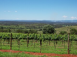
The South Burnett is a peanut growing and wine-producing area on the Great Dividing Range, north of the Darling Downs, in Queensland. It is with the basin of the Burnett River. The area is within two local government areas, South Burnett Region and Gympie Region.

Moonford is a town and locality in the North Burnett Region, Queensland, Australia.

Cania is a locality in the North Burnett Region, Queensland, Australia. In the 2016 census, Cania had a population of 28 people.

Babinda Boulders, officially called the Boulders Scenic Reserve but known locally as Babinda Boulders or simply the Boulders, is a public recreation reserve managed by the Cairns Regional Council and adjacent to the Wooroonooran National Park in far north Queensland, Australia.


