
The Coral Sea Islands Territory is an external territory of Australia which comprises a group of small and mostly uninhabited tropical islands and reefs in the Coral Sea, northeast of Queensland, Australia. The only inhabited island is Willis Island. The territory covers 780,000 km2 (301,160 sq mi), most of which is ocean, extending east and south from the outer edge of the Great Barrier Reef and includes Heralds Beacon Island, Osprey Reef, the Willis Group and fifteen other reef/island groups. Cato Island is the highest point in the Territory.
The Great Barrier Reef Marine Park protects a large part of Australia's Great Barrier Reef from damaging activities. It is a vast multiple-use Marine Park which supports a wide range of uses, including commercial marine tourism, fishing, ports and shipping, recreation, scientific research and Indigenous traditional use. Fishing and the removal of artefacts or wildlife is strictly regulated, and commercial shipping traffic must stick to certain specific defined shipping routes that avoid the most sensitive areas of the park. The Great Barrier Reef is the largest and best known coral reef ecosystem in the world. Its reefs, almost 3000 in total, represent about 10 per cent of all the coral reef areas in the world. It supports an amazing variety of biodiversity, providing a home to thousands of coral and other invertebrate species, bony fish, sharks, rays, marine mammals, marine turtles, sea snakes, as well as algae and other marine plants.
Hinchinbrook Island National Park is situated along the Cassowary Coast Queensland, Australia. The nearest capital city is Brisbane approximately 1240 Lucinda is 135km or 1.5 hours drive north of Townsville being the closest North Queensland provincial city. Cairns a Far North Queensland provincial city is two and a half to 3 hours drive north from Cardwell. The main geographical features in the park are the rugged Hinchinbrook Island, including Mount Bowen.

Mount Coolum is a mountain in a national park in a suburb of the same name in Queensland, Australia. Mount Coolum is located on the Sunshine Coast, 101 km north of Brisbane. It lies between the Sunshine Motorway to the west, the shoreline to the east, Coolum Beach township to the north and Marcoola township to the south.

Orpheus Island is a national park in North Queensland, Australia, 1,189 km (739 mi) northwest of Brisbane, as is Pelorus Island 800 metres to the north. It is part of Shire of Hinchinbrook. Besides Orpheus Island, the national park also includes Albino Rock, which is located 2.6 kilometres (1.6 mi) east of Palm Island. Palm Island is the closest location with government facilities. A research station, operated by James Cook University, is located on the island, as is an exclusive resort. St Michael's Grammar School uses it for a two-week program known as GBR each June. Orpheus Island is a continental island. At the census of population 2006, Orpheus had a population of 21, no families.

Rocky Islets are part of the Three Islands National Park in Far North Queensland, Australia, in the Coral Sea, 1605 km northwest of Brisbane.
South Island is a national park in North Queensland (Australia), 692 km northwest of Brisbane and the island is part of the Lizard Island Group and is South of Lizard Island situated 270 km north of Cairns, Queensland.

Three Islands and Three Islands Reef are part of the Three Islands Group National Park in Far North Queensland, Australia, in the Coral Sea, 1,581 km (982 mi) northwest of Brisbane, about 44 km (27 mi) north-northeast of Cooktown.
Topaz Road is a national park in Far North Queensland, Australia, 1,348 km northwest of Brisbane. It covers an area of 0.4 km². According to the Queensland Government, "Topaz Road National Park protects remnant rainforest in the upper Johnstone River catchment. The park and nearby nature refuges form a network of protected areas that adjoin Wooroonooran National Park, providing habitat connectivity for a wide variety of Wet Tropics species."

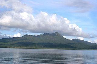
Hinchinbrook Island lies east of Cardwell and north of Lucinda, separated from the northern coast of Queensland, Australia by the narrow Hinchinbrook Channel. Hinchinbrook Island is part of the Great Barrier Reef Marine Park and wholly protected within the Hinchinbrook Island National Park, except for a small and abandoned resort. It is the largest island on the Great Barrier Reef. It is also the largest island national park in Australia.
Low Island North Queensland is about 25 km (16 mi) north-east of Port Douglas in Trinity Bay, North Queensland. It is around 2 hectares or 0.02 square km in size.
Eagle Island is in a national park in Queensland, Australia, 692 km north-west of Brisbane. The island is part of the Lizard Island Group and is south of Lizard Island situated 270 km north of Cairns, Queensland.
Sherrard Island is an island in the Aboriginal Shire of Lockhart River in Queensland, Australia.

Ella Bay is a bay located in the Cassowary Coast Region in Far North Queensland, Australia. It is within close proximity to the town of Innisfail. Innisfail is situated 88 kilometres (55 mi) south of Cairns and 260 kilometres (160 mi) north of Townsville. The bay is bounded by Cooper's point in the north and Heath's point in the south. The land area adjacent to Ella Bay is named Wanjuru, however this name is not commonly used and the name Ella Bay can refer to this land area as well.
Cooloola is a locality in the Gympie Region, Queensland, Australia. The 2011 census recorded Cooloola's population currently stands at 0.
Great Palm Island, also known as Palm Island, or by the Aboriginal name Bwgcolman; is a tropical island with a resident community of about 2,000 people. The island has an area of 55 km2 (21 sq mi). The official area figure of 70.9 km² refers to Aboriginal Shire of Palm Island and includes nine smaller islands. It is in Queensland, Australia, off the east coast of northern Queensland, situated 65 kilometres (40 mi) northwest of Townsville, and 800 kilometres (500 mi) north of the Tropic of Capricorn. The Australia Post lists the local post office as Palm Island, QLD. It is the main island of the Greater Palm group, and consists of small bays, sandy beaches and steep forested mountains rising to a peak of 548 metres (1,798 ft). The ocean surrounding the island is part of the Great Barrier Reef Marine Park where extraction and fishing are regulated.

Creal Reef Light is an active lighthouse located at Creal Reef, a planar reef about 150 kilometres (93 mi) east of Mackay, Queensland, Australia. It guides ships outgoing from Mackay into Hydrographers Passage, a deep water channel east of Mackay. The structure is a stainless steel tower, which also serves as a daymark and carries a racon.

North Reef Light is an active lighthouse located on North Reef, a 5.6 square kilometres (2.2 sq mi) planar reef, about 120 kilometres (75 mi) northeast of Gladstone, Queensland, Australia in the Capricorn and Bunker Group. The lighthouse was constructed on a migratory patch of sand inside a fringing coral reef, which over the years disappeared and reappeared, as sand was washed away and accumulated, and is now a vegetated sandy island. Its construction is unique, having a hollow concrete base that both gives it resistance to the shifting nature of the sandbar and serves as a fresh water tank. As such, it is considered one of the major achievement in Australian lighthouse construction. It is also notable in that due to the harsh conditions, only bachelors were allowed to serve as lighthouse keepers. At 24 metres (79 ft) it is also the tallest of Queensland's timber framed iron clad lighthouses.

Wyborn Reef Light is an active lighthouse located at Wyborn Reef, formerly known as Y Reef, about 16 kilometres (9.9 mi) southeast of Albany Island, east of the tip of Cape York Peninsula, Queensland, Australia. It marks the entrance to the Albany Passage. The lighthouse was constructed in 1938 and upgraded in 1991 and 1995. The structure is a stainless steel tower with a fiberglass hut within the framework, carrying a lantern.
Australian marine parks are marine protected areas located within Australian waters and are managed by the Australian government. These waters generally extend from three nautical miles off the coast to the outer limit of Australia’s Exclusive Economic Zone at 200 nautical miles while marine protected areas located closer in-shore are the responsibility of the states or the Northern Territory.


