Undara Volcanic National Park

Last updated

Undara Volcanic National Park
Queensland
Undara Lava Tubes - panoramio (11).jpg
Undara Lava Tubes
Australia Queensland location map.svg
Red pog.svg
Undara Volcanic National Park
Nearest town or city Mount Surprise, Queensland
Coordinates 18°12′4″S144°35′46″E / 18.20111°S 144.59611°E / -18.20111; 144.59611
Established1993
Area615 km²
Managing authorities Queensland Parks and Wildlife Service
See also Protected areas of Queensland
Undara Lava Tubes Undara Lava Tubes.JPG
Undara Lava Tubes

The Undara Volcanic National Park is a national park in the Shire of Etheridge, Queensland, Australia. [1] It is situated 275 kilometres southwest of Cairns just off the Gulf Developmental Road. The park was established in 2009 to protect Australia's longest lava tube and the unique fauna and flora found of the area. The basalts of the area form part of the Cenozoic McBride Basalt (Volcanic) Provence. The volcanics are all less than 8 million years old (Ma) with the youngest only 7,000 years old.

Contents

Location

The Undara Volcanic National Park is situated 437 km northwest of Townsville and 275 km southwest of Cairns, the two major regional centres of North Queensland. The National Park is 58 kilometres by road from the small town of Mount Surprise. The National Park is approximately 61,500 hectares in area. The climate is monsoonal and is generally hot and humid. It can be very wet from October to late March. The drier cooler months are April to August.

The Queensland Department of Environment and Science consider much of the park dangerous for unguided visitors because of a combination of concealed holes where lava tubes have collapsed, high carbon dioxide in some of the tubes and a confusing landscape. As such visits to the tubes is by guide only. The Kalkani Crater is accessible without a guide. [2]

History

Undara is an Aboriginal word for 'a long way'. [3] The Ewamian (pronounced your-amin) Aboriginal people are the traditional owners of the national park. [4]

European people moved into the area in the 1860s and prior the national park being declared the area was used for cattle grazing. The lava tubes were well recognised by 1891 and had unmanaged intermittent visits. Guided tours commenced in 1989. [5] [6]

Prior to the formation of the national park the area was owned by the Collins Family who settled in the region in 1862. The family had developed infrastructure (known now as the Undara Experience) before the park formation and they were given a special business lease to continue the tourist operation after the national park was declared. [7]

In 2009 as part of the Q150 celebrations, the Undara Volcanic National Park was announced as one of the Q150 Icons of Queensland for its role as a "Natural attraction". [8] The park management plan has a focus of protecting the geological values and enhancing visitor service and facilities. [5]

Geology

The Undara Volcanic National Park lies within the McBride Basalt (Volcanic) Province [9] which is one of 11 discontinuous Cenozoic volcanic regions in north Queensland. The McBride Basalt Province is around 5,500 km2 in area. [10]

Geological sketch map of the Undara National Park formations. Undara National Park3.jpg
Geological sketch map of the Undara National Park formations.

A total of 164 eruption centres (volcanoes, vents and cones) have been identified within the McBride Basalt Province. Remnants of older flows dated at around 8 Ma occur outside of the national park. The majority of flows are less than 8 Ma. [11] [10] The volcanic activity that formed the tubes occurred approximately 190,000 years ago [11] [12] and the Undara volcano expelled massive amounts of lava onto the surrounding Atherton Tableland, covering about 1550 square kilometres. [11] In total it was estimated that over 23 billion cubic metres of lava was released. [6]

Thermal insulation provided by the solidification of a crust above actively flowing magma is required to produce long lava flows. The longest of the Undara flows is approximately 160 km with an average gradient of 0.3°. Lava tubes occur up to 30 km from the Undara Crater and up to 5 successive flow units, demarcated by Pahoehoe surfaces, have been identified in the walls of some of the caves. [10]

Bayliss Cave is the remains of a lava tube that was once over 100 kilometres (62 mi) in length. The cave itself is over 1,300 metres (4,265 ft) in length, 11 metres (36 ft) high and 22 metres (72 ft) wide. It is described as a "bad air cave" with measured carbon dioxide levels as high as 5.9%. [13]

Fauna and flora

The Queensland Department of Environment and Science have recognised more than 120 species of bird including the vulnerable Red Goshawk. [2] E-bird has recorded 132 species at Undara Experience just on the northern edge of the park. [14]

Undara Volcanic National Park is home to four insectivorous or micro bats; the Bent-wing Bat, the Eastern Cave Bat, the Northern Horseshoe Bat (alternative name: Eastern Horseshoe Bat) and the Coastal Sheath-tailed Bat. [15] The large number of bats provide food for various snakes and birds of prey. Bayllis Cave is one of the world’s most biologically diverse caves. The cave has recorded 52 resident species including the most diverse assemblage of arthropods found in a north Queensland Cave. [2]

The national park is also home to a wide range of macroropods including the Common Wallaroos, the Antilopine Wallaroo and the Northern Quoll. [2]

Much of the national park is dry savanna woodland but the lava tubes and collapse areas now provide an environment for other vegetation to flourish in the damp interiors. The lava tubes show up as rich green vine thickets that have strong affinities with Gondwana species. The rare white-flowered onion vine occurs within the park's vine thickets. [2]

See also

Related Research Articles

<span class="mw-page-title-main">Rangitoto Island</span> Island in New Zealand

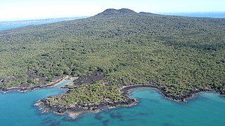
Rangitoto Island is a volcanic island in the Hauraki Gulf near Auckland, New Zealand. The 5.5 km (3.4 mi) wide island is a symmetrical shield volcano cone capped by central scoria cones, reaching a height of 260 m (850 ft). Rangitoto is the youngest and largest of the approximately 50 volcanoes of the Auckland volcanic field, having erupted in two phases about 1450 CE and 1500 CE and covering an area of 2,311 ha. It is separated from the mainland of Auckland's North Shore by the Rangitoto Channel. Since World War II, it has been linked by a causeway to the much older, non-volcanic Motutapu Island.

<span class="mw-page-title-main">Lava Beds National Monument</span> National monument in California, United States

Lava Beds National Monument is located in northeastern California, in Siskiyou and Modoc counties. The monument lies on the northeastern flank of Medicine Lake Volcano, which is the largest volcano by area in the Cascade Range.

<span class="mw-page-title-main">Craters of the Moon National Monument and Preserve</span> National monument in Idaho, United States

Craters of the Moon National Monument and Preserve is a U.S. national monument and national preserve in the Snake River Plain in central Idaho. It is along US 20, between the small towns of Arco and Carey, at an average elevation of 5,900 feet (1,800 m) above sea level.

<span class="mw-page-title-main">Shield volcano</span> Low-profile volcano usually formed almost entirely of fluid lava flows

A shield volcano is a type of volcano named for its low profile, resembling a shield lying on the ground. It is formed by the eruption of highly fluid lava, which travels farther and forms thinner flows than the more viscous lava erupted from a stratovolcano. Repeated eruptions result in the steady accumulation of broad sheets of lava, building up the shield volcano's distinctive form.

<span class="mw-page-title-main">Lassen Volcanic National Park</span> National park in California, United States

Lassen Volcanic National Park is an American national park in northeastern California. The dominant feature of the park is Lassen Peak, the largest plug dome volcano in the world and the southernmost volcano in the Cascade Range. Lassen Volcanic National Park is one of the few areas in the world where all four types of volcano can be found—plug dome, shield, cinder cone, and stratovolcano.

<span class="mw-page-title-main">Mount Mazama</span> Complex volcano in the Cascade Range

Mount Mazama is a complex volcano in the western U.S. state of Oregon, in a segment of the Cascade Volcanic Arc and Cascade Range. Most of the mountain collapsed following a major eruption approximately 7,700 years ago. The volcano is in Klamath County, in the southern Cascades, 60 miles (97 km) north of the Oregon–California border. Its collapse, due to the eruption of magma emptying the underlying magma chamber, formed a caldera that holds Crater Lake. The mountain is in Crater Lake National Park. Mount Mazama originally had an elevation of 12,000 feet (3,700 m), but following its climactic eruption this was reduced to 8,157 feet (2,486 m). Crater Lake is 1,943 feet (592 m) deep, the deepest freshwater body in the U.S. and the second deepest in North America after Great Slave Lake in Canada.

<span class="mw-page-title-main">Belknap Crater</span> Shield volcano in the U.S. state of Oregon

Belknap Crater is a shield volcano in the Cascade Range in the U.S. state of Oregon. Located in Linn County, it is associated with lava fields and numerous subfeatures including the Little Belknap and South Belknap volcanic cones. It lies north of McKenzie Pass and forms part of the Mount Washington Wilderness. Belknap is not forested and most of its lava flows are not vegetated, though there is some wildlife in the area around the volcano, as well as a number of tree molds formed by its eruptive activity.

<span class="mw-page-title-main">Snæfellsjökull</span> Stratovolcano in Iceland

Snæfellsjökull is a 700,000-year-old glacier-capped stratovolcano in western Iceland. It is situated on the westernmost part of the Snæfellsnes peninsula. Sometimes it may be seen from the city of Reykjavík over Faxa Bay, at a distance of 120 km (75 mi).

<span class="mw-page-title-main">San Francisco volcanic field</span> Part of the San Francisco Peaks in northern Arizona

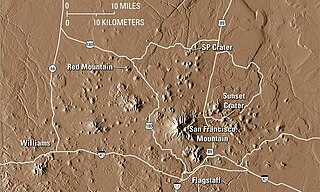
The San Francisco volcanic field is an area of volcanoes in northern Arizona, north of Flagstaff, US. The field covers 1,800 square miles (4,700 km²) of the southern boundary of the Colorado Plateau. The field contains 600 volcanoes ranging in age from nearly 6 million years old to less than 1,000 years, of which Sunset Crater is the youngest. The highest peak in the field is Humphreys Peak, at Flagstaff's northern perimeter: the peak is Arizona's highest at 12,633 feet and is a part of the San Francisco Peaks, an active stratovolcano complex.

<span class="mw-page-title-main">Auckland volcanic field</span> Volcanic field in New Zealand

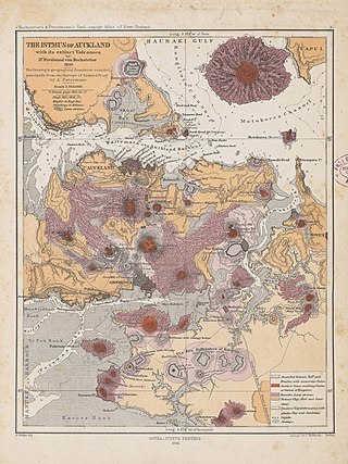
The Auckland volcanic field is an area of monogenetic volcanoes covered by much of the metropolitan area of Auckland, New Zealand's largest city, located in the North Island. The approximately 53 volcanoes in the field have produced a diverse array of maars, tuff rings, scoria cones, and lava flows. With the exception of Rangitoto, no volcano has erupted more than once, but the other eruptions lasted for various periods ranging from a few weeks to several years. Rangitoto erupted several times and recently twice; in an eruption that occurred about 600 years ago, followed by a second eruption approximately 50 years later. The field is fuelled entirely by basaltic magma, unlike the explosive subduction-driven volcanism in the central North Island, such as at Mount Ruapehu and Lake Taupō.

<span class="mw-page-title-main">Masaya Volcano</span> Active complex volcano in Nicaragua

Masaya is a caldera located in Masaya, Nicaragua, 20 km (12 mi) south of the capital Managua. It is Nicaragua's first and largest national park, and one of 78 protected areas of Nicaragua. The complex volcano is composed of a nested set of calderas and craters, the largest of which is Las Sierras shield volcano and caldera. Within this caldera lies a sub-vent, which is Masaya Volcano sensu stricto. The vent is a shield type composing of basaltic lavas and tephras and includes a summit crater. This hosts Masaya caldera, formed 2,500 years ago by an 8 km3 (1.9 cu mi) basaltic ignimbrite eruption. Inside this caldera a new basaltic complex has grown from eruptions mainly on a semi-circular set of vents that include the Masaya and Nindiri cones. The latter host the pit craters of Masaya, Santiago, Nindiri and San Pedro. Observations in the walls of the pit craters indicate that there have been several episodes of cone and pit crater formation.

<span class="mw-page-title-main">Pisgah Crater</span> Volcanic cinder cone in San Bernardino County, California, United States

Pisgah Crater, or Pisgah Volcano, is a young volcanic cinder cone rising above a lava plain in the Mojave Desert, between Barstow and Needles, California in San Bernardino County, California. The volcanic peak is around 2.5 miles (4.0 km) south of historic U.S. Route 66-National Old Trails Highway and of Interstate 40, and west of the town of Ludlow. The volcano had a historic elevation of 2,638 feet (804 m), but has been reduced to 2,545 feet (776 m) due to mining.

<span class="mw-page-title-main">El Malpais National Monument</span> National monument in New Mexico, United States

El Malpais National Monument is a National Monument located in western New Mexico, in the Southwestern United States. The name El Malpais is from the Spanish term Malpaís, meaning badlands, due to the extremely barren and dramatic volcanic field that covers much of the park's area.

<span class="mw-page-title-main">Black Crater</span> Shield volcano in central Oregon, United States

Black Crater is a shield volcano in the Western Cascades in Deschutes County, Oregon. Located near McKenzie Pass, the volcano has a broad conical shape with gentle slopes. The volcano likely formed during the Pleistocene and has not been active within the last 50,000 years. Eruptive activity at the volcano produced mafic lava flows made of basaltic andesite and olivine basalt; it also formed a number of cinder cones. A normal fault occurs on the western side of the volcano, trending north–south. The volcano has been eroded by glaciers, which carved a large cirque into the northeastern flank of the mountain, forming its current crater.

<span class="mw-page-title-main">Zuni-Bandera volcanic field</span> Volcanic field in New Mexico, United States

Zuni-Bandera volcanic field is a volcanic field located in the state of New Mexico, United States.

<span class="mw-page-title-main">Lava cave</span> Cave formed in volcanic rock, especially one formed via volcanic processes

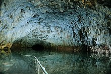
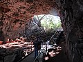
A lava cave is any cave formed in volcanic rock, though it typically means caves formed by volcanic processes, which are more properly termed volcanic caves. Sea caves, and other sorts of erosional and crevice caves, may be formed in volcanic rocks, but through non-volcanic processes and usually long after the volcanic rock was emplaced.

<span class="mw-page-title-main">Volcanic history of the Northern Cordilleran Volcanic Province</span>

The volcanic history of the Northern Cordilleran Volcanic Province presents a record of volcanic activity in northwestern British Columbia, central Yukon and the U.S. state of easternmost Alaska. The volcanic activity lies in the northern part of the Western Cordillera of the Pacific Northwest region of North America. Extensional cracking of the North American Plate in this part of North America has existed for millions of years. Continuation of this continental rifting has fed scores of volcanoes throughout the Northern Cordilleran Volcanic Province over at least the past 20 million years and occasionally continued into geologically recent times.

<span class="mw-page-title-main">Einasleigh Uplands</span> Bioregion in Queensland, Australia

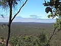
The Einasleigh Uplands is an interim Australian bioregion, with vegetation consisting of savanna and woodland located on a large plateau in inland Queensland, Australia. It corresponds to the Einasleigh Uplands savanna ecoregion, as identified by the World Wildlife Fund.

<span class="mw-page-title-main">Volcanism on the Moon</span> Volcanic processes and landforms on the Moon

Volcanism on the Moon is represented by the presence of volcanoes, pyroclastic deposits and vast lava plains on the lunar surface. The volcanoes are typically in the form of small domes and cones that form large volcanic complexes and isolated edifices. Calderas, large-scale collapse features generally formed late in a volcanic eruptive episode, are exceptionally rare on the Moon. Lunar pyroclastic deposits are the result of lava fountain eruptions from volatile-laden basaltic magmas rapidly ascending from deep mantle sources and erupting as a spray of magma, forming tiny glass beads. However, pyroclastic deposits formed by less common non-basaltic explosive eruptions are also thought to exist on the Moon. Lunar lava plains cover large swaths of the Moon's surface and consist mainly of voluminous basaltic flows. They contain a number of volcanic features related to the cooling of lava, including lava tubes, rilles and wrinkle ridges.

References

  1. "Undara Volcanic National Park – national park in the Shire of Etheridge (entry 51389)". Queensland Place Names. Queensland Government . Retrieved 30 July 2021.
  2. 1 2 3 4 5 Science (19 October 2009). "Undara Volcanic National Park - Nature, culture and history". Department of Environment and Science. Archived from the original on 27 March 2020. Retrieved 27 March 2020.
  3. "Undara Volcanic National Park". austhrutime.com. Archived from the original on 28 July 2019. Retrieved 27 March 2020.
  4. "Ewamian Aboriginal Corporation | Our Country Our Culture". Ewamian. Archived from the original on 27 March 2020. Retrieved 27 March 2020.
  5. 1 2 Queensland Parks and Wildlife Service (September 1999). "Undara Volcanic and Forty Mile Scrub National Parks Management Plan" (PDF). Queensland Government, Department of Environment and Science, Parks and Forests. Archived (PDF) from the original on 13 April 2019. Retrieved 27 March 2020.
  6. 1 2 "Undara Experience". Savannah Guides. Archived from the original on 27 March 2020. Retrieved 27 March 2020.
  7. "The Collins Family History - Owners of Undara Experience". Undara. Archived from the original on 27 March 2020. Retrieved 27 March 2020.
  8. Bligh, Anna (10 June 2009). "PREMIER UNVEILS QUEENSLAND'S 150 ICONS". Queensland Government. Archived from the original on 24 May 2017. Retrieved 24 May 2017.
  9. "Global Volcanism Program | McBride Volcanic Province". Smithsonian Institution | Global Volcanism Program. Archived from the original on 12 February 2020. Retrieved 27 March 2020.
  10. 1 2 3 Whitehead, Peter (12 August 2010). "The Regional Context of the McBride Basalt Province and the Formation of the Undara Lava Flows, Tubes, Rises and Depressions".{{cite journal}}: Cite journal requires |journal= (help)
  11. 1 2 3 Cohen, Benjamin E.; Mark, Darren F.; Fallon, Stewart J.; Stephenson, P. Jon (1 April 2017). "Holocene-Neogene volcanism in northeastern Australia: Chronology and eruption history" (PDF). Quaternary Geochronology. 39: 79–91. doi:10.1016/j.quageo.2017.01.003. ISSN   1871-1014 . Retrieved 26 December 2020.
  12. "Undara | Volcano World | Oregon State University". volcano.oregonstate.edu. Archived from the original on 31 July 2019. Retrieved 27 March 2020.
  13. "Undara Volcanic National Park - Tunnels to the Underworld". 2010. Archived from the original on 16 September 2010. Retrieved 23 August 2010.
  14. "Explore Hotspots - eBird: Undara Experience". ebird.org. Archived from the original on 18 February 2023. Retrieved 27 March 2020.
  15. "Welcome to All About Bats". All About Bats. Archived from the original on 27 March 2020. Retrieved 27 March 2020.

Commons-logo.svg Media related to Undara Volcanic National Park at Wikimedia Commons