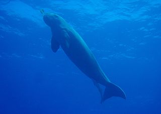
The dugong is a marine mammal. It is one of four living species of the order Sirenia, which also includes three species of manatees. It is the only living representative of the once-diverse family Dugongidae; its closest modern relative, Steller's sea cow, was hunted to extinction in the 18th century.

The Great Barrier Reef is the world's largest coral reef system, composed of over 2,900 individual reefs and 900 islands stretching for over 2,300 kilometres (1,400 mi) over an area of approximately 344,400 square kilometres (133,000 sq mi). The reef is located in the Coral Sea, off the coast of Queensland, Australia, separated from the coast by a channel 160 kilometres (100 mi) wide in places and over 61 metres (200 ft) deep. The Great Barrier Reef can be seen from outer space and is the world's biggest single structure made by living organisms. This reef structure is composed of and built by billions of tiny organisms, known as coral polyps. It supports a wide diversity of life and was selected as a World Heritage Site in 1981. CNN labelled it one of the Seven Natural Wonders of the World in 1997. Australian World Heritage places included it in its list in 2007. The Queensland National Trust named it a state icon of Queensland in 2006.

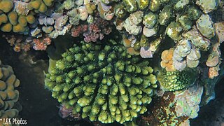
The Great Barrier Reef Marine Park protects a large part of Australia's Great Barrier Reef from damaging activities. It is a vast multiple-use Marine Park which supports a wide range of uses, including commercial marine tourism, fishing, ports and shipping, recreation, scientific research and Indigenous traditional use. Fishing and the removal of artefacts or wildlife is strictly regulated, and commercial shipping traffic must stick to certain specific defined shipping routes that avoid the most sensitive areas of the park. The Great Barrier Reef is the largest and best known coral reef ecosystem in the world. Its reefs, almost 3000 in total, represent about 10 per cent of all the coral reef areas in the world. It supports an amazing variety of biodiversity, providing a home to thousands of coral and other invertebrate species, bony fish, sharks, rays, marine mammals, marine turtles, sea snakes, as well as algae and other marine plants.
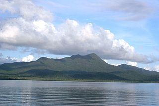
Hinchinbrook Island National Park is Australia's largest island national park. It is situated along the Cassowary Coast Queensland, Australia. The nearest capital city is Brisbane approximately 1,240 km to the south. Lucinda is 135 km or 1.5 hours drive north of Townsville being the closest North Queensland provincial city. Cairns a Far North Queensland provincial city is two and a half to 3 hours drive north from Cardwell. The main geographical features in the park are the rugged Hinchinbrook Island, including Mount Bowen, The Thumb, Mount Diamantina and Mount Straloch.
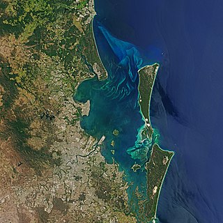
Moreton Bay is a bay located on the eastern coast of Australia 14 kilometres (8.7 mi) from central Brisbane, Queensland. It is one of Queensland's most important coastal resources. The waters of Moreton Bay are a popular destination for recreational anglers and are used by commercial operators who provide seafood to market.
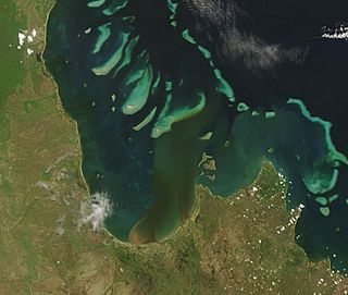
Princess Charlotte Bay is a large bay on the east coast of Far North Queensland at the base of Cape York Peninsula, 350 km north northwest of Cairns. Princess Charlotte Bay is a part of the Great Barrier Reef Marine Park and it is a habitat for the dugong.

The Great Sandy Strait is a strait in the Australian state of Queensland of 70 kilometres (43 mi) length which separates mainland Queensland from Fraser Island. It is also a locality in the Fraser Coast Region local government area. In the 2021 census, Great Sandy Strait had a population too low to be reported.
Shoalwater Bay Military Training Area is a heritage-listed military installation at Byfield Road, Byfield, Shire of Livingstone, Queensland, Australia. It is a large, relatively undisturbed and intact natural system with a wide variety of coastal landforms and a high level of biodiversity. It contains a diverse range of marine and coastal wetland landscapes, vegetation types and ecosystems. It was added to the Australian Commonwealth Heritage List on 22 June 2004.

The Port Phillip Heads Marine National Park is a marine protected area located in the vicinity of the bay of Port Phillip, between the Bellarine and Mornington Peninsulas, in Victoria, Australia. The 3,580-hectare (8,800-acre) marine national park comprises six separate sites located approximately 60 kilometres (37 mi) south-west of Melbourne and stretches along 40 kilometres (25 mi) of coastline of Victoria.

Hikkaduwa National Park is one of the three marine national parks in Sri Lanka. The national park contains a fringing coral reef of high degree of biodiversity. The area was declared a wildlife sanctuary on May 18, 1979, and then on August 14, 1988, upgraded to a nature reserve with extended land area. The growth of the number of visitors in the next 25 years increased the degradation of the coral reef. To reduce the effects to the ecosystem, the reef was declared a national park on September 19, 2002.

The Coral Sea Reserves Ramsar Site comprises the 17,289 km2 of oceanic island and reef habitats within the former Coringa-Herald National Nature Reserve and the former Lihou Reef National Nature Reserve in the Australian Coral Sea Islands Territory.

Halodule uninervis is a species of seagrass in the family Cymodoceaceae. It is native to the western Pacific and Indian Oceans. Common names include narrowleaf seagrass in English and a'shab bahriya in Arabic.
Cape Byron Marine Park is one of four marine parks in New South Wales, Australia, and is the most recently sanctioned. The Cape Byron Marine Park is located in Northern NSW and extends 37 kilometres (23 mi) from the Brunswick River to Lennox Head. The marine park extends out to 3 nautical miles which dictates the border between state and federal jurisdiction. The marine park covers an area of 220 square kilometres (85 sq mi) and includes a variety of marine terrain including beaches, rocky shores, open ocean and the tidal waters of the Brunswick River and its tributaries, the Belongil Creek and Tallow Creek. The Cape Byron Marine Park was declared in 2002 and the zoning plan was implemented in April 2006. Of the 15 distinct marine ecosystems identified within the Tweed-Moreton bioregion, the Cape Byron Marine Park supports 10 of these.
The Point Cook Coastal Park covers an area of 863 hectares and includes the Cheetham Wetlands. The park extends from the RAAF Williams Point Cook Base northeast along the coast to the Laverton creek which comprises its northern boundary. The park is approximately 20 kilometres (12 mi) from Melbourne, Australia in a southwesterly direction along Port Phillip Bay. The park is adjoined by the Point Cook Marine Sanctuary, which extends around the point to the south and the east. The northwestern boundary to the park is residential housing.
The St. Croix East End Marine Park (STXEEMP) was established to "protect territorially significant marine resources, and promote sustainability of marine ecosystems, including coral reefs, sea grass beds, wildlife habitats and other resources, and to conserve and preserve significant natural areas for the use and benefit of future generations." It is the U.S. Virgin Islands’ first territorially designated and managed marine protected area (MPA).

The Ashmore Reef Marine Park is an Australian marine park that covers the Ashmore Reef, which is located about 630 km (390 mi) north of Broome and 110 km (68 mi) south of the Indonesian island of Rote. The marine park covers an area of 583 km2 (225 sq mi) and is assigned IUCN category Ia. It is one of 13 parks managed under the North-west Marine Parks Network.

Marine Conservation Cambodia (MCC) is a non-profit, marine conservation organisation based in Koh Ach Seh, Kep archipelago.
Nosy Ve-Androka National Park is a Protected Marine Area located in the southwestern part of Madagascar, south of Tulear, and 40 km south of the tourist village of Anakao. It lies between latitudes 25 ° 29/25 ° 09 South and longitudes 44 ° 50/45 ° 06 East and covers an area of 92080 ha. It is composed of Core Areas totalling 28,820 ha and Buffer Zones totalling 63,260 ha. The park is made up of eight parcels in two clusters, with part found along the coast adjacent to Tsimanampetsotsa National Park. It includes sections of the rich coral reef system of South West Madagascar in the Mozambique Channel, recognized as the third largest reef system in the world. Diversity of habitats include fringing reefs, barrier reefs, coral reef beds, seagrass area, open sea, rocky coast and sandy beaches. The Nosy Ve-Androka National Park contains about 140 species of coral and 240 species of fish. There are also rare species such as Coelacanths, marine turtle species, dugongs, dolphins and whales and sandy beaches that are used by nesting sea turtles.
The East African coral coast is a marine ecoregion along the eastern coast of Africa. It extends along the coasts of Kenya, Tanzania, and northern Mozambique, from Lamu in Kenya to Angoche in Mozambique. It adjoins the Northern Monsoon Current Coast ecoregion to the north, and the Bight of Sofala/Swamp Coast ecoregion to the south.

The Mayotte Marine Natural Park is a marine park surrounding Mayotte, a French overseas region. Mayotte is part of the Comoro Islands archipelago, which lies within the Mozambique Channel in the western Indian Ocean. Established in 2010, the park covers the entirety of Mayotte's territorial waters and exclusive economic zone. It is contiguous with the Glorioso Islands Marine Natural Park, which was established two years later.


