Carnarvon Highway

Last updated

Carnarvon Highway

New South Wales
Carnarvon Highway, St George - Surat (1979) - 50586147146.jpg
Carnarvon Highway between St George and Surat, 1979
Location Carnarvon Hwy.svg
General information
TypeHighway
Length697 km (433 mi) [1]
Gazetted November 1933 (NSW, as Main Road 232) [2]
August 1998 (NSW, as State Highway 28) [3]
Route number(s)
  • AUS Alphanumeric Route A7.svg A7 (2004–present)
    (Rolleston–Roma)
  • AUS Alphanumeric Route A55.svg A55 (2004–present)
    (Roma–St George)
  • Australian national route 46.svg National Route 46 (1997–present)
    (St George–QLD/NSW border)
Former
route number
  • Australian national route 55.svg National Route 55 (1983–2004)
    (Rolleston–St George)
  • Australian national route 55.svg National Route 55 (1983–1997)
    (St George–QLD/NSW border)
Major junctions
North endAUS Alphanumeric Route A7.svgAustralian state route 60.svg Dawson Highway
Rolleston, Queensland
 
South endAUS Alphanumeric Route B76.svg Gwydir Highway
Moree, New South Wales
Location(s)
Major settlements Injune, Roma, Surat, St George, Mungindi
Highway system

Carnarvon Highway is a state highway in Queensland and New South Wales, Australia, linking the township of Rolleston in Queensland's Central Highlands Region, via the town of St George, eventually to Moree in northern New South Wales. It is the main access road to the Carnarvon National Park, and serves as a strategic route to take B-doubles and other large vehicles (which cannot use Bruce Highway) to the Queensland ports north of Rockhampton.

Contents

Route

Carnarvon Highway commences at the intersection with Dawson Highway just west of Rolleston in Queensland, and heads in southerly direction until it reaches Roma, where it shares a short concurrency with Warrego Highway, and continues south to St George, where it meets the Moonie, Balonne, and Castlereagh Highways. It crosses the state border at Mungindi to eventually terminate at the intersection with Gwydir Highway in Moree, in New South Wales.

History

The passing of the Main Roads (Amendment) Act of 1929 [4] (which amended the original Main Roads Act of 1924 [5] ) through the Parliament of New South Wales on 8 April 1929 provided for the declaration of State Highways, Trunk Roads and Main Roads, partially funded by the State government through the Main Roads Board (later the Department of Main Roads, and eventually Transport for NSW). Main Road 232 was declared on 21 November 1933, from the intersection with Main Road 338 (Moree-Boggabilla Road, later to become Newell Highway) at Moree, via Ashley, Garah and Boomi to the state border with Queensland at Boonangar, [2] and Main Road 367 was declared on 23 March 1937 from the intersection with Main Road 232 at Garah to the state border with Queensland at Mungindi. [6]

The passing of the Roads Act of 1993 [7] through the Parliament of New South Wales updated road classifications and the way they could be declared within New South Wales. Under this act, Carnarvon Highway was declared as State Highway 28 on 7 August 1998, from the intersection with Newell Highway at Moree via Ashley and Garah to the state border with Queensland at Mungindi, subsuming Main Road 367; [3] the southern end of Main Road 232 was truncated to meet Carnarvon Highway at Garah. [3] The highway today, as Highway 28, still retains this declaration. [8]

It was formerly known as Carnarvon Developmental Road north of Roma. [9]

Queensland signed its portion of Carnarvon Highway as National Route 55 between 1983 and 1997. However, New South Wales had previously signed Castlereagh Highway between Gilgandra and Walgett as National Route 55 in 1974, extending it to the border by 1983. This caused a major discrepancy for many years in that National Route 55 met the border at Mungindi but abruptly begun again over 100 kilometres (62 mi) west along the border at Hebel. The Queensland Road Department eventually changed this in 1997, diverting National Route 55 along its portion of Castlereagh Highway over the border south to Hebel; the former allocation between St George and Mungindi was then re-allocated National Route 46, however the New South Wales portion remained unallocated. With Queensland's conversion to the newer alphanumeric system in 2004, its route number was updated to route A7 between Rolleston and Roma (continuing north along Dawson and Gregory Highways to Emerald and Charters Towers), and A55 between Roma and St George; it is still allocated National Route 46 between St George and the border, and is still unallocated between the border and Moree.

Roads of Strategic Importance upgrades

The Roads of Strategic Importance initiative, last updated in March 2022, includes the following projects for Carnarvon Highway.

Corridor upgrade

A lead project to upgrade the Townsville to Roma corridor, including sections of Gregory, Dawson and Carnarvon Highways and surrounding state and council roads, at an estimated cost of $125 million, commenced construction of some work projects in 2020. Planning continues for other projects. [10]

Intersection upgrade Arcadia Valley Road

A project to upgrade the intersection with Arcadia Valley Road at a cost of $925,000 was completed in January 2022. [11] This project was targeted for "early works" by the Queensland Government. [12]

Intersection upgrade Castlereagh Highway

A project to upgrade the intersection with Castlereagh Highway at a cost of $3.4 million is due for completion in mid-2022. [13] This project is targeted for "early works" by the Queensland Government. [12]

Intersection upgrade Salmon Road

A project to upgrade the intersection with Salmon Road at a cost of $4.8 million is due for completion in mid-2022. [14] This project is targeted for "early works" by the Queensland Government. [12]

Orange Hill safety treatments

A project to upgrade Carnarvon Highway near Orange Hill at a cost of $3.9 million was expected to finish in late 2021. [15] This project was targeted for "early works" by the Queensland Government. [12]

Other upgrades

Widen and seal

A project to widen and seal a section of road north of Injune, at a cost of $5.22 million, started in May 2021. [16]

A project to widen and seal a section of road east of St George, at a cost of $4.5 million, was completed in August 2021. [17]

Replace steel culvert

A project to replace a steel culvert just east of Surat, at a cost of $3.6 million, was completed in October 2021. [18]

Widen and replace culvert

A project to widen and replace a culvert north of Roma, at a cost of $1.36 million, started in September 2021. [19]

Proposals

The Queensland Inland Freight Route is a proposal to upgrade the existing highways from Charters Towers to Mungindi. This would involve significant upgrades to Carnarvon Highway between Rolleston and Mungindi.

List of towns on the Carnarvon Highway

Major intersections

StateLGALocation [1] km [1] miDestinationsNotes
Queensland Central Highlands Rolleston 00.0AUS Alphanumeric Route A7.svgAustralian state route 60.svg Dawson Highway (A7 west, State Route 60 east)  Springsure, Moura, Blackwater Northern terminus of highway, route A7 continues west along Dawson Highway
Maranoa Roma 263163AUS Alphanumeric Route A2.svg Warrego Highway (A2 west)  Mitchell Concurrency with route A2
Southern terminus of route A7, northern terminus of route A55
269167AUS Alphanumeric Route A2.svg Warrego Highway (A2 east)  Miles, Brisbane
Surat 343213Australian state route 87.svg Surat Developmental Road (State Route 87)  Meandarra
Balonne St George 449279Australian state route 49.svg Moonie Highway (State Route 49 east)  Dalby Concurrency with State Route 49
459285Australian state route 49.svg Balonne Highway (State Route 49 west)  Mitchell, Cunnamulla
466290AUS Alphanumeric Route A55.svg Castlereagh Highway (A55)  Dirranbandi, Hebel Route A55 continues south along Castlereagh Highway
Northern terminus of National Route 46
Nindigully 503313Australian state route 85.svg Barwon Highway (State Route 85)  Goondiwindi
Mungindi 577359Australian national route 46.svg Carnarvon HighwaySouthern terminus of National Route 46
State border along Barwon River Queensland – New South Wales state border
New South Wales Moree Plains Mungindi Carnarvon Highway
Moree 697433AUS Alphanumeric Route B76.svg Gwydir Highway (B76)  Goondiwindi, Narrabri, Collarenebri Southern terminus of highway
1.000 mi = 1.609 km; 1.000 km = 0.621 mi

See also

Related Research Articles

<span class="mw-page-title-main">Newell Highway</span> Highway in New South Wales, Australia

Newell Highway is a national highway in New South Wales (NSW), Australia. It provides the major road link between southeastern Queensland and Victoria via central NSW and as such carries large amounts of freight. At 1,058 kilometres (657 mi) in length, the Newell is the longest highway in NSW, and passes through fifteen local government areas.

<span class="mw-page-title-main">Gwydir Highway</span>

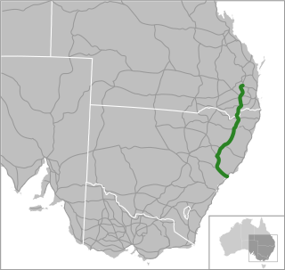
Gwydir Highway is a 568-kilometre (353 mi) state highway in northern New South Wales, Australia. The highway was named after the Gwydir River, which in turn was named after a locale in Wales.

<span class="mw-page-title-main">New England Highway</span> Highway in New South Wales and Queensland

New England Highway is an 883-kilometre (549 mi) long highway in Australia running from Yarraman, north of Toowoomba, Queensland at its northern end to Hexham at Newcastle, New South Wales at its southern end. It is part of Australia's National Highway system, and forms part of the inland route between Brisbane and Sydney.

<span class="mw-page-title-main">Cobb Highway</span>

Cobb Highway is a state highway in the western Riverina and the far western regions of New South Wales, with a short section in Victoria, Australia, designated part of route B75.

<span class="mw-page-title-main">Capricorn Highway</span> Highway in Queensland, Australia

The Capricorn Highway is located in Central Queensland, Australia, and links the city of Rockhampton with western Queensland. The highway is 575 kilometres (357 mi) long, and joins the Landsborough Highway at Barcaldine. Formerly National Route 66, Queensland began to convert to the alphanumeric system much of Australia had adopted in the early-2000s and is now designated as A4. The highway runs parallel with the Tropic of Capricorn, hence its name.

<span class="mw-page-title-main">Castlereagh Highway</span> Highway in New South Wales and Queensland, Australia

Castlereagh Highway is a 790-kilometre (490 mi) state highway located in New South Wales and Queensland, Australia. From north to south the highway traverses South West Queensland and the North West Slopes, Orana, and Central West regions of New South Wales.

<span class="mw-page-title-main">Kamilaroi Highway</span> Highway in New South Wales

Kamilaroi Highway is a 605-kilometre (376 mi) state highway located in the north-western region of New South Wales, Australia, and links Bourke via Walgett and Narrabri to Willow Tree. The highway is named after the Kamilaroi Indigenous Australian people who live in the area.

<span class="mw-page-title-main">Mount Lindesay Highway</span> Highway in Queensland

Mount Lindesay Highway is an Australian national highway located in Queensland. The highway runs southwest from Brisbane, where it leaves Ipswich Road in the suburb of Moorooka, to the Queensland – New South Wales border and is 116 kilometres (72 mi) in length. For most of its length it is roughly aligned with the Sydney–Brisbane rail corridor. At its southern end these transport routes take different passes over the Scenic Rim into the Northern Rivers region. It is designated National Route 13.

<span class="mw-page-title-main">Mungindi</span> Town in New South Wales, Australia

Mungindi is a town and locality on the border of New South Wales (NSW) and Queensland, Australia. The town is within Moree Plains Shire in New South Wales. Within Queensland, the locality is split between the Shire of Balonne and the Goondiwindi Region with the town in the Shire of Balonne. It possesses a New South Wales postcode. Mungindi sits on the Carnarvon Highway and straddles the Barwon River which is the border between New South Wales and Queensland. At the 2016 census, Mungindi had a population of 601 on the New South Wales side, while the population on the Queensland side was 146.

<span class="mw-page-title-main">Dawson Highway</span>

The Dawson Highway is a state highway in Queensland, Australia. It runs for 405 kilometres (252 mi) between Gladstone and Springsure where it terminates. From Gladstone to Rolleston it is signed as State Route 60, and then A7 onwards to Springsure. It continues west for another 247 kilometres (153 mi) as Dawson Developmental Road to Tambo on the Landsborough Highway. North of Springsure, A7 becomes the Gregory Highway.

<span class="mw-page-title-main">Gregory Highway</span> State highway in Queensland, Australia

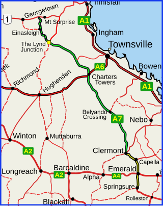
The Gregory Highway is a state highway in Queensland, Australia that serves the major coal-mining centres of Central Queensland. The highway was named after Augustus Gregory, an early explorer.

<span class="mw-page-title-main">Pacific Motorway (Brisbane–Brunswick Heads)</span> Motorway in New South Wales and Queensland

The Pacific Motorway is a motorway in Australia between Brisbane, Queensland, and Brunswick Heads, New South Wales, through the New South Wales–Queensland border at Tweed Heads.

<span class="mw-page-title-main">Garah, New South Wales</span> Town in New South Wales, Australia

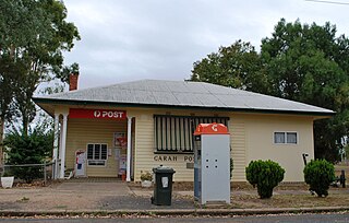
Garah is a town in north western New South Wales, Australia. The town is in the Moree Plains Shire local government area. At the 2016 census, Garah and the surrounding area had a population of 306.

<span class="mw-page-title-main">Gulf Developmental Road</span> Highway in Queensland, Australia

Gulf Developmental Road is an Australian highway linking the Cairns and Normanton regions in northern Queensland, Australia. It is the only sealed (asphalt) road linking these two regions.

<span class="mw-page-title-main">Gold Coast Highway</span> Road in Queensland, Australia

Gold Coast Highway links the coastal suburbs of the Gold Coast in south eastern Queensland such as Miami, Mermaid Beach, Tugun, Bilinga and across the border of New South Wales to the Tweed Heads suburb of Tweed Heads West. At 39.6 kilometres (24.6 mi) in length, the highway runs just west of Pacific Motorway at Pacific Pines to Pacific Motorway at Tweed Heads West. It passes through the numerous popular tourist areas including Surfers Paradise and Broadbeach, a commercial centre at Southport, residential areas, shopping centres and the Gold Coast (Coolangatta) Airport.

<span class="mw-page-title-main">Mungindi Bridge</span> Bridge in Mungindi, New South Wales

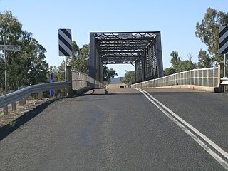
The Mungindi Bridge is a road bridge that carries the Carnarvon Highway across the Barwon River on the Queensland/New South Wales border at Mungindi, New South Wales, Australia.

<span class="mw-page-title-main">South West Queensland</span> Region in Queensland, Australia

South West Queensland is a remote region in the Australian state of Queensland which covers 319,808 km2 (123,479 sq mi). The region lies to the south of Central West Queensland and west of the Darling Downs and includes the Maranoa district and parts of the Channel Country. The area is noted for its cattle grazing, cotton farming, opal mining and oil and gas deposits.

The Great Inland Way is an Australian road route from Sydney, New South Wales to Cairns in Queensland. It has been designated by the Queensland Government as a State Strategic Touring Route.

Queensland Inland Freight Route is a proposal to upgrade the existing highways from Charters Towers to Mungindi in Queensland, Australia. It would be a quality two-lane alternative freight route to the Bruce Highway.

Roads of Strategic Importance in Queensland is a list of roads in Queensland, Australia, that are the subject of one or more road improvement projects under the Roads of Strategic Importance (ROSI) initiative of the Australian Government. The purposes of this document are to:

References

  1. 1 2 3 Google (17 October 2022). "Carnarvon Highway" (Map). Google Maps . Google. Retrieved 17 October 2022.
  2. 1 2 "Main Roads Act, 1924-1931". Government Gazette of the State of New South Wales. No. 200. National Library of Australia. 1 December 1933. p. 4195. Archived from the original on 17 October 2022. Retrieved 17 October 2022.
  3. 1 2 3 "Roads Act". Government Gazette of the State of New South Wales. No. 117. National Library of Australia. 7 August 1998. p. 6001. Archived from the original on 17 October 2022. Retrieved 17 October 2022.
  4. State of New South Wales, An Act to amend the Main Roads Act, 1924-1927; to confer certain further powers upon the Main Roads Board; to amend the Local Government Act, 1919, and certain other Acts; to validate certain payments and other matters; and for purposes connected therewith. Archived 12 August 2022 at the Wayback Machine 8 April 1929
  5. State of New South Wales, An Act to provide for the better construction, maintenance, and financing of main roads; to provide for developmental roads; to constitute a Main Roads Board Archived 11 August 2022 at the Wayback Machine 10 November 1924
  6. "Main Roads Act, 1924-1936". Government Gazette of the State of New South Wales. No. 43. National Library of Australia. 2 April 1937. p. 1412. Archived from the original on 17 October 2022. Retrieved 17 October 2022.
  7. State of New South Wales, An Act to make provision with respect to the roads of New South Wales; to repeal the State Roads Act 1986, the Crown and Other Roads Act 1990 and certain other enactments; and for other purposes. Archived 11 August 2022 at the Wayback Machine 10 November 1924
  8. Transport for NSW (August 2022). "Schedule of Classified Roads and Unclassified Regional Roads" (PDF). Government of New South Wales. Retrieved 1 August 2022.
  9. Queensland Government - Department of Transport and Main Roads - Maps
  10. "Townsville to Roma Corridor Upgrade". Department of Infrastructure, Transport, Regional Development and Communications. 29 March 2022. Retrieved 6 May 2022.
  11. "Carnarvon Highway and Arcadia Valley Road Intersection Upgrade". Department of Infrastructure, Transport, Regional Development and Communications. 12 April 2022. Retrieved 6 May 2022.
  12. 1 2 3 4 "ROSI early works package" (PDF). Queensland Government. 29 April 2020. Retrieved 7 May 2022.
  13. "Carnarvon Highway and Castlereagh Highway Intersection Upgrade". Department of Infrastructure, Transport, Regional Development and Communications. 28 January 2022. Retrieved 6 May 2022.
  14. "Carnarvon Highway and Salmon Road Intersection Upgrade". Department of Infrastructure, Transport, Regional Development and Communications. 12 January 2022. Retrieved 6 May 2022.
  15. "Carnarvon Highway - Orange Hill Safety Treatments". Department of Infrastructure, Transport, Regional Development and Communications. 22 April 2021. Retrieved 6 May 2022.
  16. "Carnarvon Highway (Injune-Rolleston), widen and seal". Queensland Government. 24 November 2021. Retrieved 1 June 2022.
  17. "Carnarvon Highway (Mungindi-St George), widen and seal". Queensland Government. 22 November 2021. Retrieved 1 June 2022.
  18. "Carnarvon Highway (Surat-Roma), replace steel culvert". Queensland Government. 30 November 2021. Retrieved 2 June 2022.
  19. "Carnarvon Highway (Roma-Injune), widen and replace culvert". Queensland Government. 25 November 2021. Retrieved 2 June 2022.