Taemas Bridge

Last updated

Taemas Bridge
Taemas Bridge, NSW, from north.jpg
Coordinates 35°00′12″S148°50′53″E / 35.0033516°S 148.8481164°E / -35.0033516; 148.8481164 Coordinates: 35°00′12″S148°50′53″E / 35.0033516°S 148.8481164°E / -35.0033516; 148.8481164
CarriesWee Jasper Road
Crosses Murrumbidgee River
Localenear Wee Jasper, Yass Valley Council, New South Wales, Australia
BeginsTaemas
Ends Cavan, New South Wales
Official nameTaemas Bridge over Murrumbidgee River
Other name(s)RTA Bridge No. 6629
Owner Transport for NSW
Characteristics
Design Truss
MaterialSteel
Trough construction Reinforced concrete
Pier constructionConcrete
Total length200 metres (660 ft)
Width5.5 metres (18 ft)
Longest span45.7 metres (150 ft)
No. of spans4 main, 2 approaches
No. of lanes Two
History
Constructed by
Fabrication by Dorman Long & Co
Construction cost 60,895
Opened1931
Closed
  • Taemas Bridge (1888-1925) (MacDonald truss)
  • Temporary punt (1925-1929)
  • Low-level bridge (1929)
  • Temporary punt (1929-1931)
Official nameTaemas Bridge over Murrumbidgee River; RTA Bridge No. 6629
TypeState agency heritage (built)
Criteria a., c., d., g.
Designated18 August 2005
Reference no.Heritage Act, 1977 (NSW) s 170
TypeRoad Bridge
CategoryTransport - Land
Builders
Location
Taemas Bridge
References
[1]

The Taemas Bridge is a two-lane road bridge that carries the Wee Jasper Road across the Murrumbidgee River, at the settlement of Taemas, near Wee Jasper in the Yass Valley Council local government area of New South Wales, Australia. The bridge crosses on the river just before it enters Lake Burrinjuck, which has been created by the Burrinjuck Dam. The bridge is a key part of the road between Yass and Wee Jasper, and from there, to Tumut. The bridge is located approximately 26 kilometres (16 mi) from Yass and 22 kilometres (14 mi) from Wee Jasper. The property is owned by Transport for NSW. Under the Heritage Act, 1977 (NSW) s 170, the bridge was added to the New South Wales State agency heritage register on 18 August 2005. [1]

Contents

History

A metal MacDonald truss bridge, also known as the Taemas Bridge, was built c.1888, located 3 kilometres (2 mi) downriver from the existing Taemas Bridge. [2] [3] In c.1924 this bridge was raised 5 metres (15 ft) and extended to 270 metres (885 ft) with the addition of numerous timber approach spans by the Water Conservation and Irrigation Commission in association with the construction of Burrinjuck Dam. This bridge was destroyed by a flood in May 1925. The local member of the NSW Parliament, Jack Tully, promised to have the destroyed Taemas Bridge replaced as soon as possible. [1]

In the interim, the NSW Public Works Department (PWD) established a punt service adjacent to the destroyed bridge until such time as a new bridge could be constructed. [4] The punt remained in operation for almost four years later, until it was swept away in April 1929. [5] A low-level bridge was constructed in 1929, but the water rose and destroyed it that same year. In July 1929, another punt was then established to provide alternative access, and was worked hard carrying wool and other produce. [1]

Description

The site of the current Taemas Bridge was selected by the Public Works Department and is located approximately 3 kilometres (2 mi) upriver from the former bridge site. This led to a longer road route, yet enabled a shorter bridge to be constructed in a location were flood levels were expected to be lower. The current bridge was completed in 1931 and is over 200 metres (660 ft) long. [1]

The centre of the bridge Wee Jasper Road, Bridge over Murrumbidgee river 01.jpg
The centre of the bridge

After several years of inaction, the Goodradigbee and Yass councils organised a protest meeting, and the NSW Government asked Tulloch's Phoenix Ironworks in Sydney to order steel for the bridge. Steel members show rolling marks of Dorman Long & Co, so were presumably imported from Middlesbrough, England. Monier Pipe and Reinforced Concrete Works constructed piers and installed the bridge. Once constructed, Gilroy and Robson Ltd gravelled the bridge approaches ready for opening. [1]

This two-lane steel through truss bridge spans the Murrumbidgee River in the upper reaches of the Burrinjuck Dam storage. Its height has been set to clear the large floods to which the valley is subjected (and which destroyed its predecessor). [1]

The bridge has four main spans and two approach spans. Approach spans are supported by six 13.7-metre (45 ft) longitudinal steel beams (or stringers) which in turn support a reinforced concrete deck. There are cross girders at midspan to stabilise the beams. The main spans are 45.7 metres (150 ft), having eight bays in a Pratt truss configuration. Connections are by riveting, and the trusses make extensive use of lattice bracing to produce compound members. Tension members are stabilised by riveted Vierendeel plates. [1]

The comparatively narrow 5.5-metre (18 ft) deck of the bridge is unsurfaced concrete, edged by kerbs with pipe handrails with infill wire netting. [1]

The substantial piers have two cylindrical legs founded on rock with up to three lateral tie beams. The lower sections bell out to larger diameter below the bottom cross beam. Above the upper cross beam the columns are capped with octagonal capitals which support the bridge bearings which are of rocker type. [1]

Monumental style is used in the abutments which are of U shape, but with bold corners capped with imposing endposts. The side faces of the abutment and endposts are inclined. [1]

The bridge was opened in 1931 and cost 60,895. Even after the new bridge was opened some locals still forded the river near the former bridge if they could, to save petrol from the extra distance required by road to reach the new bridge. [1] There is a carpark at the southern end of the bridge, from which the Murrumbidgee River can be accessed.

Heritage listing

The southern end of the bridge Taemas Bridge.jpg
The southern end of the bridge

The Taemas Bridge has historical, social, technical, aesthetic and representative significance within the Yass-Tumut-Yarrowlumla-Gundagai area. It has provided a crossing of a major waterway, the Murrumbidgee River, for over seventy years and its long term reliability has facilitated the agricultural activities and economies of the surrounding areas. The history of transport in the region has been shaped by the Murrumbidgee and the difficulty of providing crossings of this large and flood prone waterway. The bridge represents a significant technical achievement, its robust design and its positioning, with the site of the former crossing downstream and documentary sources, demonstrate the intelligence, effort and investment required to construct a lasting and reliable crossing of this major and dynamic waterway. The bridge is of aesthetic significance, being an impressive structure of considerable length crossing a major waterway and having landmark qualities on the Yass-Tumut road. The monumental style of the abutments reflects the importance ascribed to the crossing by the Public Works Department and the community. The bridge has local social significance. The loss of the previous bridge in record flood was a major blow to the local community using this important transport and communication route. The community was involved in the debate surrounding the siting of the existing bridge, and continued to express dismay at the lengthy delay in its construction. The bridge is a landmark to which local travellers are likely to attach a sense of place and self. The bridge is a good, intact example of large scale truss design in the early to mid twentieth century. [1]

Taemas Bridge over Murrumbidgee River was listed on the New South Wales State agency heritage register on 18 August 2005 having satisfied the following criteria. [1]

The place is important in demonstrating the course, or pattern, of cultural or natural history in New South Wales.

Taemas Bridge is historically significant as an important transport link in the State's south west. It has provided a reliable crossing of a major waterway, the Murrumbidgee River, between the districts of Yass and Tumut for over seventy years. The history of transport in the region has been shaped by the Murrumbidgee and the difficulty of providing crossings of this large and flood prone waterway. The story of the Taemas Bridge, a long-awaited replacement of an equally ambitious bridge washed away in flood, is articulate about the interaction between the communities of the Yass-Tumut area and their environment and also about the efforts and strategies of the government in providing reliable access on important rural transport routes in NSW. The long term reliability of the Taemas bridge has facilitated the agricultural activities and economies of the surrounding areas. [1]

The place is important in demonstrating aesthetic characteristics and/or a high degree of creative or technical achievement in New South Wales.

The Taemas Bridge represents a significant technical achievement. The design of this robust metal bridge and its positioning, with the site of the former crossing downstream and documentary sources, demonstrate the intelligence, effort and investment required to construct a lasting and reliable crossing of this major and dynamic waterway. The bridge is of aesthetic significance, being an impressive structure of considerable length crossing a major waterway and having landmark qualities on the Yass-Tumut road. The monumental style of the abutments reflects the importance ascribed to the crossing by the Public Works Department and the community. [1]

The place has a strong or special association with a particular community or cultural group in New South Wales for social, cultural or spiritual reasons.

The bridge has local social significance. The loss of the previous bridge in record flood was a major blow to the local community using this important transport and communication route. The community was involved in the debate surrounding the siting of the existing bridge, and continued to express dismay at the lengthy delay in its construction. The monumental style of the abutments would seem to reflect the importance ascribed to the crossing by the Public Works Department and the community. The bridge is a landmark to which local travellers are likely to attach a sense of place and self. [1]

The place possesses uncommon, rare or endangered aspects of the cultural or natural history of New South Wales.

The bridge is a good, intact example of large scale truss design in the heyday of the rivet. [1]

See also

Related Research Articles

Murrumbidgee River Major river in southeastern Australia

The Murrumbidgee River is a major tributary of the Murray River within the Murray–Darling basin and the second longest river in Australia. It flows through the Australian state of New South Wales and the Australian Capital Territory, descending 1,500 metres (4,900 ft) over 1,485 kilometres (923 mi), generally in a west-northwesterly direction from the foot of Peppercorn Hill in the Fiery Range of the Snowy Mountains towards its confluence with the Murray River near Boundary Bend.

Gundagai Town in New South Wales, Australia

Gundagai is a town in New South Wales, Australia. Although a small town, Gundagai is a popular topic for writers and has become a representative icon of a typical Australian country town. Located along the Murrumbidgee River and Muniong, Honeysuckle, Kimo, Mooney Mooney, Murrumbidgee and Tumut mountain ranges, Gundagai is 390 kilometres (240 mi) south-west of Sydney. Until 2016, Gundagai was the administrative centre of Gundagai Shire local government area. In the 2016 census the population of Gundagai was 1,925.

Burrinjuck Dam Dam in South West Slopes, New South Wales

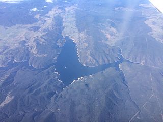
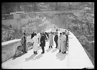
Burrinjuck Dam is a heritage-listed major gated concrete-walled gravity hydro-electric dam at Burrinjuck, Yass Valley Shire, New South Wales, Australia. It has three spillways across the Murrumbidgee River located in the South West Slopes region of New South Wales, Australia. The dam's purpose includes flood mitigation, hydro-power, irrigation, water supply and conservation. The impounded reservoir is called Lake Burrinjuck. It was designed by Lawrence Augustus Burton Wade and built from 1907 to 1927 by Lane & Peters, Sydney. It is also known as Barren Jack Dam and Barrenjack. The property was owned by Department of Planning and Infrastructure. It was added to the New South Wales State Heritage Register on 2 April 1999.

William Francis Sheahan also known as Bill Sheahan or Billy Sheahan, was an Australian politician, elected as a member of the New South Wales Legislative Assembly.

Wee Jasper, New South Wales Town in New South Wales, Australia

Wee Jasper is a hamlet in the Goodradigbee valley at the western foot of the Brindabella Ranges, near Burrinjuck Dam in New South Wales, Australia in Yass Valley Shire. It is located about 90 km north-west of Canberra and 60 km south-west of Yass. At the 2016 census, Wee Jasper and the surrounding area had a population of 100.

Burrinjuck, New South Wales Town in New South Wales, Australia

Burrinjuck is a village community in the far eastern part of the Riverina. It is situated by road, about 15 kilometres southwest from Woolgarlo and 28 kilometres south from Bookham. The name of the town is derived from an Aboriginal word meaning 'mountain with a rugged top'. At the 2016 census, the Burrinjuck area had a population of 19.

Goodradigbee River River in Australia

Goodradigbee River, a perennial stream that is part of the Murrumbidgee catchment within the Murray–Darling basin, is located in the Snowy Mountains district of New South Wales, Australia.

<span class="mw-page-title-main">Prince Alfred Bridge</span> 1860s wrought iron truss bridge in Gundagai

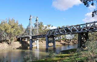
The Prince Alfred Bridge is a wrought iron truss and timber beam partially-disused road bridge over the Murrumbidgee River and its floodplain at Middleton Drive, Gundagai, Cootamundra-Gundagai Regional Council, New South Wales, Australia. The heritage-listed road bridge was designed by William Christopher Bennett and built from 1864 to 1867 by Francis Bell. It is also known as Prince Alfred Bridge - Iron Road Bridge and Iron Bridge over Murrumbidgee River at Gundagai. The iron bridge is owned by Transport for NSW and the timber viaduct is owned by Crown Lands. The bridge was added to the New South Wales State Heritage Register on 5 July 2019 and on the Register of the National Estate on 21 March 1978.

<span class="mw-page-title-main">Bethanga Bridge</span> Bridge in New South Wales, Australia

The Bethanga Bridge is a steel truss road bridge that carries the Riverina Highway across Lake Hume, an artificial lake on the Murray River in Australia. The dual heritage-listed bridge crosses the border between the Australian states of New South Wales and Victoria, linking the Victorian towns of Bellbridge and Bethanga with the regional New South Wales city of Albury.

<span class="mw-page-title-main">Morpeth Bridge</span> Bridge in New South Wales, Australia

Morpeth Bridge is a heritage-listed road bridge over the Hunter River at Morpeth, New South Wales, Australia. It was designed by Percy Allan and built from 1896 to 1898 by Samuel McGill. It is also known as Morpeth Bridge over the Hunter River. The property is owned by Transport for NSW.

<span class="mw-page-title-main">Yass River railway bridge, Yass</span> Bridge in New South Wales, Australia

The Yass River railway bridge is a heritage-listed disused railway bridge that carried the Yass Town Tramway across the Yass River at Yass, Yass Valley Shire, New South Wales, Australia. It was designed by engineer C. Fischer and NSW Government Tramways and built in 1892 by O. McMasters, North Sydney (fabrication) and McGill & Son (erection). It is also known as the Yass Town rail bridge over Yass River and the Yass Town Truss. The bridge is owned by RailCorp. It was added to the New South Wales State Heritage Register on 2 April 1999.

<span class="mw-page-title-main">Goodradigbee River Bridge</span> Bridge in New South Wales, Australia

The Goodradigbee River Bridge is a heritage-listed road bridge that carries Main Road across the Goodradigbee River in Wee Jasper, New South Wales, Australia. It was designed by Percy Allan and built in 1896 by W. J. Lansdown. The bridge is also known as the Wee Jasper Bridge over Goodradigbee River. The bridge is owned by Transport for NSW. It was added to the New South Wales State Heritage Register on 20 June 2000.

<span class="mw-page-title-main">Murray River railway bridge, Albury–Wodonga</span> Bridge in New South Wales, Australia

The Murray River railway bridge is a heritage-listed Australian railway bridge over the Murray River on the Main Southern line south of Albury in the City of Albury, New South Wales, and on the North Eastern line north of Wodonga in Victoria. The bridge was designed by John Whitton and built from 1883 to 1884 by J. S. Bennett, with iron work supplied by Westwood, Baillie, England. It is also known as the Rail Bridge over Murray River, Albury-Wodonga and the Albury Lattice Railway Bridge and Murray River Underbridge. The bridge is owned by RailCorp, and maintained by the Australian Rail Track Corporation as part of its lease of the line. It was added to the New South Wales State Heritage Register on 2 April 1999 and added to the Register of the National Estate on 18 April 1989.

Old Cobram-Barooga Bridge Historic site in New South Wales, Australia

Old Cobram-Barooga Bridge is a heritage-listed former road bridge and now footbridge over the Murray River at Barooga-Cobram Road, Barooga, New South Wales, Australia. The bridge links Barooga with Cobram, its sister town in Victoria. It was designed by Ernest de Burgh (engineer) and the New South Wales Department of Public Works and built from 1900 to 1902. It is also known as RMS Bridge No 3247. It is owned by Transport for NSW. It was added to the New South Wales State Heritage Register on 1 April 2016.

<span class="mw-page-title-main">Murrumbidgee River bridge, Carrathool</span> Bridge in New South Wales, Australia

The Murrumbidgee River bridge, Carrathool is a heritage-listed road bridge that, until its closure in 2019, carried Carrathool Road across the Murrumbidgee River in Carrathool, New South Wales, Australia. The bridge is owned by Transport for NSW. The bridge is also called the Carrathool Bridge over Murrumbidgee River and provides a key connection between the Sturt Highway and the Murrumbidgee Road. It was added to the New South Wales State Heritage Register on 20 June 2000.

The Junction Bridge is a heritage-listed road bridge that carries the Tumut Plains Road across the Tumut River, from Tumut to Tumut Plains in New South Wales, Australia. The bridge is owned by Transport for NSW. It was added to the New South Wales State Heritage Register on 20 June 2000.

<span class="mw-page-title-main">Murrumbidgee River railway bridge, Gundagai</span> Railway bridge in Australia

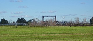
The Murrumbidgee River railway bridge is a heritage-listed railway bridge across the Murrumbidgee River located on the Tumut railway line at Gundagai in the Cootamundra-Gundagai Regional Council local government area of New South Wales, Australia. It was built in 1903. It is also known as the Gundagai Rail Bridge over Murrumbidgee River and the Murrumbidgee River Railway Bridge. The property was added to the New South Wales State Heritage Register on 2 April 1999.

<span class="mw-page-title-main">Paterson River bridge, Hinton</span> Bridge in New South Wales, Australia

The Hinton Bridge over Paterson River is a heritage-listed road bridge that carrier the Hinton-Morpeth Road across the Paterson River at Hinton, New South Wales, Australia. The bridge was designed by Ernest de Burgh and built in 1901. The bridge is owned by Transport for NSW. The bridge was added to the New South Wales State Heritage Register on 20 June 2000.

<span class="mw-page-title-main">McKanes Falls Bridge</span> Bridge in New South Wales, Australia

The McKanes Falls Bridge is a heritage-listed road bridge at McKanes Falls Road, South Bowenfels, New South Wales, Australia. It was designed by John McDonald and NSW Engineer for Bridges and built from 1892 to 1893 by NSW Public Works. It is also known as McKanes Bridge. The property is owned by Transport for NSW. It was added to the New South Wales State Heritage Register on 20 June 2000.

<span class="mw-page-title-main">Emu Plains Underbridge</span> Bridge in New South Wales, Australia

Emu Plains Underbridge is a heritage-listed steel truss railway underbridge located off Bruce Neale Dr approximately 1.3 kilometres (0.81 mi) west of the Penrith railway station in the western Sydney suburb of Penrith in the City of Penrith local government area of New South Wales, Australia. It was designed by James Fraser, the existing lines branch and the New South Wales Government Railways. It was built in 1907, with fabrication by R. Tulloch & Co.; and erection by day labour. It is also known as Emu Plains Underbridge and Penrith Underbridge. The property is owned by RailCorp, an agency of the Government of New South Wales. It was added to the New South Wales State Heritage Register on 28 June 2013.

References

  1. 1 2 3 4 5 6 7 8 9 10 11 12 13 14 15 16 17 18 "Taemas Bridge over Murrumbidgee River". New South Wales State Heritage Register . Office of Environment & Heritage . Retrieved 7 April 2020.
  2. "Taemas Bridge over Murrumbidgee River". RTA Heritage and Conservation Register. Archived from the original on 15 November 2010. Retrieved 13 January 2013.
  3. "Photo of old Taemas Bridge in 1915" . Retrieved 13 January 2013.
  4. "Taemas Bridge to be Rebuilt". The Canberra Times . 24 September 1926. p. 9 via Trove, National Library of Australia.
  5. "Graziers Requests". The Sydney Morning Herald . 27 July 1929. p. 12 via Trove, National Library of Australia.

Bibliography

Attribution

CC BY icon-80x15.png This Wikipedia article was originally based on Taemas Bridge over Murrumbidgee River , entry number s.170 in the New South Wales State Heritage Register published by the State of New South Wales and Office of Environment and Heritage 2005 under CC-BY 4.0 licence , accessed on 7 April 2020.