Oxley Highway

Last updated

Oxley Highway

Location Oxley Hwy.svg
General information
TypeHighway
Length653 km (406 mi) [1]
Gazetted August 1928 (as Main Road 11) [2]
Route number(s) AUS Alphanumeric Route B56.svg B56 (2013–present)
(Coonabarabran–Port Macquarie)
Former
route number
Australian national route 34.svg National Route 34 (1955–2013)
Entire route
Major junctions
West endAUS Alphanumeric Route A32.svg Mitchell Highway
Nevertire, New South Wales
 
East endGordon Street
Port Macquarie, New South Wales
Location(s)
Major settlements Warren, Gilgandra, Coonabarabran, Gunnedah, Tamworth, Bendemeer, Walcha, Wauchope
Highway system

Oxley Highway is a rural highway in New South Wales, Australia, [3] linking Nevertire, Gilgandra, Coonabarabran, Tamworth, and Walcha to Port Macquarie, on the coast of the Tasman Sea. It was named to commemorate John Oxley, the first European to explore much of inland New South Wales in 1818.

Contents

Route

Oxley Highway commences at the intersection with Mitchell Highway at Nevertire and travels in an easterly direction through Warren to Gilgandra, where it intersects with Castlereagh Highway. It shares a concurrency with Newell Highway from there to Coonabarabran, where it splits off and heads east again through Gunnedah to Tamworth, where it shares another concurrency with New England Highway from there to Bendemeer. It splits off again and heads east to intersect with Thunderbolts Way at Walcha, continuing east through Yarrowitch, Ellenborough, Long Flat, Wauchope, and intersects with Pacific Highway just east of Wauchope, before eventually terminating at Port Macquarie.

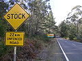
About 45 kilometres of the Yarrowitch to Wauchope section is unfenced and livestock (cattle) may be encountered there, along with other wild animals on most of the highway. Kangaroos are the most likely of those to be spotted, but wombats and other marsupials may be found.

History

Work commenced in 1838 with the use of convicts working from Port Macquarie towards a spot known as "Prisoners' Garden" about 20 km from Yarrowitch. Here it is said that the convicts were chained up each night. In 1842 the track from the Northern Tablelands to Port Macquarie was opened for the first time. Wool carried along this new route reduced the travelling time to 10 days, as opposed to 12–14 weeks for the trip to Maitland. The section from Walcha to Bendemeer existed as a mapped road in 1857, was surveyed in 1867, and proclaimed a Parish Road in c.1889. West of Walcha the road was only suitable for bullock teams and they too had difficulties, especially with the ranges. [4]

The steep range section from Yarras to Yarrowitch was in serious need of repair in 1925 when the Main Roads Board was formed. Following a re-survey in 1927 the road was altered between Yarras and Tobins Camp.

The passing of the Main Roads Act of 1924 [5] through the Parliament of New South Wales provided for the declaration of Main Roads, roads partially funded by the State government through the Main Roads Board (later the Department of Main Roads, and eventually Transport for NSW). Oxley Highway was declared (as Main Road No. 11) from the intersection with North Coast Highway (today Pacific Highway) near Wauchope, via Walcha, Tamworth, Gunnedah, Coonabarabran, and Gilgrandra to the intersection with North-Western Highway (today Mitchell Highway) at Trangie, Main Road 202 was declared from Nevertire to Warren (and continuing north to Quambone eventually to Coonabrarbran), and Main Road 203 was declared from Warren to Collie, on the same day, 8 August 1928; [2] with the passing of the Main Roads (Amendment) Act of 1929 [6] to provide for additional declarations of State Highways and Trunk Roads, these were amended to State Highway 11 and Main Roads 202 and 203 on 8 April 1929.

Oxley Highway was split into two parts, with the section between Tamworth and Bendemeer defined as part of Great Northern Highway (known as New England Highway from March 1933), on 23 June 1931; as a consequence Oxley Highway was re-declared to run from Trangie to Tamworth, and then from Bendemeer to Wauchope. [7] On 30 September 1933 the section between Walcha and Port Macquarie was officially opened; Walcha Shire maintained 106 km of the highway until July 1966 when this part was taken over by the Department of Main Roads.

The western end of the highway was rerouted through Warren to terminate at Nevertire instead on 13 June 1951, subsuming Main Road 203 and the alignment of Main Road 202 between Warren and Nevertire; Main Road 202 was truncated at Warren as a result, and Main Road 347 was extended along the old alignment from Collie to Trangie (and continuing south via Albert to Melrose). [8] Newell Highway was declared a National Highway in 1992, and was re-declared to form one continuous highway on 15 January 1993: as a consequence, Oxley Highway was split into three parts, re-declared to run from the intersection with Mitchell Highway in Nevertire to the intersection with Newell Highway in Gilgandra, then from the intersection with Newell Highway just northeast of Coonabarabran to Tamworth, and then from Bendemeer to Port Macquarie. [9]

The passing of the Roads Act of 1993 [10] updated road classifications and the way they could be declared within New South Wales. Under this act, Oxley Highway today retains its declaration as Highway 11, from Nevertire to Gilgandra, then from Coonabarabran to Tamworth, and then from Bendemeer to Port Macquarie. [11]

Oxley Highway was signed National Route 34 across its entire length in 1955. With the conversion to the newer alphanumeric system in 2013, this was replaced with route B56 between Coonabarabran and Port Macquarie, with the rest of the highway west of Coonabarabran unallocated. [12]

Major intersections

LGALocationkm [1] miDestinationsNotes
Warren Nevertire 0.00.0AUS Alphanumeric Route A32.svg Mitchell Highway (A32 northwest, southeast)  Broken Hill, Bourke, Nyngan, Dubbo Western terminus of western section of highway
Nevertire-Bogan Road (southwest)  Tottenham, Tullamore
Gilgandra Gilgandra 105.065.2AUS Alphanumeric Route B55.svg Castlereagh Highway (B55 north)  Coonamble, Walgett Western terminus of concurrency with Castlereagh Highway
105.165.3AUS Alphanumeric Route A39.svg Newell Highway (A39 south)  Dubbo, Parkes Eastern terminus of western section of highway
Gap in route
Warrumbungle Coonabarabran 204.3126.9AUS Alphanumeric Route A39.svg Newell Highway (A39 north)  Narrabri, Moree Western terminus of central section of highway
Western terminus of route B56
Gunnedah Gunnedah 305.2189.6 Mungindi railway line
305.6189.9AUS Alphanumeric Route B51.svg Kamilaroi Highway (B51 north)  Boggabri, Narrabri Concurrency with Kamilaroi Highway
307.8191.3AUS Alphanumeric Route B51.svg Kamilaroi Highway (B51 south)  Quirindi
Peel River 381.1236.8Bridge (no known official name)
Tamworth Tamworth 378.8235.4 Main North railway line
381.7237.2AUS Alphanumeric Route B95.svg Fossickers Way (B95)  Manilla, Warialda
382.8237.9AUS Alphanumeric Route A15.svg New England Highway (A15 south)  Scone, Aberdeen Eastern terminus of central section of highway
Gap in route
Tamworth Bendemeer 422.4262.5AUS Alphanumeric Route A15.svg New England Highway (A15 north)  Uralla, Armidale Western terminus of eastern section of highway
Walcha Woolbrook 447.5278.1 Main North railway line
Walcha 472.0293.3 Thunderbolts Way   Uralla, Nowendoc, Gloucester
Apsley River 472.1293.3Blue Hogan Bridge
Tia River 507.5315.3Bridge (no known official name)
Yarrowitch River 520.5323.4Bridge (no known official name)
Ellenborough River 601.6373.8Bridge (no known official name)
Port Macquarie-Hastings Wauchope 635.4394.8 North Coast railway line
Sancrox-Thrumster boundary644.4400.4AUS Alphanumeric Route A1.svg Pacific Highway (A1)  Kempsey, Macksville, Taree, Newcastle
Port Macquarie 653.0405.8 Hastings River Drive (north)  Telegraph Point, to AUS Alphanumeric Route A1.svg Pacific Highway
Ocean Drive (south)  Lake Cathie, Laurieton
Gordon Street  Port Macquarie Eastern terminus of eastern section of highway
Eastern terminus of route B56
1.000 mi = 1.609 km; 1.000 km = 0.621 mi

See also

Related Research Articles

<span class="mw-page-title-main">New England (New South Wales)</span> Australian region

New England is a geographical region in the north of the state of New South Wales, Australia, about 60 km inland from the Tasman Sea. The area includes the Northern Tablelands and the North West Slopes regions. As of 2021, New England had a population of 185,560, with over a quarter of the people living in the area of Tamworth Regional Council.

<span class="mw-page-title-main">Coonabarabran</span> Town in New South Wales, Australia

Coonabarabran is a town in Warrumbungle Shire that sits on the divide between the Central West and North West Slopes regions of New South Wales, Australia. At the 2016 census, the town had a population of 2,537,and as of 2021, the population of Coonabarabran and its surrounding area is 3,477. Local and district residents refer to the town as 'Coona'. Coonabarabran is the gateway to the Warrumbungle National Park and the Pilliga Forest.

<span class="mw-page-title-main">Newell Highway</span> Highway in New South Wales, Australia

Newell Highway is a national highway in New South Wales (NSW), Australia. It provides the major road link between southeastern Queensland and Victoria via central NSW and as such carries large amounts of freight. At 1,058 kilometres (657 mi) in length, the Newell is the longest highway in NSW, and passes through fifteen local government areas.

<span class="mw-page-title-main">Mitchell Highway</span> Highway in Queensland and New South Wales

Mitchell Highway is an outback state highway located in the central and south western regions of Queensland and the northern and central western regions of New South Wales in Australia. The southern part of Mitchell Highway forms part of the National Highway A32 B71 corridor, which stretches from Sydney to Brisbane via Dubbo. Mitchell Highway also forms part of the shortest route between Sydney and Darwin, via Bourke and Mount Isa, making it an important road link for the transport of passengers and freight for regional New South Wales and Queensland. The highway is a part of route Alternative A2 between Augathella and Charleville, route A71 and B71 between Charleville and Nyngan, and part of route A32 between Nyngan and Bathurst.

<span class="mw-page-title-main">Mid-Western Highway</span> Highway in New South Wales

Mid-Western Highway, sometimes Mid Western Highway, is a 518-kilometre (322 mi) state highway located in the central western and northern Riverina regions of New South Wales, Australia. The highway services rural communities and links the Great Western, Mitchell, Olympic, Newell, Cobb and Sturt highways. Mid-Western Highway forms part of the most direct route road link between Sydney and Adelaide, with its eastern terminus in Bathurst and western terminus in Hay. It is designated part of route A41 between Bathurst and Cowra, and route B64 between Cowra and Hay.

<span class="mw-page-title-main">Castlereagh Highway</span> Highway in New South Wales and Queensland, Australia

Castlereagh Highway is a 790-kilometre (490 mi) state highway located in New South Wales and Queensland, Australia. From north to south the highway traverses South West Queensland and the North West Slopes, Orana, and Central West regions of New South Wales.

Illawarra Highway is a short state highway in New South Wales, Australia. It connects Wollongong to the Southern Highlands and links Princes Highway and Hume Highway. It is named after the geographical area it crosses, the Illawarra region.

<span class="mw-page-title-main">Walcha, New South Wales</span> Town in New South Wales, Australia

Walcha is a town at the south-eastern edge of the Northern Tablelands, New South Wales, Australia.

<span class="mw-page-title-main">Carnarvon Highway</span> Highway in Australia

Carnarvon Highway is a state highway in Queensland and New South Wales, Australia, linking the township of Rolleston in Queensland's Central Highlands Region, via the town of St George, eventually to Moree in northern New South Wales. It is the main access road to the Carnarvon National Park, and serves as a strategic route to take B-doubles and other large vehicles to the Queensland ports north of Rockhampton.

<span class="mw-page-title-main">Kidman Way</span> Highway in New South Wales

Kidman Way is a state rural road in the western Riverina and western region of New South Wales, Australia. The 643-kilometre (400 mi) highway services the Murrumbidgee Irrigation Area and outback communities and links the Newell Highway with the Sturt, Mid-Western, Barrier, Mitchell and Kamilaroi highways. The road is designated route B87 for its entire length, with its northern terminus at Bourke and its southern terminus just north of Jerilderie. Kidman Way is fully sealed and is accessible by two or four-wheel drive.

<span class="mw-page-title-main">Thunderbolts Way</span> Road in New South Wales, Australia

Thunderbolts Way is a 305-kilometre (190 mi) country road located in the Northern Tablelands region of New South Wales, Australia, linking Inverell via Bundarra, Uralla and Walcha to Gloucester The road is sealed and passes through thickly forested mountain areas with many nearby national parks and nature reserves.

<span class="mw-page-title-main">Riverina Highway</span>

Riverina Highway is a 220-kilometre (140 mi)-long state highway located in the Riverina region of New South Wales, Australia. The road was constructed over several decades with final asphalt concrete sealing completed during the 1960s.

<span class="mw-page-title-main">Appin Road</span> Road in New South Wales, Australia

Appin Road is a New South Wales secondary highway linking Campbelltown and Sydney's western suburbs with Wollongong. It is named after Appin, which lies on its path.

<span class="mw-page-title-main">Walcha Shire</span> Local government area in New South Wales, Australia

Walcha Shire is a local government area located in the New England region of New South Wales, Australia. The Shire is situated adjacent to the junction of the Oxley Highway and Thunderbolts Way and is 20 kilometres (12 mi) east of the Main North railway line passing through Walcha Road. The shire was formed on 1 June 1955 through the amalgamation of Apsley Shire and the Municipality of Walcha.

<span class="mw-page-title-main">Goldfields Way</span>

Goldfields Way is a 116-kilometre (72 mi) country road in the northern part of the Riverina region of New South Wales, connecting Wyalong via Temora to Old Junee.

<span class="mw-page-title-main">Yarrowitch, New South Wales</span> Town in New South Wales, Australia

Yarrowitch is a small rural locality on the Northern Tablelands, New South Wales, Australia. It is located in the picturesque Yarrowitch River Valley on the Oxley Highway 48 kilometres east of Walcha. The settlement is included in the Walcha Shire Local Government Area in the New England region. The locality is at an elevation of about 995 metres and the area is part of Vernon County. At the 2011 census, the Yarrowitch area had a population of 167.

<span class="mw-page-title-main">Ellenborough, New South Wales</span> Town in New South Wales, Australia

Ellenborough is a parish and village straddling the Oxley Highway and the Ellenborough River, less than one kilometre south of its confluence with the Hastings River. The village is about 33 km west of Wauchope and approximately 130 km east of Walcha. The boundaries are within the Port Macquarie-Hastings Council and Macquarie County.

<span class="mw-page-title-main">Long Flat, New South Wales</span> Town in New South Wales, Australia

Long Flat is a rural village situated on the Oxley Highway and the southern bank of the Hastings River. This village is about 50 kilometres west of Port Macquarie, 30 kilometres west of Wauchope and 133 km east of Walcha. The boundaries are within the Port Macquarie-Hastings Council Local Government Area and Macquarie County.

<span class="mw-page-title-main">Electoral district of Oxley</span> State electoral district of New South Wales, Australia

Oxley is an electoral district of the Legislative Assembly in the Australian state of New South Wales.

References

  1. 1 2 Google (11 August 2022). "Oxley Highway" (Map). Google Maps . Google. Retrieved 11 August 2022.
  2. 1 2 "Main Roads Act, 1924-1927". Government Gazette of the State of New South Wales. No. 110. National Library of Australia. 17 August 1928. pp. 3814–20. Archived from the original on 3 August 2022. Retrieved 1 August 2022.
  3. Oxley Highway, Great Road Rides – New South Wales. Retrieved 25 May 2008. Archived 19 July 2008 at the Wayback Machine
  4. Donald, J.Kay, Exploring the North Coast and New England, Kangaroo Press, Kenthurst, 1978
  5. State of New South Wales, An Act to provide for the better construction, maintenance, and financing of main roads; to provide for developmental roads; to constitute a Main Roads Board Archived 11 August 2022 at the Wayback Machine 10 November 1924
  6. State of New South Wales, An Act to amend the Main Roads Act, 1924-1927; to confer certain further powers upon the Main Roads Board; to amend the Local Government Act, 1919, and certain other Acts; to validate certain payments and other matters; and for purposes connected therewith. Archived 12 August 2022 at the Wayback Machine 8 April 1929
  7. "Main Roads Act, 1924-1929". Government Gazette of the State of New South Wales. No. 88. National Library of Australia. 10 July 1931. p. 2370. Archived from the original on 12 January 2023. Retrieved 12 January 2023.
  8. "Main Roads Act, 1924-1950". Government Gazette of the State of New South Wales. No. 110. National Library of Australia. 6 July 1951. p. 1965. Archived from the original on 12 January 2023. Retrieved 12 January 2023.
  9. "State Roads Act 1986". Government Gazette of the State of New South Wales. No. 5. National Library of Australia. 15 January 1993. p. 125. Archived from the original on 29 August 2022. Retrieved 29 August 2022.
  10. State of New South Wales, An Act to make provision with respect to the roads of New South Wales; to repeal the State Roads Act 1986, the Crown and Other Roads Act 1990 and certain other enactments; and for other purposes. Archived 11 August 2022 at the Wayback Machine 10 November 1924
  11. Transport for NSW (August 2022). "Schedule of Classified Roads and Unclassified Regional Roads" (PDF). Government of New South Wales. Retrieved 1 August 2022.
  12. "Road number and name changes in NSW" (PDF). Roads & Maritime Services . Government of New South Wales. 2012. Archived from the original (PDF) on 25 March 2016. Retrieved 7 November 2016.

Commons-logo.svg Media related to Oxley Highway at Wikimedia Commons Wikivoyage-Logo-v3-icon.svg Oxley Highway travel guide from Wikivoyage