Big River Way

Last updated

Big River Way

Australia New South Wales location map blank.svg
Red pog.svg
South end
Red pog.svg
North end
Coordinates
General information
TypeRural road
Length55 km (34 mi) [1]
Gazetted 29 May 2020 [2]
Maintained by Transport for NSW
Route number(s)
  • AUS Alphanumeric Route B91.svg(2020–present)
    (Glenugie–South Grafton)
  • AUS Alphanumeric Route B76.svg(2020–present)
    (South Grafton–Tyndale)
Former
route number
AUS Alphanumeric Route A1.svg A1 (2013–2020)
Australian national route 1.svg National Route 1 (1955–2013)
Entire route
Major junctions
South endAUS Alphanumeric Route A1.svg Pacific Highway
Glenugie, New South Wales
 AUS Alphanumeric Route B76.svg Gwydir Highway
AUS Alphanumeric Route B91.svg Summerland Way
North endAUS Alphanumeric Route A1.svg Pacific Highway
Maclean, New South Wales
Location(s)
Region Northern Rivers
LGA(s) Clarence Valley Council
Major settlements South Grafton, Grafton, Ulmarra
Highway system

Big River Way is a road in the Northern Rivers region of New South Wales that connects the Pacific Highway to the city of Grafton. It runs along a former section of the Pacific Highway that was bypassed by a newer alignment in 2020.

Contents

Route

Big River Way branches from Pacific Highway at Glenugie and follows the former Pacific Highway alignment via the city of Grafton and the town of Tyndale to Maclean, which runs along the Clarence River and South Arm.

History

Many sections of the Pacific Highway had been bypassed since 1996 as part of the Pacific Highway Upgrade. The section between Glenugie and Maclean was due to be bypassed by a new alignment in 2020. The existing alignment was proposed to be renamed when the new alignment opens, with community consultation undertaken in 2019 to obtain suggestions and feedback from the community. Originally, the route names of Gwydir Highway and Summerland Way were to be extended along the road alignment towards Tyndale and Glenugie respectively. However, this was not supported by the community and so a local name was to be given instead. [3] The route numbers of Gwydir Highway and Summerland Way, route B76 and route B91 respectively, would still be extended along the road alignment. In December 2019, Clarence Valley Council voted to endorse Big River Way as the new name for submission to the Geographical Names Board of New South Wales (GNB), [4] and in February 2020, the new name was approved by the GNB. [5] [6]

The new alignment of the highway between Tyndale and Maclean opened on 1 April 2020. [7] On a temporary basis, the northern end of the old Pacific Highway only connected to Cameron Street, with a left-in left-out temporary access to the newly-aligned Pacific Highway located to the south. [8] On 19 May 2020, the new alignment between Glenugie and Tyndale opened and bypassed Grafton. [9] [10] The old alignment was the site of the Grafton bus crash in October 1989 when a semi-trailer and a bus collided head-on, resulting in the deaths of 21 people. [11]

A week later, on 26 May 2020, the old Pacific Highway at Grafton was realigned onto a new link road intersecting perpendicular to Iolanthe Street (Summerland Way), as part of the New Grafton Bridge project. The previous alignment of the old Pacific Highway was reduced to northbound only. [12] Three days later, on 29 May 2020, the old alignment of Pacific Highway between Glenugie and Maclean was officially renamed and gazetted as Big River Way. [2]

In June 2020, Transport for NSW began to propose safety improvement upgrades on the Big River Way between Glenugie and Tyndale. [13] [14]

In August 2020, the Maclean Interchange fully opened and the Big River Way connected to a new roundabout with connections to Cameron Street and direct on-ramp and off-ramps to Pacific Highway. [15] The temporary access to Pacific Highway to the south was also closed. [16] In the same month, the roundabout at the intersection of Big River Way and Charles Street (Gwydir Highway) was completed and opened to traffic, marking the completion of major works on the New Grafton Bridge project. [17]

The section between Glenugie and Grafton is signposted as B91, the route number for Summerland Way, and the section between Grafton and Tyndale is signposted B76, the route number for Gwydir Highway. [18]

The passing of the Roads Act of 1993 [19] updated road classifications and the way they could be declared within New South Wales. Under this act, Gwydir Highway (as Highway 12) was officially extended east along Big River Way from South Grafton to the Tyndale North interchange, and Summerland Way (as Main Road 83) was officially extended south along Big River Way from South Grafton to the Glenugie interchange, on 5 July 2022, [20] although the road is still known locally and sign-posted as Big River Way. Gwydir Highway and Summerland Way today, as parts of Highway 12 and Main Road 83 respectively, still retain these declarations. [21]

Major junction list

Big River Way is entirely contained within the Clarence Valley Council local government area.

Locationkm [1] miDestinationsNotes
Glenugie00.0AUS Alphanumeric Route A1.svg Pacific Highway (A1 south) – Coffs Harbour, Newcastle, Sydney Southern terminus of Big River Way and route B91
1.30.81Eight Mile Lane – Sandy Crossing, WooliTo AUS Alphanumeric Route A1.svg Pacific Highway (A1 north)  Tweed Heads, Gold Coast, Brisbane)
South Grafton 13.38.3AUS Alphanumeric Route B76.svg Charles Street (Gwydir Highway) (B76)  Glen Innes, Moree, Walgett Southern terminus of concurrency with route B76/B91 at roundabout
13.68.5AUS Alphanumeric Route B91.svg Iolanthe Street (Summerland Way) (B91)  Grafton, Casino, Kyogle Northern terminus of concurrency with route B76/B91 at roundabout
Tyndale41.625.8Bensons Lane – TyndaleTo AUS Alphanumeric Route A1.svg Pacific Highway (A1 south)  Coffs Harbour, Newcastle, Sydney
43.427.0AUS Alphanumeric Route A1.svg Pacific Highway (A1 north)  Tweed Heads, Gold Coast, Brisbane No access between Pacific Highway and Big River Way (north)
Northern terminus of route B76
Maclean 55.034.2AUS Alphanumeric Route A1.svg Pacific HighwaySydney, Coffs Harbour, Tweed Heads, Brisbane
Cameron Street (west)  Maclean
Goodwood Street (east) – Townsend, Brooms Head
Maclean Interchange
Northern terminus of Big River Way at roundabout
1.000 mi = 1.609 km; 1.000 km = 0.621 mi

See also

Related Research Articles

<span class="mw-page-title-main">Pacific Highway (Australia)</span> Highway in New South Wales and Queensland

Pacific Highway is a 790-kilometre-long (491 mi) national highway and major transport route along the central east coast of Australia, with the majority of it being part of Australia's Highway 1. The highway and its adjoining Pacific Motorway between Brisbane and Brunswick Heads and Pacific Motorway between Sydney and Newcastle links the state capitals of Sydney in New South Wales with Brisbane in Queensland, approximately paralleling the Tasman Sea and the Coral Sea of the South Pacific Ocean coast, via regional cities and towns like Gosford, Newcastle, Taree, Port Macquarie, Kempsey, Coffs Harbour, Grafton, Ballina, Byron Bay, Tweed Heads and the Gold Coast, which is part of Queensland. Additionally, between Brunswick Heads and Port Macquarie, the road is also signed as Pacific Motorway, but has not been legally gazetted as such.

<span class="mw-page-title-main">Gwydir Highway</span>

Gwydir Highway is a 568-kilometre (353 mi) state highway in northern New South Wales, Australia. The highway was named after the Gwydir River, which in turn was named after a locale in Wales.

<span class="mw-page-title-main">Barton Highway</span> Highway in New South Wales and the Australian Capital Territory

Barton Highway is a highway in New South Wales and the Australian Capital Territory. It connects Canberra to Hume Highway at Yass, and it is part of the route from Melbourne to Canberra. It is named in honour of Sir Edmund Barton, the first Prime Minister of Australia.

<span class="mw-page-title-main">Clarence Valley Council</span> Local government area in New South Wales, Australia

Clarence Valley Council is a local government area in the Northern Rivers region of New South Wales, Australia.

<span class="mw-page-title-main">Mount Lindesay Highway</span> Highway in Queensland

Mount Lindesay Highway is an Australian national highway located in Queensland. The highway runs southwest from Brisbane, where it leaves Ipswich Road in the suburb of Moorooka, to the Queensland – New South Wales border and is 116 kilometres (72 mi) in length. For most of its length it is roughly aligned with the Sydney–Brisbane rail corridor. At its southern end these transport routes take different passes over the Scenic Rim into the Northern Rivers region. It is designated National Route 13.

<span class="mw-page-title-main">Summerland Way</span>

Summerland Way is a 199–kilometre state route, designated B91, in New South Wales. It runs generally north from Grafton to the state border with Queensland just west of Mount Lindesay, and continues from there into Queensland as Mount Lindesay Highway. It was named as the region in runs through is a popular tourist area for people during summer.

<span class="mw-page-title-main">Pacific Motorway (Brisbane–Brunswick Heads)</span> Motorway in New South Wales and Queensland

The Pacific Motorway is a motorway in Australia between Brisbane, Queensland, and Brunswick Heads, New South Wales, through the New South Wales–Queensland border at Tweed Heads.

<span class="mw-page-title-main">Clarence River (New South Wales)</span> River in New South Wales, Australia

The Clarence River is a river situated in the Northern Rivers district of New South Wales, Australia. It rises on the eastern slopes of the Great Dividing Range, in the Border Ranges west of Bonalbo, near Rivertree at the junction of Koreelah Creek and Maryland River, on the watershed that marks the border between New South Wales and Queensland. It flows generally south, south east and north east, and is joined by twenty-four tributaries including Tooloom Creek and the Mann, Nymboida, Cataract, Orara, Coldstream, Timbarra, and Esk rivers. It descends 256 metres (840 ft) over the course of its 394-kilometre (245 mi) length and empties into the Coral Sea in the South Pacific Ocean, between Iluka and Yamba.

<span class="mw-page-title-main">Pacific Motorway (Sydney–Newcastle)</span> Motorway in New South Wales, Australia

The M1 Pacific Motorway is a 127-kilometre motorway linking Sydney to Newcastle via the Central Coast and Hunter regions of New South Wales. Formerly known but still commonly referred to by both the public and the government as the F3 Freeway, Sydney–Newcastle Freeway, and Sydney–Newcastle Expressway, it is part of the AusLink road corridor between Sydney and Brisbane. The name "F3 Freeway" reflects its former route allocation before it was decommissioned and replaced by the rollout of alphanumeric signposts.

<span class="mw-page-title-main">Maclean, New South Wales</span> Town in New South Wales, Australia

Maclean is a town in Clarence Valley local government area in the Northern Rivers region of New South Wales, Australia. It is on the Clarence River and near the Pacific Highway. At the 2021 census, Maclean had a population of 2,778, total urban area including Townsend and Gulmarrad is more than 8,304. The Maclean, Yamba and Iluka area known as the Lower Clarence had a combined population of 17,533. Its industries are tourism, sugar cane production, farming and river-prawn trawling. Together with Grafton, Maclean is the shared administrative centre for the Clarence Valley Council local government area.

<span class="mw-page-title-main">Grafton Bridge (New South Wales)</span> Bridge in New South Wales, Australia

The Grafton Bridge is a heritage-listed bascule truss bridge that carries the Bent Street and North Coast railway line across the Clarence River in Grafton, New South Wales, Australia. The bridge links the Grafton central business district with South Grafton, and was added to the New South Wales State Heritage Register on 2 April 1999.

<span class="mw-page-title-main">Harwood Bridge</span> Mostly disused roadbridge in New South Wales, Auatralia

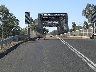
The Harwood Bridge is a two-lane steel truss bridge which carried the Pacific Highway over the Clarence River in the Northern Rivers region of New South Wales, Australia from 1966 until 2019, when it was replaced by a four-lane 1.5-kilometre-long (4,921 ft) concrete bridge, located 20 metres (66 ft) to its east. The Harwood Bridge has been retained to provide access to Harwood Island.

Camden Valley Way is a 23-kilometre (14 mi) arterial road between the southwestern fringes of suburban Sydney and the historic town of Camden. It is a former alignment of Hume Highway.

<span class="mw-page-title-main">Glenugie Peak</span> Geologic formation in New South Wales

Glenugie Peak, also known as Mount Elaine or as Glen Ugie Peak, is a mountain that forms part of the ridge surrounding the Clarence Moreton Basin. It is situated in the Northern Rivers region of New South Wales, Australia, and has an elevation of 316 metres (1,037 ft) above sea level. The mountain is located near the Pacific Highway, south of the town of Grafton and approximately 6 kilometres (3.7 mi) west north-west of the locality of Calamia.

<span class="mw-page-title-main">Roads and Maritime Services</span> Australian state government agency

Roads and Maritime Services was an agency of the New South Wales Government responsible for building and maintaining road infrastructure and managing the day-to-day compliance and safety for roads and waterways.

The major intersections of the Pacific Highway in Australia, spread over 790 kilometres (490 mi) on the eastern seaboard of New South Wales, comprise a mix of freeway grade-separated conditions, suburban and urban roads.

The Macleay Valley Way is a road in the Mid North Coast region of New South Wales that connects the Pacific Highway to Kempsey and Frederickton. It runs along a former section of the Pacific Highway that was bypassed by a newer alignment between 2013 and 2016.

Giinagay Way is a road in the Mid North Coast region of New South Wales linking the towns of Warrell Creek, Macksville, Nambucca Heads and Urunga to Pacific Highway. It runs along a former section of the highway between Eungai Creek and Raleigh that was bypassed by a new parallel alignment between 2016 and 2018.

Solitary Islands Way is a road in the Mid North Coast region of New South Wales, located north of the city of Coffs Harbour. It links the towns of Woolgoolga and Corindi Beach to the Pacific Highway. It consists of a mix of newly constructed roads, pre-existing Council-owned roads and former sections of the highway that were bypassed by new alignments in 2013 and 2017.

<span class="mw-page-title-main">Balun Bindarray Bridge</span> Bridge in New South Wales, Australia

The Balun Bindarray Bridge, located 70 metres (230 ft) east of the Grafton Bridge and consists of two lanes and has been designed to be increased to four lanes when traffic levels require it. The bridge also carries a grade-separated footpath and cycleway, opened to traffic on 12 December 2019.

References

  1. 1 2 Google (7 December 2020). "Big River Way" (Map). Google Maps . Google. Retrieved 7 December 2020.
  2. 1 2 "Clarence Valley Council - Roads Act 1993 - Naming of Roads" (PDF). Government Gazette of the State of New South Wales. No. 107. 29 May 2020. p. 2165. Archived (PDF) from the original on 1 December 2022. Retrieved 8 December 2020.
  3. "Ordinary Council Meeting - Minutes - 26 November 2019 - Item 6a.19.031". Clarence Valley Council. 26 November 2019. Retrieved 7 December 2020.
  4. "New name for old highway". Clarence Valley Independent. 4 December 2019. Retrieved 7 December 2020.
  5. "Pacific Hwy renamed between Glenugie and Maclean". Transport for NSW - Roads and Maritime. 28 February 2020. Retrieved 7 December 2020.
  6. "Part of Pacific Highway to be renamed following construction". Roads and Infrastructure. 3 March 2020. Retrieved 4 December 2020.
  7. "Safer journeys between Tyndale and Maclean". Mirage News. 1 April 2020. Retrieved 14 April 2020.
  8. "Woolgoolga to Ballina Pacific Highway upgrade - Tyndale to Maclean - Project update" (PDF). Pacific Highway Upgrade. Transport for NSW. March 2020. Retrieved 14 March 2020.
  9. "New Highway Upgrade Open". Big Rigs. Archived from the original on 27 May 2020.
  10. "Pacific Highway from Glenugie to Tyndale open". Echo Netdaily. 19 May 2020. Retrieved 3 August 2020.
  11. "Grafton bus crash section of Pacific Highway replaced more than 30 years later". ABC News. 19 May 2020. Retrieved 4 December 2020.
  12. "Traffic changes in South Grafton from Tuesday 26 May 2020" (PDF). Transport for NSW - Roads and Maritime. May 2020. Retrieved 4 December 2020.
  13. "Proposed safety improvements along Big River Way between Glenugie and Tyndale" (PDF). Transport for NSW - Roads and Maritime. June 2020. Retrieved 4 December 2020.
  14. "Have your say on shaping Big River way". Transport for NSW - Roads and Maritime. 26 June 2020. Retrieved 4 December 2020.
  15. "Maclean Interchange opens to traffic". Transport for NSW - Roads and Maritime. 4 August 2020. Retrieved 4 December 2020.
  16. "Permanent traffc changes Maclean interchange and Pacific Motorway, Maclean" (PDF). Transport for NSW - Pacific Highway Upgrade. July 2020. Retrieved 4 December 2020.
  17. "New Grafton bridge - Project update" (PDF). Transport for NSW. August 2020. Retrieved 17 February 2021.
  18. "New Grafton Bridge - Proposed directional signage plan - Stage 3 - Project completion (Target Date - June 2020)" (PDF). Transport for NSW - Roads and Maritime. Retrieved 3 December 2020.
  19. State of New South Wales, An Act to make provision with respect to the roads of New South Wales; to repeal the State Roads Act 1986, the Crown and Other Roads Act 1990 and certain other enactments; and for other purposes. Archived 11 August 2022 at the Wayback Machine 10 November 1924
  20. "Roads Act 1993" (PDF). Government Gazette of the State of New South Wales. No. 323. Legislation NSW. 15 July 2022. pp. 3–9. Archived (PDF) from the original on 1 December 2022. Retrieved 1 December 2022.
  21. Transport for NSW (August 2022). "Schedule of Classified Roads and Unclassified Regional Roads" (PDF). Government of New South Wales. Archived from the original (PDF) on 25 August 2022. Retrieved 1 August 2022.